INTRODUCTION
The Southeastern Coastal Plain aquifer system consists of four regional aquifers that are composed predominately of clastic rocks ranging in age from Cretaceous to late Tertiary. The aquifer system underlies an area of about 90,000 square miles in the Coastal Plain of Alabama, Georgia, and South Carolina and extends for a short distance into northern Florida (fig. 69). The system also extends westward throughout much of Mississippi, where it underlies an area of about 32,000 square miles. The upper part of the Southeastern Coastal Plain aquifer system grades into the Mississippi embayment aquifer system in western Alabama. The Mississippi part of the aquifer system is within Segment 5 of this Atlas.
The southern and southeastern limits of the aquifer system extend past the coastline in most places. That is, the rocks that comprise some of the water-yielding units of the aquifer system are permeable enough to maintain their character as aquifers for some distance offshore. However, the aquifers contain saltwater with dissolved-solids concentrations of 10,000 milligrams per liter or more near the coast in most areas. The limit of the aquifer system in peninsular Florida is the place at which the rocks of the lowermost regional aquifer change from a sand and clay sequence to low-permeability, calcareous clay and sand, and carbonate rocks. This change is approximately in the area shown by the dashed line in figure 69. West of Jacksonville, Fla., rocks of this lowermost aquifer are locally absent. Shallower regional aquifers in the system change to low-permeability rocks in southern Georgia. The northern limit of the aquifer system is its contact with crystalline rocks or consolidated sedimentary rocks of Paleozoic age at the Fall Line, which marks the updip extent of Coastal Plain sediments.
Rocks of the Southeastern Coastal Plain aquifer system were deposited in fluvial, deltaic and shallow-marine environments during a series of transgressions and regressions of the sea. Coarser grained, fluvial to deltaic sediments are located primarily near the updip extent of the aquifer system and consist primarily of coarse sand and gravel that form productive aquifers (fig.70). Most of the aquifers in the system, however, consist chiefly of fine to coarse sand.
Confining units within the system are mostly silt and clay, except for a thick sequence of chalk in Alabama and Mississippi. All these fine-grained materials form effective confining units that retard the vertical movement of ground water, especially where they are thick. The proportion of clay in the aquifer system generally increases in the direction of the coastline; thus, even though the system thickens in this direction, its overall transmissivity is much less toward the coastline.
The interbedding of coarse- and fine-grained sediments is complex because of fluctuating sea level and resulting changes in energy conditions and in depositional environments. Rock types and textures may change greatly within short vertical or horizontal distances.
RELATION TO ADJACENT REGIONAL AQUIFER SYSTEMS
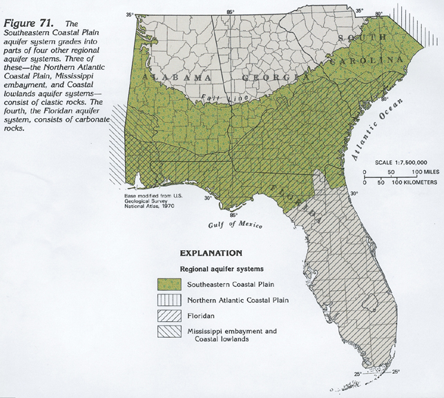
The Southeastern Coastal Plain aquifer system is adjacent to four regional aquifer systems. It grades laterally in to the Northern Atlantic Coastal Plain aquifer system to the northeast and is partly overlain by, and partly grades laterally into, the Floridan aquifer system to the south and the Mississippi embayment and Coastal lowlands aquifer systems to the west (fig. 71). The Northern Atlantic Coastal Plain aquifer system is located in Segments 11 and 12 of this Atlas, the Mississippi embayment aquifer system is located in Segments 5 and 10, and the Coastal lowlands aquifer system is located in Segments 4 and 5.
The predominately clastic nature of the aquifers and confining units of the Southeastern Coastal Plain aquifer system persists as the system grades into the Northern Atlantic Coastal Plain aquifer system near the North Carolina-South Carolina State line. The Mississippi embayment and Coastal lowlands aquifer systems to the west likewise are composed of clastic rocks. Parts of these systems overlie the Southeastern Coastal Plain aquifer system and are separated from it by thick, low-permeability clay confining units; other parts are equivalent to, but are much thicker and more complex than, aquifers and confining units of the Southeastern Coastal Plain aquifer system.
The Floridan aquifer system to the southeast consists of a thick sequence of carbonate rocks that are partly equivalent to the clastic beds of the Southeastern Coastal Plain aquifer system. In places, thick sequences of carbonate strata of the Floridan aquifer system overlie the clastic rocks. There is no confining unit separating the two aquifer systems, and the major difference between them is that the Floridan aquifer system tends to be more permeable.
HYDROGEOLOGIC UNITS
There are many geologic formations in the complexly interbedded rocks that comprise the Southeastern Coastal Plain aquifer system. Likewise, there are many aquifers and confining units of local extent. Sequences of local aquifers may be grouped together and treated as a single, regionally extensive aquifer. One way to establish that local aquifers function as a single aquifer is to show that their hydraulic heads fluctuate in the same manner and at about the same time. Likewise, sequences of local confining units can be grouped as a single regional confining unit that impedes the vertical ground-water flow between regional aquifers.
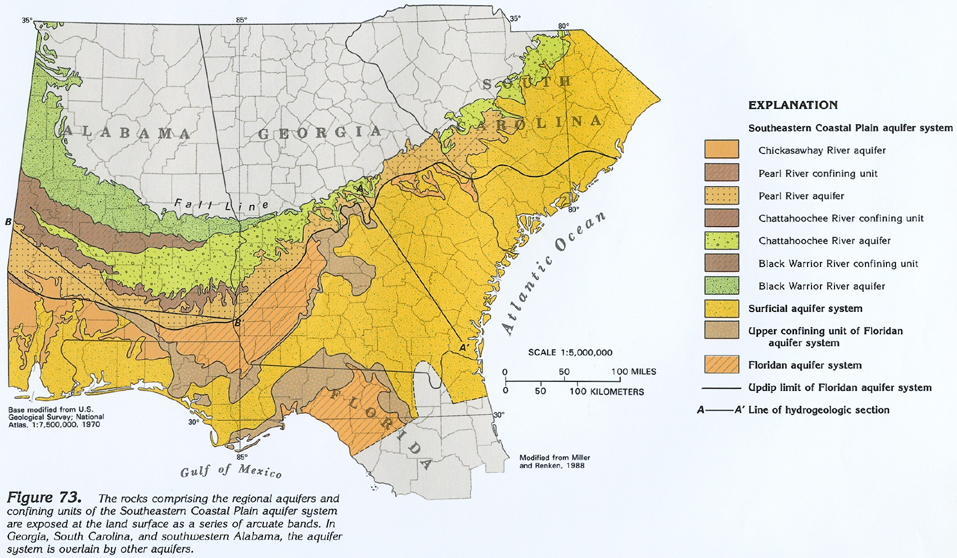
The sediments of the Southeastern Coastal Plain aquifer system have been grouped into seven regional hydrogeologic units-four regional aquifers separated by three regional confining units. The geologic formations comprising the four regional aquifers and the three regional confining units that separate them are shown in figure 72. Also shown in figure 72 are the Floridan aquifer system and the surficial aquifer system, which is generally thin and is not present everywhere. The Floridan aquifer system is hydraulically connected in different places to three of the regional aquifers of the Southeastern Coastal Plain aquifer system (fig. 72). In most places, there is no confining unit between the two aquifer systems and ground water can pass freely between them.
Several geologic formations are included in each of the geohydrologic units shown in figure 72. In some places, the boundaries of the formations coincide with those of the hydrogeologic units; in other places, they do not. For example, the top of the Gosport Sand in Alabama is the same as the top of a regional aquifer. In contrast, the Cape Fear Formation in South Carolina is partly an aquifer and partly a confining unit. The regional hydrogeologic units differentiated are primarily units of similar permeability that hydraulically function in the same way. The regional aquifers are mostly sand with minor gravel and limestone beds, but they locally may contain clay beds. The regional confining units are primarily clay, silt, or chalk, but locally may contain sand beds.
Each of the regional aquifers of the Southeastern Coastal Plain aquifer system has been named for a major river that crosses the outcrop belt of the aquifer and, thus, exposes the aquifer. From youngest to oldest, the four regional aquifers differentiated in the system are the Chickasawhay River aquifer, the Pearl River aquifer, the Chattahoochee River aquifer, and the Black Warrior River aquifer. The regional confining units separating these aquifers bear the same name of the aquifer they overlie. For example, the Pearl River regional confining unit lies above the Pearl River regional aquifer and beneath the Chickasawhay River regional aquifer; and so on (fig. 72).
TOP OF THE AQUIFER SYSTEM
The rocks grouped into the four regional aquifers and the intervening three regional confining units of the Southeastern Coastal Plain aquifer system are exposed at the land surface, approximately as a series of arcuate bands (fig. 73). In Alabama, the rocks comprising the oldest geohydrologic unit, the Black Warrior River aquifer, are exposed farthest north, with successively younger rocks cropping out toward the Gulf Coast. In eastern Georgia and western South Carolina, the younger rocks that comprise the Pearl River aquifer are exposed at the land surface. These rocks completely cover the older rocks that comprise the Chattahoochee River and Black Warrior River aquifers and their intervening confining units.
In south-central Alabama, the clastic rocks that comprise the Chickasawhay River aquifer grade into carbonate rocks that comprise the upper part of the Floridan aquifer system (fig. 73); the Chickasawhay River aquifer does not extend east of this area. The sandy beds of the Chattahoochee River aquifer grade westward into clayey confining units in western Alabama, and the aquifer does not exist beyond that area. Carbonate rocks of the Floridan aquifer system overlap the clastic rocks of the Pearl River aquifer. No clayey confining unit separates these rocks except locally in western Alabama.
Rocks comprising the regional confining units of the Southeastern Coastal Plain aquifer system are not exposed at the land surface except in Alabama. Accordingly, permeable beds of some of the regional aquifers lie directly on top of each other in their outcrop areas in Georgia and South Carolina. However, the low-permeability rocks comprising the regional confining units are present in the subsurface in these two States.
VARIATIONS WITHIN THE AQUIFER SYSTEM
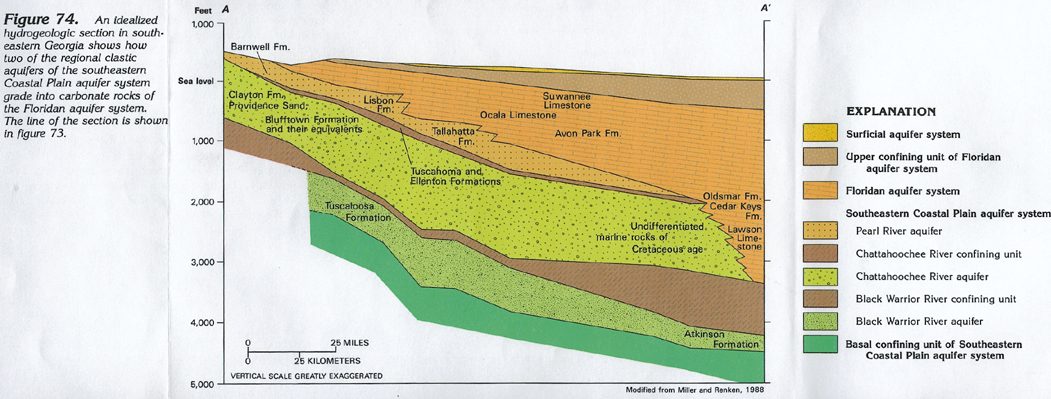
The different regional aquifers and confining units of the Southeastern Coastal Plain aquifer system thicken and thin in the subsurface, and in places are absent, as their permeability characteristics grade from those of an aquifer to those of a confining unit or vice versa. These gradational differences are shown on two hydrogeologic sections; one perpendicular and one parallel to the outcrop area of the aquifer system.
Hydrogeologic section A-A' in southeastern Georgia (fig. 74) shows that there are three regional aquifers that comprise the aquifer system there. The different geologic formations that comprise each aquifer are identified on the section. All the aquifers dip toward the southeast from the outcrop area. The thickness of each individual aquifer, and the aquifer system as a whole, is greatest near the middle of the section. The Black Warrior River aquifer extends farther to the southeast than do the two shallower aquifers. The Pearl River and Chattahoochee River aquifers, and the Chattahoochee River confining unit between them, all end near the coast. In the coastal area, the sandy aquifer material and the clayey confining-unit material of the Southeastern Coastal Plain aquifer system grade into carbonate rocks of the Floridan aquifer system. Near the northwest side of the section, the Pearl River and Chattahoochee River aquifers are in direct hydraulic contact.
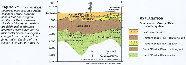
Hydrogeologic section B-B' (fig. 75) in southern Alabama shows the Pearl River aquifer is at the land surface. The Chattahoochee River aquifer and its overlying Chattahoochee River confining unit are present only in the eastern one-third of the section. They both merge to the west into the Pearl River aquifer and are included as part of it. The Black Warrior River confining unit is everywhere thicker than 1,000 feet along the line of the section. None of the data used to construct this section are from wells deep enough to completely penetrate the Black Warrior River aquifer, which contains mostly saltwater in the area of the section; the two shallower aquifers contain freshwater.
BASE OF THE AQUIFER SYSTEM
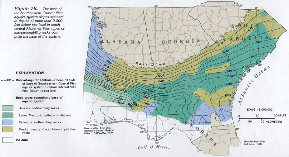
The base of the Southeastern Coastal Plain aquifer system consists of rocks of several types, all of which have extremely low permeability. The base of the system slopes gently from its inner margin toward the Atlantic Ocean and more steeply toward the Gulf of Mexico (fig. 76). Near the Georgia-Florida State line, the rocks that comprise the base of the aquifer system are warped into two deep basins separated by a high area that is a northwestward extension of the Peninsular arch in Florida. The base of the system is about 4,500 feet below sea level in the Southeast Georgia embayment and is about 10,000 feet below sea level in south-central Alabama. Westward, in Mississippi, the base of the aquifer system trends more northward due to the effect of downwarping in the Mississippi embayment.
The low-permeability rocks comprising the base of the aquifer system can be grouped into four categories (fig. 76). From oldest to youngest, these are: predominantly Precambrian crystalline rocks, including igneous and metamorphic rocks that are buried extensions of the Piedmont; Paleozoic sedimentary rocks that are mostly sandstone and shale in western Alabama, and black shale and white quartzite elsewhere; early Mesozoic rocks that are predominately coarse-grained redbeds intruded by diabase; and Jurassic sedimentary rocks that are mostly varicolored sandstone interbedded with shale.
REGIONAL AQUIFERS
Each of the four regional aquifers that comprise the Southeastern Coastal Plain aquifer system includes several smaller-scale aquifers. Even though the regional aquifers contain clayey confining units and can be locally subdivided, their overall water-yielding characteristics are similar throughout their extent. The rocks included in the Black Warrior River aquifer, for example, are everywhere more permeable than the rocks of the overlying and underlying confining units.
Chickasawhay River Aquifer
The Chickasawhay River aquifer is present in only a small area in southwestern Alabama, and, accordingly, is not mapped. This aquifer, the uppermost regional aquifer in the Southeastern Coastal Plain aquifer system, consists of sand and limestone beds of Oligocene and Miocene age. The Chickasawhay River aquifer lies above the Pearl River aquifer and is separated from it by the Pearl River confining unit. The Chickasawhay River aquifer is much thicker and more areally extensive in Mississippi; in Louisiana it becomes part of the Coastal lowlands aquifer system. The Chickasawhay River aquifer is located mostly in Segment 5 of this Atlas.
Pearl River Aquifer
The Pearl River aquifer is a thick sequence of sand with minor sandstone and gravel, and a few limestone beds. The sediments comprising the aquifer range in age from Paleocene to late Eocene and were deposited mostly in marine environments in the area mapped in figure 77. The aquifer is equivalent to the Mississippi embayment aquifer system to the west and southwest and to part of the Floridan aquifer system in southern Georgia and adjacent areas. The Pearl River aquifer and the Floridan aquifer system are hydraulically connected.
The top of the Pearl River aquifer slopes gently toward the Atlantic Ocean and the Gulf of Mexico (fig. 77). The seaward limit of the aquifer in Florida and Georgia is the area where it grades completely into carbonate rocks of the Floridan aquifer system. In southwestern Alabama, its limit is the area where it grades completely from sandy strata into low-permeability clay. The aquifer contains freshwater everywhere except for a small area in southwestern Alabama and panhandle Florida (fig. 77).
Chattahoochee River Aquifer
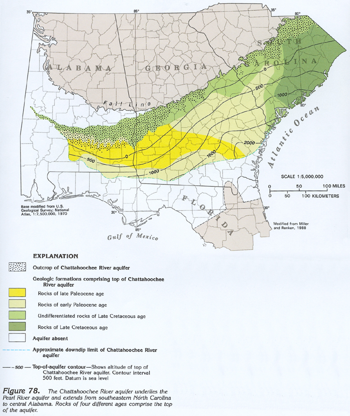
The Chattahoochee River aquifer lies above the Black Warrior River aquifer and the two are separated by the Black Warrior River confining unit. The Chattahoochee River aquifer is separated from the overlying Pearl River aquifer by the Chattahoochee River confining unit. The Chattahoochee River aquifer extends from southeastern North Carolina westward into central Alabama (fig. 78), where the lower part of the aquifer changes from sand to clay and chalk, and the clay confining unit over it pinches out (fig. 75). West of this area, equivalent permeable rocks are grouped with those of the Pearl River aquifer, and the fine-grained rocks in the lower parts of the aquifer are included in the Black Warrior River confining unit. The southern limit of the Chattahoochee River aquifer is where it grades into carbonate rocks of the lower part of the Floridan aquifer system.
Like the overlying Pearl River aquifer, the Chattahoochee River aquifer slopes gently seaward from its outcrop belt. Geologic formations included in the Chattahoochee River aquifer range in age from Late Cretaceous to Late Paleocene. The rocks are mostly sand beds with thin, lignitic clay lenses and locally include glauconitic sand and limestone. These rocks were deposited in marine environments except locally in South Carolina, where they were deposited in a fluvial environment.
Black Warrior River Aquifer
The basal aquifer of the Southeastern Coastal Plain aquifer system is the Black Warrior River aquifer. Although this regional aquifer crops out only in Alabama, Mississippi, and a small part of westernmost Georgia, it is extensive in the subsurface (fig. 79) and is the most widespread of the regional aquifers in the system. In North Carolina, the aquifer grades laterally into the basal aquifers of the Northern Atlantic Coastal Plain aquifer system. The top of the aquifer, as shown by the contours in figure 79, ranges from a few hundred feet above sea level in its outcrop area to about 7,000 feet below sea level in southwestern Alabama. The aquifer is absent in a wide band adjacent to the inner Coastal Plain margin in South Carolina and eastern Georgia. There, the Chattahoochee River aquifer lies directly on the low-permeability rocks of the base of the aquifer system.
The Black Warrior River aquifer consists mostly of Upper Cretaceous sand and clay that were deposited in fluvial, deltaic, and marine environments. Locally, sands of Early Cretaceous age are included in the aquifer in Alabama. The aquifer is displaced by faults in southwestern Alabama that have offset its top by as much as 500 feet. These faults do not affect the ground-water flow system, however, because they occur where the aquifer contains stagnant saltwater. About one-third of the aquifer contains water with dissolved-solids concentrations greater than 10,000 milligrams per liter, as shown in figure 79 .
GROUND-WATER FLOW
Recharge enters the Southeastern Coastal Plain aquifer system from precipitation on the outcrop areas of the aquifers. When reaching the water table, most of this water moves laterally to discharge at small streams in the outcrop area, evaporates, or is transpired by plants. Only a small part of the water percolates downward into the deeper parts of the aquifer system. In the outcrop areas, movement of the water is downward along generally short flowpaths until it reaches the area where the aquifers are confined. From this area, most of the movement is horizontal, along generally long flowpaths, until the water approaches discharge points, where its movement becomes again predominately vertical-but here, it moves upward, either toward a surface-water body or a shallower aquifer, either of which is a discharge area.
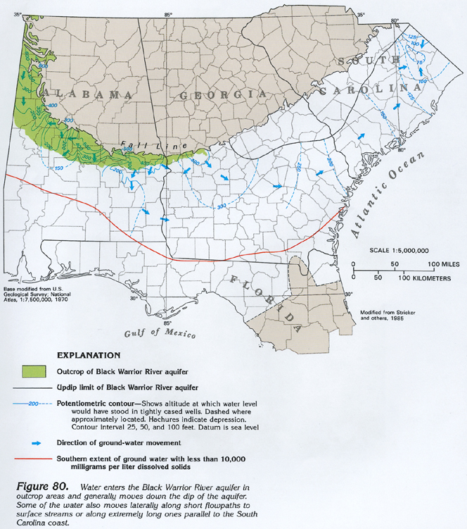
A map of the potentiometric surface (fig. 80) of the Black Warrior River aquifer shows that in outcrop areas, where water in the aquifer is under unconfined (water-table) conditions, it stands at high altitudes. These areas are primarily in Alabama, and the potentiometric surface is irregular because the aquifer is eroded by streams of various sizes that locally divert groundwater flow. As the aquifer becomes confined, its potentiometric surface is smoother and the contours representing that surface are more evenly spaced. Most of the water in the aquifer flows coastward and down the dip of the beds. However, an important component of flow is parallel to the Atlantic Ocean (perpendicular to dip), particularly in South Carolina where the water moves slowly northeastward along long flowpaths. The Chattahoochee River and Pearl River aquifers do not have this coast-parallel direction of flow. Most of the water in these two shallower aquifers moves down the dip of the aquifers.
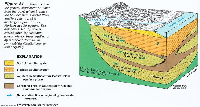
In southeastern Georgia, water moves readily between the Southeastern Coastal Plain and Floridan aquifer systems. Idealized conditions and the general direction of ground-water movement from the inner margin of the Coastal Plain to the Atlantic Ocean are shown in figure 81. In southeastern Georgia, only the Pearl River aquifer (of the three Southeastern Coastal Plain regional aquifers shown) extends to the land surface and receives direct recharge from precipitation. However, the Chattahoochee River confining unit that underlies the Pearl River aquifer pinches out updip, allowing water to leak freely downward from the Pearl River aquifer to the underlying Chattahoochee River aquifer. The Black Warrior River aquifer that lies still deeper is recharged in this area only by downward leakage across the confining unit that completely covers the aquifer.
Where the aquifers become confined, the flow arrows show that the predominant movement of the water is lateral and down the dip of the aquifers. Near the coast, the arrows turn upward as flow is blocked either by saltwater or by the aquifer becoming so fine-grained that its permeability is greatly decreased. Flow is then primarily vertical to shallower aquifers or surface-water bodies, such as the ocean. Some water leaks either downward from or upward to the Floridan aquifer system from the Southeastern Coastal Plain aquifer system, depending on which aquifer system has the higher hydraulic head at a given place. The saltwater shown in the coastal area of the Black Warrior River aquifer is stagnant. The horizontal flow arrow, shown near the right side of the figure, in this aquifer represents the coastal-parallel component of ground-water flow that is unique to the aquifer.
GROUND-WATER QUALITY
Water in each of the regional aquifers of the Southeastern Coastal Plain aquifer system undergoes similar chemical changes as it moves from outcrop areas down the hydraulic gradient into deeper, confined parts of the aquifers. Initial changes are gradual and result from chemical interactions between the water and the minerals comprising the rocks. In deep parts of the aquifers, changes result from the mixing of freshwater with saltwater.
The principal water-quality constituents that are used to characterize the ground water in the Southeastern Coastal Plain aquifer system are dissolved solids, dissolved iron, and dissolved chloride. Dissolved-solids concentrations are generally less than 50 milligrams per liter in outcrop recharge areas but increase as the water moves downgradient and dissolves some of the aquifer minerals. Concentrations greater than 500 milligrams per liter generally occur only where there is mixing of freshwater and saltwater. This mixing has produced dissolved-solids concentrations as large as 10,000 milligrams per liter in places.
Dissolved-iron concentrations generally are, less than 100 micrograms per liter in recharge areas but increase markedly downgradient where concentrations ranging from 1,000 to 10,000 micrograms per liter are present in bands parallel to outcrop areas. Farther downgradient, dissolved-iron concentrations decrease as the iron precipitates. Still farther downgradient, iron concentrations again increase in the freshwater-saltwater mixing zone.
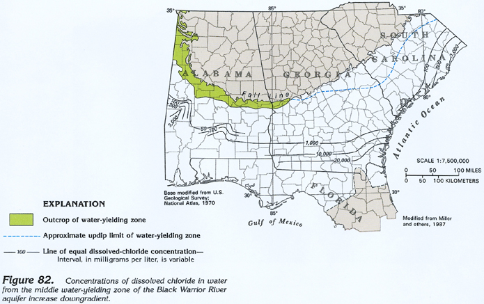
Dissolved-chloride concentrations have the same pattern as dissolved-solids concentrations; both relate in large part to the degree to which freshwater has flushed saltwater, entrapped during deposition of the sediments, from the aquifers. The distribution of dissolved-chloride concentrations in water from the middle part of the Black Warrior River aquifer is shown in figure 82 and represents the general distribution of chloride concentrations for all the aquifers. Concentrations increase downgradient, locally exceeding 3,000 milligrams per liter in west-central Alabama and 20,000 milligrams per liter in southern Georgia. The downgradient increase in concentrations is gradual to about 1,000 milligrams per liter, where there is a marked increase as the freshwater mixes with saltwater.
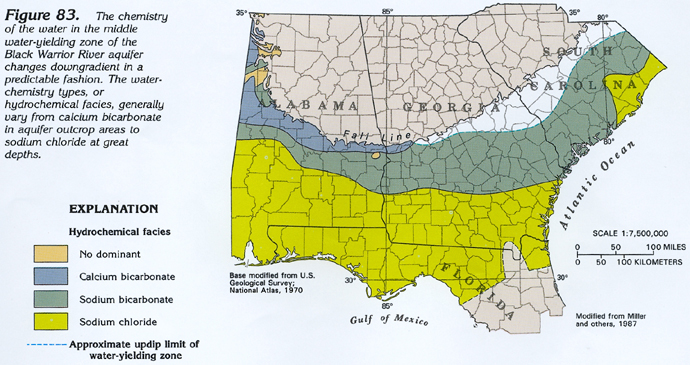
Classification of waters based on their dominant cations and anions are called hydrochemical facies. The distribution of these hydrochemical facies (fig. 83) shows the progressive change in the chemical character of the water as it moves through the aquifer. To demonstrate the classification used, a calcium bicarbonate water is one in which calcium ions account for more than 50 percent of the total cations in the water and bicarbonate ions account for more than 50 percent of the total anions. Where no ion exceeds 50 percent, the water is said to have "no dominant" hydrochemical facies. In outcrop areas, the ground water is a calcium bicarbonate type. As water moves deeper into the aquifer, it becomes a sodium bicarbonate type. Finally, in the deeper parts of the aquifer, the water becomes a sodium chloride type. The water mapped in the figure as a sodium chloride type is not everywhere saltwater; some of the water is usable or even potable in many places, but its dominant ions in this area are sodium and chloride. The distribution of hydrochemical facies shown in figure 83 is representative of water in all the aquifers of the Southeastern Coastal Plain aquifer system.
FRESH GROUND-WATER WITHDRAWALS
An estimated 574 million gallons per day of freshwater was withdrawn from the Southeastern Coastal Plain aquifer system during 1985. About 210 million gallons per day was withdrawn for public supply, the principal use (fig. 84). About 89 million gallons per day was withdrawn for domestic and commercial uses. About 150 million gallons per day was withdrawn for agricultural purposes, and about 125 million gallons per day was withdrawn for industrial, mining, and thermoelectric-power uses.