INTRODUCTION
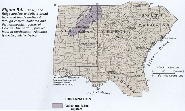
Aquifers in the Valley and Ridge physiographic province consist of permeable geologic formations within folded and faulted Paleozoic sedimentary rocks. The extent of the Valley and Ridge aquifers in Segment 6 is shown in figure 94. These aquifers are much more areally extensive in Segment 11 of this Atlas, and, accordingly, are not discussed in great detail here. The Valley and Ridge physiographic province is so named because it consists of a series of parallel valleys separated by steep to well-rounded ridges that rise from about 100 to 700 feet above the valley floors. The valleys are underlain by easily eroded rocks, and the ridges by more resistant rocks. Major streams flow down the axes of many of the valleys, and tributary streams commonly join the major streams at nearly right angles.
Sedimentary rocks of the Valley and Ridge physiographic province are mostly limestone, sandstone, and shale, with lesser dolomite, siltstone, conglomerate, coal, chert, and a few beds of hematite (iron ore). Of these, the most productive aquifers are in limestone and dolomite, which yield water from solution openings. Sandstone and chert beds also yield considerable water to wells in places. Many springs issue from both limestone and sandstone; some of the springs issuing from limestone flow at a rate of several thousand gallons per minute and are used for municipal water supplies.
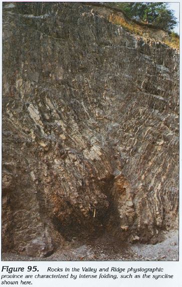
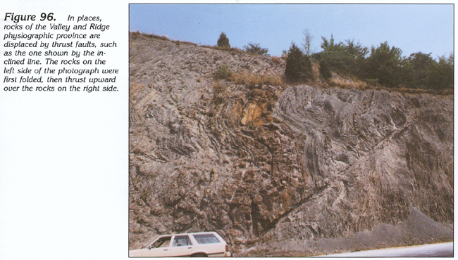
Folding in the rocks of the Valley and Ridge physiographic province varies from tightly compressed folds (fig. 95) to broad, open folds; in general, folding is tighter in the northwestern part of the province. In some places, lateral compressional forces that caused the folding exceeded the shear strength of the rock and thrust faults formed (fig. 96). Some of these thrust faults displaced the Paleozoic strata laterally as much as 5 to 10 miles. Surface traces of the larger faults extend for many miles. The folding and faulting has resulted in geologic and topographic complexity, reflected by many local ground-water flow systems.
HYDROGEOLOGIC UNITS
Rocks comprising the Valley and Ridge aquifers in Alabama and Georgia range in age from early to late Paleozoic (fig. 97). Many of the geologic formations are continuous from Alabama into Georgia. Other geologic formations change character between the two States, or even within a State. The changes are primarily facies variations, such as a transition from sandstone to limestone, or limestone to shale, and are accompanied by corresponding changes in permeability. The boundaries of aquifers and rock units are generally considered to be the same throughout the Valley and Ridge physiographic province. Because of this parallelism, aquifers are not given names; rather, the hydrologic characteristics of individual geologic formations are discussed, a practice that is followed for the Valley and Ridge aquifers in this Atlas.
Most of the Valley and Ridge aquifers consist of limestone or dolomite. Carbonate-rock units that are productive aquifers in Segment 6 include the Chickamauga, Knox, and Conasauga Groups (fig. 97), which yield 10 to 50 gallons per minute and are the source of numerous springs. Wells completed in the Tuscumbia Limestone, in combination with the Fort Payne Chert, commonly yield 20 to 30 gallons per minute. The carbonate rocks are productive aquifers primarily because of the ease with which solution openings develop in the easily dissolved limestone and dolomite. These openings, which originate as bedding planes and joints in the carbonate rocks, are enlarged by percolating, slightly acidic ground water, and become linked as a series of conduits that transmit large volumes of ground water rapidly through the carbonate rocks. Wells penetrating solution openings commonly yield 100 gallons per minute or more. Secondly, the easily eroded carbonate rocks form wide valley floors, which are favorable areas for recharge.
Geologic formations consisting of sandstone also are aquifers, but yield less water than the carbonate rocks. Much of the water from sandstone is obtained from fractures. Wells completed in the Frog Mountain Sandstone, and in sandstone beds in the Red Mountain and Rome Formations, commonly yield 10 gallons per minute.
The Fort Payne Chert also is a productive aquifer; it consists of thin-bedded, intensely fractured (thus highly permeable) chert in which the original carbonate matrix has been completely dissolved in most places. Locally, where the Floyd Shale and Weisner Quartzite are fractured, they yield sufficient water for domestic supplies. The regolith (weathered bedrock combined with soil and alluvium) developed on the Paleozoic rocks will yield sufficient water for domestic supplies practically everywhere.
GEOLOGIC STRUCTURE
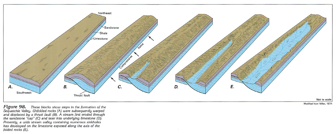
Folding has markedly affected the topography of the Valley and Ridge physiographic province and also affects the hydrologic characteristics of the rocks. The Sequatchie Valley, an isolated northeast-trending anticline that appears as the separate "finger" of Valley and Ridge aquifers in figure 94, illustrates the effect of folding. The series of schematic block diagrams shown in figure 98 illustrate the development of the Sequatchie Valley. The blocks are drawn as they would appear if viewed looking northeastward into Tennessee from a point near the Alabama-Tennessee State line.
Originally, the flatlying Paleozoic sedimentary rocks consisted of a limestone sequence overlain by shale and sandstone (fig. 98A). Folding and thrust-faulting took place as a result of compression from the southeast (fig. 98B). Most of the deformation occurred at or near the end of Paleozoic time. The Mississippian limestone sequence and the Pennsylvanian sandstone that caps it were both fractured by the folding. The fracturing increased the susceptibility of the sandstone to erosion, and a stream network soon developed along the crest of the upfolded strata (fig. 98C).
As the stream continued to erode headward and laterally, a flat plain was developed on an area of increasingly exposed carbonate rocks (fig. 98D). Continued erosion both widened and lengthened the valley into its present configuration (fig. 98E). Once the limestone was exposed, dissolution accelerated the valley-forming process. Sinkholes first developed near the headwaters of the stream (fig. 98D) and subsequently formed along the floodplain (fig. 98E). The tributary streams that join the trunk stream at almost right angles are partially controlled by fractures developed perpendicular to those trending along the center of the fold.
GROUND-WATER FLOW
The general flow pattern in folded rocks is typified by that of the Sequatchie valley (fig. 99). The cap of Pennsylvanian clastic rocks and coal beds has been completely eroded from the axis of the valley, exposing a wide band of Mississippian limestone that is displaced by a thrust fault.
The Valley and Ridge aquifers are recharged by precipitation falling on outcrop areas. The precipitation percolates downward through the Pennsylvanian rocks primarily as flow along steeply inclined fractures. Shale beds retard the vertical flow and cause much of the water to move laterally through beds of sandstone and conglomerate until it emerges as springs along the face of steep slopes. A small proportion of the water leaks downward across shale beds and into the Mississippian limestone, where it is joined by ground water that originated as precipitation that fell directly on the limestone exposed along the valley floor. Water in the limestone moves mostly along solution conduits developed by dissolution of the rock along joints and bedding planes. Eventually, the water from the limestone discharges into surface streams as baseflow.
RELATION OF ROCK TYPE AND WELL YIELD
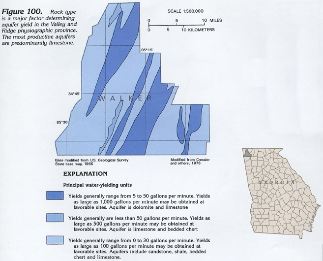
Most of the water in the aquifers of the Valley and Ridge physiographic province flows through fractures or solution openings, rather than through pore spaces within the rock. The number and size of fractures and solution openings, coupled with their degree of interconnection, determines hydraulic properties and controls well yield. The interconnection of these large-scale openings, which are most common at depths of less than 350 feet, varies directly with the type of rock. The relation of well yield and rock type is illustrated by figures 100 and 101.
The relative yield of the principal water-yielding units in Walker County, Ga., is shown in figure 100 by bands of color that trend northeast. The geology of Walker County is shown in figure 101. The areas of maximum well yields in figure 100 coincide with limestone and dolomite units of the Knox Group and the Newala Limestone in figure 101. Areas of maximum well yields in figure 100 generally are coincident with rocks of the Chickamauga Group and Silurian and younger rocks in figure 101. Intermediate yields are obtained from the Fort Payne Chert (fig. 101), but only where the topography developed on it is nearly level. Like other productive aquifers, the Fort Payne Chert does not yield as much water where it is exposed as thin bands in steep valley walls, because the recharge area of the aquifer is small in such a topographic setting.
GROUND-WATER QUALITY
The quality of the water in the Valley and Ridge aquifers is somewhat variable, but generally is satisfactory for municipal supplies and other purposes. Most of the water in the upper parts of the aquifers is not greatly mineralized and is suitable for most uses without treatment. Dissolved-solids concentrations average about 140 milligrams per liter, and chloride concentrations average about 4 milligrams per liter. Iron, however, commonly is present in large concentrations, in some places exceeding the limit of 300 micrograms per liter recommended for drinking water. Iron concentrations of as much as 20,000 micrograms per liter have been measured in water from some wells completed in Valley and Ridge aquifers. Locally, the water contains large sulfate concentrations.
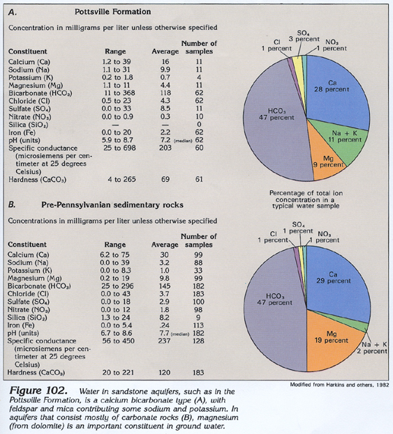
Water in the Valley and Ridge aquifers is mostly a calcium bicarbonate type (fig. 102A). Slight differences exist between water from sandstone of the Pottsville Formation of Pennsylvanian age, which supplies a few domestic wells along scattered ridge tops in the area, and water from the pre-Pennsylvanian, predominantly carbonate-rock, aquifers from which most of the water is obtained. Magnesium concentrations are greater in water from the pre-Pennsylvanian rocks (fig. 102B) because of the presence of dolomite in many of the aquifers. Concentrations of sodium and potassium are greater in water from the Pottsville Formation due to the presence of feldspar and mica in that unit.
FRESH GROUND-WATER WITHDRAWALS
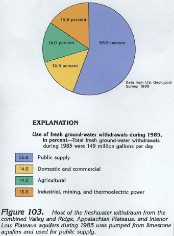
Total withdrawals of freshwater from the combined Valley and Ridge, Appalachian Plateaus, and Interior Low Plateaus aquifers during 1985 were about 149 million gallons per day. Withdrawals are not categorized by rock type, but most of the pumpage was from limestone aquifers. About 83 million gallons per day was withdrawn for public supply use, primarily by small communities (fig. 103). The remaining pumpage was almost equally divided among domestic and commercial (about 22 million gallons per day); agricultural (about 21 million gallons per day); and industrial, mining, and thermoelectric-power uses (about 23 million gallons per day).