
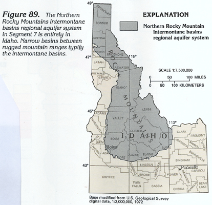
The basins that compose the Northern Rocky Mountains intermontane basins regional aquifer system (fig. 89) are geologically and hydrologically similar to the basins of the Great Basin regional aquifer system, except they are typically much narrower and receive more precipitation. The Northern Rocky Mountains intermontane basins regional aquifer system extends into Montana; that part of the system is described in Segment 8 (Chapter I) of this Atlas. In Segment 7, the aquifer system is located entirely in Idaho.
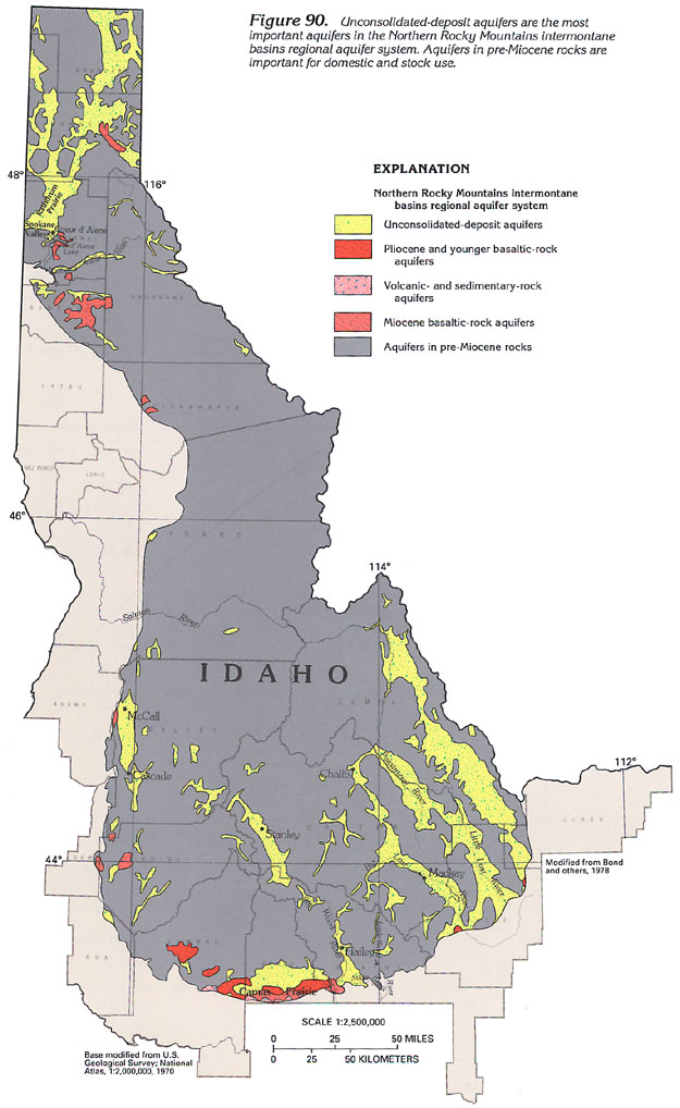
Although some of the intermontane basins, such as the Big Lost River basin in Custer and Butte Counties (fig. 90), have been developed for irrigated agriculture, development in most of the basins is related to the lumber and mining industries, recreational activities, and livestock raising. Except for lowland areas, a large part of each intermontane basin is rugged, uninhabited public land where demand for ground water is small. Ground water in these basins is used chiefly for domestic and commercial, and agricultural (primarily livestock watering) purposes.
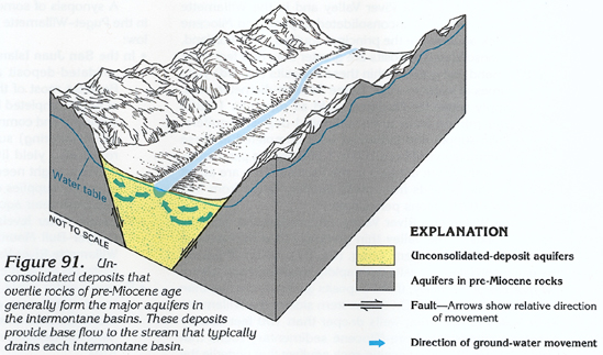
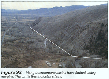
Unconsolidated-deposit aquifers are the most important aquifers in the intermontane basins, but in places, the underlying Pliocene and younger basaltic rocks or Miocene basaltic rocks compose important aquifers (fig. 90). In addition, aquifers in pre-Miocene rocks yield water to many wells or springs for domestic and commercial purposes. Unconsolidated deposits in the basin lowlands range from clay and fine sand to coarse sand and gravel. Where increasing proportions of clay are intermixed with the coarse-grained deposits, permeability is decreased. Faulted valley margins might affect ground-water movement (figs. 91 and 92). Depth to the water table ranges from a few feet below land surface in the lowlands near streams to several hundred feet below land surface in alluvial fans close to the mountain fronts.
A synopsis of some aspects of the ground-water system in selected
Northern Rocky Mountains intermontane basins (fig. 90) is presented
below:
· Unconsolidated-deposit aquifers in Boundary and Bonner
Counties yield small volumes of water to wells for public-supply,
domestic and commercial, and agricultural (primarily livestock
watering) purposes. The unconsolidated deposits are chiefly fine
grained, or, if coarse grained, they contain a matrix of clay.
In Boundary County, most wells range from 10 to 200 feet deep.
Depth to water ranges from flowing to more than 100 feet below
land surface. In Kootenai County, wells completed in unconsolidated
deposits in the Coeur d'Alene River Valley can yield as much as
3,000 gallons per minute. The thickness of the deposits ranges
from a few feet near the Kootenai-Sho-shone County boundary to
more than 400 feet at the mouth of the Coeur d'Alene River where
it enters Coeur d'Alene Lake. In places, Miocene basaltic rock
that underlies the unconsolidated deposits will yield small to
moderate volumes of water to wells for domestic and commercial
and agricultural (primarily livestock watering) purposes.
· In the southern part of Bonner County and in Kootenai
County, coarse-grained glacial outwash composes the Rathdrum Prairie
unconsolidated-deposit aquifer. The aquifer consists of coarse
sand and gravel that are more than 510 feet thick locally. Yields
are as much as 3,000 gallons per minute to wells used for public-supply,
domestic and commercial, and agricultural (primarily livestock
watering) purposes. Most wells range from 100 to 500 feet deep,
and depth to water ranges from flowing to more than 400 feet below
land surface. In places, some water is withdrawn from the underlying
Miocene basaltic rocks. The Rathdrum Prairie aquifer is extremely
important for recharging the Spokane Valley aquifer in northeastern
Washington just west of the Idaho-Washington border. During the
summer months, recreational activities attract thousands of tourists
to the area and intensify demands on the ground-water system.
· In Benewah County, Miocene basaltic-rock aquifers are
important sources of water for domestic and commercial purposes.
Some of the water is obtained from springs that are scattered
throughout much of the county. Most wells, which are shallow,
range from 15 to less than 100 feet deep. Yields to wells are
usually quite small and range from 5 to 15 gallons per minute.
· Valleys in Shoshone, Clearwater, and Idaho Counties contain
generally thin, narrow aquifers in unconsolidated deposits. Most
of the deposits are too small to show at the scale of figure 90.
These aquifers yield water to wells chiefly for public-supply
and domestic and commercial purposes; some of the water might
be used for agricultural (primarily livestock watering) purposes,
but if so, the amount is extremely small. Aquifers in pre-Miocene
rocks also are used for water supply in many places. Because much
of each county is uninhabited, demand for ground water is small.
· Valley County contains the recreation-oriented towns
of Cascade and McCall, which experience large population increases
and subsequent increases in ground-water demand during the summer.
Unconsolidated-deposit aquifers yield water to wells for public-supply,
domestic and commercial, and agricultural (primarily livestock
watering) purposes; most agricultural water needs, however, are
met by using surface-water sources.
The unconsolidated deposits consist of fine- to coarse-grained
rocks, which are chiefly of glacial origin; their permeability
is extremely variable. Yields to wells range from 1 to 500 gallons
per minute. In places, aquifers in Miocene basaltic or pre-Miocene
rocks yield water for domestic and commercial purposes.
· Lemhi and Custer Counties contain large, wide valleys
filled with unconsolidated deposits to unknown depths. Except
for those deposits in or near stream channels, most deposits contain
a large percentage of clay or silt, and permeability is generally
low. Some deposits in or near streams yield as much as 3,850 gallons
per minute to wells. Elsewhere, the yields are much lower. Some
water is withdrawn from aquifers in pre-Miocene rocks. The water
withdrawn is used for public-supply, domestic and commercial,
and agricultural purposes. Wells range in depth from less than
10 to more than 500 feet. Depth to water ranges from flowing to
more than 500 feet below land surface. Wells in the lowlands are
shallowest, and those on alluvial fans near the valley margins
are generally deepest. The Stanley area in southwestern Custer
County experiences an extremely large increase in population during
the summer owing to recreational activities that also increase
demands on the area's ground-water system.
In the Big Lost River Valley and the Challis area, ground water
is used for public-supply, domestic and commercial, and agricultural
(primarily irrigation and livestock watering) purposes. Much of
Custer and Lemhi Counties is uninhabited and extremely rugged.
· In Boise County, most ground water is withdrawn for public-supply,
domestic and commercial, and agricultural (primarily livestock
watering) purposes. Although unconsolidated-deposit aquifers are
the most important, aquifers in Miocene basaltic and pre-Miocene
rocks are used locally. Yields to wells are usually small, but
some wells in unconsolidated deposits yield as much as 500 gallons
per minute. Ground water in Elmore County is withdrawn from unconsolidated-deposit
and Pliocene and younger basaltic-rock aquifers, and aquifers
in pre-Miocene rocks for domestic and commercial and agricultural
(primarily livestock watering) purposes. In the western part of
Camas Prairie, ground water is used for agricultural (primarily
irrigation) purposes.
· Camas County contains a large, wide valley filled with
unconsolidated deposits that are as much as 1,125 feet thick.
The unconsolidated deposits and Pliocene and younger basaltic
rocks yield water to wells for public-supply, domestic and commercial,
and agricultural (primarily irrigation) purposes. Most ground
water in the county is used for agricultural (primarily irrigation)
purposes. Wells range from less than 50 to as much as 1,125 feet
deep; however, many wells in Camas Prairie are less than 50 feet
deep. Depth to water ranges from flowing to about 200 feet below
land surface. Most shallow wells are completed in unconfined aquifers
and deeper wells are completed in confined aquifers. Yields of
wells in the county are variable and range from less than 100
to 2,000 gallons per minute.
· In Blaine County, ground water is withdrawn from unconsolidated-deposit
aquifers in the Hailey area for public-supply, domestic and commercial,
and agricultural (primarily irrigation and livestock watering)
purposes. The unconsolidated deposits were emplaced as alternating
layers of fine- and coarse-grained material. Confined aquifers
are common in the southern end of the Big Wood River Valley and
the Silver Creek area. Wells that range from 30 to more than 500
feet deep yield from less than 10 to more than 5,000 gallons per
minute. Depth to water ranges from flowing to 150 feet below land
surface. Most deeper wells flow at the land surface. In the Little
Wood River Valley, there are only a few wells, and depth to water
in these wells ranges from less than 10 to 130 feet below the
land surface. Blaine County contains uninhabited, topographically
rugged areas where there are no demands on the ground-water system.
· Unconsolidated deposits fill the Big Lost River Valley
in Butte and Custer Counties to as much as 5,500 feet deep. The
uppermost 500 feet of the deposits is the most permeable. Unconsolidated-deposit
aquifers yield water to wells for most public-supply, domestic
and commercial, and agricultural purposes. However, aquifers in
pre-Miocene rocks provide small volumes of water to wells. Well
depths range from less than 10 to more than 500 feet. Depth to
water ranges from flowing to more than 500 feet below land surface.
Yields of wells range from less than 10 to more than 2,800 gallons
per minute. The permeability of the unconsolidated-deposit aquifers
is variable. Confined aquifers are present locally. The Big Lost
River Valley is an important recharge source for the eastern Snake
River Plain aquifer system. The Little Lost River Valley is similar
to the Big Lost River Valley, except that it receives less annual
recharge to underlying aquifers. Because the Little Lost River
Valley is sparsely populated, most water is used for agricultural
purposes. Depth to water ranges from less than 10 to 280 feet
below land surface. Yields of wells range from 10 to 2,500 gallons
per minute. Butte and Custer Counties contain uninhabited, topographically
rugged areas where there are no demands on the ground-water system.
· In Clark County, the large area of unconsolidated deposits
is virtually unused. Although the ground-water potential might
be good, little is known of ground-water conditions in this part
of Clark County. The area is sparsely populated.
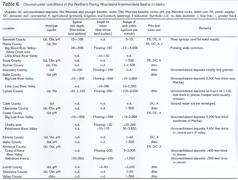
Information pertaining to ground-water conditions in the Northern
Rocky Mountains intermontane basins is summarized by county in
table 6.