Pliocene and younger basaltic-rock aquifers (fig. 26) consist primarily of thin, basaltic lava flows and beds of basaltic ash, cinders, and sand. The aquifers are most productive in the Snake River Plain of Idaho. These aquifers yield freshwater that is used mostly for agricultural (primarily irrigation) purposes.
Most of the Pliocene and younger basaltic rocks were extruded as lava flows from numerous vents and fissures concentrated along rift or major fault zones in the Snake River Plain. The lava flows spread for as much as about 50 miles from some vents and fissures. Overlapping shield volcanoes that formed around major vents extruded a complex of basaltic lava flows in some places (fig. 27). Thick soil, much of which is loess, covers the flows in many places. Where exposed at the land surface, the top of a flow typically is undulating and nearly barren of vegetation (fig. 28). The barrenness of such flows contrasts markedly with those covered by thick soil where agricultural development is intensive (fig. 29).
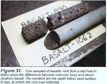
The permeability of the Pliocene and younger basaltic rocks is dependent on several factors: (1) the cooling rate of the basaltic lava flows, (2) the thickness of the basaltic lava flows, and (3) the number and character of interflow zones (permeable zones at the tops and the bottoms of flows). The cooling rate was most rapid when flows entered water and formed pillow basalt (fig. 30). These flows have numerous interconnected open spaces at their tops and bottoms. Some of these flows have a fragmental texture similar to that of sand and gravel or of cobbles and boulders. Where flows did not enter water, cooling was slower, but the tops and the bottoms of the flows cooled much more rapidly than did their centers. Open spaces, such as vesicles (fig. 31), which are voids between rock fragments, and most importantly, fractures and joints between blocks of basalt, developed in the upper and lower zones of the flows (fig. 32) as the tops and the bottoms cooled while the centers continued to flow. In contrast, few open spaces developed in the centers of the flows where cooling was slowest (figs. 31 and 32). When entire flows cooled extremely slowly, few open spaces developed even in the upper and lower zones of the flows. These flows form dense zones within more permeable zones, and wells that penetrate these dense zones commonly yield little or no water (fig. 33).
The thickness of the individual flows is variable; the thickness of flows of Holocene and Pleistocene age averages about 25 feet, whereas that of Pliocene-age flows averages about 40 feet. The thinner the flows are, the greater the possibility for the transmission of some water through the centers of the flows and the greater the number of permeable interflow zones.
The interflow zones contain most of the interconnected open spaces in the basaltic rocks. In some places, the interflow zones are separated from each other by layers of unconsolidated deposits (fig. 34) that were emplaced during the time between flows or between eruptive episodes. Where the unconsolidated deposits are fine grained (soil or lakebed sediments), the deposits form confining units and can create perched water-table conditions. Where the unconsolidated deposits are coarse grained (stream gravel), the deposits enhance the permeability of the adjacent interflow zones.
The permeability of the Pliocene and younger basaltic rocks is greatest in areas that have sequences of flows that cooled rapidly, are thin, have numerous interflow zones, and have few interbedded layers of fine-grained unconsolidated deposits. Such an ideal sequence is shown in figure 35; this idealized sequence represents four eruptive episodes labeled A (oldest) through D (youngest). During each eruptive episode, as many as seven flows were extruded. After four flows were extruded during eruptive episode A, parts of flows 3 and 4 were eroded, and stream gravel was subsequently deposited on part of flow 3. This stream gravel forms a zone of substantial permeability. This gravel was subsequently covered by flow 1 of episode B. At the end of eruptive episode B, volcanic activity ceased long enough to allow soil to develop on flow 6. This soil forms a confining zone of minimal permeability. During episode C, flow 6 was extruded into water-forming pillow basalt; the resulting interflow zone between flows 5 and 6 is extremely permeable. In contrast to the zones between flows of episodes A and B or B and C, there is no evidence of either erosion and deposition or soil formation during the time between the extrusion of the last flow (flow 7) of episode C and the first flow (flow 1) of episode D; these episodes can be distinguished only by subtle textural or mineralogical changes in the respective flows.
The water level in some wells completed in Pliocene and younger basaltic-rock aquifers is affected by changes in atmos-pheric pressure where the overlying unsaturated zone in the Pliocene and younger basaltic rocks contains zones of dense basalt that function as semiconfining units (fig. 36). When the atmospheric pressure is less than the air pressure in the unsaturated zone below the semiconfining units, the water level in the wells will rise, and air might be expelled (fig. 36). Conversely, when the atmospheric pressure is greater than the air pressure in the unsaturated zone below the semiconfining units, the water level in the wells will decline, and air might be drawn in. Water levels in such wells might fluctuate several tenths of a foot in response to changes in atmospheric pressure (fig. 37). The exchange of air continues until equilibrium is reached between the atmospheric pressure and the air pressure in the unsaturated zone below the semiconfining units. If a person is standing adjacent to a well during a period of large differential, the force of the air being expelled or drawn in could be great enough to blow off the person's hat.
Wells completed in Pliocene and younger basaltic-rock aquifers commonly have specific-capacity values that range from 500 to 1,000 gallons per minute per foot of drawdown. In the Snake River Plain of Idaho, the transmissivity of these aquifers, which was estimated from aquifer tests and digital simulation of the upper 200 feet of the aquifers, ranges from about 100,000 to about 1 million feet squared per day. The estimated transmissivity for the entire thickness (about 4,000 feet) of these aquifers commonly ranges from about 10,000 to about 2,400,000 feet squared per day; the maximum estimated transmissivity is about 4 million feet squared per day.
Near the margins of their outcrop area, the Pliocene and younger basaltic-rock aquifers are underlain by unconsolidated-deposit, volcanic- and sedimentary-rock, and Miocene basaltic-rock aquifers and aquifers in pre-Miocene rocks. Most of the underlying aquifers are much less permeable than the Pliocene and younger basaltic-rock aquifers. The types of rocks or aquifers underlying the Pliocene and younger basaltic-rock aquifers in the central part of their outcrop area are unknown.