
The Snake River Plain regional aquifer system underlies a large,
crescent-shaped lowland that extends from near the western boundary
of Yellowstone National Park in eastern Idaho to the Idaho-Oregon
border where the Snake River enters Hells Canyon (fig.
52). The northern and southern boundaries of the Snake River
Plain generally coincide with the contact between unconsolidated
deposits or Pliocene and younger basaltic rocks in the lowland
and older rocks in adjacent highlands.
Early ground-water studies concentrated only on that part of the plain east of the Thousand Springs area and north of the Snake River, an area of about 9,600 square miles. A regional study, which was begun in 1979 by the U.S. Geological Survey, focused on the entire 15,600 square miles of the Snake River Plain. During 1980, about 3.1 million acres on the plain was irrigated-about 2 million acres with surface water, about 1 million acres with ground water, and about 100,000 acres with a combination of surface and ground water. About 5,300 wells provided ground water for irrigation.
Abrupt changes in hydrogeologic conditions along the Snake River between Salmon Falls Creek and King Hill, Idaho, make it feasible to discuss the regional aquifer system by area-the eastern and the western plains (fig. 53). In the eastern plain, the regional aquifer system consists primarily of Pliocene and younger basaltic rocks with some overlying and interbedded unconsolidated deposits; in the western plain, the aquifer system consists primarily of unconsolidated deposits with some Pliocene and younger basaltic rocks (fig. 53).
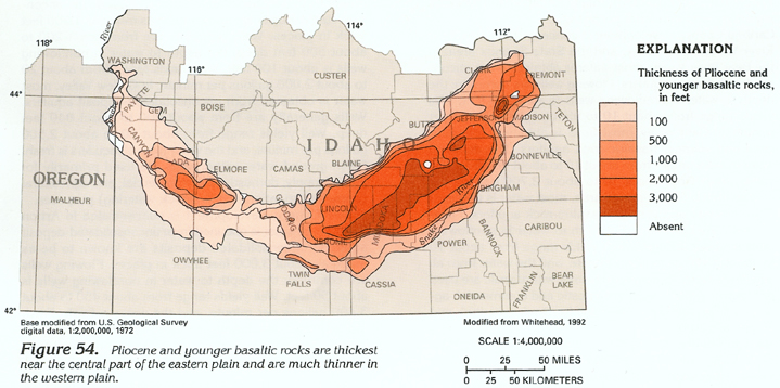
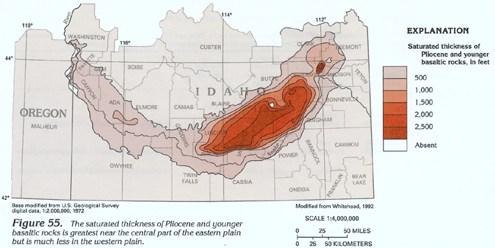
The Pliocene and younger basaltic rocks are from 1,000 to 2,000 feet thick in large areas of the eastern plain but are that thick in only a small part of the western plain (fig. 54). Similarly, the saturated thickness of Pliocene and younger basaltic rocks is from 500 to greater than 1,000 feet in large areas of the eastern plain but is that thick in only a small part of the western plain (fig. 55). Because there are few deep wells in the eastern plain, the thickness of Pliocene and younger basaltic rocks in areas where these rocks range from 1,000 to more than 3,000 feet thick (figs. 54 and 55) was estimated by using electrical resistivity surveys (the maximum thickness estimated was 5,500 feet). Consequently, some older volcanic rocks (including basalt and silicic volcanic rocks) might be included with Pliocene and younger basaltic rocks, particularly in areas where the thickness exceeds 1,000 feet. This is also true where the Pliocene and younger basaltic rocks are shown as thin (less than 100 feet thick) or absent along the north-central and northeastern margins of the plain (figs. 54 and 55).
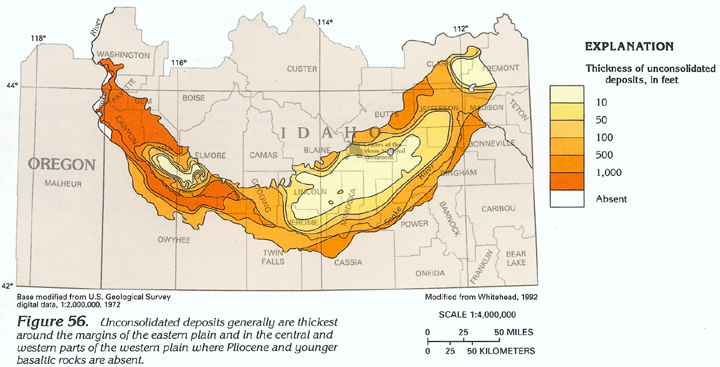
The aggregate thickness of unconsolidated deposits-those overlying, interbedded with, and underlying Pliocene and younger basaltic rocks (fig. 56) was determined primarily from drillers' logs. The unconsolidated deposits have a thickness pattern opposite that of the Pliocene and younger basaltic rocks; the unconsolidated deposits are much thicker in the western plain than in the eastern plain and are as much as about 5,500 feet thick near the northwestern tip of the western plain. In the central part of the eastern and western plains, most wells penetrate only the upper part of the Pliocene and younger basaltic rocks. In these areas, therefore, the thickness of the unconsolidated deposits primarily represents deposits that overlie the Pliocene and younger basaltic rocks; much of this thickness represents soil that has developed on the Pliocene and younger basaltic rocks. In some places, such as parts of Craters of the Moon National Monument, virtually no soil has developed on the youngest basaltic rocks that were extruded only about 2,000 years ago.
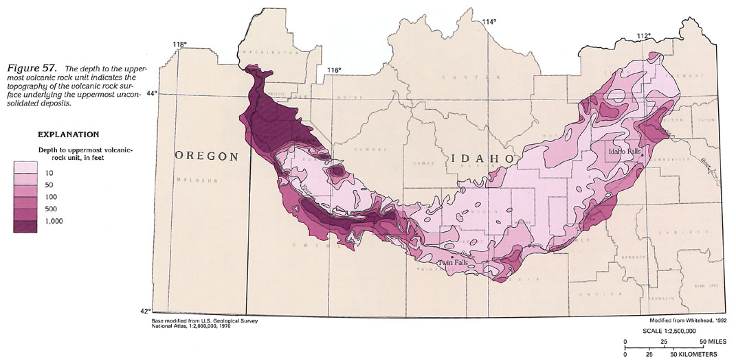
The topography of the volcanic rock surface underlying the uppermost unconsolidated deposits is indicated by figure 57, which shows the depth to the uppermost volcanic rocks. Pliocene and younger basaltic rocks are the shallowest volcanic rocks throughout much of the entire Snake River Plain. Miocene basaltic rocks and silicic volcanic rocks are the shallowest volcanic rocks, primarily near the margins of the eastern plain and in the southern and northwestern parts of the western plain. The canyonlike troughs in the volcanic rock surface in the western plain are the result of the complete erosion of near-surface, thin layers (generally less than 100 feet thick) of Pliocene and younger basaltic rocks that once overlaid thick sequences of unconsolidated deposits.
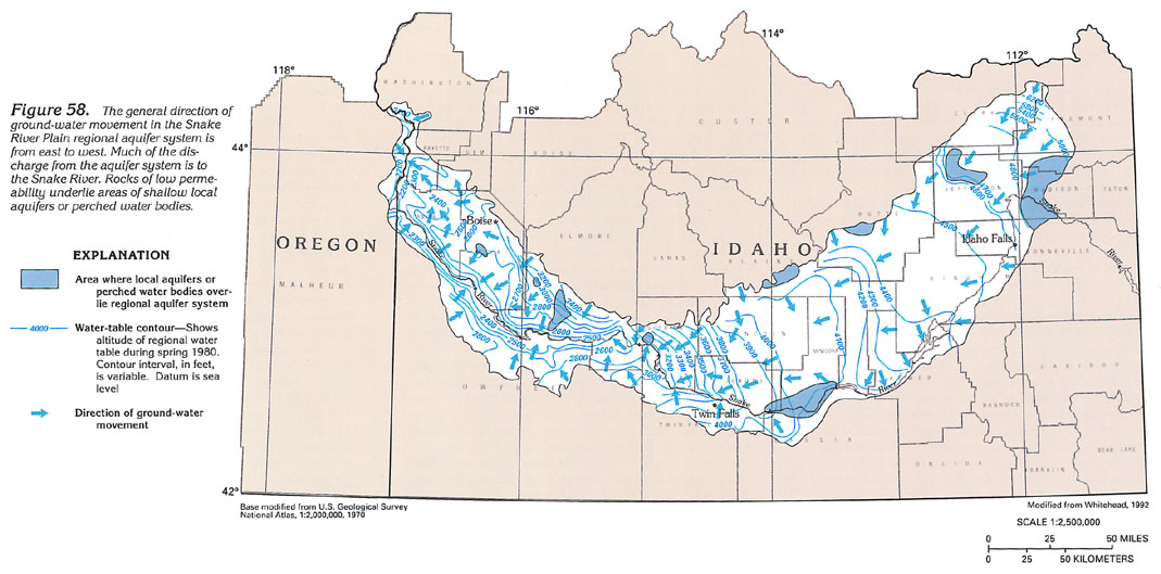
The configuration of the regional water table of the aquifer system (fig. 58) generally parallels the configuration of the land surface of the Snake River Plain; that is, the altitude of the water table is greatest in the extreme eastern part of the plain and is least in the Hells Canyon area along the Idaho-Oregon border. Upstream bending of the water-table contours where they cross the Snake River shows the places where the aquifer system is discharging to the river. The water-table contours shown in figure 58 were based on water levels measured in about 1,600 wells during spring 1980. In a general way, the configuration of and the spacing between contours indicate changes in the geologic and hydrologic character of the aquifer system and show the direction of horizontal ground-water movement at the water table. The increasing space between contours generally indicates more permeable or thicker parts of the aquifer. Conversely, the narrowing space indicates less permeable or thinner parts of the aquifer. Hydraulic head must increase to move the same volume of water through the less permeable or thinner parts of the aquifer system. Estimates of the depth to the regional water table can be made by subtracting the altitude of a water-table contour at a given point from the altitude of the land surface at the same point.
Areas where shallow local aquifers or perched water bodies
overlie the regional aquifer system are shown in figure 58. Water
levels in these areas are higher than those in the regional aquifer
system. Other such areas might exist but are too small to show
in figure 58. These areas are underlain by rocks that have extremely
low permeability.
EASTERN PLAIN
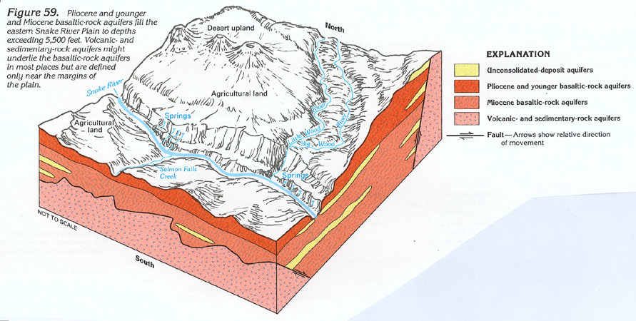
Multiple thin flows of Pliocene and younger basaltic rocks that
are interbedded with unconsolidated deposits form the Snake River
Plain regional aquifer system in the eastern plain. Pliocene and
younger basaltic-rock aquifers predominate in the central part
of the plain; unconsolidated-deposit aquifers predominate along
the margins of the plain (figs. 59
and 60). Miocene basaltic-rock aquifers
underlie the Pliocene and younger aquifers in part of the plain
(fig. 59) but are used as a source
of water only near the margins of the plain. In some places, silicic
volcanic rocks of the volcanic- and sedimentary-rock aquifers
underlie the Miocene basaltic-rock aquifers along the margins
of the plain (fig. 59); in other
places, aquifers in pre-Miocene rocks are along the plain's margins
(fig. 60).
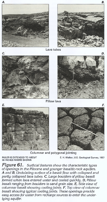
Generally, the regional aquifer system in the eastern plain is an unconfined system, although dense, unfractured basalt and interbedded clay layers cause semiconfined and confined conditions in places. Permeability of the Pliocene and younger basaltic-rock aquifers is extremely variable, as indicated by the considerable range in the size of openings present in outcrops (fig. 61). Individual basalt flows average about 25 feet in thickness; extremely permeable zones at the tops and the bottoms of flows range in thickness from less than 1 to about 10 feet. In places, permeable zones between flows or at the top of a flow might be filled with fine-grained unconsolidated deposits that decrease the permeability of the zones. The central parts of most Pliocene and younger flows are dense and almost impermeable. Wells completed in Pliocene and younger basaltic-rock aquifers generally penetrate numerous flows to obtain water from many permeable zones. Deeply buried flows of Miocene basaltic rocks typically are thicker and less permeable than flows of Pliocene and younger basaltic rocks.
Much of the recharge in the eastern plain originates as precipitation on the highlands adjacent to the plain, chiefly on the northern side. Precipitation falling on the plain itself accounts for less than 10 percent of the total recharge. Infiltration of surface water diverted from the Snake River for irrigation of land near the river accounts for about 67 percent of the total recharge. Rainfall and snowmelt on the plain infiltrate quickly to the water table because of many surface or near-surface openings (fig. 61) in Pliocene and younger basaltic rocks; similar openings at depth provide conduits for water movement.
Much of the discharge from the eastern plain is through springs. Two major spring discharge areas are near the American Falls Reservoir and the Thousand Springs area near Twin Falls, Idaho. In the American Falls area, springs and flowing wells are common because permeable basalt, gravel, and sand units upstream grade into less permeable lakebeds in the vicinity of the reservoir. The result is a series of springs and seeps at or near river level that discharge about 1.1 million gallons per minute to the Snake River and the American Falls Reservoir. At the northern end of the American Falls Reservoir, lakebeds (mainly silt and clay) create ideal confining conditions and wells that range from 200 to 400 feet deep flow at the land surface. Aquifer permeability decreases markedly southwestward along both sides of the reservoir because the percentage of clay increases.
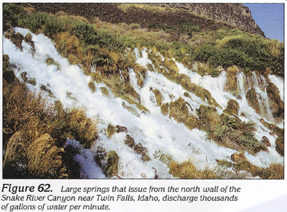
In the Thousand Springs area near Twin Falls, the largest springs issue from saturated pillow basalt (also referred to as pillow lava) that fills ancestral canyons of the Snake River, which were truncated by the present canyon (fig. 62). Pillow basalt formed in stream channels upstream from temporary dams that were created by basalt flows. Water downstream from the temporary dam drained away, and dense basalt formed in the abandoned channel as it filled with lava (fig. 63). Upstream from the temporary dam, the channel became a temporary lake. As lava continued to pour into the lake, the lava exploded violently as a result of rapid cooling and formed fragments of basalt that ranged in size from sand to huge boulders. The result was a permeable mix of basaltic sand, gravel, and boulders that are able to store and transmit large volumes of ground water.
Many springs issue from the north wall of the Snake River Canyon (fig. 59); some of these springs are as much as 200 feet above river level. Early in the development of the water resources in the area, water from the springs was recognized as having potential for hydroelectric power generation, irrigation, and aquaculture (fish farming). Since then, development of the springs has increased significantly.
Wells in the eastern plain withdraw large volumes of water
primarily for agricultural (chiefly irrigation) purposes. Ground
water in the eastern plain also is used for public-supply, domestic
and commercial (including aquaculture), and industrial purposes.
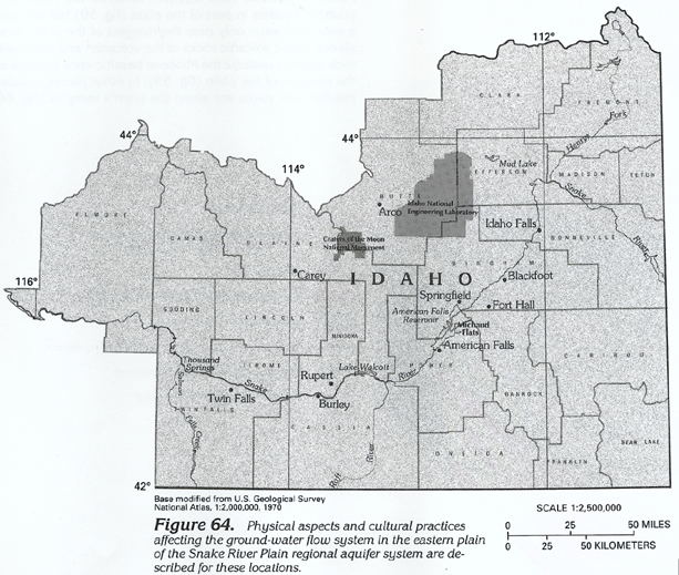
A synopsis of some aspects of the ground-water system in the eastern
plain (fig. 64) is presented below:
· In the area between Twin Falls and Salmon Falls Creek
in Twin Falls County, the water table has risen as much as 200
feet as a result of recharge from surface-water irrigation. Drains
and tunnels have been constructed to alleviate some of the waterlogging
problems.
· In the area between Twin Falls and the Raft River, which
is chiefly in Cassia County, large tracts of land have been developed
for irrigation with ground water. Declining water levels in this
part of the Snake River Plain prompted the State of Idaho to designate
several Critical Ground-Water Areas; these are areas where no
additional wells can be drilled. During 1956, most wells withdrawing
water from unconsolidated-deposit aquifers were from 50 to 500
feet deep, and depth to water ranged from flowing to 150 feet
below land surface. Since then, many wells have been deepened
to accommodate declining water levels, and during 1988, most wells
were from 500 to about 1,500 feet deep. Some wells withdraw water
from underlying Pliocene and younger basaltic-rock aquifers. Depth
to water during 1988 ranged from flowing to about 500 feet below
land surface. Waterlogging problems that resulted from irrigation
in the Rupert area in Minidoka County, which is on the northern
side of the Snake River, necessitated the construction of drains
to lower the water levels in fine-grained unconsolidated-deposit
aquifers.
· In the Springfield area in Bingham County, which is at
the northern end of the American Falls Reservoir, layers of fine-grained
unconsolidated deposits (lakebed sediments) composed chiefly of
clay confine water in unconsolidated-deposit aquifers composed
of interbedded sand and gravel. The sequence of clay layers and
interbeds is as much as 750 feet thick.
· Along the eastern side of the Snake River and near the
river on the western side in the Fort Hall-Blackfoot area of Bannock
and Bingham Counties, unconsolidated-deposit aquifers that consist
of coarse sand and gravel yield water to domestic and stock wells,
but cinder zones in the underlying Pliocene and younger basaltic-rock
aquifers yield water to most irrigation wells. The sand and gravel
extends upstream along the Snake River channel to the junction
of Henrys Fork and the Snake River in Madison County. In this
reach, the Snake River loses a substantial volume of water to
the underlying sand and gravel. Much of the water is discharged
later from springs at and near the northern end of the American
Falls Reservoir.
· The Mud Lake area in Jefferson County is a large, shallow
basin underlain by clay (lakebed sediments), unconsolidated-deposit
aquifers that consist of sand and gravel, and Pliocene and younger
basaltic-rock aquifers. In most places, water is less than 50
feet below the land surface. Groups of between 10 and 12 wells
pump water into canals for irrigation use. These wells range from
80 to 160 feet deep, and individual well yields range from 2,000
to 9,000 gallons per minute. In addition to the groups of wells,
hundreds of individual irrigation and domestic wells are used
in the area; yields of these wells range from 10 to 9,000 gallons
per minute. Wells immediately south of Mud Lake are as deep as
400 feet, and depth to water is about 250 feet below land surface.
· In Blaine and Butte Counties, unconsolidated-deposit
aquifers that are interlayered with Pliocene and younger basaltic-rock
aquifers are present at the mouths of all drainage basins that
are tributary to the Snake River Plain. In those areas, depth
to water increases rapidly southward with increasing distance
from the boundary of the plain. The rapid increase is caused by
water moving from fine-grained unconsolidated-deposit aquifers
into permeable Pliocene and younger basaltic-rock aquifers. For
example, immediately south of Arco, wells as much as 1,000 feet
deep are completed in Pliocene and younger basaltic-rock and interbedded
unconsolidated-deposit aquifers; generally, depth to water is
less than 500 feet below the land surface. A few miles farther
south, deep wells penetrate only Pliocene and younger basaltic-rock
aquifers; depth to water is as much as 1,000 feet below the land
surface. Southwest of Craters of the Moon National Monument in
Blaine County, depth to water is as much as 1,235 feet below land
surface.
· Much of the central plain, which is primarily devoid
of vegetation, consists of Pliocene and younger basaltic-rock
aquifers, some of which are less than 2,000 years old. A thin,
windblown soil cover supports sparse grass and sagebrush in places.
The lack of economic opportunities, extensive areas of public
land, and remoteness restrict ground-water development.
· Areas on the Snake River Plain where water can pond on
the land surface are common because of the irregular surface that
was formed by coalescing basalt flows. The problem of ponded water
in irrigated and urban areas was resolved by drilling disposal
wells through which the water could drain into an underlying permeable
zone. Wells also were used to dispose of excess irrigation water
and sewage. Laws restricting the use of disposal wells were enacted
during the early 1970's.
· Hydraulic properties of Pliocene and younger basaltic-rock
aquifers in the eastern plain are highly variable and, in most
places, poorly defined. The most detailed subsurface investigations
have been made at the Idaho National Engineering Laboratory (INEL)
site in the central part of the eastern plain. A 10,000-foot exploratory
hole was drilled on the site during the late 1970's. The most
permeable section is the upper 1,200 feet in Pliocene and younger
basaltic rocks of the Snake River Plain regional aquifer system.
The next 1,100- and 7,700-foot sections consist of Miocene basaltic
rocks and undifferentiated volcanic and sedimentary rocks, respectively,
of low permeability. The hole bottomed in silicic volcanic rocks.
Numerous aquifer tests have been made at the INEL site and elsewhere
on the eastern plain to determine the hydraulic properties of
the various rock types. Aquifer tests and computer simulation
indicate that the transmissivity of the upper 200 feet of the
Pliocene and younger basaltic-rock aquifers ranges from 104,000
to 1.8 million feet squared per day. Yields of wells completed
in the Pliocene and younger basaltic-rock aquifers are among the
largest in the Nation. Irrigation wells open to less than 100
feet of the aquifers yield as much as 7,000 gallons per minute
with only a few feet of drawdown. Well yields that range from
2,000 to 3,000 gallons per minute are common. The Pliocene and
younger basaltic-rock aquifers generally yield much more water
than do the interbedded unconsolidated-deposit aquifers. In places
where the Pliocene and younger basaltic-rock aquifers consist
primarily of dense basalt, however, well yields are extremely
small.
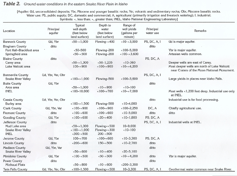
Information pertaining to ground-water conditions in the eastern
plain is summarized by county in table
2.
WESTERN PLAIN
In the western plain, the Snake River Plain regional aquifer system
(fig. 53) consists chiefly of unconsolidated-deposit aquifers
with some Pliocene and younger basaltic-rock aquifers (fig.
65). Pliocene and younger basaltic-rock aquifers are the major
aquifers near Mountain Home in Elmore County, Idaho. Extremely
productive unconsolidated-deposit aquifers that consist of sand
and gravel predominate along the Boise River and the northern
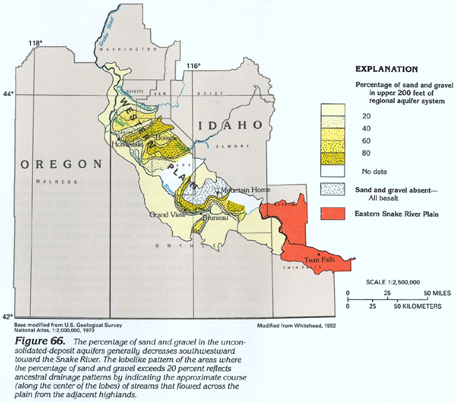
boundary of the western plain. The percentage of the sand and
gravel generally decreases southward as distance from the source
rocks-the highlands on the northern side of the plain-increases
(fig. 66). Older fine-grained deposits
of the unconsolidated-deposit aquifers predominate in the remainder
of the western plain and yield only from 1 to 20 gallons per minute
of water to wells. The water in these aquifers is generally under
confined conditions. Discontinuous lenses of sand and gravel in
the otherwise fine-grained deposits yield from 1 to 100 gallons
per minute of water to wells. Permeable zones exist at depths
of 5,500 feet below the land surface, but the most permeable zones
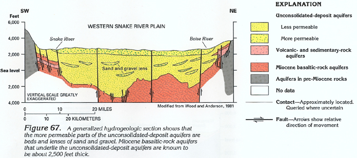
are in the upper 500 feet (fig. 67).
Estimated transmissivity of the upper 500 feet of the unconsolidated-deposit
aquifers is generally less than 20,000 feet squared per day. Along
the margins of the western plain, Miocene basaltic-rock and undifferentiated
volcanic- and sedimentary-rock aquifers are present beneath the
unconsolidated-deposit aquifers and are the principal sources
of geothermal water.
Recharge to the western plain is chiefly from precipitation on the surrounding mountains and from infiltration of excess surface water used for irrigation on the lowlands. Discharge from the aquifer system is by spring flow, seeps, evapotranspiration, and withdrawals from wells.
On the western plain, water for public-supply, domestic and commercial, agricultural (primarily irrigation and livestock watering), and industrial purposes is provided by ground water. To obtain the needed volume, public-supply, irrigation, and industrial wells are usually deeper than domestic and commercial wells and wells used for livestock watering.
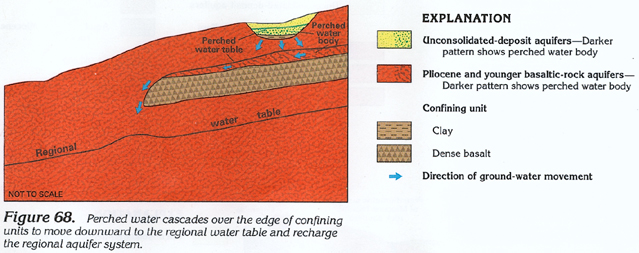
At Mountain Home, a local perched water body that is less than 100 feet thick in unconsolidated deposits supplies water to many domestic wells (fig. 68). A second perched water body of greater areal extent in Pliocene and younger basaltic rocks underlies the unconsolidated deposits. To the south and west of Mountain Home, the confining unit that underlies the second perched water body pinches out, and ground water moves downward through permeable Pliocene and younger basaltic rocks to the regional water table, which is more than 200 feet below the land surface. Total thickness of the Pliocene and younger basaltic-rock aquifer is generally less than 2,000 feet.
A synopsis of some aspects of the ground-water system in the
western plain (fig. 66) is presented
below:
-In Gem, Payette, and Washington Counties, Idaho, the major stream
valleys contain unconsolidated-deposit aquifers that consist of
sand and gravel with varying proportions of clay. Ath the northwestern
end of the western plain in Canyon, gem, Payette, and Washington
Counties, Idaho and Malheur County, Oreg., the unconsolidated-deposit
aquifers are finer grained than in the central part of the plain,
and their permeability is low. Well yields typically range from
1 to 20 gallons per minute but are as much as 3,300 gallons per
minute in places. Miocene basaltic-rock aquifers underlie the
unconsolidated-deposit aquifers and, in places, supply from 1
to 20 gallons per minute of water to wells. Ground water is used
mostly for some agricultural (primarily irrigation) and industrial
purposes.
-Typically, unconsolidated-deposit aquifers in northern Owyhee
County, Idaho, adjacent to the Snake River are fine grained. Therefore,
some communities along the Snake River obtain their water supplies
from wells north of the river in Canyon County, where unconsolidate-deposit
aquifers are more permeable. Hydrogen sulfide and methane are
emitted from some wells because of the organic debris in the fine-grained
unconsolidated deposits. Along the southern side of the Snake
River in Owyhee County, artesian wells drilled at land-surface
altitudes of 2,700 feet or less usually produce free-flowing geothermal
water from faulted volcanic- and sedimentary-rock aquifers. These
aquifers locally are more than 2,000 feet thick, particularly
in the Bruneau-Grand View area, where they are underlain by older
volcanic-rock aquifers (chiefly basalt). These volcanic- and sedimentary-rock
aquifers have low permeability except where they are intersected
by faults. Wells that intersect major faults, most of which trend
northwestward, typically have larger yields than those of wells
in unfaulted areas. Some wells that once flowed have now ceased
because of increased development of the volcanic- and sedimentary-rock
aquifers. In the Bruneau-GrandView area, extensive ground-water
development and water-level declines resulted in the State declaring
this location a Ground-Water Management Area, which is an area
where additional wells can be drilled only with permission after
the State has determined that withdrawals from the proposed well
will not lower the area's water level. Parts of southern Ada and
western Elmore Counties, where most irrigation wells are completed
in Pliocene and younger basaltic-rock aquifers, also have been
declared Ground-Water Management Areas.
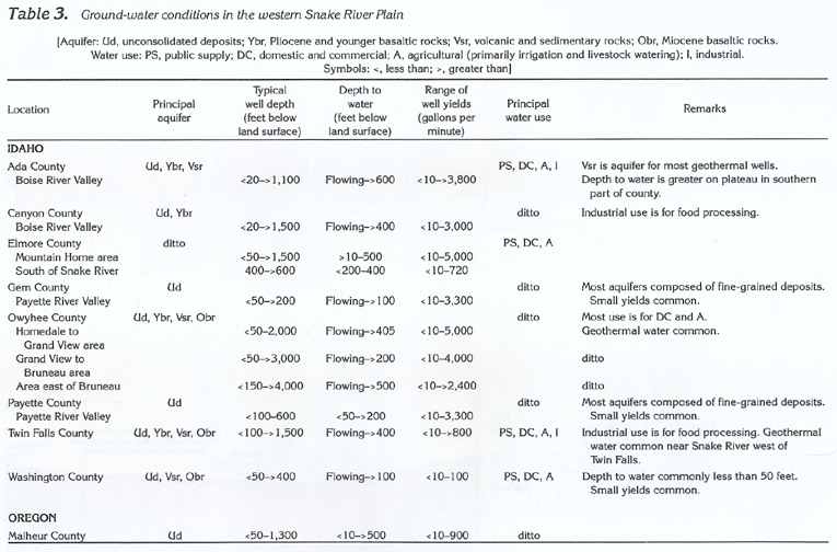
Information pertaining to ground-water conditions in the western plain is summarized by county in table 3.