REGIONAL SUMMARY
INTRODUCTION
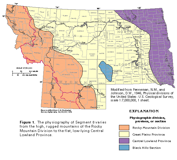
The States of Montana, North Dakota, South Dakota, and Wyoming compose the 392,764-square-mile area of Segment 8, which is in the north-central part of the continental United States. The area varies topographically from the high rugged mountain ranges of the Rocky Mountains in western Montana and Wyoming to the gently undulating surface of the Central Lowland in eastern North Dakota and South Dakota (fig. 1). The Black Hills in southwestern South Dakota and northeastern Wyoming interrupt the uniformity of the intervening Great Plains. Segment 8 spans the Continental Divide, which is the drainage divide that separates streams that generally flow westward from those that generally flow eastward. The area of Segment 8 is drained by the following major rivers or river systems: the Green River drains southward to join the Colorado River, which ultimately discharges to the Gulf of California; the Clark Fork and the Kootenai Rivers drain generally westward by way of the Columbia River to discharge to the Pacific Ocean; the Missouri River system and the North Platte River drain eastward and southeastward to the Mississippi River, which discharges to the Gulf of Mexico; and the Red River of the North and the Souris River drain northward through Lake Winnipeg to ultimately discharge to Hudson Bay in Canada.
These rivers and their tributaries are an important source of water for public-supply, domestic and commercial, agricultural, and industrial uses. Much of the surface water has long been appropriated for agricultural use, primarily irrigation, and for compliance with downstream water pacts. Reservoirs store some of the surface water for flood control, irrigation, power generation, and recreational purposes. Surface water is not always available when and where it is needed, and ground water is the only other source of supply. Ground water is obtained primarily from wells completed in unconsolidated-deposit aquifers that consist mostly of sand and gravel, and from wells completed in semiconsolidated- and consolidated-rock aquifers, chiefly sandstone and limestone. Some wells withdraw water from volcanic rocks, igneous and metamorphic rocks, or fractured fine-grained sedimentary rocks, such as shale; however, wells completed in these types of rocks generally yield only small volumes of water.
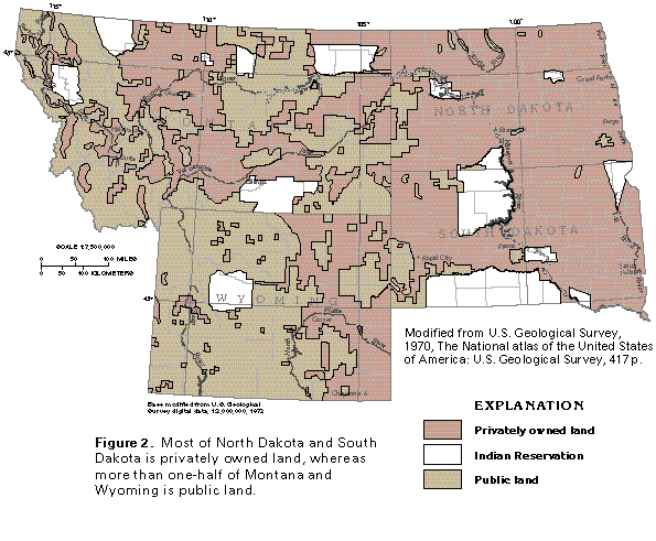
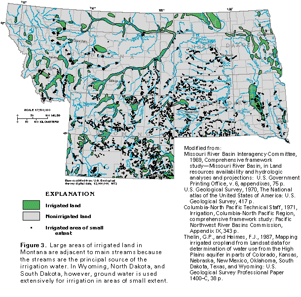
Most wells in the four-State area of Segment 8 are on privately owned land (fig. 2). Agriculture, primarily irrigation, is one of the largest uses of ground water. The irrigation generally is on lowlands close to streams (fig. 3). Lowlands within a few miles of major streams usually are irrigated with surface water that is diverted by gravity flow from the main stream or a reservoir and transported through a canal system. Surface water also is pumped to irrigate land that gravity systems cannot supply. In addition, ground water is pumped from large-capacity wells to supplement surface water during times of drought or during seasons of the year when surface water is in short supply. Ground water is the only source of water for irrigation in much of the segment. The thickness and permeability of aquifers in the area of Segment 8 vary considerably, as do yields of wells completed in the aquifers. Ground-water levels and artesian pressures (hydraulic head) have declined significantly in some places as a result of excessive withdrawals by wells. State governments have taken steps to control the declines by enacting programs that either limit the number of additional wells that can be completed in a particular aquifer or prevent further ground-water development altogether.
The demand for water is directly related to the distribution of people. In 1990, Montana had a population of 799,065; North Dakota, 638,800; South Dakota, 696,004; and Wyoming, 453,588. The more densely populated areas are on lowlands near major streams. Many of the mountain, desert, and upland areas lack major population centers, particularly in Montana and Wyoming, where use of much of the land is controlled by the Federal Government and withdrawal of ground water is restricted.
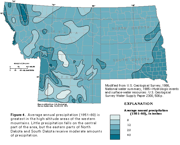
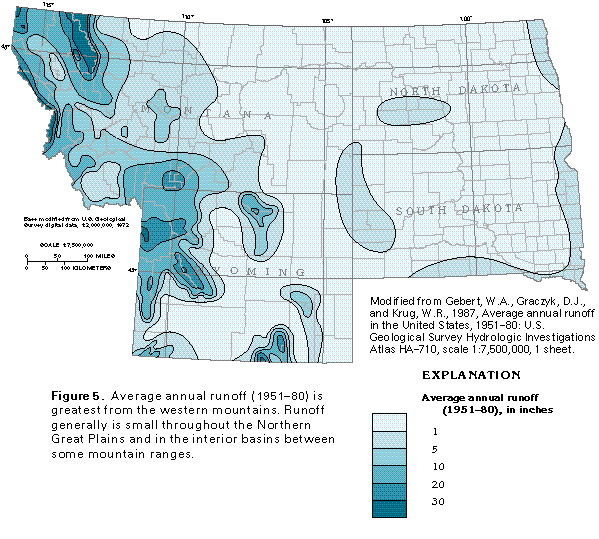
Average annual precipitation (1951-80) in Segment 8 ranges from less than 8 inches in parts of Montana and Wyoming to more than 40 inches in some of the mountainous areas (fig. 4). Most storms move eastward through Segment 8 and are particularly common during the winter months. Moisture that evaporates from the Pacific Ocean is absorbed by eastward-moving air. As the moisture-laden air masses move eastward, they rise and cool as they encounter mountain ranges and lose some of their moisture to condensation. Consequently, the western sides of mountain ranges receive the most precipitation, much of it as snow during the winter months. In contrast, the eastern sides of some of the higher mountain ranges are in rain shadows and receive little precipitation. East of the Continental Divide, precipitation that falls during many summer storms results from northward-moving, moisture-laden air masses from the Gulf of Mexico. These air masses move northward when the polar front recedes; accordingly, a major part of the annual precipitation falls on the plains during the growing season. Average annual precipitation minus the total of average annual runoff plus evapotranspiration (the combination of evaporation and transpiration by plants) is the amount of water potentially available for recharge to the aquifers.
Average annual runoff (1951-80) in the area of Segment 8 varies greatly, and the distribution of runoff (fig. 5) generally parallels that of precipitation. In arid and semiarid areas of the segment, most precipitation replenishes soil moisture, evaporates, or is transpired by vegetation, and only a small part of the precipitation is left to maintain streamflow or recharge aquifers. In wetter areas of the segment, much of the precipitation runs off the land surface directly to perennial streams. Because a smaller percentage of precipitation in wet areas usually is lost to evapotranspiration than in dry areas, more water is, therefore, available to recharge aquifers where more precipitation falls. Precipitation that falls as snow generally does not become runoff until spring thaws begin. Runoff is affected in some areas by reservoirs that have been constructed on major streams to mitigate flooding and to store water for irrigation, electrical power generation, and recreation. Water stored in reservoirs during times when runoff is great is subsequently released during drier periods to maintain downstream flow.
AREAL DISTRIBUTION OF AQUIFERS
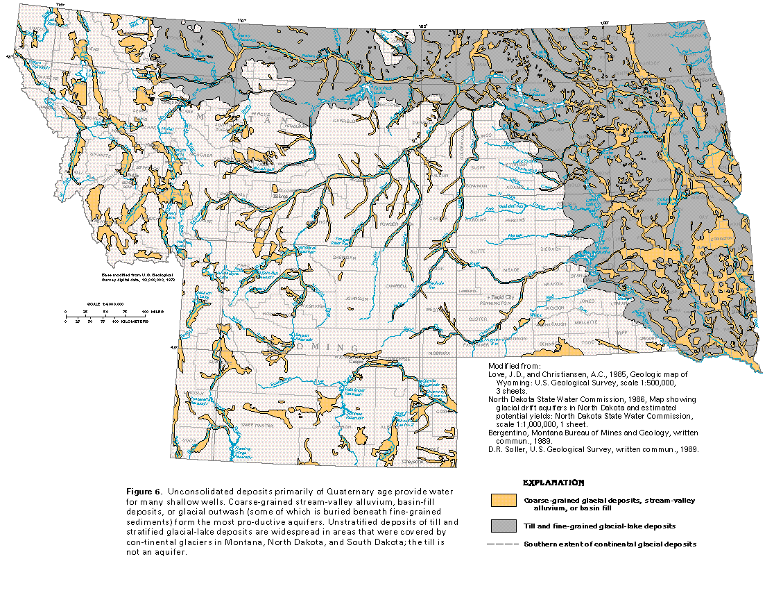
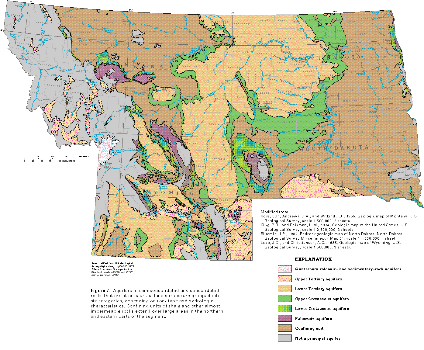
The numerous aquifers in Segment 8 vary greatly in composition. Some of the aquifers consist of unconsolidated sand and gravel; other aquifers consist of semiconsolidated or consolidated sedimentary rocks that are almost flat lying in some places and are folded and faulted in other places; still other aquifers consist of hard, crystalline, igneous and metamorphic rocks that are impermeable except where they are fractured. The different aquifers are grouped into seven categories of principal aquifers in this report, depending on the hydrologic and geologic characteristics of the rocks that compose the aquifers. The extent of the aquifers in unconsolidated deposits primarily of Quaternary age is shown in figure 6. The extent of the remaining six categories of aquifers that are at or near the land surface and that consist primarily of semiconsolidated to consolidated rocks is mapped in figure 7. In the areas where no principal aquifer is mapped, local aquifers may yield small amounts of water to wells.
Aquifers that consist of unconsolidated deposits are in all four States of Segment 8 (fig. 6). The unconsolidated-deposit aquifers consist of sand and gravel of primarily Quaternary age, deposited by glaciers and streams. The glacial deposits are mostly in the northern and eastern parts of the segment and formed during multiple advances of continental ice sheets from the north and northeast during the Pleistocene Epoch. As the huge sheets of ice advanced, rock and soil particles were planed from the land surface and transported in the ice or pushed in front of it. Some of these materials were redistributed by meltwater during ice retreats. Where they consist of stratified sand and gravel, meltwater deposits form productive aquifers. In contrast, clay and silt that were deposited in glacial lakes and poorly sorted, unstratified deposits of clay, silt, sand, gravel, and boulders (called till) have minimal permeability. Many of the aquifers mapped in the eastern parts of North Dakota and South Dakota are buried beneath till or gla-cial-lake deposits. In parts of western Montana and Wyoming, mountain or alpine glaciers locally deposited sand and gravel that constitute the aquifers; most of these deposits are of small extent and are not differentiated in this report from alluvium deposited by streams. Unconsolidated sand and gravel, which were deposited as stream-valley alluvium, are in and adjacent to the channels of most of the larger streams in the segment (fig. 6). Intermontane basins in western Montana and Wyoming have been partially filled by clay, silt, sand, and gravel deposited as coalescing alluvial fans by streams that enter the basins from the surrounding mountains. These alluvial deposits are collectively called basin fill and form productive aquifers where they consist primarily of sand and gravel. In many of the inter-montane basins, particularly in Montana, the basin-fill deposits mapped in figure 6 are hydraulically connected to underlying upper Tertiary aquifers (compare figs. 6 and 7). The unconsolidated-deposit aquifers are important sources of water because they generally are located in flat lowlands where most of the rural and urban population of the segment also is located.
Aquifers in semiconsolidated and consolidated rocks have been divided into six categories in the four States of Segment 8, as shown in figure 7. Some of the aquifers in semicon-solidated and consolidated rocks underlie the glacial and alluvial deposits that compose the unconsolidated-rock aquifers, and the two types of aquifers can be in direct hydraulic connection. The consolidated-rock aquifers are differentiated primarily by rock type (that is, whether they mostly consist of igneous, metamorphic, or sedimentary rocks) and secondarily by the age of the rocks.
Aquifers in volcanic and associated sedimentary rocks are in a small area in northwestern Wyoming and southwestern Montana. These aquifers consist of basaltic and rhyolitic flows, beds of volcanic ash and tuff, and beds of semiconsolidated to consolidated sedimentary rocks that contain volcanic material. The complexly interbedded rocks and deposits that compose these aquifers are of Quaternary age.
Upper Tertiary aquifers are important sources of water in western Montana, southern South Dakota, and southeastern Wyoming; they also supply water locally in central and western Wyoming. These aquifers consist mostly of unconsolidated to semiconsolidated deposits of sand and gravel, commonly interbedded with silt and clay. In Montana, the aquifers locally contain thin beds of volcanic ash and basalt. Most of the rocks that compose the upper Tertiary aquifers are of Pliocene or Miocene age. The upper Tertiary aquifers in Montana and in western and central Wyoming mostly are ancient alluvial deposits that occupy structural basins which are surrounded by mountains. The alluvium was derived from the mountains and transported into the valleys by streams. Upper Tertiary aquifers in southern South Dakota and southeastern Wyoming likewise consist mostly of ancient alluvium deposited by streams, but the alluvium is in the form of wide sheets because the streams that transported it anastomosed across a wide, gentle plain. Lower Tertiary aquifers extend throughout large areas in all four States of Segment 8 (fig. 7) and consist of semicon-solidated to consolidated sedimentary rocks of Oligocene through Paleocene age. Sandstone composes most of the water-yielding beds of these aquifers, but locally, coal beds that are exposed at the land surface have been ignited naturally and the burned coal has formed highly permeable clinker beds that compose high-yielding local aquifers. The sandstone and coal are interbedded with fine-grained rocks, such as shale and siltstone, and locally contain beds of limestone. The fine-grained rocks mostly form confining units but can yield small volumes of water where they are fractured or deeply weathered.
Upper Cretaceous aquifers mostly are deeply buried but are exposed locally at the land surface as a narrow to wide band that borders the lower Tertiary aquifers. The upper Cretaceous aquifers consist of consolidated sandstone and are underlain by a thick sequence of shale that forms a confining unit which separates them from aquifers in older rocks. Locally, where the shale is fractured or deeply weathered, it can yield sufficient water for domestic supplies, but is not considered to be an aquifer in this report.
Lower Cretaceous aquifers consist of consolidated sandstone and are either exposed at the land surface or buried only to shallow depths in three general areas (fig. 7). One area is a broad, irregular band that extends northwestward from central Wyoming through west-central Montana almost to the Canadian border. The second area in northeastern Wyoming and southwestern South Dakota is oval and surrounds older rocks on the flanks of the Black Hills Uplift. The third area is a narrow, discontinuous band parallel to the eastern State line of North and South Dakota where the lower Cretaceous aquifers subcrop beneath glacial deposits. Locally, where sandstones of Jurassic age yield water, they are included as part of the lower Cretaceous aquifers in this report.
Paleozoic aquifers are exposed at the land surface in small, irregular, discontinuous areas in Montana, South Dakota, and Wyoming and subcrop beneath glacial deposits in northeastern North Dakota. These aquifers generally crop out on the flanks of uplifts or where they have been folded upward into anticlines and were subsequently exposed by erosion. Paleozoic aquifers consist of sandstone, dolomite, and limestone; the limestone formations are the most productive aquifers. The Madison Limestone and equivalent rocks of Mississippian age constitute a high-yielding aquifer in upper Paleozoic rocks. Shale, evaporite beds, and salt of Devonian and Silurian age form an effective confining unit that separates the Mississippian aquifers from lower Paleozoic sandstone and limestone aquifers in formations of Ordovician and Cambrian age. Upper and lower Paleozoic aquifers are not differentiated in figure 7 because of the scale of the map.
Rocks throughout large areas of western Montana and northwestern Wyoming generally yield little water to wells. The extremely variable lithology of these rocks includes volcanic rocks, several kinds of igneous and metamorphic rocks, and consolidated sedimentary rocks, some of which are as old as Precambrian. The permeability of these rocks varies greatly because their composition and degree of fracturing varies widely. These rocks are mostly in sparsely populated mountainous areas and the small amounts of water they yield is used primarily for domestic supplies and stock watering. Thus, they are not considered to be major aquifers in this report, even though they may be important local sources of supply. Likewise, local aquifers in Cretaceous and Paleozoic rocks of the thrust belt of westernmost Wyoming are not differentiated because of the scale of the map and are not considered to be major aquifers.
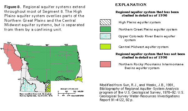
Some of the aquifers in Segment 8 have been grouped together and studied as regional aquifers or regional aquifer systems. An aquifer system is a grouping of two or more aquifers that commonly consist of the same kind of rock, and can be of two types. The first type consists of vertically stacked aquifers that are hydraulically connected; that is, the ground-water flow systems in the aquifers function in a similar manner, and a change in conditions in one of the aquifers affects the other aquifer(s). The second type is a set of aquifers that are not physically connected, but share many common hydrologic and geologic characteristics and thus can best be described and studied together. Both types of aquifer systems are in Segment 8, and their extent is shown in figure 8. Quaternary unconsolidated-deposit aquifers and upper Tertiary aquifers partly fill intermontane basins in western Montana and, although not hydraulically connected, the basins share common geologic and hydrologic characteristics. These basin-fill aquifers collectively compose the Northern Rocky Mountains Intermontane Basins aquifer system. Upper and lower Tertiary aquifers are in direct hydraulic connection in eastern Wyoming and southern South Dakota where they form part of the High Plains aquifer system, which is only in a small part of Segment 8. In southwestern Wyoming, upper and lower Tertiary aquifers, upper and lower Cretaceous aquifers, and Paleozoic aquifers are part of the Upper Colorado River Basin aquifer system. Although the Northern Great Plains aquifer system (fig. 9) contains many of the same aquifers as the Upper Colorado River Basin aquifer system, the two aquifer systems are not hydraulically connected. Deeply buried lower Cretaceous aquifers in small areas in southeastern South Dakota and Wyoming are part of the Central Midwest aquifer system, which is continuous with part of the Northern Great Plains aquifer system to the north. Except for the basin-fill aquifers of the Northern Rocky Mountains Intermontane Basins aquifer system, the regional aquifers and aquifer systems listed above consist of layered rocks that compose stacked aquifers.
GEOLOGY
The geologic and hydrogeologic nomenclature used in this report differs from State to State because of independent geologic interpretations and varied distribution and lithology of rock units. A fairly consistent set of nomenclature, however, can be derived from the most commonly used rock names. Therefore, the nomenclature used in this report is basically a synthesis of that of the U.S. Geological Survey, the Montana Bureau of Mines and Geology, the North Dakota Geological Survey, the South Dakota Geological Survey, and the Geological Survey of Wyoming. Individual sources for nomenclature are listed with each correlation chart prepared for this report.
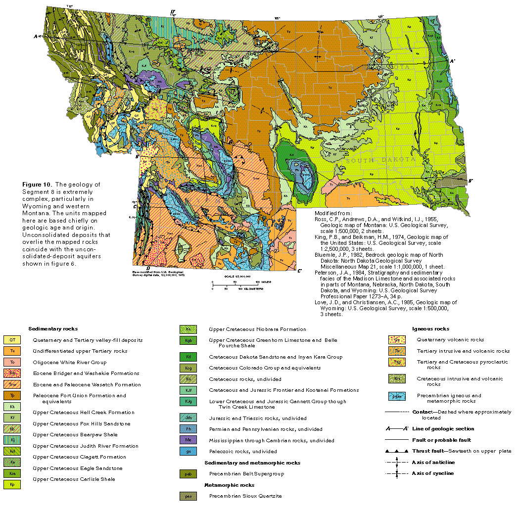
Unconsolidated to consolidated rocks in Montana, North Dakota, South Dakota, and Wyoming range in age from Precambrian to Quaternary (fig. 10). Rocks that are of different ages or compositions from these mapped in the figure might be present locally, especially in mountainous areas that have complex geologic structures, but cannot be shown because of the map scale. Unconsolidated deposits of possibly Pliocene to Holocene age are present throughout large parts of Segment 8 and coincide with the unconsolidated-deposit aquifers mapped in figure 6; accordingly, these deposits are not shown in figure 10. Because rock type largely determines the water-yielding characteristics of the aquifers, the principal aquifer map shown in figure 7 resembles a simplified version of the geologic map shown in figure 10.
Precambrian rocks are exposed mostly in western Montana and in Wyoming, but smaller areas of these rocks are in central Montana, eastern and western South Dakota, and eastern North Dakota (fig. 10). Sedimentary rocks of Precambrian age (the Belt Supergroup) crop out over a wide area in western Montana. In Wyoming and southwestern Montana, Precambrian rocks mostly are plutonic igneous rocks but also include several types of metamorphic rocks. The Precambrian rocks exposed in central Montana and western South Dakota primar-ily are metamorphic rocks. Granitic Precambrian rocks subcrop beneath glacial deposits in easternmost North Dakota, and the Sioux quartzite of Precambrian age directly underlies glacial deposits over a wide area in southeastern South Dakota.
Paleozoic sedimentary rocks, which underlie most of Segment 8, are exposed at the land surface mostly in mountainous areas where they flank uplifts or anticlines, or have been displaced upward along faults. The Paleozoic sedimentary rocks consist mostly of shale, siltstone, sandstone, and carbonate rocks, as well as some salt and evaporite beds, and are deeply buried where they are downwarped in large structural basins.
Mesozoic (chiefly Cretaceous) sedimentary rocks are exposed over wide areas in Montana and Wyoming, and subcrop beneath glacial deposits in large parts of eastern North Dakota and South Dakota. These rocks consist mostly of shale, siltstone, and sandstone but contain some beds of conglomerate, anhydrite, chalk, carbonate rocks, and bentonite (clay that formed from the chemical decomposition of volcanic ash). Like the Paleozoic sedimentary rocks that underlie them, the Mesozoic sedimentary rocks are downwarped in large structural basins in parts of the segment.
Paleocene and Eocene sedimentary rocks are exposed at the land surface chiefly in a wide, irregular band that extends from southwestern Wyoming to northwestern North Dakota (fig. 10). These rocks consist of sandstone, siltstone, and claystone, with some beds of coal and lignite. Large areas of Tertiary intrusive and volcanic rocks are present in northwestern Wyoming and western Montana.
Oligocene and undifferentiated upper Tertiary sedimentary rocks are in scattered areas in southern South Dakota and central and southeastern Wyoming. These rocks consist mostly of semiconsolidated to unconsolidated deposits of clay and sand, with some gravel.
Tertiary and Quaternary valley-fill deposits that consist of unconsolidated gravel, sand, silt, and clay are in western Montana and Wyoming, and Quaternary silicic volcanic rocks are in small areas in northwestern Wyoming and southwestern Montana. These rocks are mostly rhyolite, tuff, and ash-flow deposits and extend throughout most of Yellowstone National Park.
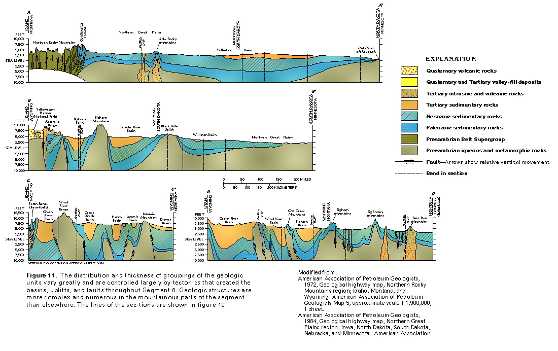
The extent and relations of groupings of the geologic units in the subsurface are shown by the geologic sections in figure 11. Geologic structures, such as faults, anticlines, and synclines, are numerous and complex in the rugged Northern Rocky Mountains of western Montana and in Wyoming, as shown in figure 11. Older rocks have been lifted upward and shifted eastward over younger rocks along thrust faults near the Continental Divide (fig. 11, section A-A') and in the Teton Range (fig. 11, section C-C'). Thick sequences of Paleozoic and younger sedimentary rocks have been downfolded into deep basins, such as the Bighorn and Powder River Basins (fig. 11, section B-B'), and the numerous basins in southern Wyoming shown in figure 11, sections C-C' and D-D'. Some of the basins are bounded by faults, and the combined thickness of rocks is greater than 15,000 feet in many of the basins. Where these sedimentary rocks have been upfolded into anticlines that separate the basins, the rocks have been partly or completely removed by erosion, and older, mostly crystalline rocks are exposed along the axes of the uplifts or anticlines. In Yellowstone National Park (fig. 11, section B-B'), Quaternary volcanic rocks overlie the crystalline rocks.
Eastward from central Montana and eastern Wyoming, the dominant geologic structures are broad, gentle downwarps, some of which are hundreds of miles wide. The Williston Basin, which is shown in figure 11, sections A-A' and B-B', is the largest such structure in Segment 8 and is filled with sedimentary rocks that range in age from Cambrian to Oligocene. The combined thickness of the sedimentary rocks in the Williston Basin is greater than 16,000 feet near the center of the basin, but these rocks thin slightly westward (fig. 11, section A-A') and greatly eastward until they are absent in eastern North Dakota and South Dakota (fig. 11, section B-B') where underlying crystalline rocks are near the land surface and are covered only by glacial deposits. Uplifts, such as the Black Hills Uplift in western South Dakota (fig. 11, section B-B'), are places where the Paleozoic and younger sedimentary rocks have been eroded away and crystalline rocks are exposed.
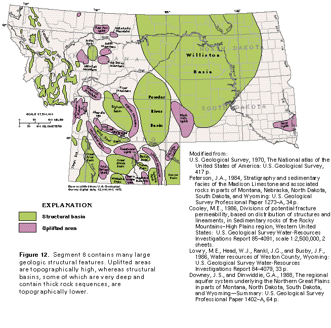
Tectonic forces that acted on the four States produced large areas of subsidence and uplift. Many of the areas of subsidence are large structural basins, but some basins, such as those in the Northern Rocky Mountains, are considerably smaller (fig. 12). Large basins, such as the Bighorn, the Hanna, and the Williston, are more than 16,000 feet deep in their central parts; some of the smaller intermontane basins are less than 3,000 feet deep. The amount of uplift in the segment likewise varies considerably. Some areas of the Middle and the Northern Rocky Mountains have peaks that exceed 12,000 feet in altitude. In contrast, the Judith Mountains and the Black Hills Uplift are much lower and reach altitudes of only about 6,000 and 7,000 feet, respectively.
GROUND-WATER OCCURRENCE AND MOVEMENT
The following primary factors determine the occurrence and movement of water in the aquifers of Segment 8:
· The amount and type of porosity in the deposits and rocks that compose the aquifers
· The degree of interconnection of the pore spaces (permeability)
· Topography of the region
· The availability of recharge
· Geologic structure
Most of the deposits and rocks in the segment, including the shale beds that compose confining units and the dense crystalline rocks that are not principal aquifers, will yield small volumes of water to wells. Only those deposits and rocks that have substantial permeability, however, are considered to be principal aquifers in this report.
The permeability of an aquifer is directly related to the amount and type of porosity of the aquifer material. The most common porosity type in the aquifers of Segment 8 is primary, or intergranular porosity (open spaces between individual grains or rock particles). This is the porosity type in the unconsolidated-deposit aquifers, the unconsolidated to semicon-solidated sand and gravel of the alluvial deposits in the upper Tertiary aquifers, and the consolidated sandstone beds in the lower Tertiary, upper and lower Cretaceous, and Paleozoic aquifers. Beds of fragmented volcanic material, such as ash, tuff, and cinders, also have primary porosity. Vesicles in volcanic rocks and openings formed by cracking of the upper and lower surfaces of basalt flows during cooling also are types of primary porosity. Pore spaces generally are well connected in all rocks with primary porosity in the segment.
Secondary porosity forms after a rock is consolidated or after a flow of volcanic material cools. Secondary porosity in volcanic rocks consists of joints and fractures that formed as shrinkage cracks in the central parts of basalt and rhyolite flows when the flows cooled; basalt and rhyolite are rock types in the Quaternary volcanic- and sedimentary-rock aquifers. However, most of the secondary porosity in the aquifers of Segment 8 consists of joints and fractures that are the result of tectonic activity. All consolidated rocks in the segment are fractured, but the fractures generally are not well connected. Fractures are the principal types of openings in the aquifers in crystalline rocks. Secondary porosity has developed in some of the limestone and dolomite beds in the Paleozoic aquifers as a result of partial dissolution of the carbonate rocks by circulating ground water that commonly is slightly acidic. Solution openings are most common where the carbonate rocks are exposed at land surface or are buried only to shallow depths and large springs issue from some of the solution openings. Some solution openings also are present, however, where the carbonate rocks are deeply buried or where anhydrite or gypsum beds have been partially dissolved.
Geologic structures, such as faults and folds, can affect the movement of ground water on a local to regional scale. Some fault zones, especially those filled with intensely fractured rock, are conduits for the movement and storage of water. Where permeable fault zones extend to great depths, ground water can circulate downward and become heated to greater-than-normal temperatures by geothermal heat sources. Fault zones that are filled with clay or finely ground rock (called fault gouge) are almost impermeable and can form barriers to ground-water flow. Thrust faults, along which older rocks are displaced laterally over younger rocks, can result either in aquifers of different ages being juxtaposed or aquifers being covered with older, less permeable rocks. Aquifer recharge areas coincide with the crests or axes of anticlines where permeable rocks have been folded upward and are exposed at the land surface or with the flanks of anticlines or monoclines where these structures have been eroded. Water generally moves from these recharge areas toward troughs that represent the axes of synclines. The aquifers commonly contain highly mineralized water in the synclines where they have been downwarped to great depths.
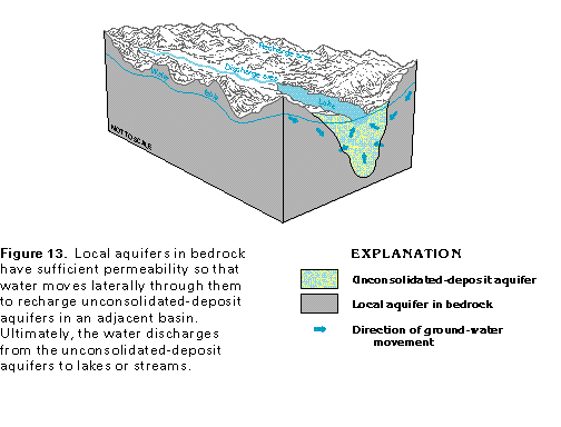
Water in all the aquifers moves in response to gravity from recharge areas down the hydraulic gradient to discharge areas. Much of the recharge is from precipitation that falls directly on the aquifers where they are at or near the land surface in topographically high areas, but some of the recharge is by leakage through the beds of streams that cross the aquifers. The water percolates downward, enters the aquifers, and subsequently moves toward discharge areas at lower altitudes. Some buried aquifers receive recharge by downward leakage from overlying aquifers. This situation is common in areas where unconsolidated-deposit aquifers overlie bedrock aquifers in the central and eastern parts of the four-State segment. Locally, water can move upward from deeply buried aquifers along zones of fractured rock to recharge shallower aquifers. Certain aquifers are recharged in some places by lateral flow from adjacent aquifers. Lateral recharge is particularly important in the basin-fill aquifers of western Montana and Wyoming (fig. 13). Local aquifers in bedrock receive recharge directly from precipitation; some of the water then moves laterally into the unconsolidated-deposit aquifers that partially fill basins in the bedrock. The water moves through the unconsolidated-deposit aquifers and discharges to surface-water bodies, such as lakes or streams, near the basin centers. Water in the local bedrock aquifers and the unconsolidated-deposit aquifers shown in figure 13 is under unconfined, or water-table, conditions.
All the aquifers of Segment 8 discharge mostly by movement of water to lakes and streams, by leakage to shallower aquifers, and to springs. Some water discharges by evapotranspiration (the sum of transpiration by plants and evaporation) and withdrawals from wells.
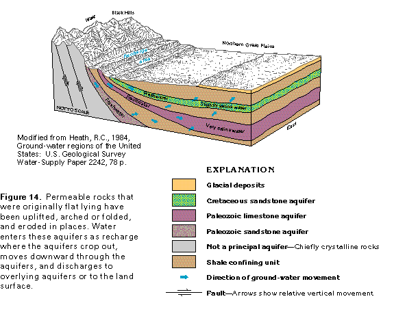
Many of the aquifers in Segment 8 consist of sedimentary rocks, such as sandstone and limestone, that alternate with confining units of fine-grained sediments, such as shale. Tectonic forces uplifted these originally flat-lying sedimentary layers in places and arched them upward over crystalline rocks that are the centers of anticlines or uplifts (fig. 14). Erosion subsequently removed the sedimentary rocks from the central parts of the upfolded rocks and exposed the permeable sediments along the flanks of mountainous areas, such as the Black Hills Uplift of western South Dakota. Precipitation that falls on the flanks of the mountains provides some direct recharge to the sandstone and limestone aquifers; some water leaks downward through the beds of streams that flow across the aquifers; and some water leaks upward or downward through confining units from vertically adjacent aquifers, thus providing additional recharge. The water moves down the dip of the aquifers, discharges as upward leakage through confining units to shallower aquifers (fig. 14), and might eventually reach the surface or be discharged to a deeply entrenched major stream that acts as a regional drain. Circulation is sluggish in the deeply buried parts of the aquifers; accordingly, many aquifers contain slightly saline to very saline water at depth. Except where the aquifers crop out, water in the sandstone and limestone aquifers shown in figure 14 is under confined, or artesian, conditions. The water levels in wells completed in the confined parts of these aquifers accordingly will rise above the tops of the aquifers. If the hydraulic head in one of the aquifers is large enough, then water can rise above the land surface, and a well completed in the aquifer will flow. In places in Segment 8, the hydraulic head in some of the aquifers is as much as 1,000 feet above the land surface.
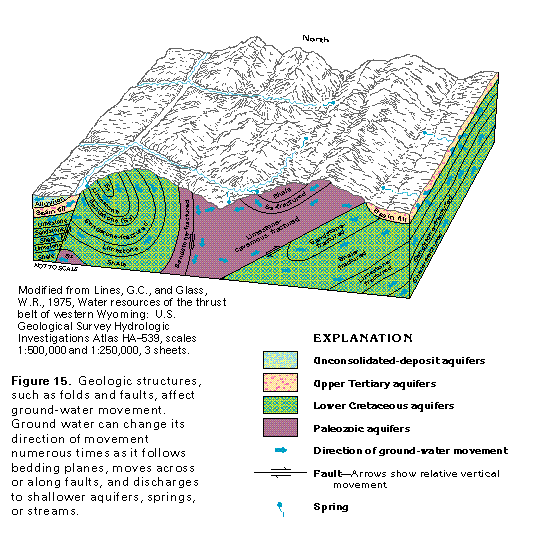
An example of the way in which geologic structures, such as folds and faults, affect the movement of ground water is shown in figure 15. Water generally enters the sandstone and limestone aquifers in topographically high recharge areas, although some water can move through the shale confining units where the shale is fractured. In folded and faulted rocks, the water generally follows a tortuous route from recharge areas to discharge areas-it first moves parallel to the folded bedding planes of the aquifers and then moves along or across fault planes to enter other aquifers on the opposite side of the fault. Some of the water discharges upward to overlying aquifers, and some issues as springflow where folded, permeable beds are exposed at the land surface (fig. 15). Not all faults are conduits for ground-water flow. Fault zones that are filled with clay or that have become sealed with silica or other minerals as a result of fault movement are practically impermeable, whereas those filled with rock fragments can be extremely permeable. Some faults permit water to circulate to great depths where it can become heated by geothermal heat sources. The permeability of the more consolidated, dense, and unweathered rocks generally is more likely to be increased by faulting.
The aquifers in Segment 8 yield variable amounts of water. Unconsolidated deposits and consolidated sedimentary rocks are the most productive aquifers, whereas crystalline rocks generally are the least permeable rocks. Well yields adequate to supply domestic and livestock-watering needs (generally less than 20 gallons per minute) can be obtained from most of the aquifers. The largest yields in the segment are from wells completed in carbonate rocks of the Paleozoic aquifers; some wells completed in these aquifers yield as much as 14,000 gallons per minute.
WATER-LEVEL FLUCTUATIONS
Regardless of whether the water in an aquifer or aquifer system is under unconfined or confined conditions, water levels in wells completed in the aquifer or aquifer system reflect the balance between ground-water recharge and discharge. When recharge exceeds discharge, water levels rise; when discharge exceeds recharge, water levels decline. Recharge and discharge tend to balance under long-term natural conditions; such a balance is called a steady-state condition. Climatic changes, fluctuations of weather, or ground-water development can change the steady-state condition so that water levels either rise or fall. Local ground-water development might affect only a single well or a few nearby wells and might not show a regional effect in an areally extensive aquifer.
Ground-water levels can fluctuate when natural recharge or discharge is affected by human activities. When natural recharge is decreased, ground-water levels decline; when natural recharge is increased or when natural discharge is decreased, ground-water levels rise. Changes in irrigation practices, such as the use of sprinklers to replace furrow and flood irrigation, reduce the volume of water available to recharge aquifers by seepage from irrigated fields. If the source of irrigation water changes from imported surface water to local ground water, then water from an outside source is no longer available for recharge as irrigation return flow, and ground-water levels will decline. Sealing and lining earthen canals or reservoirs can reduce the volume of water lost by seepage during transmission and storage, and, thereby, can reduce recharge to aquifers. Where urban shopping centers, residential subdivisions, and industrial development replace irrigated farmland, recharge is reduced because the paving associated with these types of development reduces the area of soil into which precipitation can infiltrate. Dewatering during mining activities can cause a large decline in water levels. The construction of a reservoir or a rise in the water level of an existing lake or reservoir can cause the water level in nearby aquifers to rise.
Ground water is becoming more and more important as a source of water for public supply, domestic and commercial uses, and industrial and agricultural (primarily irrigation) needs in the four-State area of Segment 8. Generally, increased ground-water withdrawals cause water levels to decline except where increased recharge is possible.
SHORT-TERM FLUCTUATIONS
Under natural conditions, ground-water levels in or near recharge areas throughout most of Segment 8 generally are highest in the spring as a result of recharge from snowmelt and rainfall. Water levels decline rapidly during the summer when evapotranspiration rates are highest and discharge exceeds recharge. Water levels continue to decline at a slower rate through the fall and winter months until recharge resumes in the spring and thereby completes an annual cycle. The magnitude of the seasonal fluctuation usually is least in deeply buried aquifers and in places distant from recharge areas. Seasonal water-level fluctuations in Segment 8 range from a few feet to several tens of feet or more.
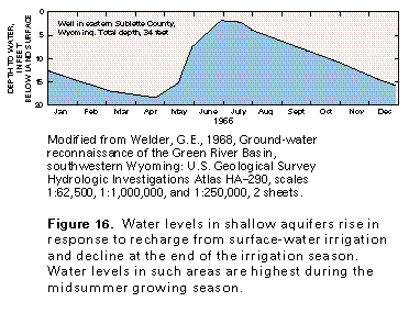
In areas irrigated with surface water, losses through canal linings and by downward seepage from irrigated fields constitute a significant source of recharge to aquifers. Ground-water levels in such areas typically begin to rise during April and May when surface water is first released to canals and fields (fig. 16), reach a maximum in midsummer, start to decline at the end of the irrigation season, and continue to decline to an annual minimum just before the start of the next growing season.
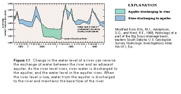
Water-level changes in unconsolidated-deposit aquifers that are in direct hydraulic connection with streams coincide with changes in the water level of the streams. When the water in a stream, such as the Big Sioux River in Brookings County, S. Dak., is at a high level, the river discharges water to the adjacent aquifer (fig. 17). Conversely, when water in the river is lower than the water level in the adjacent aquifer, the aquifer discharges to the river. The movement of water from the aquifer to the river is indicated by springs and seeps along the river channel. Ground-water discharge sustains minimum streamflow (base flow) during periods of less-than-normal precipitation and times when water from the river is diverted upstream.
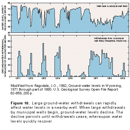
Ground-water levels commonly fluctuate in response to nearby withdrawals. During periods of large withdrawals, water levels in an aquifer decline. If recharge to the aquifer is sufficient, however, then water levels usually recover to the prepumping level when withdrawals cease. For example, large withdrawals from a municipal well field in the High Plains aquifer system at Cheyenne, Wyo., have a rapid effect on the water level in a well completed in the same aquifer less than 1 mile away (fig. 18). Withdrawals usually are largest during the summer months. During periods of normal precipitation, such as 1971 through 1976, large withdrawals cease in late summer or fall. Ground-water levels quickly recover but may show a slight seasonal decline until recharge increases in the spring. Withdrawals were large throughout 1977 and 1978, which was a period of less-than-normal precipitation. Ground-water levels, therefore, were low throughout this 2-year period and had not fully recovered by the end of 1979, even though precipitation had increased and less water was withdrawn from the aquifer. This example shows that human activities can have a great effect on ground-water levels.
LONG-TERM FLUCTUATIONS
Long-term trends in ground-water levels generally are caused by the following factors:
· Long-term cycles of greater-than-normal or less-than-normal precipitation
· Long-term withdrawals of ground water in excess of natural recharge
· Changes in irrigation practices
· Changes caused by other human activities
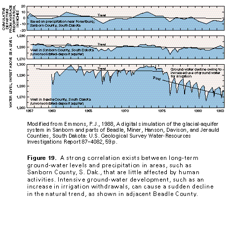
Natural long-term trends of ground-water levels mimic long-term precipitation trends, as shown in figure 19. For example, cumulative departures from average annual precipitation in Sanborn County, S. Dak., show a slight decline from 1957 through 1983. Water levels in a well completed in an unconsolidated-deposit aquifer in Sanborn County show a similar slight decline for the same period, which indicates little effect from human activities. By contrast, in adjacent Beadle County, increased withdrawals of ground water for irrigation, which began in 1975, caused a sudden change in the trend of ground-water levels in the same aquifer. Water levels declined much more rapidly after irrigation began.
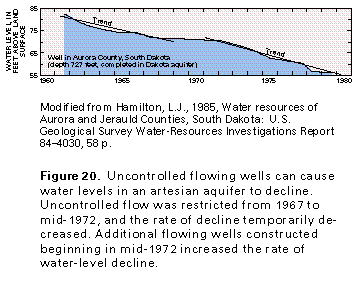
Water levels have declined steadily in South Dakota in some parts of the confined Dakota aquifer, which is considered to be part of the lower Cretaceous aquifers in this report (fig. 20). The decline is largely the result of uncontrolled flow from wells completed in the aquifer. Water levels in an observation well in Aurora County show a trend of steady decline from 1961 to 1966, but the rate of decline decreased from 1967 to mid-1972 when many owners of flowing wells restricted flow from the wells. From mid-1972 to 1979, new flowing wells were constructed within a 10-mile radius of the observation well. As a result, the rate of water-level decline increased to slightly more than the pre-1967 rate.
GROUND-WATER QUALITY
The concentration of dissolved solids in ground water provides a basis for categorizing the general chemical quality of the water. Dissolved solids in ground water primarily result from chemical interaction between the water and the rocks or the unconsolidated deposits through which the water moves. Rocks or deposits that consist of readily dissolved minerals will usually contain water that has large dissolved-solids concentrations. The rate of movement of water through an aquifer also affects dissolved-solids concentrations; the longer the water is in contact with the minerals that compose an aquifer, the more mineralized the water becomes. Thus, larger concentrations of dissolved solids commonly are in water at or near the ends of long ground-water flow paths. Aquifers that are buried to great depths commonly contain saline water or brine in their deeper parts, and mixing of fresh ground water with this saline water can result in a large increase in the dissolved-solids concentration of the freshwater. Contamination that is the result of human activities can increase the concentration of dissolved solids in ground water; such contamination usually is local but can render the water unfit for human consumption or for many other uses.
The terms used in this report to describe water with different concentrations of dissolved solids are as follows:
Term |
Dissolved-solids concentration, in milligrams per liter |
| Freshwater | Less than 1,000 |
| Slightly saline water | 1,000 to 3,000 |
| Moderately saline water | 3,000 to 10,000 |
| Very saline water | 10,000 to 35,000 |
| Brine | Greater than 35,000 |
Dissolved-solids concentrations in ground water generally are small in aquifer recharge areas and increase as the water moves downward into the deeper parts of the aquifers. Where the aquifers are deeply buried or where ground water is discharged at the end of long flow paths, dissolved-solids concentrations commonly exceed 3,000 milligrams per liter. In some places, saline water or brine in deep aquifers leaks upward through confining units and contaminates fresher water in shallower aquifers or in surface-water bodies. For example, in easternmost North Dakota, water with more than 3,000 milligrams per liter dissolved solids occurs locally in the shallow, unconsolidated-deposit aquifer and in the Red River of the North and its tributaries. In this area, very saline water discharges upward from bedrock aquifers and moves first into the shallow aquifer, where it mixes with freshwater, and subsequently into the streams.
Throughout large parts of Segment 8, dissolved-solids concentrations in ground water exceed the secondary maximum contaminant level of 500 milligrams per liter recommended for drinking water by the U.S. Environmental Protection Agency. In some places, water with dissolved-solids concentrations of 2,000 milligrams per liter or more is used for human and livestock consumption because no fresher water is available.
Ground-water contamination that results from human activities can take place more rapidly than natural contamination. Such contamination is categorized as being from either a point source or a nonpoint source. A point source is a specific local site, such as an underground storage tank that contains wastes, petroleum, or chemicals; a landfill; a storage pond, pit, or lagoon; a spill of hazardous chemicals or petroleum products; or a disposal or injection well that receives municipal or industrial wastes. Nonpoint contamination sources are large scale and can extend over hundreds of acres. Examples of nonpoint sources are agricultural activities, such as the application of fertilizer or pesticides to fields; urban areas with concentrations of septic tanks and cesspools; encroachment of saltwater or highly mineralized geothermal water; animal feedlots; mining operations; oilfields and associated tank farms; salt from highway deicing; and concentration of salts from mineralized irrigation water in places where evaporation rates are high and the soil is poorly drained.
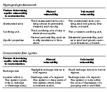
Aquifers that are shallow, unconfined, and receive recharge at rapid rates are most susceptible to contamination from human activities because water quickly infiltrates from the land surface to such aquifers; thus, contaminants have little potential to be absorbed by soil minerals or dispersed, and might be undiluted or only slightly diluted when they enter the aquifer. Aquifers that consist of limestone, dolomite, or basalt are particularly susceptible to contamination because they commonly contain large openings (solution cavities, joints, or cooling fractures) that allow water to enter the aquifer almost instantaneously. Confined aquifers are less susceptible to contamination than unconfined aquifers because the confined aquifers usually are deeply buried and are overlain by confining units that have minimal permeability. Infiltration of contaminants into confined aquifers, therefore, is slow and the contaminant is more likely to be absorbed by the confining unit. The following table lists some of the features that determine the susceptibility of an aquifer to contamination and indicates the relative vulnerability of the aquifer, based on the characteristics of each feature:
FRESH GROUND-WATER WITHDRAWALS
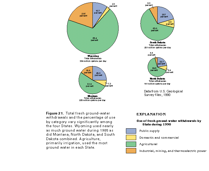
Total withdrawals of fresh ground water in the four-State area during 1990 were 981 million gallons per day. Almost 40 percent of this amount, or 384 million gallons per day, was withdrawn in Wyoming (fig. 21). Withdrawals in Montana, North Dakota, and South Dakota were about 205 million, 141 million, and 251 million gallons per day, respectively. The percentage of water withdrawn for different uses varies from State to State. In each of the States, however, agricultural use, primarily irrigation, is the largest use category (fig. 21). In Montana, North Dakota, and South Dakota, public supply is the second largest use category; in Wyoming, however, the second-largest category is industrial, mining, and thermoelectric power uses, with most of the water being used for mining, including oil and gas production. During 1990, 19 million gallons per day of saline water also was withdrawn in Wyoming for mining use, although figure 21 shows only freshwater withdrawals.
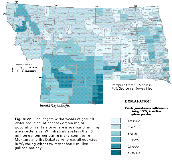
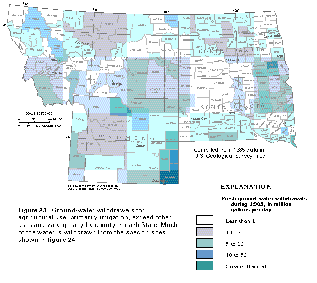
Total fresh ground-water withdrawals, by county, vary considerably, as shown in figure 22. Because the largest withdrawals are for agricultural purposes (primarily irrigation), followed by withdrawals for public supply and mining, the withdrawals are not evenly distributed throughout most counties. The distribution of withdrawals for agricultural use, by county, are shown in figure 23. Areas of extensive irrigation in northern and southeastern Wyoming, central and southeastern North Dakota, eastern and south-central South Dakota, and some of the intermontane basins of western Montana and Wyoming are prominent in figure 23.
Much of the water is withdrawn from the specific sites shown in figure 24. Irrigation projects in all four States account for most of the withdrawals, but sites where water is withdrawn for public supply and industrial (primarily mining) uses also are prominent. The tables at right list the major withdrawal sites, by location; identify the aquifer or aquifers from which the water is withdrawn; and indicate the use of the water at each location.