REGIONAL AQUIFER SYSTEMS
REGIONAL AQUIFER SYSTEMS
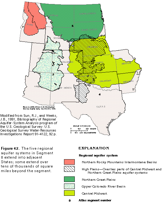
Most of the aquifers in Montana, North Dakota, South Dakota, and Wyoming are parts of five large regional aquifer systems. An aquifer system consists of two or more aquifers that function similarly. The aquifers can be hydraulically connected so that a change in hydrologic conditions in one of the aquifers will affect the other aquifers or separated but with common geologic and hydrologic characteristics. Much of the freshwater that is withdrawn in Segment 8 is obtained from the regional aquifer systems, some of which extend far beyond the boundaries of the segment.
As of 1996, four of the regional aquifer systems shown in figure 42 have been studied as part of the Regional Aquifer-System Analysis (RASA) Program of the U.S. Geological Survey. A study of the Northern Rocky Mountains Intermontane Basins aquifer system is underway, but not completed as of 1996. The objectives of each RASA study are to describe the ground-water flow system as it existed before development (under natural conditions) and as it exists at present, to describe and explain the changes in the flow system, to combine the findings of previous studies of the aquifer system, and to evaluate the probable effects of future development of the aquifer system. A digital computer simulation of the aquifer system usually is used to meet the last objective listed. The regional aquifer systems that have been studied in Segment 8 are the High Plains, the Northern Great Plains, the Upper Colorado River Basin, and the Central Midwest. The High Plains was referred to only as an aquifer in the RASA study, but will be referred to as an aquifer system herein. All the aquifer systems extend beyond the boundaries of the segment, some of them for great distances. However, the segment contains more than one-half of the Northern Rocky Mountains Intermontane Basins aquifer system and all but a small portion of the part of the Northern Great Plains aquifer system that is within the United States. Three of the aquifer systems, the High Plains, the Upper Colorado River Basin, and the Central Midwest, extend for tens of thousands of square miles beyond Segment 8 (fig. 42) and are discussed in greater detail in other chapters of this Atlas.
Regional aquifer systems of two types, and examples of both, are in Segment 8. One type is an extensive sequence of aquifers and confining units, which usually, but not always, is arranged as a stack of layers, that might be discontinuous locally but function regionally as a single aquifer system. The High Plains, the Northern Great Plains, the Upper Colorado River Basin, and the Central Midwest aquifer systems in Segment 8 are examples of this type. The second type is a set of virtually independent aquifers that might be partly or completely separated from each other by rocks with low permeability but that share common hydrologic characteristics. The same hydrologic factors and principles control the occurrence, movement, and quality of the water in these aquifers, and, therefore, the study of a few representative aquifers provides a basic understanding of them all. The Northern Rocky Mountains Intermontane Basin aquifer system in Segment 8 is an example of this type.
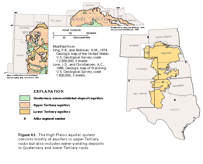
The High Plains aquifer system, which is called the High Plains aquifer in many reports, covers an area of about 4,800 square miles in South Dakota and about 8,000 square miles in Wyoming (fig. 43). Although the aquifer system is an important source of water in both States, most water is withdrawn from the system outside Segment 8. During 1980, for example, less than 1 percent of the water pumped from the aquifer system for agricultural irrigation was withdrawn in South Dakota and Wyoming. At present (1996), withdrawals in the two States are slightly greater than those in 1980.
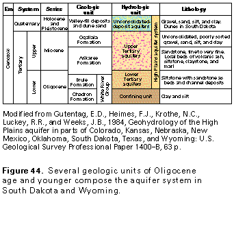
Most wells completed in the High Plains aquifer system obtain water from upper Tertiary aquifers that consist of the Ogallala Formation of Miocene age and the Arikaree Formation of Miocene and Oligocene age (fig. 44). The unconsolidated sand and gravel beds of the Ogallala Formation yield water much more readily than the sandstone beds of the Arikaree Formation. The consolidated siltstone and sandstone of the Brule Formation of Oligocene age yield highly variable volumes of water; yields are greatest where the beds have been fractured. Valley-fill and dune deposits of Quaternary age are hydraulically connected to the aquifers in Tertiary rocks and are included in the High Plains aquifer system. These permeable deposits are important recharge areas because they readily absorb and temporarily store precipitation before it percolates downward to recharge underlying permeable beds. Except for the dune sands, which were deposited by wind, all the rocks and deposits that compose the High Plains aquifer system were deposited by streams. The streams probably were braided streams that flowed eastward from the Rocky Mountains and constantly shifted their channels across a broad plain that sloped gently to the east.
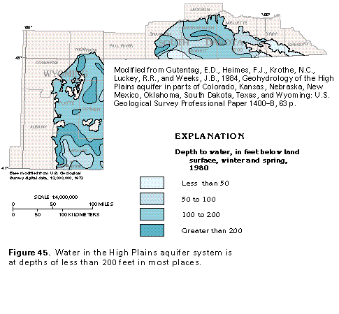
Depth to water in the High Plains aquifer system ranges from less than 50 to almost 300 feet (fig. 45). Depth to water in the aquifer system in late winter and early spring 1980 generally was less than 200 feet below land surface in South Dakota and Wyoming. Locally in South Dakota the depth to water was less than 50 feet below land surface. The map in figure 45 represents the shallowest depth to water during 1980 because the water levels used to construct the map were measured during the time of year when precipitation is greatest and evaporation and the use of water by plants is least.
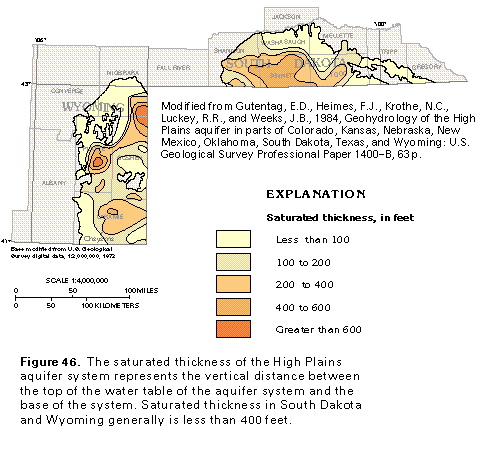
Recharge enters the aquifer system as direct infiltration of precipitation and as seepage through the beds of streams or from irrigated land. Recharge is rapid where the surficial material consists of dune sand, stream-valley deposits of sand and gravel, or highly weathered sediments and is slower where sandstone or local beds of fine-grained sediments are at the land surface. Discharge is by the movement of water to streams, evapotranspiration, and withdrawal from wells. The thickness of saturated aquifer material (fig. 46) represents the vertical distance between the water table and the base of the aquifer system and reflects the balance between recharge and discharge at a given time. The saturated-thickness map shown in figure 46 is for the late winter and early spring months of 1980 and probably represents the maximum saturated thickness for that year. Saturated thickness ranged from zero at the boundary of the aquifer system to more than 600 feet in local areas in Wyoming, and more than 400 feet in places in South Dakota. In most places, saturated aquifer material was less than 400 feet thick. Although the volume of water in the saturated aquifer material in South Dakota and Wyoming in 1980 was more than 1.6 billion acre-feet (1 acre-foot is the volume of water that will cover 1 acre of land surface to a depth of 1 foot), this does not mean that all the water can be withdrawn by wells. The hydraulic characteristics of the High Plains aquifer system are such that only about 130 million acre-feet, or about 8 percent of the water in the saturated aquifer material, can be withdrawn. Even though the volume of 1.6 billion acre-feet of saturated material in South Dakota and Wyoming seems large, this represents only about 7 percent of the saturated volume of material in the aquifer system. The remaining 93 percent is in the vast part of the system that extends southward as far as Texas.
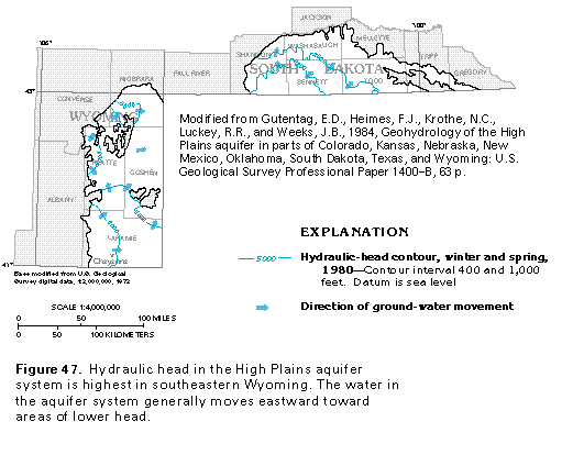
Water in the High Plains aquifer system generally moves from west to east but locally moves from south to north (fig. 47). Much of the water is under unconfined conditions, but clay beds and lenses of other fine-grained materials locally create confined conditions. The hydraulic head in the aquifer system is greatest near Cheyenne, Wyo. (fig. 47), and least in south-central South Dakota. The water moves eastward at an estimated average velocity of about 1 foot per day.
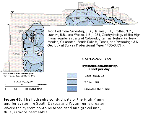
The hydraulic conductivity of the High Plains aquifer system (fig. 48) varies little in South Dakota and Wyoming. Hydraulic conductivity is a measure of the rate at which water will pass through an aquifer and is directly related to the permeability of the aquifer. The greater the hydraulic conductivity value, the easier water is able to move through the aquifer (or, the higher the permeability of the aquifer). Well yields are directly related to hydraulic conductivity; the greater the hydraulic conductivity, the larger the yields of wells completed in a given thickness of the aquifer. The lithology of the aquifer is the property that most directly affects hydraulic conductivity. Coarse-grained, well-sorted sand, for example, has a high hydraulic conductivity, whereas sediments with much admixed or interbedded clay do not. The different geologic formations that compose the High Plains aquifer system vary somewhat in lithology and, therefore, their hydraulic conductivity and the yields of wells completed in them also vary. The Brule Formation usually is the least productive part of the aquifer system, and high-capacity wells completed in the Brule typically yield less than 300 gallons per minute. However, wells completed in the Brule where it is fractured, as in southeasternmost Wyoming, have been reported to yield as much as 1,500 gallons per minute. The Arikaree Formation yields slightly more water, with average high-capacity well yields of about 350 gallons per minute and maximum yields of about 600 gallons per minute reported. Yields of high- capacity wells completed in the Ogallala Formation commonly are 1,000 gallons per minute. Well yields that range from 250 to 750 gallons per minute can be expected from the High Plains aquifer system throughout about 80 percent of its extent in South Dakota and Wyoming.
The quality of the water in the High Plains aquifer system in South Dakota and Wyoming is suitable for most uses practically everywhere. Locally, dissolved-solids concentrations in the water exceed the 500-milligram-per-liter secondary maximum contaminant level recommended for drinking water by the U.S. Environmental Protection Agency. In much of South Dakota and in small areas south of the North Platte River in Wyoming, the water contains sodium concentrations that range from 50 to 100 milligrams per liter. Continued application of irrigation water with large concentrations of sodium can adversely affect some plants and can decrease soil permeability, but neither effect has been observed in Segment 8 at present (1996). In some areas in South Dakota, selenium concentrations in the water exceed the drinking-water standard of 10 micrograms per liter. Selenium concentrations are greatest in areas where the High Plains aquifer system directly overlies the Pierre Shale; the selenium is leached from the shale by ground water.
NORTHERN GREAT PLAINS AQUIFER SYSTEM
The Northern Great Plains aquifer system underlies most of North Dakota and South Dakota, about one-half of Montana, and about one-third of Wyoming (fig. 49). The aquifer system is mostly within the Williston Basin, which is a large structural trough that extends from Montana into North Dakota, South Dakota, and Canada; the Powder River Basin in northeastern Wyoming; and areas of structural uplifts that flank these basins. The Canadian part of the aquifer system is not described in this report. The United States part of the aquifer system extends over about 300,000 square miles, all of which is within Segment 8 except for a small area in northwestern Nebraska.
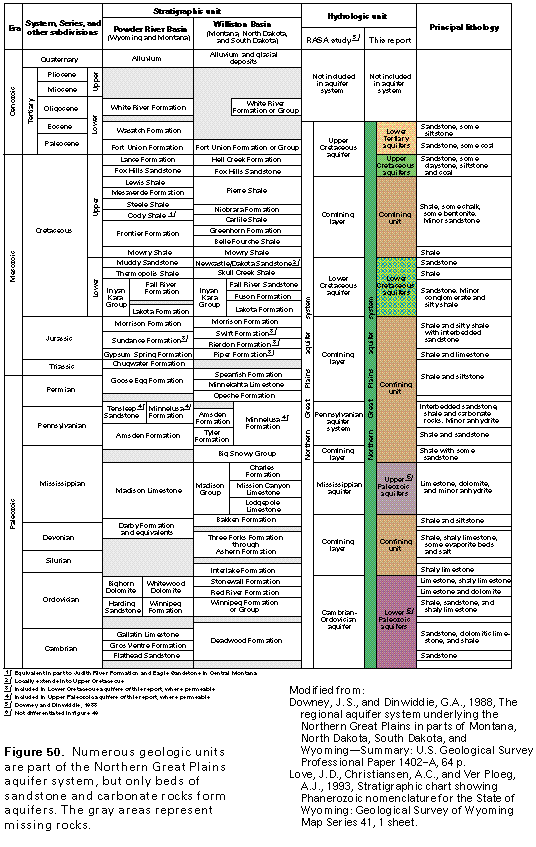
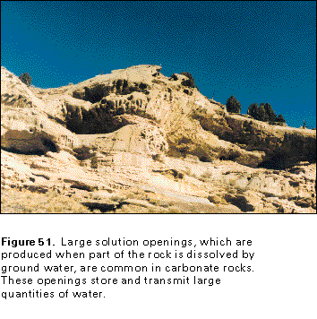
The major aquifers of the Northern Great Plains aquifer system are sandstones of Tertiary and Cretaceous age and carbonate rocks of Paleozoic age (fig. 50). These aquifers, along with regional confining units that separate some of them, form one of the largest confined aquifer systems in the United States. In some places, local confining units separate the major aquifers into smaller, individual aquifers, but each major aquifer can be treated regionally as a single, large aquifer. Unconsolidated glacial and alluvial deposits of Quaternary age, some of which are highly permeable, locally overlie the aquifer system, but are not included in it because the shallow ground-water flow system in these deposits is very different from the deep, confined flow in the Northern Great Plains aquifer system. Crystalline rocks that underlie the aquifer system yield little water and are considered to be the base of the system. Open spaces in the sandstone aquifers are mostly pores between individual sand grains, but local larger openings include bedding planes, fractures, or faults. By contrast, large open spaces are common in carbonate rocks (fig. 51) where part of the rock has been dissolved by circulating ground water. Water moves freely through the dissolution openings, and carbonate rocks accordingly form high-yielding aquifers in many places.
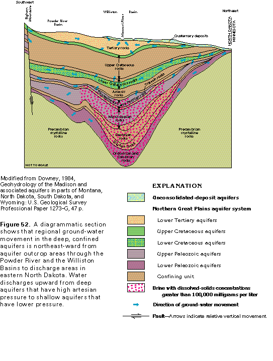
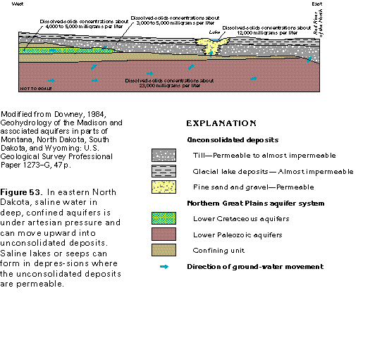
Regional movement of water in the Northern Great Plains aquifer system is from recharge areas at high altitudes, down the dip of the aquifers and then upward to discharge into shallower aquifers or to the land surface. Much of the water moves into and through the Powder River and the Williston Basins (fig. 52). The regional direction of flow in the deep, confined aquifers follows long flow paths and is from southwest to northeast. Most of the recharge to the aquifer system is either from precipitation that falls on outcrop areas where the aquifers have been folded or faulted upward and subsequently exposed by erosion or from snowmelt that runs into streams that cross aquifer outcrops and seeps downward through the stream beds into the aquifers. Some local recharge is by seepage of excess irrigation water. Much of the discharge from the aquifer system is by upward leakage of water into shallower aquifers where the hydraulic head in the shallower aquifer is less than that of a deeper aquifer. Some water discharges to lakes and streams near the North Dakota/Minnesota State line. In eastern North Dakota, highly mineralized water discharges from the lower Paleozoic aquifers by upward leakage through confining units into overlying unconsolidated deposits that are mostly till and glacial-lake sediments (fig. 53). Some of this saline water moves through permeable parts of the unconsolidated deposits into lakes, streams, and wetlands that are in depressions. Where confining units are absent, the saline water can move directly from the lower Paleozoic aquifers into the unconsolidated deposits and then into streams as shown near the right side of figure 53. Some discharge from the Northern Great Plains aquifer system also is by withdrawals from wells or from flowing wells in places where artesian pressure is sufficient to allow water in confined aquifers to rise above the land surface. Some of the saline water in the soils, lakes, and streams of northeastern North Dakota has reached the surface through flowing wells.
Local ground-water flow systems are in aquifer outcrop areas or where unconsolidated-deposit aquifers overlie the Northern Great Plains aquifer system. Much of the water that enters the aquifers where they crop out moves along short flow paths and discharges to small streams or springs. Where the Northern Great Plains aquifers are covered by a thin layer of unconsolidated deposits, water percolates downward through the permeable parts of the deposits to recharge the underlying aquifers in consolidated rocks (fig. 52). The water moves along short to intermediate-length flow paths and discharges to large streams, such as the Missouri River. The upper two aquifers of the Northern Great Plains aquifer system are characterized by local flow systems.
The permeable rocks of the Northern Great Plains aquifer system have been grouped into five major aquifers. From shallowest to deepest, these are lower Tertiary, upper Cretaceous, lower Cretaceous, upper Paleozoic, and lower Paleozoic aquifers (fig. 50). All or parts of several geologic formations are included in each of the five major aquifers. The formations shown in figure 50 are the principal geologic units that are part of the aquifer system. Other formations are in each of the four States, but are mostly of local extent and usually are confining units.
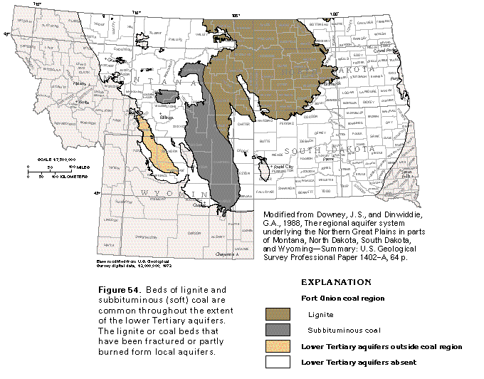
Lower Tertiary aquifers consist of sandstone beds within the Wasatch Formation of Eocene and Paleocene age and the Fort Union Formation or Group of Paleocene age. Both geologic units were deposited primarily in continental environments and consist of alternating beds of sandstone, siltstone, and claystone; both commonly contain beds of lignite and subbituminous coal (fig. 54). The area of the coal beds is known as the Fort Union coal region and contains a major part of the Nation's reserves of coal. The lignite or coal beds that have been fractured or partially burned after being ignited by lightning or wildfires form local aquifers. Most water in the lower Tertiary aquifers, however, is stored in and moves through the sandstone beds.
The thickness of the formations that compose the lower Tertiary aquifers is variable. The Fort Union Formation is as much as 3,600 feet thick in the Powder River Basin, but the Fort Union Group is much thinner in the Williston Basin. In northeastern Montana and western North Dakota, for example, the Fort Union is only about 300 feet thick. The thickness of permeable sandstone in the Fort Union in both basins, however, is much less than that of the formation. The sandstone beds of the Fort Union are more coarse grained and permeable in the Powder River Basin than the Williston Basin. The Wasatch Formation, which is only in the Powder River Basin, is as much as 1,000 feet thick. Not all the beds in the Wasatch yield water; like the Fort Union, most permeable beds in the Wasatch are sandstones.
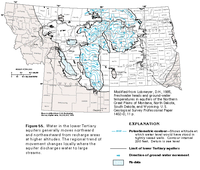
A map of the potentiometric surface of the lower Tertiary aquifers indicates the general movement of water is northward and northeastward from recharge areas in northeastern Wyoming, eastern Montana, and southwestern North Dakota (fig. 55). The water-level measurements used to construct this map are mostly from wells completed in the Wasatch Formation in Wyoming and the Fort Union Formation or Group elsewhere. The complex shape of the potentiometric contours is partly the result of topography; the higher altitudes of the potentiometric surface generally correspond to higher altitudes of the land surface. Some of the complexity, however, results from the influence of major streams, such as the Yellowstone and the Missouri Rivers. These streams are discharge areas for the lower Tertiary aquifers and coincide with low areas of the potentiometric surface. Water in the lower Tertiary aquifers commonly is under unconfined conditions. Locally, however, the water is confined by clay beds in the upper parts of the aquifers or by till or lacustrine clay where the aquifers are overlain by glacial deposits.
The upper Cretaceous aquifers of the Northern Great Plains aquifer system are exposed as a wide to narrow band that surrounds the lower Tertiary aquifers (fig. 49). These aquifers consist of sandstone beds in the Lance and the Hell Creek Formations and the Fox Hills Sandstone (fig. 50). The Lance Formation and the equivalent Hell Creek Formation range in thickness from about 350 to 3,400 feet. Both formations consist of interbedded sandstone, siltstone, claystone, and local thin beds of coal or lignite, all of which were deposited in a continental environment. The underlying Fox Hills Sandstone ranges from about 300 to 450 feet thick and is one of the most continuous water-yielding formations in the aquifer system. The Fox Hills consists primarily of sandstone that was deposited mostly in a deltaic to marine environment and contains local beds of siltstone and shale.
The shape of the potentiometric surface of the upper Cretaceous aquifers (fig. 56) closely resembles that of the overlying lower Tertiary aquifers (compare figs. 55 and 56). Water in the upper Cretaceous aquifers moves from aquifer recharge areas at higher altitudes toward discharge areas along major rivers where the potentiometric surface is lower. As shown by the arrows in figure 56, the general movement of water is northward in the Powder River Basin and northeastward in the Williston Basin. The complex shape of the potentiometric-surface contours indicates that the water in most places is under unconfined conditions. Because the shape of the water table generally conforms to that of the land surface, local high areas of the potentiometric surface correspond to high areas of the land surface. Likewise, the influence of major streams is reflected by low areas of the potentiometric surface.
The altitude of the potentiometric surface of the upper Cretaceous aquifers is similar to that of the overlying lower Tertiary aquifers in eastern Montana and western North Dakota and South Dakota (compare figs. 55 and 56). In these areas, no continuous confining unit separates the two groups of aquifers and water moves freely between the aquifers. By contrast, in Wyoming and parts of central Montana, the potentiometric surface of the lower Tertiary aquifers is as much as 400 feet higher than that of the upper Cretaceous aquifers, which indicates that confining units separate the aquifers. Under these conditions, some water probably leaks downward from the lower Tertiary aquifers through the confining units to recharge the upper Cretaceous aquifers.
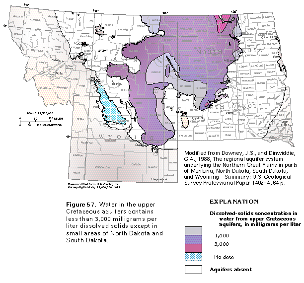
Water in the upper Cretaceous aquifers contains less than 3,000 milligrams per liter dissolved solids everywhere except for small areas in North Dakota and South Dakota where concentrations are as large as 10,000 milligrams per liter (fig. 57). Water with dissolved-solids concentrations of less than 1,000 milligrams per liter is mostly near the Black Hills Uplift and in smaller areas near the boundaries of the aquifers. The major dissolved ions in water from the upper Cretaceous aquifers are sodium, sulfate, and bicarbonate; locally, calcium and magnesium are dominant. In the small area in North Dakota where water in the upper Cretaceous aquifers contains more than 3,000 milligrams per liter dissolved solids, however, the water is a sodium chloride type. Even though the water contains dissolved-solids concentrations of less than 3,000 milligrams per liter in most places, large sodium concentrations make the water unsuitable for irrigation. Water from the upper Cretaceous aquifers provides domestic and livestock-watering supplies in large parts of Segment 8 and is the source of supply for several small communities in southeastern Montana and northwestern South Dakota.
The lower Cretaceous aquifers are separated from the overlying upper Cretaceous aquifers by several thick shales that form an effective confining unit. The Pierre Shale and its partial equivalents, the Lewis and the Steele Shales (fig. 50), are the thickest and most extensive formations of the confining unit. The Pierre Shale is as much as 3,000 feet thick in places and is the principal confining unit in North Dakota and South Dakota (fig. 49). Although thin sandstones are interbedded with the shales of the confining unit, the sandstones yield little water. Locally, they provide sufficient water for domestic supplies, but the water generally is highly mineralized. Recent studies indicate that water in storage in the Pierre Shale provides some recharge to the underlying upper Cretaceous aquifers, particularly where the shale is fractured.
Several sandstones compose the lower Cretaceous aquifers of the Northern Great Plains aquifer system (fig. 50). The principal water-yielding units are the Newcastle Sandstone (also called the Dakota Sandstone) and the Inyan Kara Group in the Williston Basin, and the Muddy Sandstone and the Inyan Kara Group in the Powder River Basin. The Fuson and the Lakota Formations cannot be separated in the southwestern part of the Powder River Basin where they are collectively mapped as the Inyan Kara Group. Locally, permeable parts of the Sundance, the Swift, the Rierdon, and the Piper Formations of Jurassic age yield small to moderate quantities of water to wells. These local aquifers in Jurassic rocks are included in the lower Cretaceous aquifers in this report.
The Newcastle Sandstone is only a few tens of feet thick where it crops out on the flanks of the Black Hills Uplift, but its subsurface equivalent, the Dakota Sandstone, is more than 400 feet thick in southeastern South Dakota. The Newcastle (or Dakota) Sandstone is absent in much of North Dakota, and the thickness of the Muddy Sandstone, which is its equivalent in Montana and Wyoming, is a few tens of feet. In many places, the Skull Creek Shale separates the Newcastle Sandstone from sandstones of the underlying Inyan Kara Group. The Inyan Kara Group is about 700 feet thick in central Montana, but the group merges eastward into the lower part of the Dakota Sandstone in eastern North Dakota and South Dakota. Most of the water-yielding sandstones included in the lower Cretaceous aquifers are of fluvial or deltaic origin.
Water in the lower Cretaceous aquifers is confined except in aquifer outcrop areas that encircle structural uplifts, such as the Black Hills Uplift and the Bighorn Mountains (fig. 49). In eastern North Dakota and South Dakota, the aquifers contain water under confined to semiconfined conditions; poorly permeable till and glacial-lake deposits overlie the aquifers in these areas. The lower Cretaceous aquifers contain water with dissolved-solids concentrations of greater than 3,000 milligrams per liter in most of North Dakota, because the water has moved along flow paths hundreds of miles long, has been in contact with aquifer minerals for a long time, and has partially dissolved the mineral material. Isotopic dating of water in these aquifers near their easternmost extent in South Dakota indicates that water locally entered the aquifers during Pleistocene glaciation.
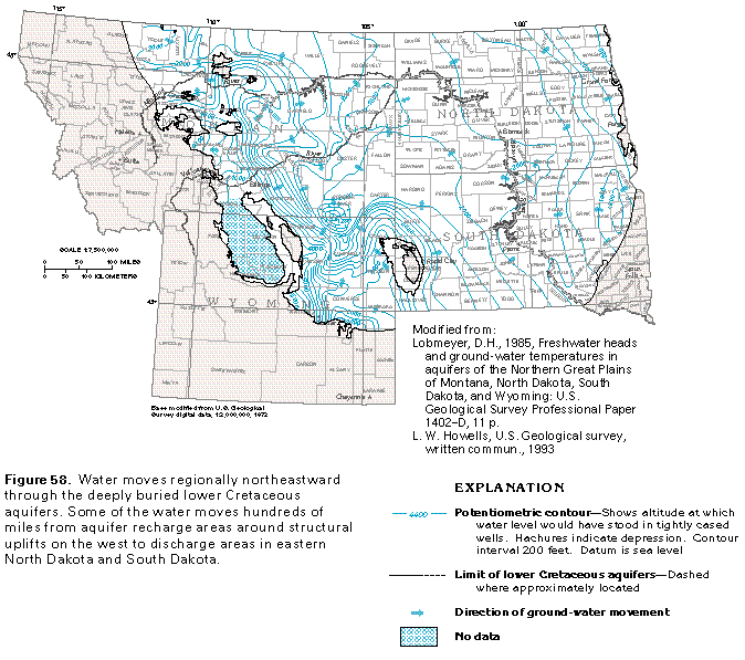
The general movement of water in the lower Cretaceous aquifers is northeastward from aquifer recharge areas at high altitudes to discharge areas in eastern North Dakota and South Dakota (fig. 58). The closely spaced contours near the structural uplifts in the western parts of the aquifer represent steep hydraulic gradients. As indicated by the widely spaced contours, the hydraulic gradient is much flatter in the Williston Basin where the aquifers are deeply buried and are as much as 10,000 feet below the land surface. The hydraulic gradient becomes slightly steeper in eastern North Dakota near aquifer discharge areas. The potentiometric surface of the lower Cretaceous aquifers is not as irregular as that of the lower Tertiary or upper Cretaceous aquifers (compare figs. 55, 56, and 58). This is because the lower Cretaceous aquifers generally are overlain by a thick, effective confining unit and do not discharge to streams except locally. The depressions in the potentiometric surface of the lower Cretaceous aquifers in eastern and southeastern Montana might be the result of petroleum withdrawal from deep oil reservoirs in these areas. When the oil is pumped from underlying geologic formations, pressure on the oil reservoir decreases. As a result, water might leak downward from the lower Cretaceous aquifers through confining units that underlie the aquifers and create an area of low hydraulic head in the aquifers. Another possibility is that the depressions represent water-level measurements from isolated sandstone beds that are not connected to the regional ground-water flow system of the lower Cretaceous aquifers.
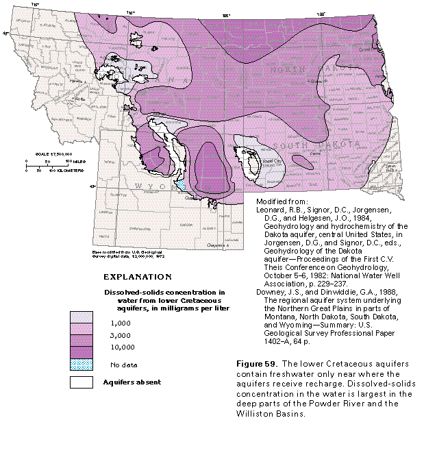
The lower Cretaceous aquifers are the most widespread aquifers in the Northern Great Plains aquifer system, but contain little freshwater (fig. 59). Water with dissolved-solids concentrations of less than 1,000 milligrams per liter (freshwater) is only in small areas in central and south-central Montana, and north and east of the Black Hills Uplift (fig. 59). Even though the water in the lower Cretaceous aquifers is slightly saline throughout most of South Dakota and a large area in southeastern North Dakota, the aquifers are the principal source of water for livestock watering and domestic supply because they are the shallowest consolidated-rock aquifers in these areas. Much of the slightly saline water is believed to result from upward leakage of highly mineralized water from underlying aquifers in Paleozoic rocks. Over about one-half of the lower Cretaceous aquifers (fig. 59), the water in the aquifers is moderately saline. The water is very saline or a brine in the deep parts of the Williston and the Powder River Basins.
Paleozoic aquifers in the Northern Great Plains aquifer system are divided into upper Paleozoic aquifers and lower Paleozoic aquifers (fig. 50). Although the Paleozoic aquifers extend over large areas of Segment 8, they are deeply buried in most places and contain little freshwater. Few water wells penetrate these aquifers, and much of what is known about them has been determined from data gathered from test holes drilled for oil and gas exploration.
Upper Paleozoic aquifers consist primarily of the Madison Limestone of Devonian and Mississippian age. In the Powder River Basin, the Madison is undivided; in the Williston Basin, however, it is separated into three formations and is called the Madison Group (fig 50). Sandstones of Pennsylvanian and Permian age, primarily the Tensleep Sandstone in the western parts of the Powder River Basin and sandstone beds of the Minnelusa Formation in the Williston Basin and the eastern part of the Powder River Basin, were treated as a separate aquifer by a regional study of the Northern Great Plains aquifer system. The sparse data available for the Pennsylvanian sandstones, however, show that they yield much less water than the Madison Limestone or Group, and contain freshwater only in local areas where the sandstones crop out. Pennsylvanian rocks are not considered to be a principal aquifer in this report. The Madison Limestone consists of marine limestone that contains some clay, chert, and anhydrite, and has been altered to dolomite in places. In the Williston Basin, the Lodgepole Limestone, which is the lowest formation in the Madison Group, mostly consists of limestone and dolomite beds; the overlying Mission Canyon Limestone consists of crystalline limestone with beds of dolomite and anhydrite; and the Charles Formation, which overlies the Mission Canyon Limestone in the deepest parts of the Williston Basin, chiefly consists of evaporite deposits and is a confining unit. In the subsurface, the dolomite is the most permeable rock type. The Madison Limestone or Group ranges in thickness from a featheredge at its limits to more than 2,800 feet in western North Dakota.
Where the Madison Limestone is exposed at the land surface, the carbonate rocks that compose the formation have been partly dissolved by circulating ground water. This dissolution can produce large openings in the rock, some of which become interconnected to form cave systems. Partial collapse of the roofs of the solution features create sinkholes and other types of openings that allow surface water to move into the limestone. The topography that forms where carbonate rocks contain sinkholes and caves is called karst topography. Karst features have been described in outcrop areas of the Madison Limestone in central Montana, north-central Wyoming, and western South Dakota. Several large springs issue from some of the solution conduits in the Madison. The Thermopolis hot springs system in central Wyoming discharges about 3,000 gallons per minute of geothermal water from the Madison Limestone. The water has become heated because it has circulated to great depths.
A map of the potentiometric surface of the upper Paleozoic aquifers (fig. 60) shows that the water moves regionally northeastward from recharge areas where the aquifers crop out adjacent to structural uplifts near the southern and western limits of the aquifer system. Locally, the water moves outward in all directions from the Black Hills Uplift and inward from all directions toward local depressions in the potentiometric surface in eastern Montana. These depressions are possibly the result of the production of oil and gas from deeper strata. Withdrawal of the oil and gas lowers the pressure in the hydrocarbon reservoir and can allow water to leak downward from the upper Paleozoic aquifers through confining units into deeper permeable zones. This leakage could locally reduce the hydraulic head in the upper Paleozoic aquifers and result in the small depressions. Water in the upper Paleozoic aquifers is confined everywhere except in recharge areas. Discharge is by upward leakage of water to the lower Cretaceous aquifers in eastern North Dakota and central South Dakota.
Water in the upper Paleozoic aquifers is fresh only in small areas at or near places where recharge enters the aquifers. The principal area of freshwater encircles the Black Hills Uplift in western South Dakota (fig. 61). The water quickly becomes slightly saline to saline as it moves downgradient from the recharge areas and into the Williston Basin. In the deep parts of the Williston Basin, the water is a brine that has dissolved-solids concentrations of greater than 300,000 milligrams per liter in a large area in western North Dakota. The presence of water with a dissolved-solids concentration that ranges from 3,000 to 10,000 milligrams per liter on the eastern (downgradient) side of the brine indicates that some water flows around the brine rather than through it. Mineralized water in the upper Paleozoic aquifers in central South Dakota leaks upward to the overlying upper Cretaceous aquifers and causes increased mineralization in the water in the shallower aquifers.
Lower Paleozoic aquifers consist of sandstone and carbonate rocks of Cambrian and Ordovician age (fig. 50). Although the rocks that compose these aquifers are widespread in Segment 8, they are, for the most part, deeply buried, commonly contain saline water or brine, and are important oil and gas reservoirs in deep parts of the Williston Basin. Only sparse data for the water-yielding characteristics of these rocks are available, and most of the data are for areas where the aquifers crop out or are buried at shallow depths. The principal geologic units that compose the lower Paleozoic aquifers are the Flathead Sandstone, sandstone beds of the Winnipeg Formation, limestones of the Red River and the Stonewall Formations, and the Bighorn and the Whitehead Dolomites (fig. 50). The combined thickness of these formations is more than 2,000 feet in the deep part of the Williston Basin, but the thickness of the lower Paleozoic aquifers is much less because the parts of the rocks that have minimal permeability or those that contain brine, oil, or gas are not considered to be aquifers. In much of the Powder River Basin, the upper and lower Paleozoic aquifers are hydraulically connected and locally are called the Madison aquifer system.
Sparse data indicate that the movement of water in the lower Paleozoic aquifers generally is northeastward (fig. 62). The water moves from aquifer recharge areas on the flanks of structural uplifts, across the Bighorn Basin and parts of the Williston Basin, and discharges to shallower aquifers in eastern North Dakota and central South Dakota. Although figure 62 shows an area of high altitude on the potentiometric surface of the aquifers in eastern Montana and western North Dakota, this area does not represent a recharge area. Rocks equivalent to the lower Paleozoic aquifers mostly contain brine or petroleum in this area, and the high potentiometric-surface altitudes probably represent measurements from isolated sandstone or limestone beds that are not connected to the main body of permeable rocks.
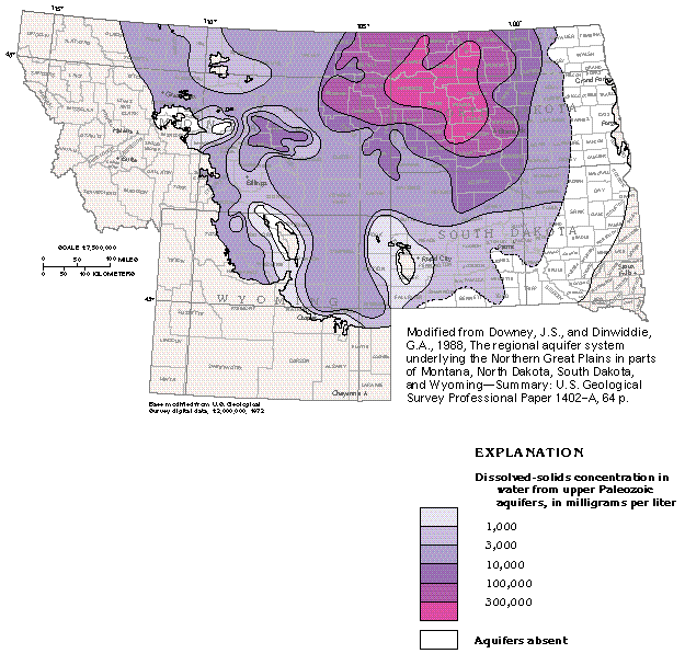
Lower Paleozoic aquifers contain freshwater only in a small area in north-central Wyoming and a somewhat larger area that surrounds the Black Hills Uplift (fig. 63). These aquifers contain slightly saline to moderately saline water throughout the southern one-half of their extent. In eastern Montana and western and central North Dakota, the aquifers contain brine that has dissolved-solids concentrations of greater than 100,000 milligrams per liter. Most of the water in the aquifers moves around the southeastern or northwestern margins of the body of brine. In a large area in central South Dakota, some of the slightly saline water in the lower Paleozoic aquifers leaks upward into shallower aquifers where the deeper aquifers pinch out eastward against Precambrian rocks.
The ground-water flow system in the Paleozoic aquifers of the Northern Great Plains aquifer system is summarized in figure 64. Recharge areas for the upper and lower Paleozoic aquifers are on the flanks of structural uplifts where the aquifers have been warped upward and subsequently exposed by erosion. Water generally moves northeastward from these recharge areas toward the deep parts of the Williston Basin. A large body of brine is in the deep parts of the Williston Basin where little or no water moves. Most of the water moves laterally around the margins of the brine and discharges to shallower aquifers in eastern North Dakota. Some of the water leaks upward through the unconsolidated deposits aquifers that overlie the Northern Great Plains aquifer system and ultimately discharges to springs, lakes, and streams in eastern North Dakota. Because the discharged water has traveled along flow paths that are hundreds of miles long, the water is highly mineralized and reaches the land surface as saline springs or seeps. Some water discharges from the lower Paleozoic aquifers in central South Dakota and eastern North Dakota by upward leakage to shallower aquifers.
UPPER COLORADO RIVER BASIN AQUIFER SYSTEM
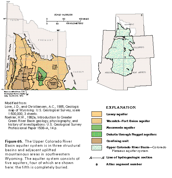
The Upper Colorado River Basin aquifer system in Segment 8 is in southwestern Wyoming and extends over about one-fourth of the State (fig. 65). The aquifer system underlies large areas of eastern Utah and western Colorado and small parts of northeastern Arizona and northwestern New Mexico and is described in detail for those four States in Chapter C of this Atlas. The Wyoming part of the aquifer system extends over about 20,000 square miles and is mostly in the Green River, the Great Divide, and the Washakie structural basins.
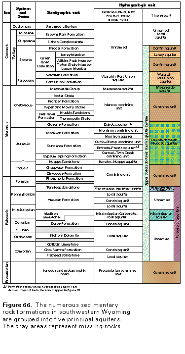
Layered sedimentary rocks in numerous geologic formations that range in age from Cenozoic to Paleozoic compose the aquifers of the Upper Colorado River Basin aquifer system in Wyoming. The formations are grouped into five principal aquifers in this report (fig. 66). From shallowest to deepest, they are the Laney aquifer; the Wasatch-Fort Union aquifer (together with the Laney aquifer, equivalent to the lower Tertiary aquifers elsewhere in Segment 8); the Mesaverde aquifer (equivalent to the upper Cretaceous aquifers); the Dakota through the Nugget aquifers (equivalent to the lower Cretaceous aquifers); and the Paleozoic aquifers. The Laney aquifer is exposed around the margins of the Green River Basin and the Washakie Basins (fig. 65). The Wasatch-Fort Union aquifer is the most widely exposed aquifer in southwestern Wyoming (fig. 65) and is at the land surface throughout most of the Great Divide Basin. Uplift has exposed the Mesaverde aquifer principally in the Rock Springs Uplift that separates the Washakie and the Great Divide Basins from the Green River Basin. The Dakota through the Nugget aquifers are exposed at the land surface only in small areas, and the Paleozoic aquifers are entirely in the subsurface.
The uppermost aquifer in the Wyoming part of the Upper Colorado River Basin aquifer system is the Laney aquifer. This aquifer consists of fractured sandstone beds assigned to the Laney Member of the Green River Formation. Although much of the Green River Formation is lacustrine clay, silt, or evaporite beds, all of which have minimal permeability, the sandstone beds of the uppermost Laney Member yield sufficient water for domestic and livestock-watering supplies. Water in the Laney aquifer is fresh to slightly saline. Locally, small yields can be obtained from wells completed in fractured lacustrine deposits of the Green River Formation.
The Wasatch Formation of Eocene and Paleocene age and the Fort Union Formation of Paleocene age compose the Wasatch-Fort Union aquifer. The lithology of the two formations is similar; the principal water-yielding beds are sandstones that are interbedded with shale, mudstone, and some coal beds. The upper part of the Wasatch Formation interfingers with shale and mudstone of the overlying Green River Formation around the margins of the Green River and the Washakie Basins. The Green River Formation is an effective confining unit in most places. Artesian pressure in the aquifer commonly is high enough to cause wells completed in the Wasatch Formation to flow. Locally, the Wasatch-Fort Union aquifer is very thick; for example, the aquifer is reported to be about 11,000 feet thick near Pinedale in Sublette County and about 7,000 feet thick near the center of the Great Divide Basin. Most of the freshwater in the Upper Colorado River Basin aquifer system is in the Wasatch-Fort Union aquifer, but the aquifer locally contains saline water where it is deeply buried.
Sandstone beds in the Mesaverde Group of Late Cretaceous age compose the Mesaverde aquifer (fig. 66). Shale beds form local confining units within the aquifer and the Lewis Shale locally overlies it in the Great Divide and the Washakie Basins. In most places, however, the Mesaverde aquifer and the overlying Wasatch-Fort Union aquifer are hydraulically connected. The Mesaverde aquifer is exposed at the land surface in a band that surrounds the Rock Springs Uplift (fig. 65). The aquifer contains freshwater only where it is exposed at the land surface and for a short distance downdip; water in the deeply buried parts of the aquifer is saline or briny. A thick confining unit composed mostly of shale in several geologic formations underlies the Mesaverde aquifer and hydraulically separates it from deeper aquifers in Mesozoic rocks.
The Dakota through the Nugget aquifers consist of several sandstone formations separated by confining units (fig. 66). These aquifers are exposed at the land surface only locally in southwestern Wyoming and contain very saline water or brine in most places. A thick confining unit of Triassic and Permian rocks underlies these aquifers and hydraulically separates them from the deeper Paleozoic aquifers.
The principal aquifers in Paleozoic rocks are the Tensleep Sandstone of Pennsylvanian and Permian age and the Madison Limestone of Devonian and Mississippian age (fig. 66). Sandstone, limestone, and dolomite beds of Pennsylvanian to Cambrian age also are local aquifers. Because they are deeply buried and contain saline water almost everywhere, the Paleozoic aquifers are not extensively used for water supply in southwestern Wyoming.
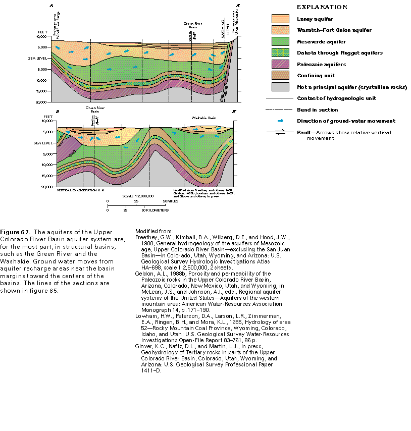
Ground water in all the aquifers of the Upper Colorado River Basin aquifer system moves from aquifer recharge areas toward the centers of the structural basins (fig. 67). Discharge from the aquifers is by upward leakage to shallower aquifers and, ultimately, to major streams. The ground-water flow system is simple where the geologic structure consists of broad basins and uplifts but is complex where the aquifers have been intensely folded and faulted.
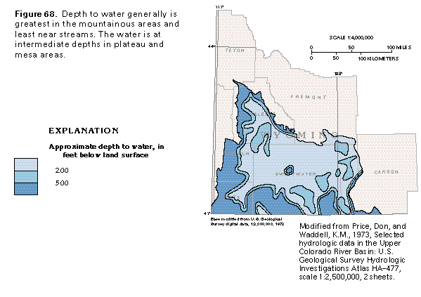
Water is less than 200 feet below the land surface in about three-fourths of the area of the aquifer system (fig. 68). Ground water is nearest the land surface near the major streams, which are discharge areas for the aquifers. In and near mountainous areas, depth to water ranges from 500 to 1,000 feet. Areas where water ranges from 200 to 500 feet below the land surface generally coincide with low plateaus. Where the topography is rugged, the depth to water is much more variable than can be shown by the generalized depth categories used to construct figure 68.
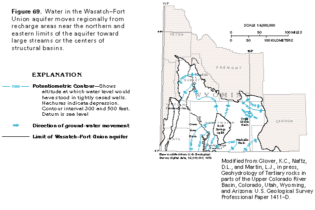
A map of the potentiometric surface of the Wasatch-Fort Union aquifer (fig. 69) shows that the regional movement of water in the eastern part of the aquifer is from recharge areas at basin margins toward the Great Divide Basin and southward into Colorado toward the center of the Washakie Basin. In the western part of the aquifer, water moves from recharge areas toward the Green River and its tributaries and toward the Flaming Gorge Reservoir. Where the aquifer is exposed at the land surface, much of the ground water moves along short flow paths from recharge areas to nearby small streams where it discharges. Local depressions on the potentiometric surface, such as the one in northeastern Sweetwater County, are the result of ground-water withdrawals.
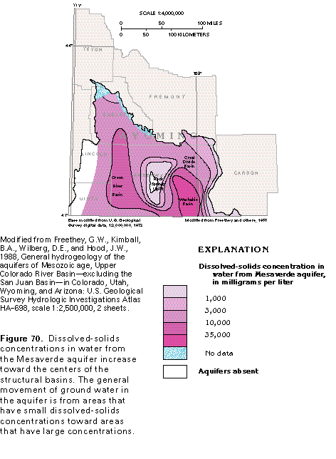
Movement of water in the Mesaverde aquifer is from recharge areas at the Rock Springs Uplift and near the eastern limit of the aquifer system, toward the centers of structural basins. A map of the distribution of dissolved-solids concentrations in water from the Mesaverde aquifer (fig. 70) shows that the aquifer contains freshwater in the recharge areas. The water becomes highly mineralized within a short distance downdip, and the dissolved-solids concentrations in the water increase toward the centers of the structural basins. Brine is reported from the Mesaverde aquifer in the Washakie Basin. In all basins, the dissolved-solids concentrations in the water increase downgradient and, thus, indicate the generalized direction of ground-water movement.
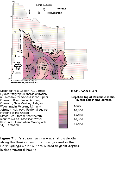
Paleozoic rocks are deeply buried in the structural basins of southwestern Wyoming (fig. 71); the depth to the top of these rocks is more than 25,000 feet in the deepest parts of the basins. The uppermost Paleozoic rocks are confining units, however (fig. 66), and the depth to the Pennsylvanian aquifer, which is the shallowest Paleozoic aquifer, is slightly greater than the depths shown in figure 71. Paleozoic aquifers receive little recharge, mostly contain saline water or brine, and have not been intensely studied.
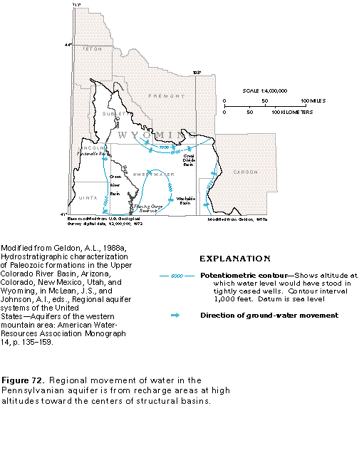
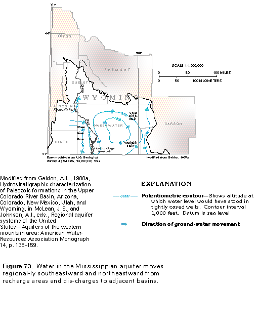
Sparse data show that water in the Pennsylvanian aquifer moves regionally toward the centers of structural basins from adjacent topographically high areas (fig. 72). Water discharges from this aquifer mostly by upward leakage to shallower aquifers. The water in the Pennsylvanian aquifer in the deepest parts of the Green River and the Washakie Basins is thought to move very slowly. Water in the Mississippian aquifer shows the same general trend of movement (fig. 73) as that in the Pennsylvanian aquifer. Much of the discharge from the Mississippian aquifer, however, appears to be by lateral movement of the water into adjacent structural basins to the southeast and northeast.
CENTRAL MIDWEST AQUIFER SYSTEM
The Central Midwest aquifer system in Segment 8 is only in small parts of southeastern South Dakota and southeastern Wyoming (fig. 74). The aquifer system extends southward and southwestward over parts of seven additional States (fig. 42) and is most extensive in Nebraska, Kansas, and Missouri, the States that compose Segment 3 of this Atlas. The aquifer system is discussed in detail in the chapter that describes that segment.
The Central Midwest regional aquifer system contains three subregional systems, only one of which, the Great Plains aquifer system, extends into Segment 8. The Great Plains aquifer system consists of two sandstone aquifers separated by a shale confining unit, all of which are in Lower Cretaceous rocks. The aquifer system is overlain by a thick sequence of Upper Cretaceous shale beds that are part of several geologic formations but which function together as a single confining unit, which is called the Great Plains confining system. The upper aquifer, which is called the Maha aquifer, consists chiefly of the Dakota, the Newcastle, or the Muddy Sandstones or equivalent rocks. The lower aquifer, which is called the Apishapa aquifer, consists mostly of the Cheyenne Sandstone or its equivalent, the Inyan Kara Group. The confining unit that separates the two aquifers is mostly the Skull Creek or the Thermopolis Shales or equivalent shale beds.
In southeastern South Dakota, water discharges upward from the Great Plains aquifer system to permeable beds in overlying unconsolidated deposits. The aquifer system contains water with dissolved-solids concentrations of 1,000 milligrams per liter or less in parts of Lincoln, Clay, and Union Counties, S. Dak. These small concentrations indicate a local ground-water flow system. Radiometric dates obtained from the water indicate that the aquifer system received some recharge during the Pleistocene Epoch when subglacial meltwater moved into the aquifer from areas of extremely high hydraulic head created by the weight of the glacial ice
NORTHERN ROCKY MOUNTAINS INTERMONTANE BASINS AQUIFER SYSTEM
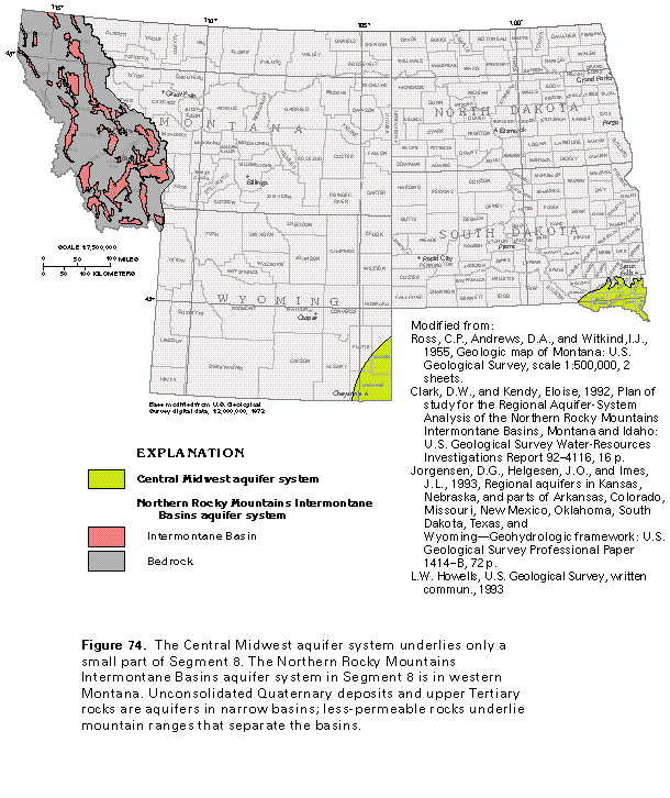
The part of the Northern Rocky Mountains Intermontane Basins aquifer system in Segment 8 is in western Montana (fig. 74). The part of the aquifer system that extends westward into Idaho is described in Segment 7 of this Atlas. Most of the basins that compose the aquifer system are not hydraulically connected, but share common hydrologic and geologic characteristics. Because the occurrence, movement, and quality of the water in these basins is controlled by the same hydrologic factors, the basins are treated together as an aquifer system. Results of detailed studies of example basins can be transferred to other basins with confidence that conditions will be similar.
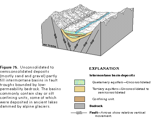
The Northern Rocky Mountains Intermontane Basins aquifer system consists primarily of unconsolidated-deposit aqui-fers of Quaternary sand and gravel that overlie upper Tertiary aquifers in structural basins (fig. 75). The upper Tertiary aquifers consist of unconsolidated to semiconsolidated deposits of sand and gravel and are difficult to distinguish from the Quaternary deposits. Lacustrine deposits of clay and silt commonly are in the unconsolidated Quaternary deposits, and clay and silt beds locally are in the Tertiary deposits. These fine-grained materials are confining units that are as much as 600 feet thick in some basins and locally create artesian conditions for the water in underlying aquifers. Lower Tertiary aquifers are in some basins, but these aquifers are deeply buried and poorly known. Together, the deposits in the basins are referred to as "basin-fill aquifers."Most of the basins are bounded by faults (fig. 75). The deposits and rocks that fill the basins are mostly alluvium derived from the weathering and erosion of consolidated rocks that underlie the mountains that border the basins, but locally the basin fill contains materials deposited by alpine glaciers. The igneous, metamorphic, and sedimentary rocks that underlie the mountains generally yield little water to wells.
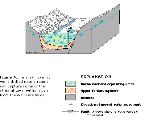
Recharge to the aquifer system is by precipitation that falls directly on basin floors and by snowmelt that runs off the surrounding mountains and is transported into the basins by tributary streams. The streams lose much of their water by infiltration into the basin-fill deposits. The basin-fill aquifers discharge primarily to streams that flow parallel to the long axes of the basins; some discharge is to springs and by withdrawals from wells. In small basins, the basin-fill deposits can be thin, and the basin, narrow (fig. 76). Withdrawals by wells located in such basins can capture some of the water that previously discharged to the stream. If withdrawals are great enough, then the hydraulic gradient can be reversed, and water can move from the stream to the aquifer and then to the pumping well.
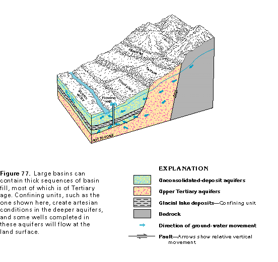
Hydrologic conditions in large basins can be more complex because such basins commonly are filled with thick sequences of sediment that contain clay confining units (fig. 77). Coalescing alluvial fans comprise much of the valley fill near mountain fronts. The alluvium was deposited by streams that flowed into the basins from the surrounding mountains. Terraces formed where the alluvium has been dissected in places by streams that flow within the basins. Older semiconsolidated to unconsolidated deposits are near the basin margins, whereas the basin centers contain younger, mostly unconsolidated deposits. These younger deposits are mostly stream-valley alluvium but also contain glacial deposits, such as clayey glacial-lake deposits that form confining units (fig. 77). Water beneath the confining units is under artesian pressure, and wells completed in the deeper aquifers will flow at the land surface where the pressure is sufficiently high. Water above the confining units is under unconfined conditions. If the confining units are near the land surface, then the water table can be shallow enough so that the land surface becomes water-logged.
Wells completed in the basin-fill aquifers of the Northern Rocky Mountains Intermontane Basins aquifer system locally yield as much as 3,500 gallons per minute but generally yield 50 gallons per minute or less. Yields adequate for domestic use and livestock-watering purposes can be obtained in most places from wells that are 200 feet deep or less. Deeper wells yield adequate volumes of water for irrigation, industrial purposes, and public supply. Several cities in western Montana obtain water supplies from the basin-fill aquifers.