INTRODUCTION
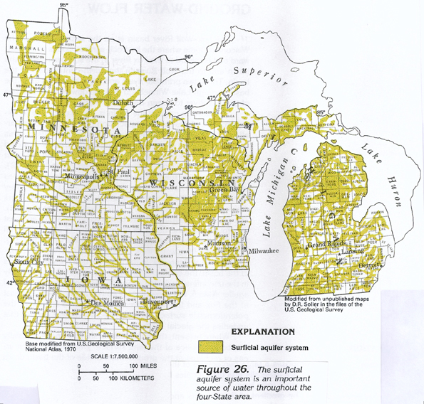
The surficial aquifer system is the uppermost and the most widespread
aquifer system in the four-State area (figure
26). This aquifer system consists primarily of material deposited
during multiple advances of continental glaciers from the north
during the Pleistocene and, possibly, the Pliocene Epochs. The
massive ice sheets planed off and incorporated soil and rock fragments
as large as boulders during advances and redistributed these materials
on the eroded land surface as water- or ice-laid deposits or both
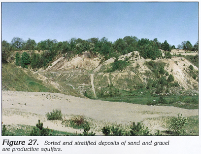
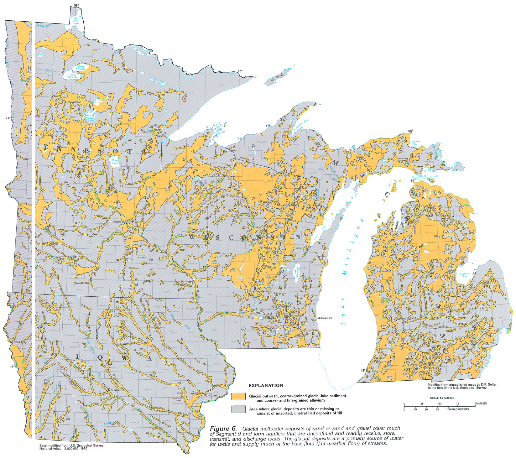
during retreats. Glaciofluvial or meltwater deposits, such as
outwash, lake sand, kames, and eskers, are sorted and generally
stratified deposits of sand or sand and gravel (fig.
27). These water-laid deposits, mapped in figure 6, generally
form permeable bodies of sand and gravel that are exposed at the
land surface and that readily receive, store, transmit, and discharge
water. They are a primary source of water for wells throughout
the four-State area and supply much of the base flow (fair-weather
flow) of streams. Ground and terminal moraines, which are the
dominant type of deposit laid down directly by ice, normally are
unsorted, unstratified deposits of clay, silt, sand, gravel, and
boulders called glacial till.
GEOLOGY AND WATER-YIELDING CHARACTERISTICS
Glacial deposits have a varied lithology and complex stratigraphy.
The multiple glaciations originated from different directions
and derived different materials from the predominant rock types
in their paths. In Minnesota, for example, ice lobes that advanced
from the northwest deposited gray calcareous till that contains
fragments of limestone and shale, whereas ice lobes that advanced
from the northeast deposited reddish, sandy, noncalcareous till.
In areas of the State where these deposits overlap, there is a
variable mixture of both types of till.
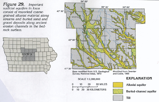
Iowa is covered largely by glacial deposits of older ice advances that are rich in clay and, thus, have minimal permeability. Reworked coarse-grained alluvial material along present stream valleys and buried former stream valleys, which were eroded into the bedrock surface, forms the only important surficial aquifers in the State.
Ice advances across Wisconsin and Michigan encountered vast areas of sandstone and crystalline bedrock in the northern parts of these States. Fragments of these rocks were transported and deposited farther to the south as extremely permeable, sandy material that forms productive aquifers. Where dolomitic rocks were encountered by the ice, the derived material is calcareous and rich in clay.
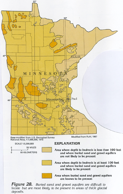
Buried deposits of permeable sand and gravel are present throughout the glaciated area where multiple ice advances occurred. Outwash or alluvium or both and other permeable deposits from earlier glaciation were covered by less-permeable deposits from succeeding advances or possibly from a readvance of the same glacier. These buried permeable deposits are generally confined aquifers that yield small to large quantities of water depending on their size. The buried deposits are difficult to locate as they normally have no surface expression. The known buried permeable deposits in Minnesota are shown in figure 28, and most commonly are present in areas of thick glacial deposits. In Iowa, buried permeable deposits typically are present along ancient erosion channels in the bedrock surface, as indicated in the example shown for central Iowa in figure 29.
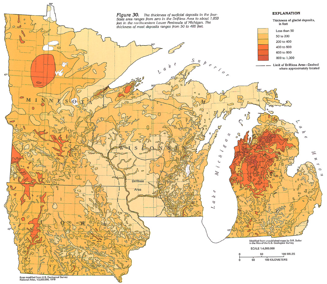
Glacial deposits in the four-State area generally range from 50 to 400 feet in thickness, but in some areas such as the northern part of the Lower Peninsula of Michigan they attain thicknesses of as much as 1,000 feet (fig. 30). In large areas surrounding Lakes Superior and Michigan and in northeastern Minnesota, northern Wisconsin, and the Upper Peninsula of Michigan, glacial deposits are generally less than 50 feet thick. This might be related to the paucity of rock material available for transport by the ice from the hard crystalline rocks of that area. A large area in northeastern Iowa, southwestern Wisconsin, and southeastern Minnesota is characterized by the almost complete lack of surficial deposits (fig. 30). This is the Driftless Area, which was not glaciated by any of the ice advances. Most of the Driftless Area has no glacial deposits except for clay, silt, and sand deposited in ephemeral glacial lakes and alluvial material that was transported into the major stream valleys by glacial meltwater and deposited.
Potential yields of wells completed in permeable glacial deposits in the four-State area might be about 500 gallons per minute where the deposits are thickest, such as in the northern part of the Lower Peninsula of Michigan and along major alluvial stream valleys, such as the Mississippi and the Wisconsin Rivers. Outwash deposits might yield about 500 gallons per minute to wells in Wisconsin and Michigan and lesser quantities in Minnesota. In broad areas of each State, wells completed in till might yield from 1 to 10 gallons per minute; even though it is only slightly permeable, the till generally yields small quantities of water to domestic wells.
Ground-water movement in glacial deposits in Segment 9 is a function of topography (gradient); type, permeability, and thickness of deposits; and the volume of recharge resulting from precipitation. Because these conditions are variable and extremely complex throughout Segment 9, an example basin is presented, and hydrogeology, ground-water movement, surface-water/ground-water relations, yield, and water quality are discussed to characterize the surficial aquifer system in the segment. The Fox-Wolf River basin in northeastern Wisconsin was chosen as a typical basin.
GROUND-WATER FLOW
The Fox-Wolf River basin is on the eastern flank of the Wisconsin
Dome where the bedrock surface slopes southeastward and eastward
to the Fox River in the southern part of the basin and to the
Wolf River in the north-central part of the basin. These two principal
rivers and their tributaries drain the basin through Lake Winnebago
and the downstream reaches of the Fox River to Green Bay (Lake
Michigan).
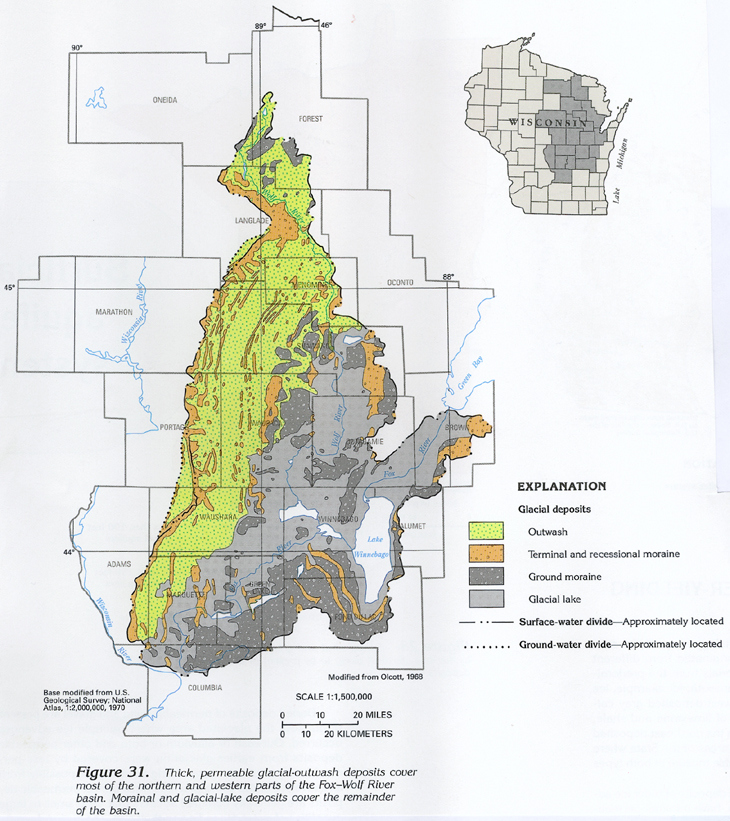
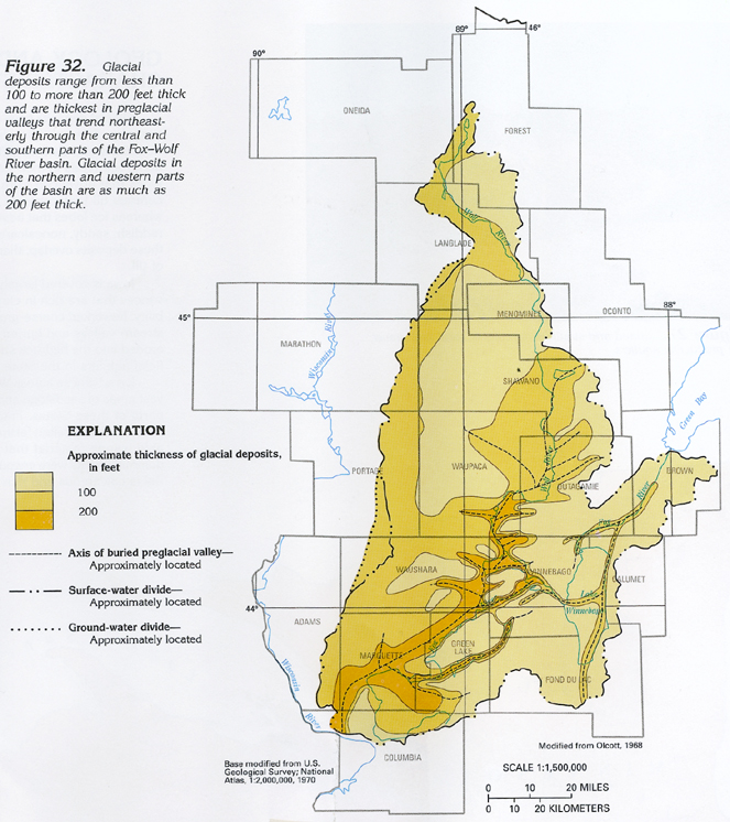
The western edge of the basin is bordered by the terminal moraine of Wisconsinan glaciation (fig. 31), which is paralleled to the east by numerous recessional moraines. This northwestern part of the basin is largely covered by stratified outwash deposits of permeable sand and gravel (fig. 31) that range in thickness from a few to more than 200 feet (fig. 32). The mainstem of the Fox River and the downstream reaches of the Wolf River flow along the course of a deep bedrock valley that has been filled with fine-grained glacial-lake sediments that range in thickness from 100 to about 200 feet (fig. 32). The glacial-lake sediments are bordered on the south and east by ground-moraine deposits of unsorted and unstratified till (fig. 31) that are generally less than 100 feet thick (fig. 32).
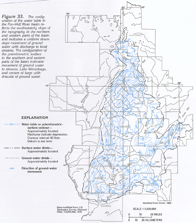
A map of the water-level surface in the Fox-Wolf River basin is shown in figure 33. In the northern and the western parts of the basin, the contours represent the water table principally in the unconfined outwash deposits that comprise the surficial aquifer system, which overlies crystalline rocks. South and east of the Fox and the Wolf Rivers, the contours represent the potentiometric surface in a confined sandstone aquifer that underlies the glacial deposits.
Where present, the water table is shallow and is generally a subdued replica of the land surface. Water moves from areas of recharge at the ground-water divide of the basin down the hydraulic gradient to discharge into local streams, where it comprises a large percentage of the base flow. These flow paths are generally less than 4 miles long and are commonly less than 1 mile long.
The gradient of the streams and the water table in the northern and western parts of the basin reflect the relatively steep slope of the topography in these areas. Streams flow southeastward directly downslope (fig. 33). The water throughout the outwash deposits also generally flows downslope perpendicular to the contours on the water table as shown by the arrows in figure 33.
The surface-water divide on the western side of the basin delineates the surface-water basin and follows the Wisconsinan terminal moraine (figs. 31, 32, and 33). Because of the sandy character of the morainal deposits, parts of the moraine are so permeable that the water table is not affected by the topography. Consequently, the ground-water basin is delineated by a ground-water divide farther to the west (figs. 31, 32, and 33).
An area of almost flat topography along the mainstem of the Fox and Wolf Rivers is an area of ground-water discharge. Ground water moves to the streams and to extensive wetlands in this area of low relief. The low topographic relief is reflected in the slight gradient of the water table (fig. 33).
Although the potentiometric surface south and east of the Fox and the Wolf Rivers represents hydraulic heads in the underlying sandstone aquifer, hydraulic heads in the overlying glacial deposits are similar; therefore, the configuration of potentiometric-surface contours generally is similar to that of the water-table contours in the glacial deposits. In the surficial and the sandstone aquifers, water movement is toward the two principal rivers, Lake Winnebago, and the five cones of depression shown in figure 33, which are caused by withdrawals of ground water. Locally, water in the surficial aquifer also moves downward to recharge the sandstone aquifer.
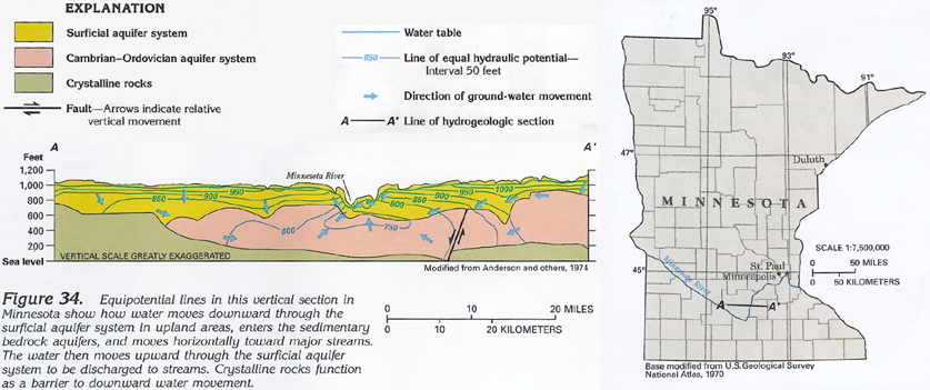
The surficial aquifer system throughout the four-State area not only functions as a storage reservoir for recharge from precipitation, but, in most places, water moves downward through the aquifer system to recharge underlying bedrock aquifers. Conversely, in some places, ground water moves upward from underlying bedrock aquifers into the surficial aquifer system and then moves to streams where it is discharged. The hydrogeologic section in figure 34 illustrates water movement in the surficial aquifer system and bedrock aquifers adjacent to the Minnesota River southwest of Minneapolis-St. Paul, Minn. The equipotential lines show that the hydraulic gradient is upward in the immediate vicinity of the Minnesota River but downward elsewhere. Water from the land surface moves downward to the water table in the surficial aquifer. From there, it moves downward into bedrock aquifers on each side of the river. The water then moves horizontally toward the river in response to the hydraulic gradient in both the surficial aquifer system and the bedrock aquifers. Near the river, the water follows an upward gradient and moves from the bedrock aquifers upward through the surficial aquifer system into the river where it is discharged. Ground-water circulation does not extend into Precambrian crystalline rocks that generally have minimal permeability and function as a barrier to water movement. This pattern of ground-water circulation is typical in the four-State area.
GROUND-WATER AND SURFACE-WATER INTERACTION
The surficial aquifer system is hydraulically connected to streams
because of its shallow depth, ease of recharge by precipitation,
and short ground-water flow systems. The degree of this connection,
however, is affected by the permeability of the deposits comprising
the aquifer. The most permeable deposits have the greatest connection
to streams, but the connection decreases with decreasing permeability;
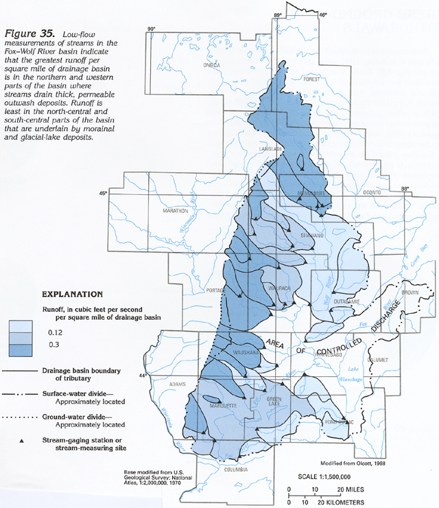
for example, in figure 35, runoff,
expressed in cubic feet per second per square mile of drainage
basin, is plotted for numerous small drainage basins in the Fox-Wolf
River basin during a low-flow period. The greatest runoff, which
is more than 0.3 cubic foot per second per square mile of basin,
generally is in the northern and the western parts of the basin,
which are underlain by permeable, thick outwash (figs.
31, 32). The least runoff, which
is less than 0.12 cubic foot per second per square mile of basin,
generally is in the east and south-central parts of the basin,
which are underlain by poorly permeable morainal and glacial-lake
deposits (fig. 31).
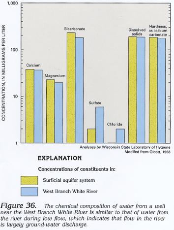
Another indication of the relation of ground water to surface water is shown by a comparison of the chemical composition of samples of ground water collected from a well near the West Branch White River in western Waushara County with samples collected from the river during low flow (fig. 36). The similar concentrations of each constituent indicate that the low flow of the stream is composed almost entirely of ground-water discharge.
Thus, in Segment 9, ground-water discharge from the surficial aquifer system sustains the low flow of streams, and the greatest low flows occur in areas underlain by permeable, thick, glacial deposits. Low flows are less in areas underlain by less permeable glacial deposits.
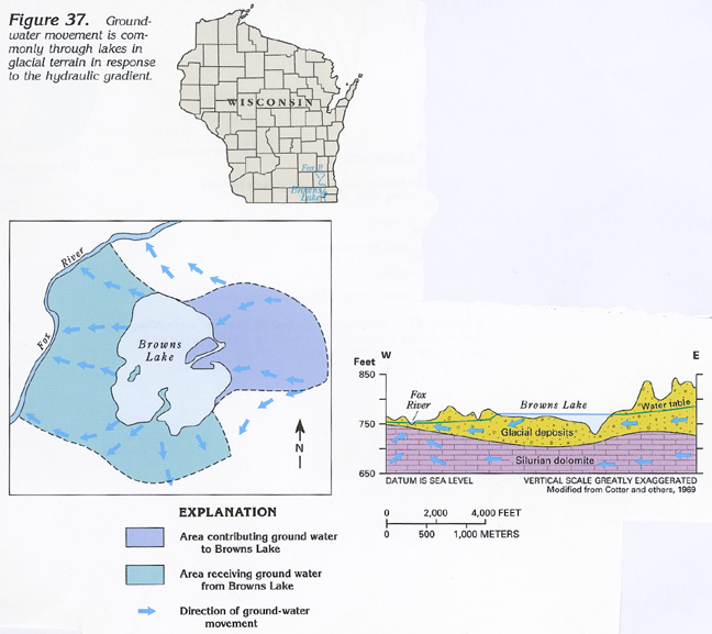
An important aspect of ground-water movement in the surficial aquifer system is the relation of ground water to lakes. About 25,000 lakes that formed during glaciation are present just in Minnesota and Wisconsin. The lakes generally are an extension of the water table in the surrounding surficial aquifer system. Thus, water from the surficial aquifer system moves into the lake on the upgradient side and moves back into the aquifer system as recharge from the lake on the downgradient side; for example, Browns Lake in southeastern Wisconsin (fig. 37) receives ground-water discharge from the surficial aquifer system along the eastern shore but loses water to the aquifer system along the southern and the western shores as the ground water moves westward to be discharged to the Fox River. This relation is typical of ground-water movement around lakes in the glaciated part of Segment 9.
RELATION OF POTENTIAL WELL YIELDS AND WATER QUALITY TO TYPE
OF GLACIAL DEPOSITS
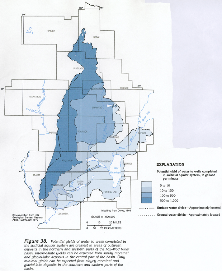
Potential yields of wells completed in the surficial aquifer system
typically are largest in the most permeable glacial deposits and
smallest in the least permeable glacial deposits. Potential well
yields of 500 to 1,000 gallons per minute can be expected from
outwash deposits in the northern and the western parts of the
Fox-Wolf River basin, as shown in figure
38. Potential well yields from sand in glacial-lake deposits
in the central part of the basin are variable and range from 10
to 500 gallons per minute. Potential well yields of only 5 to
10 gallons per minute can be expected from the morainal and glacial-lake
deposits in the southern and eastern parts of the basin where
these deposits contain little sand and have low permeability.
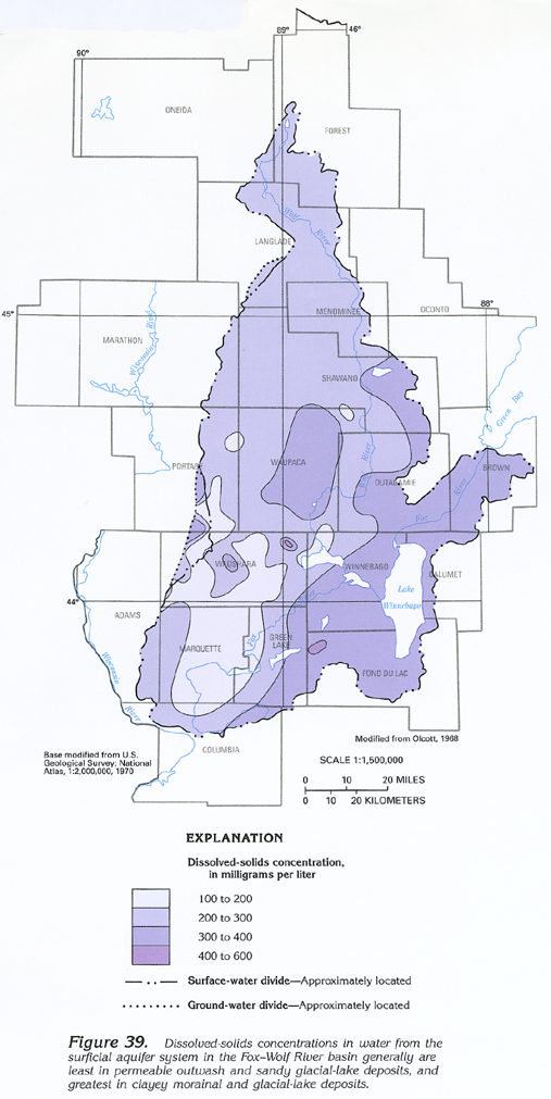
The chemical quality of water in the surficial aquifer system also is affected by the permeability of the glacial deposits. The smallest concentrations of dissolved solids (100-200 milligrams per liter) in ground water in the Fox-Wolf River basin generally are in areas underlain by outwash and sandy glacial-lake deposits in the northern and the southwestern parts of the basin (fig. 39). The largest concentrations (400-600 milligrams per liter) are in two small areas underlain by clayey morainal and glacial-lake deposits in the south-central part of the basin.
FRESH GROUND-WATER WITHDRAWALS
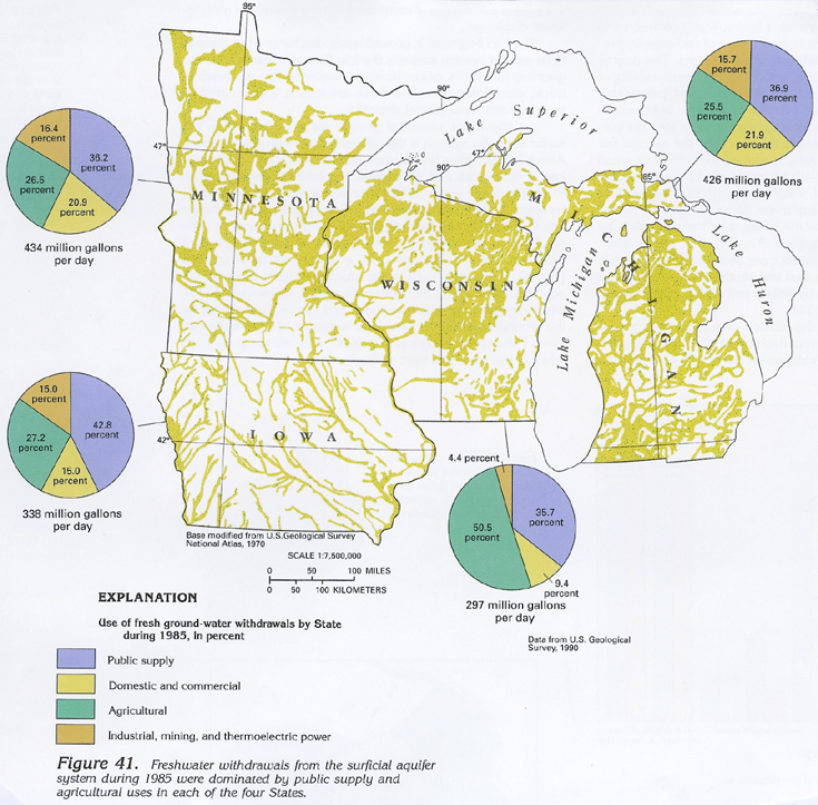
Withdrawals of freshwater from the surficial aquifer system in
Segment 9 during 1985 were about 1,495 million gallons per day
(fig. 40). Public supply and agricultural
withdrawals accounted for two-thirds of the total; domestic and
commercial, and industrial, mining, and thermoelectric-power withdrawals
comprised the remaining one-third. Withdrawals during 1985, in
million gallons per day, for each of the four States and the percentage
withdrawn for each use category are shown in figure
41. The largest rates of withdrawal from the surficial aquifer
system were in Minnesota and Michigan with 434 and 426 million
gallons per day withdrawn, respectively. This probably reflects
the generally small areal extent and less productive nature of
the bedrock aquifers in the two States. The less productive character
of the surficial aquifer system in Iowa and the presence of productive
bedrock aquifers in Iowa and Wisconsin account for the smaller
withdrawals of 338 and 297 million gallons per day from Iowa and
Wisconsin, respectively.