INTRODUCTION
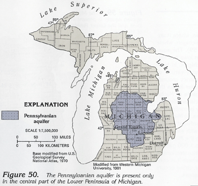
The Pennsylvanian aquifer is present only in the central part of the Lower Peninsula of Michigan (fig. 50), where it is called the Grand River-Saginaw aquifer and forms a major source of water for municipal, industrial, and domestic supply. The aquifer consists of sandstone with some interbedded shale. The central part of the Pennsylvanian aquifer is overlain by a confining unit in rocks of Jurassic age, but, elsewhere, the aquifer subcrops at the bedrock surface under the surficial aquifer system that is the principal source of recharge.
HYDROGEOLOGY
Rocks of Pennsylvanian age are present in only two parts of the
four-State area-in much of the southwestern part of Iowa and the
central part of the Lower Peninsula of Michigan. In Iowa, Pennsylvanian
rocks are not an aquifer; rather, they overlie and confine older,
more permeable rocks and underlie, in part, the Cretaceous aquifer.
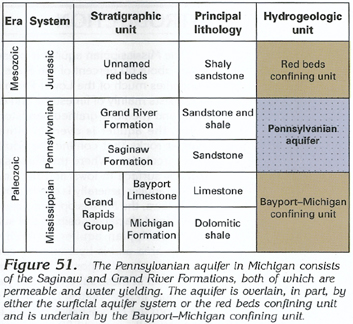
In Michigan, Pennsylvanian rocks, which consist of the Grand River
and the Saginaw Formations (fig. 51),
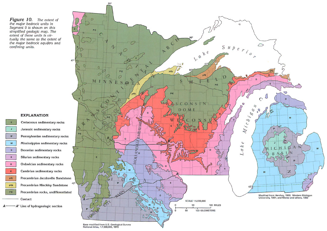
form a major and productive aquifer. They occupy a central position
in the Michigan Basin (fig. 10) and are the youngest bedrock in
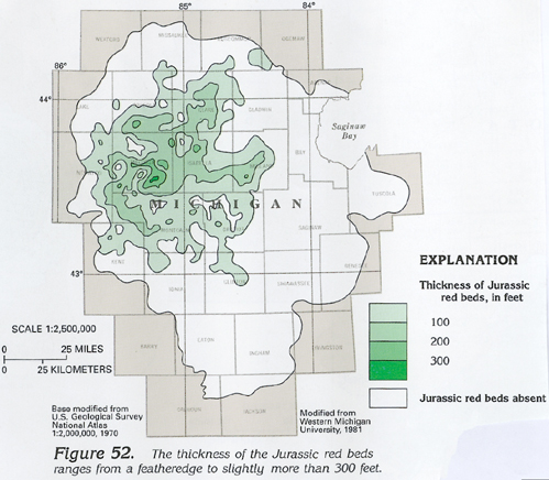
that basin except for a thin, red, sandy, shaly sandstone formation
(fig. 51) of Jurassic age that overlies
part of the Pennsylvanian aquifer. These Jurassic red beds range
from a featheredge to slightly more than 300 feet in thickness
(fig. 52). They are hydrologically
significant only as a confining unit for the Pennsylvanian aquifer.
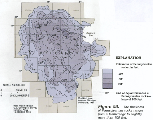
In Michigan, Pennsylvanian rocks consist of sandstone and siltstone with interbedded shale, limestone, coal, and gypsum. They range in thickness from a featheredge to a maximum of slightly more than 700 feet (fig. 53) but generally are less than 300 feet thick. The Grand River Formation (fig. 51) is a sandstone that fills erosional valleys in the underlying Saginaw Formation. The Saginaw Formation (fig. 51) consists of sandstone and siltstone in the Lansing area and fine-grained sandstone and siltstone interbedded with shale, limestone, coal, and gypsum in the Saginaw Bay area. The Saginaw Formation is extensively eroded and variable in thickness. Sandstone beds of the Grand River Formation generally are hydraulically connected with the underlying Saginaw Formation, and the two formations comprise the Pennsylvanian aquifer.
The Pennsylvanian aquifer is most productive where it is overlain by, and hydraulically connected with, the surficial aquifer system. The thickness of the Pennsylvanian aquifer also affects well yields; the aquifer yields moderate quantities of water where it is thickest. Thirty-four specific-capacity values reported for the Pennsylvanian aquifer in the Lower Peninsula of Michigan ranged from 1 to 99 gallons per minute per foot of drawdown, and eight transmissivity values ranged from 3,000 to 37,000 feet squared per day. Two reported values of the coefficient of storage were 9X10⁻⁵ and 3X10⁻⁴, which indicate confined conditions.
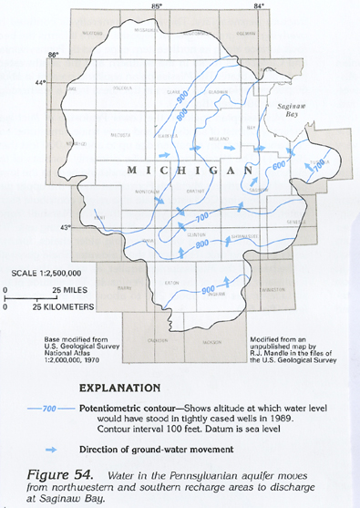
Recharge to the Pennsylvanian aquifer is from water that percolates downward through the surficial aquifer system and confining units overlying the aquifer. In the aquifer, water moves mostly horizontally along flow paths of 50 to 100 miles in length from areas where the hydraulic head is about 900 feet above sea level in the northwestern and southern parts toward the center of the aquifer and then northeastward to Saginaw Bay, where the water is discharged at an altitude of about 600 feet above sea level (fig. 54). The occurrence of saltwater in the lower part of the aquifer in places where it is covered by Jurassic red beds indicates that water is moving more slowly in that area. Discharge of the saltwater from the aquifer in the Saginaw Bay area indicates some movement of water through the saltwater zone of the aquifer. The principal movement, however, might be in the upper part of the aquifer and on the periphery of the saltwater zone.
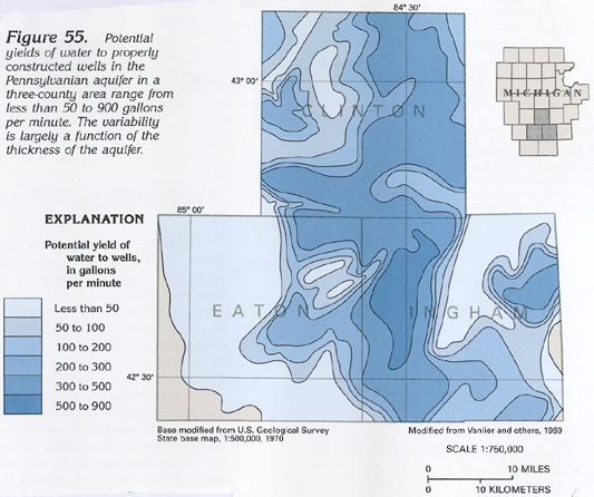
Estimated potential well yields from the Pennsylvanian aquifer in the three-county example area of Clinton, Eaton, and Ingham Counties range from less than 50 to 900 gallons per minute (fig. 55), depending on thickness, fracturing, and degree of interconnection with the overlying surficial aquifer system.
GROUND-WATER QUALITY
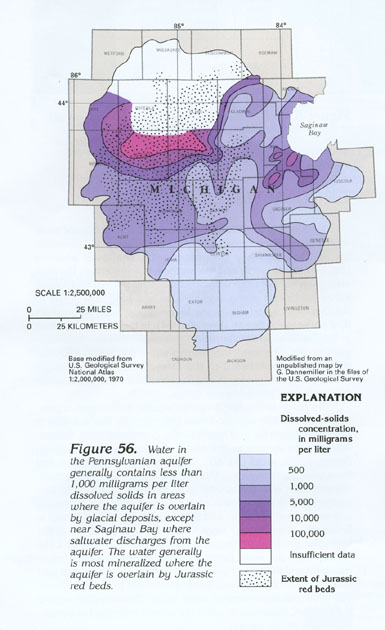
Water from the Pennsylvanian aquifer generally is salty (dissolved-solids
concentrations in excess of 1,000 milligrams per liter); the average
dissolved-solids concentrations is 1,600 milligrams per liter,
but, in areas where the aquifer subcrops beneath the surficial
aquifer system, the water is fresh (dissolved-solids concentrations
range from 300 to 700 milligrams per liter). Where the aquifer
is deeply buried, however, and in areas where it is overlain by
Jurassic red beds, wells commonly yield saltwater with dissolved-solids
concentrations that range from 1,000 to about 100,000 milligrams
per liter, as shown in figure 56.
In the area near Saginaw Bay, where ground water is discharged
from the Pennsylvanian aquifer,the water is salty because of its
long residence time in the aquifer and because of freshwater mixing
with saltwater at depth.
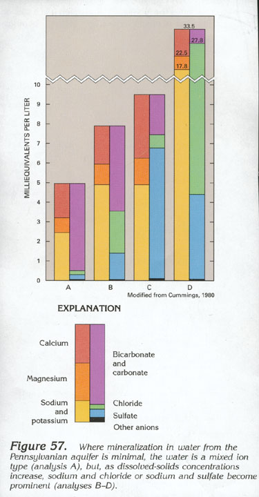
Freshwater in the Pennsylvanian aquifer tends to be of a mixed ion type, as shown in figure 57. Conversely, saltwater in the Pennsylvanian aquifer tends to be a sodium chloride type.
FRESH GROUND-WATER WITHDRAWALS
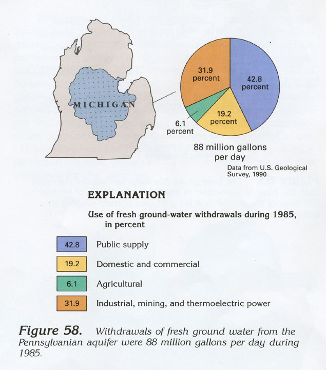
Total fresh ground-water withdrawals from the Pennsylvanian aquifer
were 88 million gallons per day during 1985 (fig.
58). Most of the water, 42.8 percent, or 37.7 million gallons
per day, was used for public supply; 19.2 percent, or 16.9 million
gallons per day, was used for domestic and commercial purposes;
6.1 percent, or 5.4 million gallons per day, was used for agricultural
purposes; and 31.9 percent, or 28 million gallons per day, was
used for industrial, mining, and thermoelectric-power purposes.