INTRODUCTION
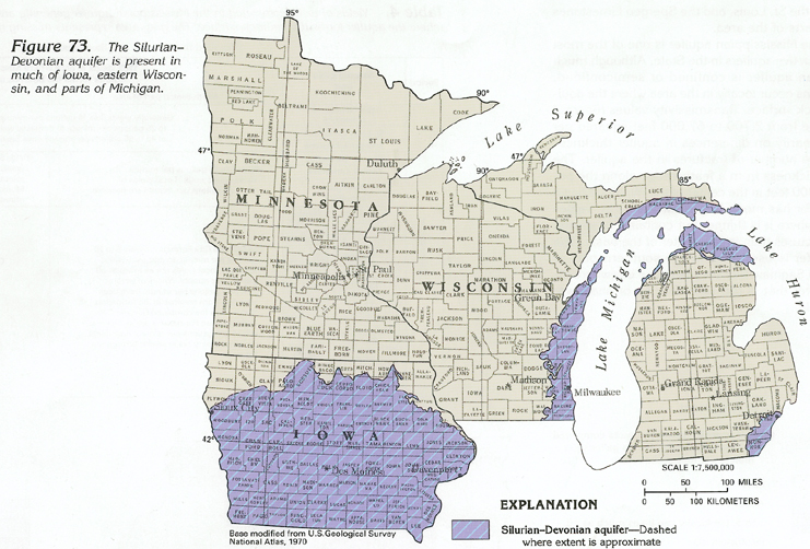
The Silurian-Devonian aquifer is present in Iowa, Wisconsin, and Michigan (fig. 73). The aquifer consists mostly of limestone and dolomite in all three States, but locally contains interbedded shale and evaporite beds. The Silurian-Devonian aquifer underlies all but the northern part of Iowa, or about 90 percent of the State (fig. 73), and forms the bedrock surface in about 20 percent of the State. In Wisconsin, the aquifer forms the bedrock surface in about 20 percent of the State along its eastern edge adjacent to Lake Michigan (fig. 73). Although Silurian and Devonian rocks are present throughout the Lower and part of the Upper Peninsula of Michigan, they form the bedrock surface only in the southeastern Upper Peninsula and the northern and the southeastern parts of the Lower Peninsula where they form an aquifer (fig. 73). The Silurian-Devonian aquifer generally is overlain by the surficial aquifer system where the aquifer forms the bedrock surface; in small areas, however, the aquifer crops out at the land surface.
Where the Silurian-Devonian aquifer is unconfined but is overlain by the surficial aquifer system, dissolution has resulted in extensive development of karst features, and the aquifer is susceptible to contamination from the land surface. Contaminated water can either move downward through the overlying glacial deposits or enter the Silurian-Devonian aquifer directly in outcrop areas. In confined areas, the aquifer is protected from contamination by the overlying confining units; where it is confined, the aquifer commonly contains saltwater with large dissolved-solids concentrations that increase with depth and distance downdip.
HYDROGEOLOGY
The average thickness of the carbonate rocks that compose most
of the Silurian-Devonian aquifer is about 300 to 400 feet;
the aquifer also contains some sandstone, shale, and evaporite
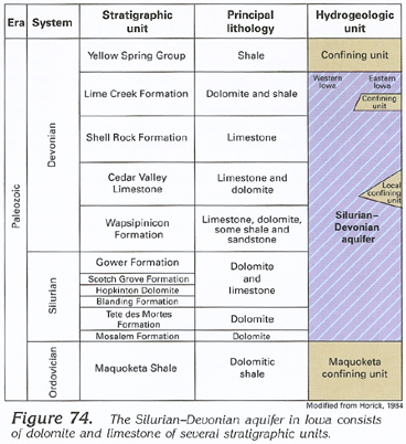
beds. In Iowa, shale units in the Yellow Spring Group (fig.
74) confine the aquifer except where it forms the bedrock
surface and where shale beds in the Lime Creek Formation form
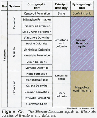
a confining unit within the aquifer. In Wisconsin, the aquifer
consists largely of Silurian rocks and is unconfined or partially
confined by fine-grained sediments in the surficial aquifer system
or by shale of the Devonian Kenwood Formation (fig.
75) which occurs only in a small area north of Milwaukee and
adjacent to Lake Michigan. In Michigan, the Silurian-Devonian
aquifer is unconfined where it forms the bedrock surface or is
covered by the surficial aquifer system. The aquifer is confined
as it dips beneath the Ellsworth and the Antrim Shales (fig.
76). The Silurian-Devonian aquifer is confined at its
base by the Maquoketa confining unit (figs.
74, 75) in Iowa and Wisconsin
and by equivalent shale and carbonate rocks of the Cataract and
the Richmond Groups (fig. 76) in
Michigan.
In the carbonate rocks of the Silurian-Devonian aquifer,
water movement is primarily through secondary openings, such as
joints, fractures, and bedding-plane openings, many of which have
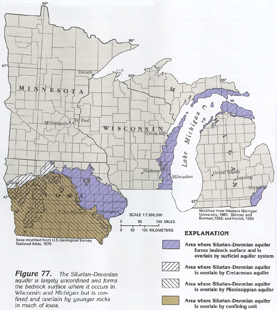
been enlarged by dissolution. In areas where the aquifer forms
the bedrock surface and is overlain by the surficial aquifer system
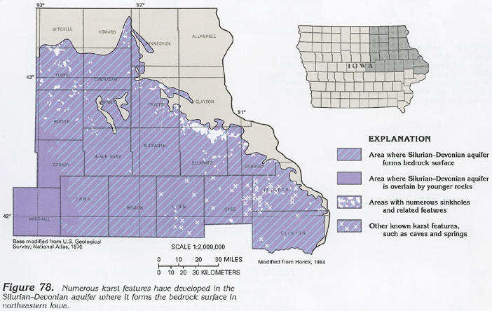
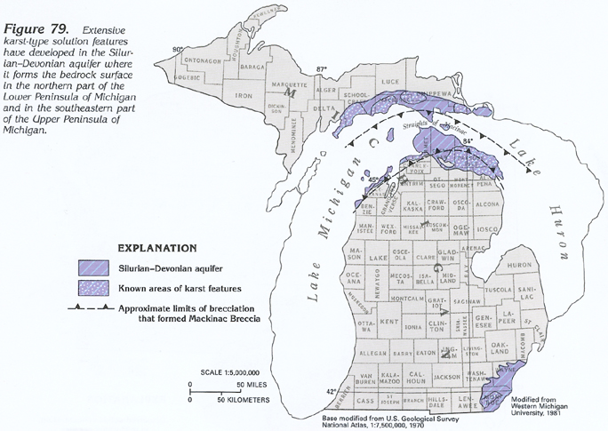
(fig. 77), especially in northeastern
Iowa, the northern part of the Lower Peninsula of Michigan, and
the southeastern part of the Upper Peninsula of Michigan, dissolution
has resulted in extensive areas of karst features, such as sinkholes
and caves (figs. 78, 79).
Dissolution of evaporite beds in the Salina Group of Michigan
also has caused collapse of overlying Silurian and Devonian rocks
and has produced the Mackinac Breccia (figs.
76, 79) which has increased the
permeability of the aquifer. In areas where the aquifer is overlain
by thick confining units (fig. 77),
which impede recharge
to the aquifer, neither the formation of karst features nor the
dissolution along joints, fractures, and bedding planes have occurred.
In these areas, the aquifer tends to have minimal permeability.
The permeability of the Silurian-Devonian aquifer and the movement of water through the aquifer are greatest where the dissolution of the carbonate rocks is greatest; for example, transmissivity values for the aquifer in Iowa decrease from about 360,000 feet squared per day in northeastern Iowa, where the aquifer forms the bedrock surface and is overlain by the surficial aquifer system, to only about 1,200 feet squared per day in areas where the aquifer is confined. Well yields, which generally range from 100 to 500 gallons per minute, therefore, are more dependent on the degree of secondary porosity developed in the carbonate rocks rather than on the thickness of the rocks.
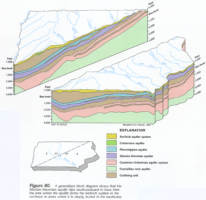
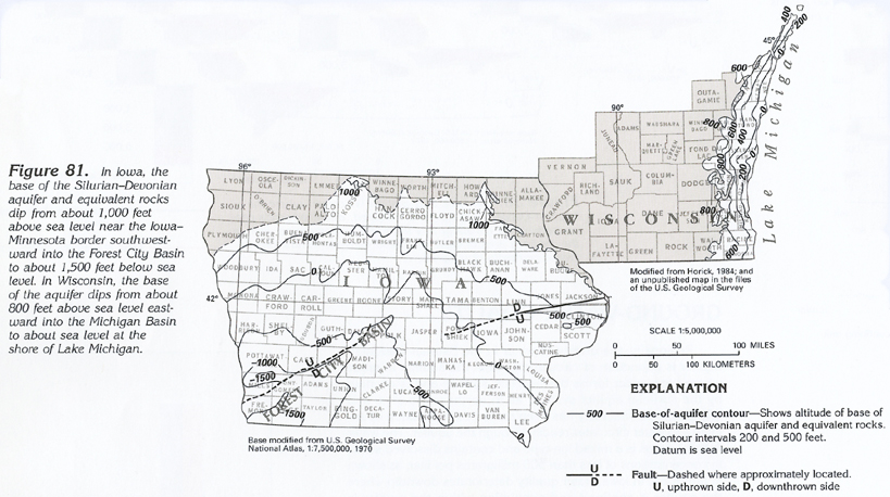
The Silurian-Devonian aquifer in Iowa dips southwestward (figs. 80, 81) into the Forest City Basin. The base of the aquifer slopes from an elevation of about 1,000 feet above sea level in northeastern Iowa to about 1,500 feet below sea level in southwestern Iowa.
The Silurian-Devonian aquifer crops out along the shoreline of Lake Michigan in eastern Wisconsin, the eastern Upper Peninsula of Michigan, and along the shoreline of Lake Erie in the extreme southeastern part of the Lower Peninsula of Michigan. The aquifer dips and thickens radially into the Michigan Basin; thicknesses range from 1 to 200 feet at the outcrop where the rocks characteristically form an escarpment. The aquifer is 400 to 500 feet thick at its downdip extent. In Wisconsin, the base of the aquifer slopes eastward from an altitude of about 800 feet above sea level along parts of its western margin to slightly below sea level along parts of the shore of Lake Michigan. In the Upper Peninsula of Michigan, the base of the aquifer is at an altitude of about 800 feet above sea level and slopes southward into the Michigan Basin.
The Silurian part of the aquifer crops out and subcrops beneath glacial drift in the southeastern part of the Upper Peninsula of Michigan and in a small area of the southeastern part of the Lower Peninsula (fig. 77). In the Upper Peninsula, the aquifer consists of carbonate rocks of the Niagara, the Salina, and the Bass Island Groups (fig. 76); the Niagara Group is an important aquifer in areas of outcrop and where overlain by drift. Generally, yields of water to wells 50 to 200 feet deep range up to 50 gallons per minute.
The lower part of the Silurian section in Michigan, especially a dolomite unit in the Cataract Group (fig. 76), is generally in hydraulic connection with the Ordovician Richmond Group carbonate rocks. These rocks comprise a water-bearing zone locally that is confined between a shale in the upper part of the Cataract Group and a shale in the Lower Ordovician Richmond Group. This zone crops out in the southeastern part of the Upper Peninsula. It contains water that is generally highly mineralized and usable only in the outcrop area where it is in hydraulic connection with the surficial aquifer system.
Rocks of the Bass Island Group crop out or subcrop beneath glacial drift in the extreme southeastern part of the Lower Peninsula of Michigan. Yields of water to wells sufficient for domestic purposes can be obtained in subcrop areas.
Devonian rocks in Michigan consist of limestone and dolomite with interbedded shale, chert, and anhydrite stringers. The Sylvania Sandstone, which is a fine- to medium-grained sandstone, occurs in the lower part of the Detroit River Group. This sandstone is an important water-bearing zone in the southeastern part of the Lower Peninsula and yields up to 50 gallons per minute to wells. The Devonian carbonate rocks have extensive karst development in their outcrop and subcrop areas of the northeastern part of the Lower Peninsula of Michigan and in the subcrop areas of the southeastern part of the Lower Peninsula.
Water movement in the Silurian-Devonian aquifer in Iowa and Wisconsin can be inferred from the potentiometric-surface map in figure 82. In Iowa, water moves regionally from the area of outcrop southeastward toward the Illinois Basin in south-central Illinois. Locally, water moves from upland areas of recharge along short flow paths to nearby rivers where ground-water discharge comprises a large part of the streamflow. Although information is not available on movement in the confined area of the aquifer, the water probably moves slowly south and southeastward to be discharged to major rivers in Iowa, Missouri, and Illinois.
Water movement in the Silurian-Devonian aquifer in Wisconsin (fig. 82) is regionally eastward toward Lake Michigan and the Michigan Basin. Locally, water moves along short flow paths toward streams where it is discharged. The aquifer is unconfined or only partially confined in Wisconsin.
Regional water movement in the Silurian-Devonian aquifer in Michigan is toward the center of the Michigan Basin. Local water movement is along short flow paths toward streams and the Straits of Mackinac where the water is discharged. Compared to where the aquifer is confined, movement is relatively rapid in the area where the aquifer forms the bedrock surface and is unconfined, especially where the permeability of the aquifer has been enhanced by the development of karst features.
POTENTIAL WELL YIELDS
Potential yields of wells with a depth of 100 to 300 feet completed
in the Silurian-Devonian aquifer in Iowa typically range from
100 to 500 gallons per minute in the area where the aquifer forms
the bedrock surface, but only range from 20 to 50 gallons per
minute in other areas. Well yields, therefore, are more dependant
on the degree of secondary porosity developed in the carbonate
rocks rather than on the thickness of the rocks.
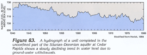
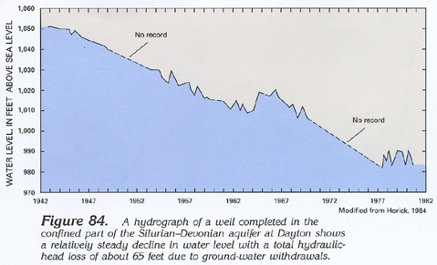
A hydrograph for a 282-foot-deep well in a well field at Cedar Rapids, Iowa, in the area where the aquifer forms the bedrock surface, shows a water-level decline of only about 20 feet after the well field had produced about 1.88 million gallons per day from 1940 through 1980 (fig. 83). The hydrograph fluctuations indicate that the aquifer is recharged from precipitation moving quickly through the overlying surficial aquifer system. Conversely, a hydrograph for a 1,240-foot-deep well in a well field at Dayton, Iowa, in the confined part of the aquifer, shows water-level declines of about 65 feet from 1942 through 1981 after the well field was pumped at a rate of only about 75,000 gallons per day (fig. 84).
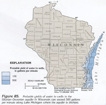
In Wisconsin, the Silurian-Devonian aquifer receives recharge directly from the overlying surficial aquifer system and commonly yields from 100 to about 500 gallons per minute to wells (fig. 85), depending on the thickness of the aquifer.
In the southeastern part of the Lower Peninsula of Michigan where the aquifer is unconfined, reported specific-capacity values ranged from 1 to 9 gallons per minute per foot of drawdown, and maximum well yields are as much as 50 gallons per minute. Throughout most of the Lower Peninsula where the aquifer is confined, it contains saltwater, and development of the aquifer for water supplies is minimal. In the southeastern part of the Upper Peninsula, data for ten 10- to 349-foot-deep wells completed in the aquifer indicate that the specific capacity ranged from 0.1 to 9 gallons per minute per foot of drawdown and that maximum well yields are about 100 gallons per minute.
GROUND-WATER QUALITY
Regionally, the quality of water in the Silurian-Devonian
aquifer is a function of circulation within the aquifer. In areas
where the aquifer forms the bedrock surface and is overlain by
the surficial aquifer system, as in northeastern Iowa and Wisconsin,
permeability has been enhanced by solution openings, and water
circulates readily through the aquifer. The water in these areas
is a mixed ion type and contains dissolved solids in concentrations
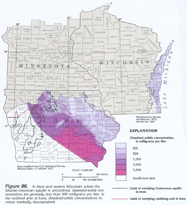
of less than 500 milligrams per liter, as shown in figure 86.
In Iowa, water quality deteriorates downdip where the aquifer
is confined and circulation within the aquifer is sluggish, and
recharge is primarily from downgradient movement. Dissolved-solids
concentrations in Iowa increase to about 5,000 milligrams per
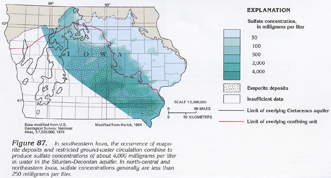
liter (fig. 86). Sulfate concentrations
(fig. 87) increase to thousands of
milligrams per liter in these downdip areas.
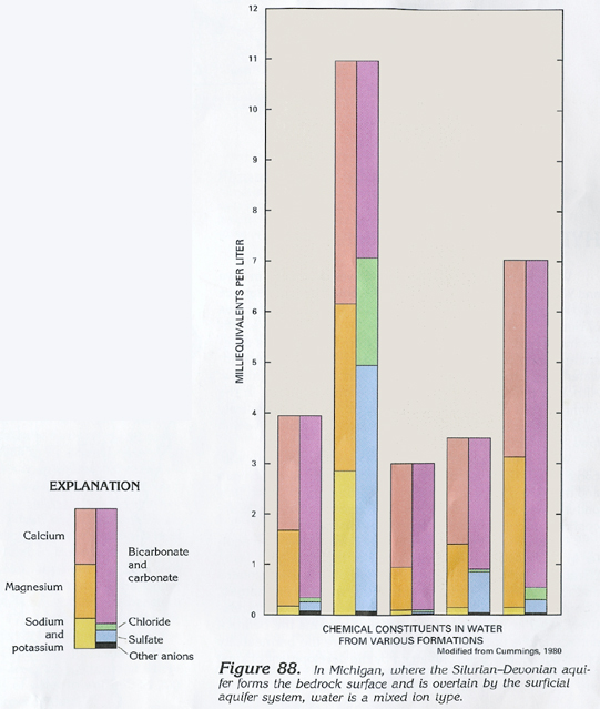
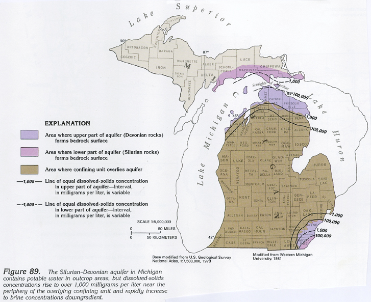
Similar conditions occur in Michigan. In the area where the Silurian-Devonian aquifer forms the bedrock surface and is overlain by the surficial aquifer system, the water is a mixed ion type (fig. 88) with dissolved-solids concentrations in the range of 200 to 500 milligrams per liter. Downdip, at, or near the contact of overlying rocks, dissolved-solids concentrations increase to 1,000 milligrams per liter, as shown in figure 89. A short distance farther downdip, the water is a brine; dissolved-solids concentrations in excess of 160,000 milligrams per liter have been reported in water from these rocks in the center of the Michigan Basin.
FRESH GROUND-WATER WITHDRAWALS
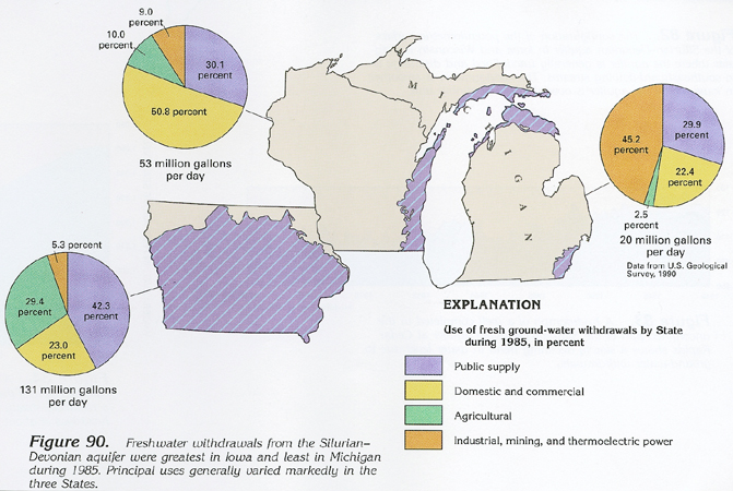
Fresh ground-water withdrawals from the Silurian-Devonian
aquifer in Iowa, Wisconsin, and Michigan totaled 204 million gallons
per day during 1985 (fig. 90). Public
supply and domestic and commercial uses accounted for 67 percent
of the total use in the three States, agricultural use (including
irrigation) accounted for 21 percent, and industrial, mining,
and thermoelectric-power uses accounted for 12 percent.