INTERIOR LOW PLATEAUS AQUIFERS
INTRODUCTION
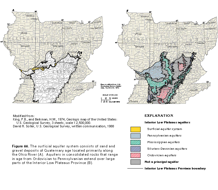
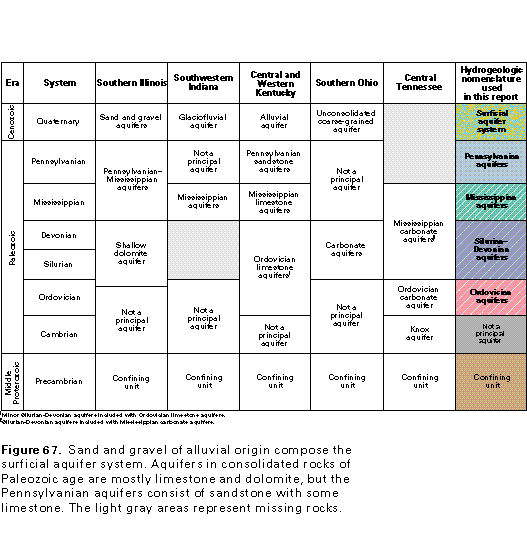
The Interior Low Plateaus aquifers in Segment 10 consist of the same two general categories of rocks as those in the Central Lowland Province-unconsolidated sand and gravel deposits of Quaternary age that compose the surficial aquifer system and consolidated limestone, dolomite, and sandstone of Paleozoic age (figs. 66 and 67). The surficial aquifer system is present only along the Ohio River Valley and a few of its tributaries in the northern part of the Interior Low Plateaus Province (fig. 66A), in contrast with the large areal extent of the aquifer system in the Central Lowland Province. The principal aquifers in Paleozoic rocks are sandstone and limestone aquifers in rocks of Pennsylvanian age, limestone aquifers in rocks of Mississippian age, and limestone and dolomite aquifers in rocks of Devonian, Silurian, and Ordovician age (figs. 66B and 67).
The major hydrogeologic difference between the Interior Low Plateaus and the Central Lowland Provinces is the restricted distribution of the Quaternary deposits of the surficial aquifer system and the consequent exposure of the Paleozoic rocks throughout most of the Interior Low Plateaus. As a result, recharge to and discharge from the aquifers in rocks of Paleozoic age take place directly in the Interior Low Plateaus Province, whereas they take place mostly through the Quaternary deposits in the Central Lowland Province. Precipitation is the primary source of recharge in the Interior Low Plateaus Province. Most of the precipitation becomes overland runoff to streams, but some percolates downward through soil and residuum to the underlying bedrock. Some water is stored in and moves through intergranular pore spaces in the soil, residuum, and unconsolidated deposits of Quaternary age. In the consolidated rocks, however, most of the water moves through and is discharged from secondary openings, such as joints, fractures, bedding planes, and solution openings. As a result, ground-water discharge from springs is common throughout the Interior Low Plateaus Province in Segment 10.
SURFICIAL AQUIFER SYSTEM
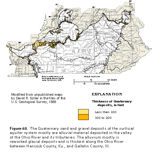
The sand and gravel deposits of Quaternary age along the Ohio River compose the principal aquifers in unconsolidated rocks in the Interior Low Plateaus Province in Segment 10. These aquifers, which are collectively called the surficial aquifer system, consist primarily of alluvium reworked from the Quaternary glacial sand and gravel deposits of the surficial aquifer system in the Central Lowland Province to the north.
The distribution and approximate thickness of the Quaternary deposits in the Interior Low Plateaus Province are shown in figure 68. Typically, the lower two-thirds or more of the alluvial deposits consists of coarse sand and gravel that directly overlie bedrock. These coarse-grained sediments form the principal aquifers in unconsolidated rocks. The upper part of the alluvial deposits consists of fine sand, silt, and clay. All or part of these fine-grained sediments may be unsaturated.
The saturated thickness of the Quaternary deposits increases from east to west along the Ohio River. In Kentucky, the saturated thickness is about 35 feet in Lewis County, about 80 feet around Louisville in Jefferson County, and about 110 feet in Henderson County. If all other factors remain the same, then the amount of water an aquifer will yield increases in direct proportion to the saturated thickness of the aquifer.
Aquifer Characteristics and Well Yields
Aquifer-test data from Kentucky indicate that median values of transmissivity for different areas of the surficial aquifer system along the Ohio River range from about 4,400 to 28,000 feet squared per day. The greater the transmissivity, the more readily water can move through the aquifer system. The median specific capacities reported for 173 wells completed in different areas of the surficial aquifer system along the Ohio River in Kentucky range from about 14 to 110 gallons per minute per foot of water-level drawdown. These data indicate that large yields can be expected from wells completed in the sand and gravel aquifers, particularly where the saturated deposits are coarse grained and thick. It is common for wells near the Ohio River to have sustained yields of 1,000 gallons per minute if they are completed in coarse-grained, well-sorted, thick alluvial deposits that are hydraulically connected to the river.
Ground-Water Quality
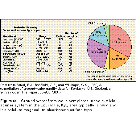
Chemical analyses of water from selected wells completed in the surficial aquifer system in the Louisville, Ky., area are shown in figure 69. These data are examples of the chemical characteristics of water from the sand and gravel aquifers in the Interior Low Plateaus Province.
The water typically is hard and is a calcium magnesium bicarbonate sulfate type (fig. 69) with large concentrations of iron. Large dissolved-solids concentrations (exceeding 500 milligrams per liter) and large iron concentrations (exceeding 0.3 milligram per liter) are common problems. Dissolved-solids concentrations in water from wells in the Louisville area range from about 220 to about 2,360 milligrams per liter with a median of 960 milligrams per liter.
The distance of wells from rivers and streams and the type of underlying bedrock affect the chemical characteristics of the water from wells completed in the surficial aquifer system. Concentrations of dissolved solids, hardness-causing constituents (calcium and magnesium in particular), and, in some cases, sulfate are likely to be larger in water from wells in areas underlain by limestone and smaller in water from wells near rivers and streams. The larger concentrations of these constituents might result from mixing of the water in the surficial aquifer system with more highly mineralized water that is discharged from the underlying limestone into the sand and gravel aquifers. The smaller concentrations might result from the mixing of ground water with less mineralized river water that recharges the aquifer system near pumping wells.
Fresh Ground-Water Withdrawals
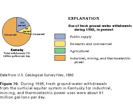
During 1985, about 113 million gallons per day was withdrawn from wells completed in the surficial aquifer system in the Interior Low Plateaus Province in Segment 10. Most of the withdrawals were along the Ohio River in Kentucky. The 113 million gallons withdrawn from this aquifer is about 55 percent of the total fresh ground water withdrawn in Kentucky during 1985. Almost three-fourths of the water withdrawn from the surficial aquifer system during 1985 was used for industrial, mining, and thermoelectric power purposes (fig. 70). Withdrawals for public supply were the second largest use category.
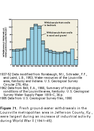
The history of withdrawals in the Louisville area in Jef-ferson County, Ky., is an example of how the need for ground water can change through time (fig. 71). From 1937 to 1940, fresh ground-water withdrawals were about 40 million gallons per day in the Louisville metropolitan area. The use of ground water rose sharply until withdrawals were about 100 million gallons per day during 1943 and 1944 because of increased industrial activity during World War II. After the war, withdrawals declined to the point that only about 15 million gallons per day was withdrawn in Jefferson County during 1985; the total withdrawal that year was less than one-half the average annual withdrawals from 1946 to 1952.
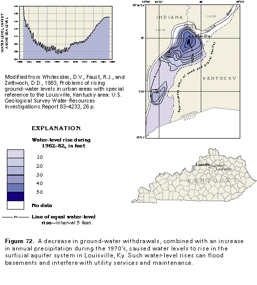
Water levels in the surficial aquifer system in the Louisville area have risen in response to the decrease in ground-water withdrawals. The hydrograph shown in figure 72 illustrates the decline and rise of the water level in a well in northeastern Louisville from 1937 to 1983. The water level began to rise in 1962 and continued to rise until 1980. The rise was more than 50 feet in a small part of downtown Louisville, as shown by the map in figure 72, and caused some problems in the area. Perhaps the most severe problems were the weakening of basements because of water leaks and local damage to underground gas, electric, water, and sewer lines.
PENNSYLVANIAN AQUIFERS
Hydrogeologic Setting
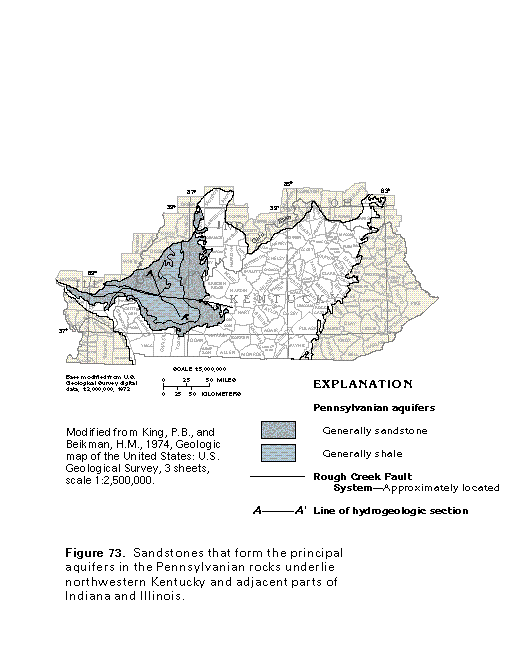
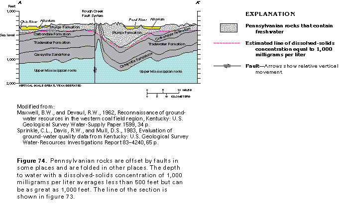
Sandstones of Pennsylvanian age are the principal aquifers in consolidated rocks throughout most of the northwestern part of the Interior Low Plateaus Province in Segment 10. These sandstones are present in the northwestern part of Kentucky (known as the Western Coal Field), southwestern Indiana, and part of the southern tip of Illinois (fig. 73). Where present, these sandstones are used as a source of water except where they are overlain by Quaternary sand and gravel aquifers of the surficial aquifer system in the valleys of the Ohio River and its tributaries.
The Pennsylvanian rocks are folded into a syncline (fig. 74) that plunges to the north and northwest into the Illinois Basin. Sandstones of the Caseyville and the Tradewater Formations are at land surface on the periphery of the area as shown in figure 73 and dip beneath younger Pennsylvanian rocks in the central part of the area. The rocks are offset by several nearly vertical faults that trend east to west and might act as conduits for or barriers to ground-water movement.
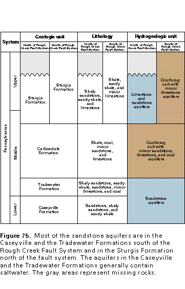
The Pennsylvanian sandstones, like those in the Central Lowland Province, are part of repeating sequences of coal-bearing rocks deposited during sedimentary cycles. An ideal complete cycle consists of the following sequence of beds, listed from bottom to top: basal sandstone, sandy shale, limestone, underclay, coal, gray shale, limestone, black platy shale, limestone, and silty gray shale with iron concretions. Most of the sandstones are in the upper and lower parts of the Pennsylvanian rocks (fig. 75). The sandstones mostly are channel-fill deposits and are separated by sequences of shale, coal, and limestone. Sandstones are more common north of the Rough Creek Fault System than south of it, and shale, sandy shale, and limestone are more common south of the fault system than to the north.
Part of the precipitation that falls on the exposed Pennsylvanian rocks percolates downward to the water table to recharge the aquifers in these rocks. The water then moves through the aquifers from areas of higher hydraulic head (high water levels), such as uplands and interstream areas, to discharge at areas of lower hydraulic head (low water levels), such as streams and springs. The water primarily moves through fractures and bedding planes in the rocks. The general direction of regional ground-water movement is toward the Ohio River and its tributaries. Most of the ground water moves along short flow paths through the shallow parts of the zone of saturation to discharge at nearby streams. Some water discharges to springs and wells.
In most places, the freshwater-saltwater interface in the Pennsylvanian aquifer is at depths of less than 500 feet below land surface. The deepest occurrence of freshwater in these aquifers is in Hopkins and Muhlenberg Counties, Ky. Here, freshwater is present more than 400 feet below sea level, or more than 1,000 feet below land surface. The origin of this deep freshwater is unknown.
Aquifer Characteristics and Well Yields
Limited data from wells completed in the Pennsylvanian aquifers in Kentucky indicate well yields range from 0.5 to 150 gallons per minute and average about 25 gallons per minute. The median well yield is 9 gallons per minute.
Large water-level declines might result from small to moderate ground-water withdrawals in some of the Pennsylvanian aquifers. Such declines are most probable in aquifers that have low permeability, small areal extent, and limited recharge. Water levels in the sandstone aquifers that lie at depths of greater than 500 feet below land surface and that are completely surrounded by rocks of low permeability are the most likely to show large declines. Typically, large water-level declines are accompanied by high costs of the energy used to pump the water.
Ground-Water Quality
Sparse data indicate that the aquifers in Upper Pennsylvanian rocks contain hard water that is a calcium magnesium bicarbonate type. The calcium and magnesium in the water probably are derived from the partial dissolution of limestone beds or carbonate cements in sandstone beds.
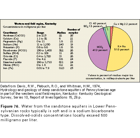
The quality of the ground water from the sandstone aquifer in Lower Pennsylvanian rocks in the Interior Low Plateaus generally is suitable for most uses. The water typically is soft and is a sodium bicarbonate type (fig. 76). In places, the water contains concentrations of iron that exceed 0.3 milligram per liter. Water from wells deeper than 500 feet might contain concentrations of chloride that exceed 250 milligrams per liter. In places, dissolved-solids concentrations exceed 500 milligrams per liter. Saltwater locally is present in the Pennsylvanian aquifers at depths as shallow as 100 feet. The shallow saltwater usually is beneath the valleys of major streams.
Fresh Ground-Water Withdrawals
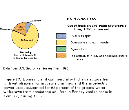
Only small quantities of freshwater are withdrawn from the sandstone aquifers in Pennsylvanian rocks in the Interior Low Plateaus Province in Segment 10. Total withdrawals during 1985 were estimated to be about 10 million gallons per day, of which about 6 million gallons per day was withdrawn in Kentucky and about 2 million gallons per day was withdrawn in each of Illinois and Indiana. During 1985, 74 percent of the water withdrawn from these aquifers in Kentucky was used for domestic and commercial purposes, and 18 percent was withdrawn for industrial, mining, and thermoelectric power uses (fig. 77). Practically all the remaining withdrawals were for public supply.
MISSISSIPPIAN AQUIFERS
Hydrogeologic Setting
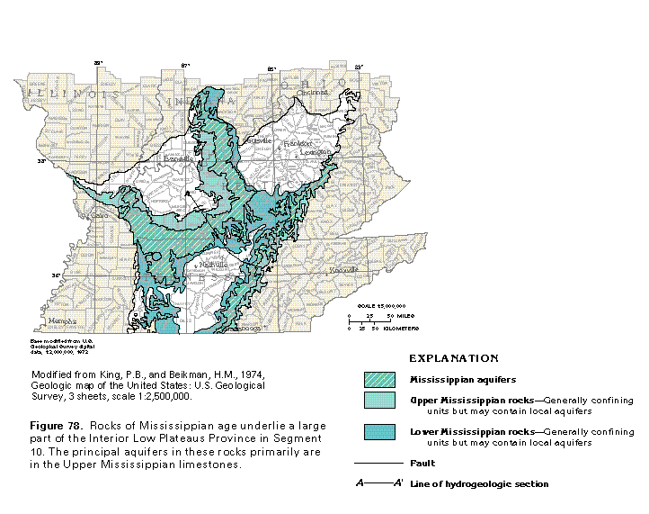
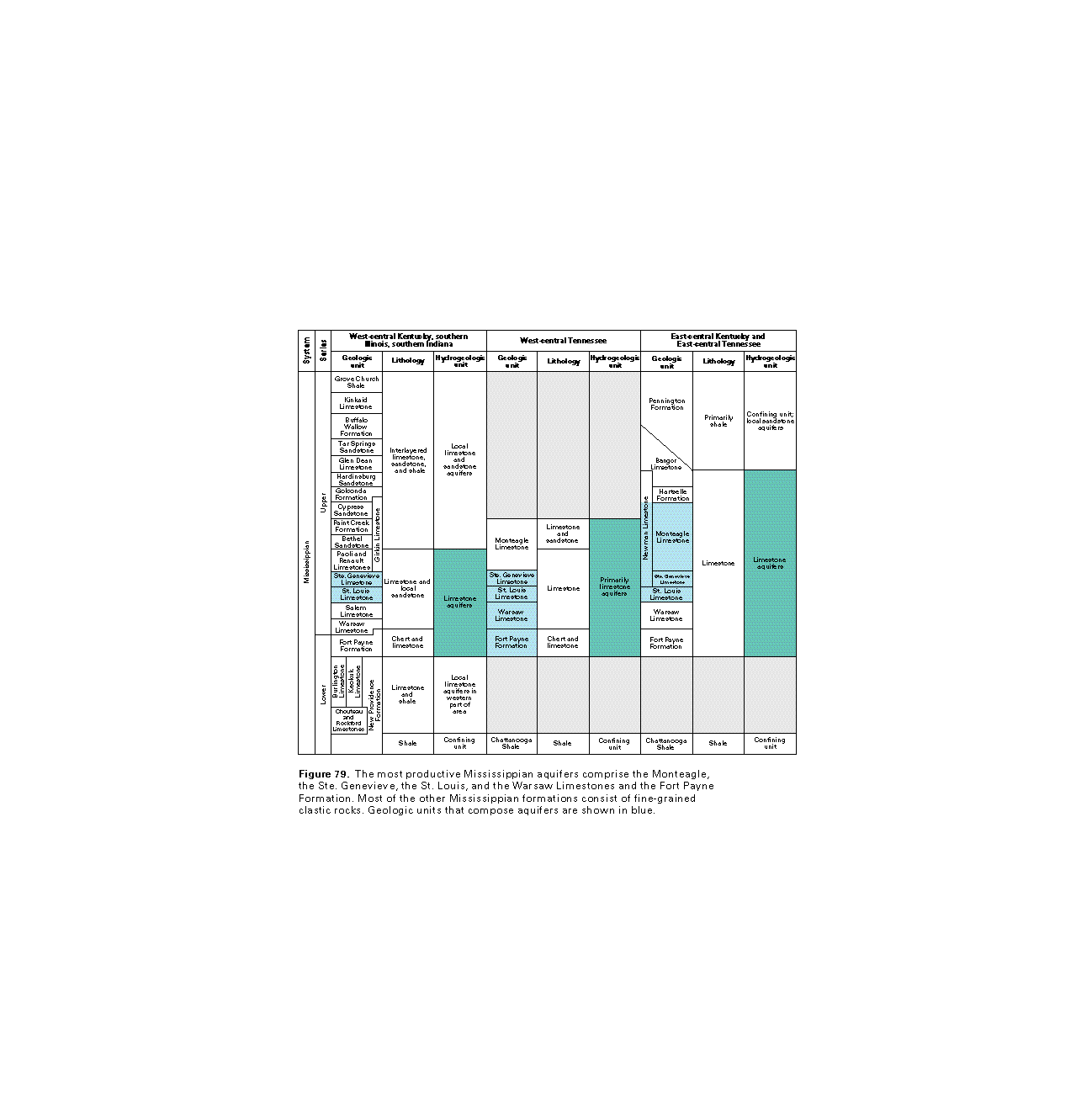
A large part of the Interior Low Plateaus Province in Segment 10 is underlain by limestone aquifers in Mississippian rocks (fig. 78). These aquifers have been called the Mississippian Plateau aquifers in Kentucky and the Highland Rim aquifer system in Tennessee. They are present in limestone that is either flat lying or gently dipping and are capped by a layer of regolith that varies greatly in thickness. In general, the limestone aquifers that yield the largest quantities of water to wells and springs are the Upper Mississippian Monteagle, the Ste. Genevieve, and the St. Louis Limestones (fig. 79). Where the Monteagle, the Ste. Genevieve, and the St. Louis are thin or missing, such as in the southwestern part of central Tennessee, the Warsaw Limestone along with chert and limestone beds of the Fort Payne Formation are the principal aquifers.
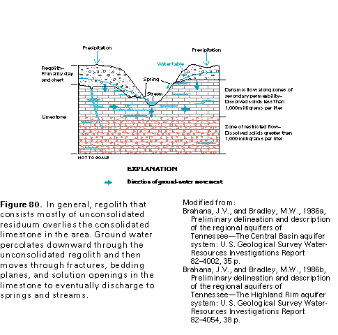
In most places, the Mississippian aquifers are covered by regolith, which mostly consists of weathered material, or residuum (fig. 80). This material consists of clay, silt, sand, and pebble-sized particles of limestone or chert, which are derived mostly from weathering of the underlying bedrock. In the southwestern part of central Tennessee, the regolith might consist mostly of chert left from the weathering of the Fort Payne Formation. Where thick and saturated, this chert rubble constitutes a productive local aquifer. The regolith can store large quantities of water that subsequently percolate slowly downward to recharge aquifers in the underlying consolidated rock. The regolith is as thick as 150 feet in several places in the Interior Low Plateaus Province in Tennessee.
The conceptual flow system in the Mississippian aquifers is shown in figure 80. Precipitation infiltrates the land surface and percolates downward to the water table, which marks the top of the zone of saturation. The water moves through intergranular spaces in the unconsolidated material of the regolith. However, in the underlying limestone bedrock, the water moves through zones of secondary permeability created by dissolution enlargement of bedding planes and fractures by the slightly acidic water. The solution openings store and transmit most of the water that moves through the limestone and discharges to streams, springs, and wells. Little water passes through the blocks of limestone between the bedding planes and fractures.
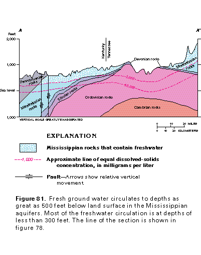
Freshwater circulates through the limestone aquifers to depths as great as 500 feet below land surface (fig. 81). However, most of the circulation is at depths of less than 300 feet. All other factors being equal, the freshwater circulation is deepest where the local topographic relief and attendant hydraulic gradients are greatest. For example, the depth to water with 10,000 milligrams per liter dissolved solids in the Mississippian aquifers is greatest near the escarpment between the Appalachian Plateaus and the Interior Low Plateaus Provinces near the right end of the section shown in figure 81.
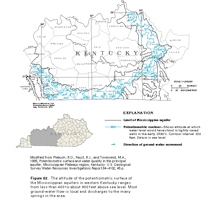
The altitude and configuration of the potentiometric surface and the general direction of ground-water movement in the Mississippian aquifers (the Ste. Genevieve and the St. Louis Limestones) in western Kentucky are shown in figure 82. The altitude of the potentiometric surface ranges from less than 400 feet above sea level in the west to more than 900 feet above sea level in three small areas in the east. However, little, if any, regional ground-water flow occurs. Most of the flow is local, toward springs and the few streams that drain the area. An escarpment that bounds the aquifer on the north is aptly named the "Dripping Springs Escarpment" because of the many small seeps and springs that discharge water along it.
Water in the Mississippian aquifers generally moves in a direction perpendicular to the potentiometric contours, as shown by the arrows in figure 82. However, the water locally moves along fractures and bedding planes that might be nearly perpendicular to one another. Consequently, the arrows that show ground-water flow direction indicate only the general direction of water movement in a complex flow system that has many local horizontal and vertical components.
Effects of Dissolution
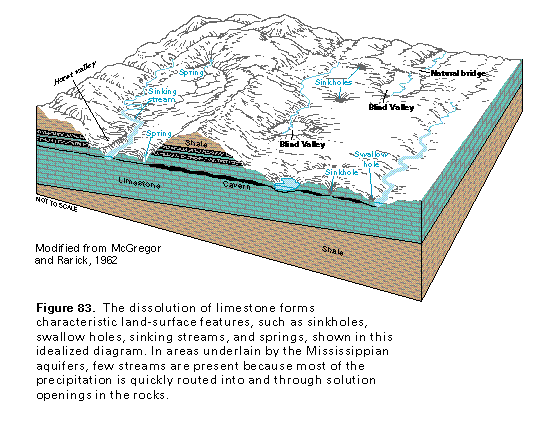
An idealized diagram of some of the common types of features that develop on the land surface where Mississippian limestones are exposed and are partially dissolved by circulating, slightly acidic ground water is shown in figure 83. Recharge water enters the limestone aquifers through sinkholes, swallow holes, and sinking streams. Stream density, as measured by the total length of perennial streams in a square mile, is low in areas underlain by the limestone; this indicates that most of the surface runoff is quickly routed underground through solution openings in the rocks. In the subsurface, most of the water moves through caverns and other types of large solution openings.
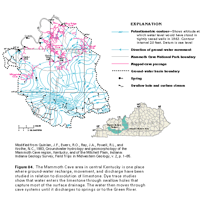
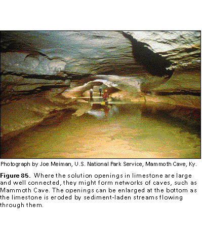
An excellent example of the extent and interconnection of large solution cavities that form as a result of the dissolution of limestone by circulating freshwater is the Mammoth Cave area in Kentucky (fig. 84). The Mississippian limestones that underlie the Mammoth Cave Plateau are riddled with sinkholes and solution cavities that have developed along bedding planes and joints. Some of these solution openings form the large caves that have fascinated visitors and area residents since pioneer times (fig. 85). As the network of caves develops, surface streams might be diverted into sinkholes and flow through the larger solution openings as underground streams. Sand and other sediment carried by the underground streams abrade the limestone; this further enlarges the opening through which the stream flows.
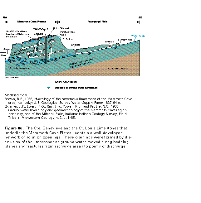
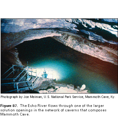
The solution openings in the limestone are so well developed in the Mammoth Cave area that most surface runoff enters the rocks through sinkholes and moves through solution cavities to springs (fig. 86). Accordingly, surface streams in the area are few. Most of the water moves rapidly downward through enlarged, well-connected solution openings to the main water table and then moves laterally to discharge from springs into the Green River. Some of the solution openings are large enough to contain underground streams, such as Echo River (fig. 87). However, some of the water moves more slowly through openings that are small and poorly interconnected; for example, small quantities of water move slowly through intergranular spaces and small fractures in the Big Clifty Sandstone Member of the Golconda Formation. Larger quantities of water move more rapidly through small openings in some parts of the limestone of the underlying Girkin Formation, and very large quantities of water move rapidly through a large network of solution openings in the Ste. Genevieve and the St. Louis Limestones (fig. 86). Discontinuous layers of shale in the Girkin Formation impede the downward movement of water where the shales are present and help support perched water bodies. The top of the perched water bodies might be 300 feet or more above the main water table.
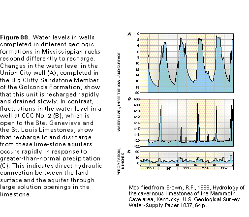
The presence or absence of solution openings affects aquifer recharge and discharge in the Mammoth Cave area and is reflected by the water levels in wells completed in different aquifers. The Union City well (fig. 88A) is completed in the Big Clifty Sandstone Member of the Golconda Formation (fig. 86), which is a rock unit with few large openings. The water levels in this well show that recharge to the Big Clifty is rapid and mostly takes place from late winter to early spring. Some of the water discharges to springs, but most drains gradually into deeper aquifers during the rest of the year. When the hydraulic head (water level) in the Big Clifty is high, the water drains rapidly into the rocks below, but as the water level continues to decline, the water drains more and more slowly. In contrast, the well at CCC No. 2 (fig. 88B) is open to the Ste. Genevieve and the St. Louis Limestones (fig. 86), which are characterized by an abundance of well-connected solution openings. The water level in these rocks can fluctuate rapidly depending on antecedent conditions, the season of the year, and local precipitation. The water level in the well at CCC No. 2 showed almost no change during dry weather and after light summer rains; however, following periods of greater-than-normal precipitation (fig. 88C), the water level rose sharply. This water-level response indicates that the well at CCC No. 2 is open to solution openings in the limestone. These openings allow rapid recharge to and equally rapid discharge from the aquifer during and immediately following periods of intense precipitation.
Aquifer Characteristics, Yields of Wells, and Discharges of Springs
The hydraulic characteristics of the Mississippian aquifers vary greatly over short distances. For example, the ability of limestone with large, interconnected solution openings to transmit and yield water is several orders of magnitude greater than that of the almost impermeable blocks of limestone between solution openings, fractures, and bedding planes. These large differences are reflected in the yield and specific capacity of wells completed in the limestone aquifers and the discharges of springs that issue from these aquifers.
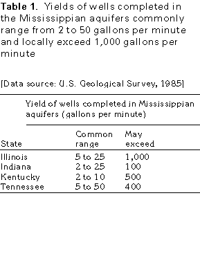
The data in table 1 indicate that the yields of wells completed in the Mississippian aquifers vary greatly. Well yields commonly range from 2 to 50 gallons per minute, and reported maximum yields range from about 100 gallons per minute in Indiana to 1,000 gallons per minute in Illinois. Wells that penetrate large, saturated solution openings may yield several thousands of gallons per minute. However, such openings constitute only a small part of the rock and might be difficult to locate.
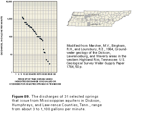
The discharges of 31 selected springs that issue from Mississippian aquifers in the western part of the Interior Low Plateaus Province in Tennessee range from about 3 to 1,100 gallons per minute, with a median discharge of about 200 gallons per minute (fig. 89). These springs issue mainly from the Warsaw Limestone and the Fort Payne Formation, and those that discharge several hundred gallons per minute or more are equally distributed between the Warsaw and the Fort Payne. These data indicate that discharge can vary from spring to spring.
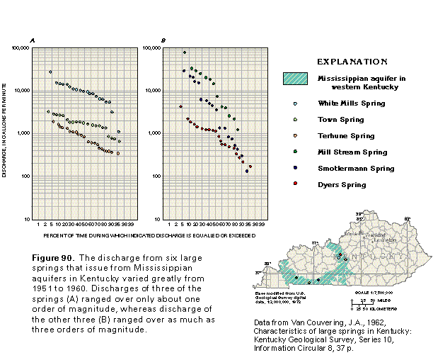
The distribution of discharges for six large springs in Kentucky is shown in figure 90. These springs issue primarily from the St. Louis Limestone. These discharges, which were measured from 1951 to 1960, indicate the variability from spring to spring and through time at a given spring. The difference between the high and low discharges measured at a spring varies by a factor of about 5 to about 200. Knowledge of such discharge variability is important when planning the use of springs for water supply. Discharges of the springs shown in figure 90B are more variable than those of the springs shown in figure 90A.
Ground-Water Quality
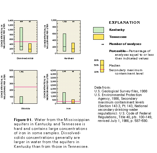
The quality of water in the Mississippian aquifers in Kentucky is somewhat different from that in Tennessee (fig. 91). The range of concentrations and the median concentration of dissolved solids, iron, and the median hardness are greater for water from these aquifers in Kentucky than in Tennessee. However, median concentrations of dissolved solids and iron in both States are less than the secondary maximum contaminant levels for drinking water established by the U.S. Environmental Protection Agency. The quality of the water generally is adequate, or it can be treated and made adequate for most uses.
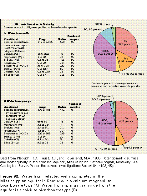
Water-quality data from wells and springs in the Mississippian aquifers in Kentucky indicate that the water is either a calcium magnesium bicarbonate type or a calcium bicarbonate type. The water type changes slightly as the proportion of magnesium and sulfate vary. Chemical analyses of water from wells and springs in the St. Louis Limestone were selected to represent the quality of water in the Mississippian aquifers in Kentucky (fig. 92). Water from wells (fig. 92A) has a larger proportion of magnesium and sulfate and a slightly larger proportion of chloride than that from springs (fig. 92B). Sparse data from wells and springs in Tennessee indicate that the quality of the water in the Mississippian aquifers is similar to that of Mississippian aquifer spring water in Kentucky.
Water with the large concentrations of sulfate is from wells that penetrate anhydrite and gypsum beds in the deeper parts of the Mississippian aquifers in Kentucky. The water moves slowly and follows long flow paths in the deep parts of the aquifers; therefore, the water is in contact with the aquifer minerals for a long time and dissolves much mineral material. In contrast, water that discharges from springs and water from wells that penetrate only shallow parts of the aquifers have smaller concentrations of dissolved solids because the water has moved only short distances or has had limited residence time in the aquifers and thus has had little opportunity to dissolve minerals.
Contaminated and turbid water are problems that can plague the users of water from wells and springs in limestone aquifers. Sinkholes are sometimes used to dispose of solid and liquid wastes. Water that recharges limestone aquifers through waste-filled sinkholes can transport contaminants into the aquifer, and the contaminated water can spread rapidly through a system of interconnected solution openings until it reaches wells or springs. Solution features, such as swallow holes, in streambeds allow sediment-laden storm runoff to enter the aquifers directly. Turbid water also can be caused by pumping of large-capacity wells, which results in the rapid movement of water through solution openings lined with silt or clay. Contamination and turbidity problems can become worse during periods of prolonged, intense rainfall.
Fresh Ground-Water Withdrawals
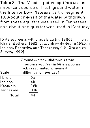
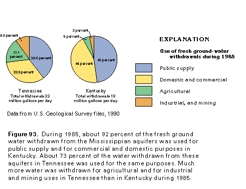
Total fresh ground-water withdrawals during 1985 from the Mississippian aquifers in the Interior Low Plateaus part of Segment 10 were about 64 million gallons per day (table 2). No 1985 withdrawal data were available for the Mississippian aquifers in Illinois; therefore, 1980 withdrawals were used for tabulation. About 80 percent of the total withdrawals were in Tennessee and Kentucky where the Mississippian aquifers are most areally extensive. Ground-water withdrawals in Tennessee and Kentucky were primarily for public supply and domestic and commercial uses (fig. 93). These use categories accounted for about 73 percent of the total withdrawals in Tennessee and about 92 percent in Kentucky during 1985. The remaining withdrawals were for agricultural and industrial and mining purposes. No water was withdrawn from the Mississippian aquifers in Tennessee and Kentucky for thermoelectric power use during 1985.
DEVONIAN, SILURIAN, AND ORDOVICIAN AQUIFERS
Hydrogeologic Setting
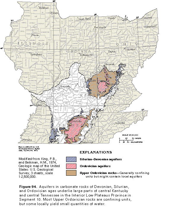
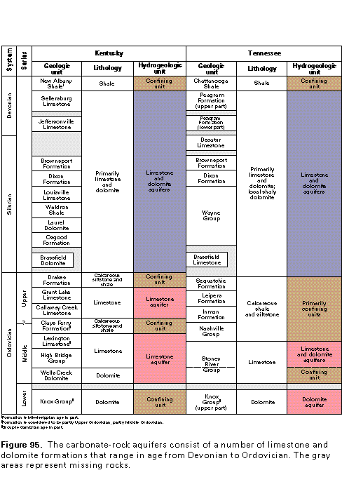
Carbonate rocks of Devonian, Silurian, and Ordovician age, which are primarily limestone with some dolomite, are the principal aquifers in large areas of central Kentucky and central Tennessee in the Interior Low Plateaus Province in Segment 10 (fig. 94). The Ordovician rocks crop out in the central part of these areas and lie beneath Silurian, Devonian, and younger rocks on the perimeter of the areas. The carbonate-rock aquifers consist of almost pure limestone and minor dolomite and are interlayered with confining units of shale and shaly limestone. Where these aquifers are in the subsurface, they are overlain by and separated from the Mississippian aquifers by a confining unit of Upper Devonian shale.
The majority of the carbonate-rock aquifers are in Ordovician rocks. The Middle Ordovician High Bridge and Stones River Groups and the Lexington Limestone and equivalent rocks are the most important carbonate-rock aquifers (fig. 95). Locally, the Upper Ordovician Grant Lake and the Callaway Creek Limestones and calcareous siltstone of the Middle Ordovician Nashville Group yield small volumes of water, but these units are not considered to be principal aquifers. The Lower Ordovician part of the Knox Group in Kentucky is not a principal aquifer because it either contains saltwater or is deeply buried and yields little freshwater. However, where dolomite of the Knox Group in Tennessee contains freshwater, the Knox is a principal aquifer. The Silurian Brassfield Dolo-mite/Limestone, the Wayne Group and equivalent rocks, and the Decatur Limestone are the most productive aquifers in Silu-rian rocks, and the Peagram Formation and its equivalents com-pose the aquifers in Devonian rocks. These geologic formations, excluding the Knox Group, have been referred to as the "Central Basin aquifer system" in Tennessee and the "aquifers of the Blue Grass region" in Kentucky.
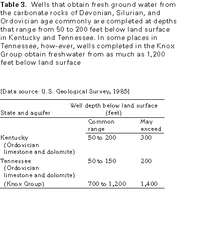
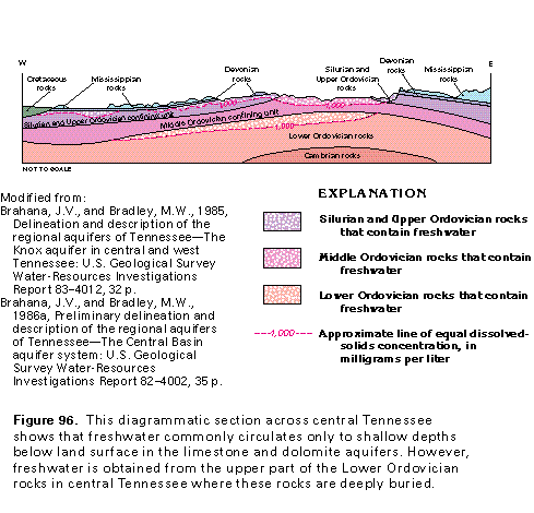
The depth of freshwater in the limestone and dolomite aquifers can vary greatly, but wells completed in these aquifers generally range from 50 to 200 feet deep in Kentucky and Tennessee (table 3). The depth to saltwater generally is greatest in areas where the limestone and dolomite aquifers crop out and least where they are covered with younger rocks that impede deep circulation of ground water. In a large area in central Tennessee, the upper parts of these aquifers are beneath a thin layer of Mississippian limestone or the Chattanooga Shale of Mississippian and Devonian age or both (fig. 96) and contain freshwater. The upper part of Lower Ordovician rocks in central Tennessee (the Knox Group) also contains freshwater but is separated from the shallower aquifers by a Middle Ordovician confining unit that contains more highly mineralized water. The Knox Group in this area apparently is recharged through fractures that transect the confining unit. The freshwater-saltwater interface in the Knox Group does not coincide with that in the shallower aquifers.
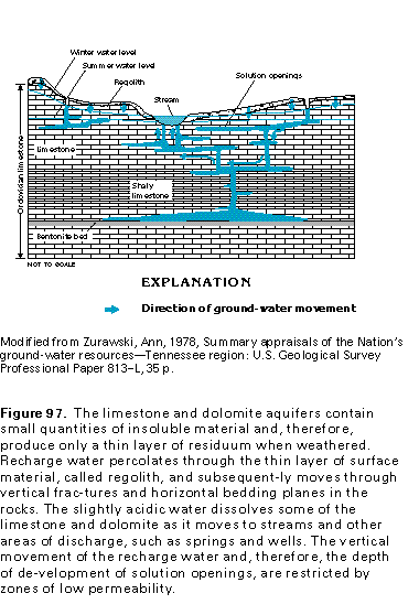
The occurrence and movement of ground water in the limestone and dolomite aquifers in Devonian, Silurian, and Ordovician rocks are much like those in the Mississippian aquifers. However, because the Devonian, Silurian, and Ordovician rocks generally contain small quantities of insoluble material, the aquifers in these rocks generally are covered in outcrop areas by a much thinner layer of regolith than are the Mississippian aquifers. The slightly acidic precipitation that falls on aquifer outcrop areas infiltrates the land surface and percolates downward to the water table. In the subsurface, the slightly acidic water forms solution openings as it moves along fractures and bedding planes and dissolves part of the limestone and dolomite of the Devonian, Silurian, and Ordovician rocks. Dissolution is less advanced in these aquifers, and caves are fewer than in the Mississippian aquifers. Ground water in the limestone and dolomite aquifers is almost exclusively stored in and moves through solution openings (fig. 97). Insignificant quantities of ground water are stored in and move through the almost impermeable blocks of limestone between the solution openings, bedding planes, and fractures. The distribution of solution openings is complex and difficult to map, but most openings are in the zone of dynamic freshwater circulation between land surface and depths from 200 to 400 feet below land surface. The volume of solution openings in the Ordovician limestones is estimated to be less than 0.5 percent of the total rock volume.
Confining units, such as beds of shaly limestone and bentonite, affect the depth to which freshwater circulates (fig. 97). Thin bentonite zones, which consist of clay particles that expand or swell when they become wet, form layers of low permeability that effectively impede the vertical movement of ground water. For example, in areas where the bentonite layers are continuous, the downward movement of ground water is restricted. This restriction isolates the ground water below the bentonite from the zone of dynamic circulation above the bentonite. In areas where the bentonite zones are breached by vertical fractures or have been eroded by stream valleys, ground water below the bentonite is more readily recharged or discharged and is part of the zone of dynamic freshwater circulation. In such places, solution-enlarged openings will develop beneath the bentonite.
Ground water in the limestone and dolomite aquifers moves from upland recharge areas where water-level altitudes are high to low-lying discharge areas where they are low. Most of the discharge areas are located along streams. In Kentucky, the streams that receive discharge from the carbonate-rock aquifers generally drain to the north and northwest into the Ohio River. Areas underlain by the freshwater-yielding limestone and dolomite aquifers in Tennessee are drained by the Cumberland and the Tennessee Rivers.
Yield of Wells and Discharges of Springs
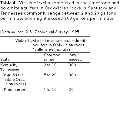
The yields of wells completed in the limestone and dolomite aquifers in rocks of Devonian, Silurian, and Ordovician age vary considerably throughout the area. This variability is caused primarily by large variations in hydraulic properties over short distances in the aquifers. The yields of wells completed in the carbonate-rock aquifers in Kentucky and Tennessee commonly range from 2 to 20 gallons per minute and can exceed 300 gallons per minute (table 4). Yields reported from 8,000 wells, drilled primarily to supply water for households and completed in limestone aquifers in Ordovician rocks in Tennessee, indicate that more than 90 percent of the wells obtained a supply of ground water adequate for domestic use; 70 percent had yields of more than 3 gallons per minute, 8 percent had yields of more than 25 gallons per minute, and slightly less than 1 percent had yields of 50 gallons per minute or more. The maximum well yield was 600 gallons per minute. About 90 percent of the wells that had yields of more than 25 gallons per minute were located in flat-bottomed valleys underlain by depressions in the carbonate bedrock.
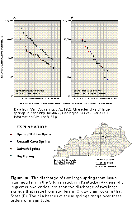
Spring discharge also is extremely variable. Discharges reported for 89 springs that issue from aquifers in the Silurian and Ordovician rocks in the south-central part of Tennessee range over more than four orders of magnitude (from 0.1 to about 2,500 gallons per minute) with a median discharge of about 6 gallons per minute. From 1951 to 1960, the reported discharge of four large springs that issue from these aquifers in Kentucky ranged over more than three orders of magnitude (fig. 98). Two of the springs issue from aquifers in Silurian rocks (fig. 98A) and had discharges that ranged from 300 to 40,000 gallons per minute. The other two springs issue from aquifers in Ordovician rocks (fig. 98B) and had discharges that ranged from 75 to 9,500 gallons per minute. These data indicate that discharge can vary greatly at a spring from season to season and from year to year.
Ground-Water Quality
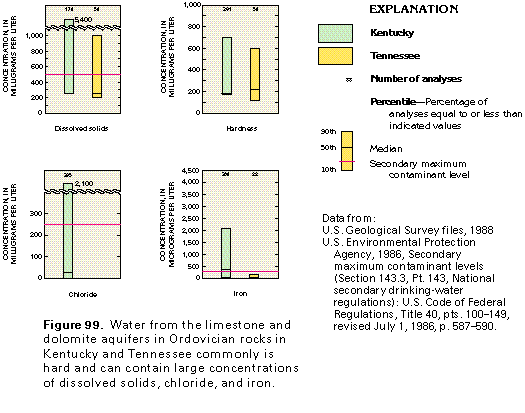
The quality of the water in the limestone and dolomite aquifers in Ordovician rocks in Kentucky and Tennessee is shown in figure 99; sparse data indicate that the quality of water in the Devonian and Silurian carbonate-rock aquifers is similar. The range and median concentrations of dissolved solids, hardness, and iron are larger in Kentucky than in Tennessee. However, the median concentrations for the consti-tuents shown generally are equal to or less than the secondary maximum contaminant levels for drinking water established by the U.S. Environmental Protection Agency. The quality of the water generally is adequate, or it can be treated and made adequate for most uses.
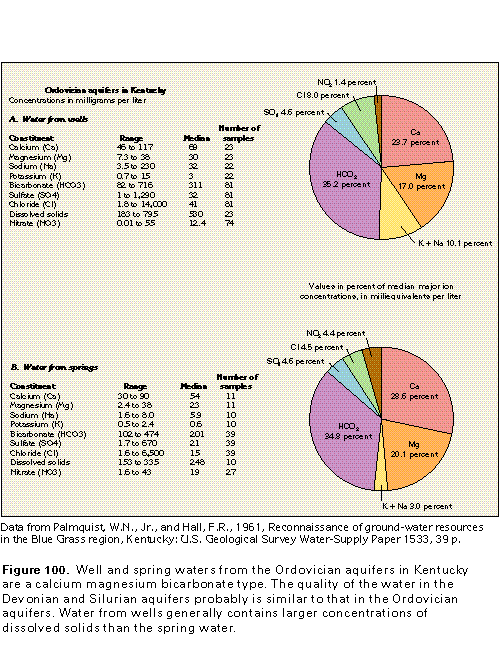
The water from Ordovician aquifers in Kentucky is a hard, calcium magnesium bicarbonate type (fig. 100). The abundance of these dominant ions results primarily from dissolution of the carbonate rocks as slightly acidic recharge water moves through the aquifers.
The quality of the water from wells completed in the Ordovician aquifer in Kentucky (fig. 100A) and from springs that issue from the same aquifer (fig. 100B) is similar. The concentrations of constituents in the Devonian and Silurian aquifers probably are similar to those in water from the Ordovician aquifers. Dissolved-solids concentrations generally are larger in water from wells than from springs (fig. 100). In addition, the water from wells contains larger concentrations of chloride, sodium, and potassium than the spring water.
As with the Mississippian aquifers, contaminated and turbid waters are common problems for the users of water from the limestone and dolomite aquifers in Devonian, Silurian, and Ordovician rocks in Kentucky and Tennessee. The thin soil and residuum and the presence of solution features, such as sinkholes, swallow holes, and solution-enlarged fractures, allow water from the land surface to recharge the aquifer directly and rapidly. Contaminated and sediment-laden waters can then spread rapidly through the system of interconnected solution openings to eventually reach wells and springs.
Fresh Ground-Water Withdrawals
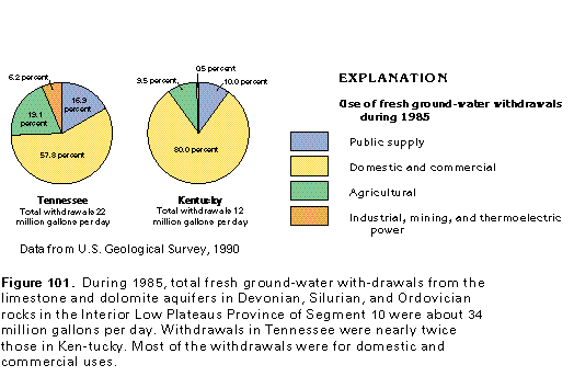
More fresh ground water is withdrawn from the limestone and dolomite aquifers in Devonian, Silurian, and Ordovician rocks in Tennessee than in Kentucky. About 22 million gallons per day were withdrawn from these aquifers in Tennessee and about 12 million gallons per day were withdrawn in Kentucky during 1985 (fig. 101). During the same year, about 93 percent of the ground water withdrawn in Tennessee (about 21 million gallons per day) and about 99 percent of that withdrawn in Kentucky (nearly 12 million gallons per day) were pumped for public-supply, domestic and commercial, and agricultural uses. Most of the withdrawals in both States were for domestic and commercial purposes. Withdrawals for domestic and commercial uses during 1985 amounted to about 13 million gallons per day in Tennessee and about 10 million gallons per day in Kentucky. Public-supply withdrawals were about 4 million gallons per day in Tennessee and about 1 million gallons per day in Kentucky. Withdrawals for agricultural purposes during 1985 amounted to about 4 million gallons per day in Tennessee and about 1 million gallons per day in Kentucky. The remainder of the withdrawals during 1985 were for industrial and mining uses and were greater than 1 million gallons per day in Tennessee but less than 100,000 gallons per day in Kentucky. No water was withdrawn for thermoelectric power purposes in either State.