INTRODUCTION
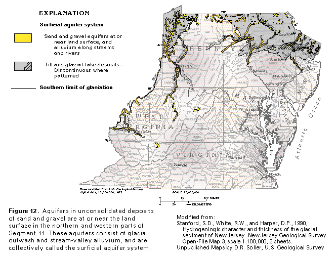
The surficial aquifer system is in the northern and western parts of Segment 11 (fig. 12) and consists of aquifers in unconsolidated sand and gravel deposits of Quaternary age. The aquifer system is in parts of all the physiographic provinces in the segment except the Coastal Plain. Most of the individual aquifers that compose the system are not hydraulically connected, but share common geologic and hydrologic characteristics and are therefore considered to be an aquifer system. Unconsolidated sand and gravel deposits that are the uppermost aquifers in parts of the Coastal Plain in Segment 11 are not mapped as part of the surficial aquifer system because they function as part of the Northern Atlantic Coastal Plain aquifer system.
Two principal types of unconsolidated sediments compose the surficial aquifer system. The first, and most widespread, type consists of sediments deposited by Pleistocene continental glaciers or by meltwater from the glaciers. The second type is Holocene alluvium in the valleys of major streams. The glacial sediments are restricted to the northern parts of Pennsylvania and New Jersey; the alluvial deposits are scattered through parts of West Virginia, Pennsylvania, and New Jersey (fig. 12). Some of the alluvial deposits are reworked glacial sediments.
HYDROGEOLOGIC SETTING
Glacial deposits consist mostly of clay, silt, sand, and gravel in various combinations, but also include cobbles and boulders. The general term "glacial drift" is used for all types of glacial deposits, regardless of the particle size or the degree of sorting of the deposits, or how the deposits were emplaced. The glacial drift in Segment 11 was deposited during several advances and retreats of continental ice sheets. The most recent and widespread glacial stage, termed "Wisconsinan," ended only about 12,000 years ago; the last ice sheet, however, retreated out of the area of Segment 11 about 17,000 years ago.
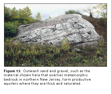
Glacial ice and meltwater from the ice laid down several different types of deposits. Till, which is an unstratified, unsorted mixture of material that ranges in particle size from clay to boulders, was deposited under the ice or directly in front of the ice sheet. Deposits of till are the most extensive glacial deposits in Segment 11, but the till is not an aquifer. Glacial-lake deposits of clay and silt, which were laid down in lakes that formed between ice lobes or where the ice blocked pre-glacial streams, likewise are not aquifers. Outwash deposits, by contrast, generally consist of stratified sand and gravel (fig. 13) that form productive aquifers. Most of the outwash deposits in Segment 11 are in valleys; the intervening hills are mantled with till or underlain by consolidated rock. The ice sheets greatly altered topography and drainage in the part of the segment that has been glaciated. Before or during the Pleistocene Epoch, some streams in the glaciated area cut their channels as much as 300 feet deeper than their present streambeds. In some places, erosion of bedrock hills by the thick ice sheets smoothed and rounded the preglacial topography and deposition of glacial drift, primarily in bedrock valleys, further subdued the original relief of the bedrock surface. In other places, the ice scoured deep troughs in the bedrock and stripped weathered bedrock away from hills, thus increasing the original relief.
Streams that flowed northward or northwestward typically were blocked by the ice sheets that advanced from the north and northeast. Flow direction was reversed in some of the north-flowing streams; others resumed their northward flow after the ice retreated; and a few were overridden by thick ice and permanently obliterated. New channels were cut by meltwater streams in some places, and some of these new channels connected parts of separate preglacial streams. The present course of the Ohio River was formed during the Pleistocene Epoch as a composite of newly cut channel segments and connected, old channel segments. Some of the deeply cut meltwater stream valleys were later filled to their present levels with glacial deposits and alluvium.
In areas where streams drained away from the glacial ice, stratified glacial drift was deposited in the stream valleys, mostly when the ice was stagnant or when the ice sheet was melting. Sand and gravel were deposited (fig. 14) as deltas or fluvial deposits at the ice margins or in glacial lakes or as fluvial valley-train deposits downstream from the ice margin. The coarse sand and gravel form productive aquifers that commonly are interspersed with the clay and silt confining beds deposited in small lakes in the valleys. Some of the valley-train sand deposits extend for many miles, as in parts of the valleys of the Allegheny and the Susquehanna Rivers.
Sand and gravel deposited as alluvium along the valleys of major streams also form productive aquifers. Some of the alluvium consists of reworked glacial deposits that were eroded and transported downstream during and following the last retreat of the ice. Reworked glacial material is most common in southward-flowing streams, such as the Allegheny and the Ohio Rivers, that have their headwaters in glaciated areas. Although some of the deposits of reworked glacial material are in dry terraces above the water table, most of them are saturated, and some, such as the gravel deposits along the upper reaches of the Ohio River, form highly productive aquifers. Alluvium in the valleys of northward-flowing streams consists of material that has been weathered and eroded from exposed consolidated sedimentary rocks. The alluvium along the northward-flowing rivers, such as the Kanawha in West Virginia and the Monongahela in Pennsylvania, generally is finer grained than that along the southward-flowing rivers and thus yields less water to wells.
GROUND-WATER FLOW
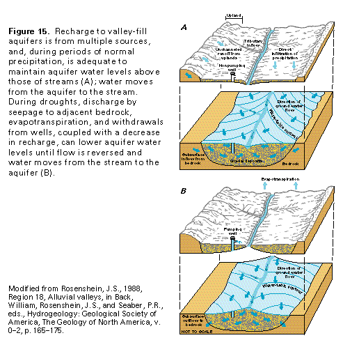
Most of the productive aquifers in the surficial aquifer system consist of valley-fill deposits of coarse-grained glacial or alluvial deposits, or both, and contain water under mostly unconfined conditions. In New Jersey, fine-grained glacial-lake sediments overlie aquifers in coarse-grained glacial sediments in many places and create confined conditions in the aquifers. The valley-fill aquifers receive most of their recharge from runoff of precipitation that falls on the surrounding uplands that are underlain by till or bedrock, both of which are less permeable than the valley-fill deposits. Some recharge is by infiltration of precipitation that falls directly on the valley-fill aquifers, and some is by inflow from adjacent bedrock (fig. 15A). Studies have concluded, however, that from 60 to 75 percent of the recharge to the valley-fill aquifers is from upland runoff, some of which is unchanneled, but most of which is in tributary streams and enters the aquifers as seepage through the streambeds. The higher recharge percentages are for aquifers in valleys that are less than one-half mile wide. The valley-fill aquifers discharge primarily to streams that flow in the valleys when the water level in the aquifer is higher than that in the stream (fig. 15A); during drought conditions, water levels in the aquifer can decline until the direction of flow is reversed and water moves from the stream to the aquifer (fig. 15B). The thickness and permeability of the bottom sediment in the stream determine the rate at which water can move between the stream and the aquifer. Some discharge from the valley-fill aquifers also is by outflow to adjacent bedrock, evapotranspiration, and withdrawals from wells (fig. 15B).
Base flow of a stream is maintained by ground-water discharge and is a good indication of the water-yielding capacity of the aquifer that provides the base flow. Base-flow characteristics in Segment 11 vary with the type of rocks or deposits through which the stream flows. Streams that flow on bedrock have minimal base flow and often become dry because the limited amount of fracture and pore space in the bedrock permits little water to be stored and subsequently released to the stream. In contrast, streams in valleys partly filled with glacial outwash and bordered by bedrock that is covered with till have large, sustained base flow because thick glacial deposits can store and slowly release large quantities of water even where they consist of low-permeability till. Base flow has been estimated by some studies to account for more than 70 percent of the total runoff in the glaciated parts of the Appalachian Plateaus Province but accounts for only about 50 percent of the total runoff in the unglaciated parts of the province.
POTENTIAL WELL YIELDS
The considerable variation in potential yields of wells completed in the aquifers of the surficial aquifer system from place to place depends on the saturated thickness of the unconsolidated sediment, its coarseness, degree of sorting, and extent. Sustained well yields are dependent on recharge rates. Adequate recharge usually is not a problem because most of the aquifers are in the valleys of perennial streams from which flow to wells can be induced, especially if the wells are located near the streams.
The principal aquifers of the surficial aquifer system in New Jersey consist of glacial deposits of sand and gravel that partly fill bedrock valleys. Overlying till or glacial-lake deposits of silt commonly confine the aquifers, although they are unconfined in places. The combined thickness of coarse- and fine-grained valley-fill material is as much as 350 feet in some valleys. Yields of most large-diameter wells range from 130 to 800 gallons per minute, but some wells yield as much as 2,200 gallons per minute.
In northeastern Pennsylvania, yields from wells completed in glacial-deposit aquifers are about 400 to 750 gallons per minute near the confluence of the Lehigh and the Delaware Rivers. Elsewhere in the area, wells completed in the same type of material yield as much as 1,300 gallons per minute.
In western Pennsylvania, reported yields of wells completed in glacial gravels and alluvium along the Allegheny and the Ohio Rivers, stratified drift along other streams, and abandoned, filled channels within the glaciated area generally range from 200 to 1,200 gallons per minute. Locally, however, yields of as much as 2,000 gallons per minute have been reported, and along the West Branch of the Susquehanna River in west-central Pennsylvania, a few wells yield 1,000 to 3,000 gallons per minute. Wells located on alluvial terraces along north-flowing streams south of the limits of glaciation yield only 5 to 10 gallons per minute.
In West Virginia, the valleys of north-flowing tributaries of the Ohio River contain as much as 75 feet of alluvium; however, only the lower part of the alluvium is saturated. Yields
of wells completed in the alluvium are as much as 105 gallons per minute along the Little Kanawha River and 150 gallons per minute along the Kanawha River. Along the Ohio River, yields of 100 to 1,000 gallons per minute are reported from standard vertical wells completed in the alluvium. Yields from collector wells, which are bored or excavated horizontally, can be even higher.
GROUND-WATER QUALITY
The chemical quality of water in the aquifers of the surficial aquifer system is somewhat variable but generally is suitable for municipal supplies and most other purposes. Most of the water in the upper parts of the aquifers is not highly mineralized.
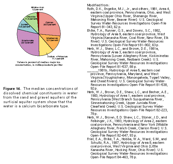
With the exception of local limestone and dolomite gravel in glacial deposits, the unconsolidated sand and gravel aquifers of the surficial aquifer system consist primarily of siliceous material, which is not very soluble. Furthermore, the aquifers are at or near the land surface and commonly are thin. Much of the recharge water enters the aquifers as runoff from adjacent highlands or directly from precipitation on the aquifers and the residence time of the water in the aquifer is generally short. The net effect of these factors is that the water contains little dissolved mineral material and has an average dissolved-solids concentration of about 250 milligrams per liter. Because hardness (caused principally by calcium and magnesium ions) averages about 140 milligrams per liter, the water is classified as hard. The median hydrogen ion concentration, which is measured in pH units, is 7.2. Thus, the water is slightly basic, because of the dissolution of calcium and magnesium carbonate, which raises the pH. The water is a calcium bicarbonate type (fig. 16).
Chloride concentrations average about 29 milligrams per liter but locally are as much as 1,200 milligrams per liter. Sulfate concentrations also average about 29 milligrams per liter but are as much as 670 milligrams per liter. Large concentrations of chloride and sulfate in the unconsolidated sand and gravel aquifers might be due to discharge from underlying bedrock aquifers that contain highly mineralized water.
The median iron concentration is 100 micrograms per liter, but concentrations of as much as 552,000 micrograms per liter have been measured. Locally, large concentrations of nitrate are probably the result of surface contamination by fertilizers, animal wastes, or sewage. Shallow aquifers, such as those of the surficial aquifer system, are particularly vulnerable to contamination.
FRESH GROUND-WATER WITHDRAWALS
Total freshwater withdrawals from unconsolidated sand and gravel aquifers of the surficial aquifer system in the Piedmont, the Blue Ridge, the Valley and Ridge, the Appalachian Plateaus, and the Central Lowland Provinces of Segment 11 were estimated to be 320 million gallons per day during 1985. About 140 million gallons per day was used for domestic and commercial purposes, and about 102 million gallons per day was withdrawn for public supply (fig. 17). Industrial, mining, and thermoelectric power uses accounted for withdrawals of about 62 million gallons per day. About 16 million gallons per day was withdrawn for agricultural use.