INTRODUCTION
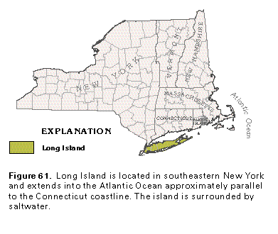
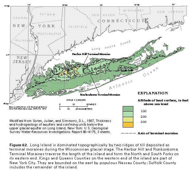
Long Island, in southeastern New York, extends east-northeast about 120 miles into the Atlantic Ocean parallel to the Connecticut coastline (fig. 61). The island is surrounded by saltwater-Long Island Sound on the north, the Atlantic Ocean on the east and south, and the Hudson estuary and East River on the west (fig. 62). The western end of the island is part of New York City (Kings and Queens Counties), which is bounded on the east by the populous Nassau County. The less populous Suffolk County includes the remainder of the island.
About 2.8 million people lived on Long Island during 1985 and depended on ground water for drinking and most other uses. Ground water is virtually the only source of supply on the island. During 1985, about 470 million gallons per day of fresh ground water was withdrawn largely for public supply and industrial purposes.
Topographically, Long Island is dominated by two subparallel ridges that are terminal moraines-the Harbor Hill Terminal Moraine and the Ronkonkoma Terminal Moraine (fig. 62)-which were deposited during the Wisconsinan glacial stage. The moraines merge in the west but separate in central Nassau County and trend eastward the length of the island. They form the North and South Forks of the eastern end of the island. The land surface generally slopes both to the north and to the south from the two moraines; gently to the south and more abruptly to the north. Barrier beaches form the south edge of the island and enclose Great South Bay.
The moraines on Long Island mark the terminus of glaciation. The sandy morainal material is mingled with outwash sand and gravel that covers much of the remainder of the island and forms a thick and permeable aquifer similar to the Cape Cod glacial aquifer.
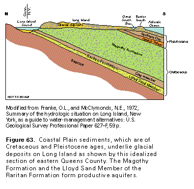
Long Island also is underlain by Coastal Plain sediments of Cretaceous and Pleistocene ages (fig. 63) that are hydraulically connected with the glacial aquifer. Because the glacial and Coastal Plain deposits cannot be hydraulically separated and generally function as a hydrologic unit, they are discussed together in this chapter.
HYDROGEOLOGY
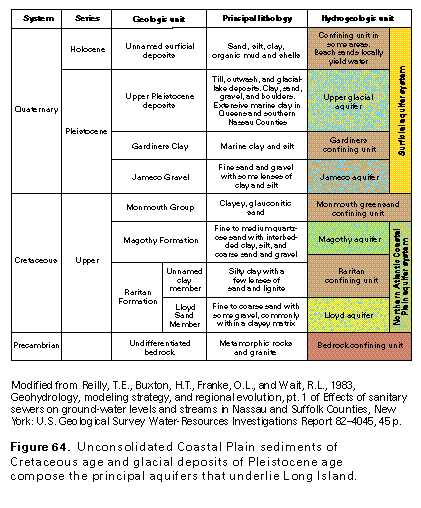
Three principal aquifers underlie Long Island. They are unconsolidated deposits of Pleistocene age, referred to as the upper glacial aquifer (fig. 64), and unconsolidated deposits of Cretaceous age, which include the Magothy aquifer above and the Lloyd aquifer below. The three aquifers are bounded above by the water table and below by the crystalline bedrock surface. Laterally, usable freshwater in the aquifers is bounded by a freshwater-saltwater transition zone that surrounds the island. A fourth aquifer, the Jameco, which is composed of sediments of Pleistocene age, is present only in Kings and the southern half of Queens Counties. It is areally limited and little used.
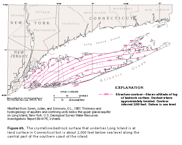
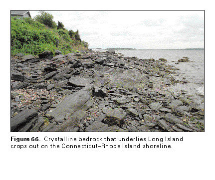
The surface of the crystalline bedrock that underlies Long Island slopes southward at about 55 to 60 feet per mile in an arcuate pattern (fig. 65). The bedrock does not crop out on Long Island, but is exposed at the Connecticut-Rhode Island shoreline north of Long Island Sound (fig. 66) and on Manhattan Island across the East River from the western end of Long Island. The crystalline-bedrock surface is nearly 2,000 feet below sea level along the central part of the south coast of Long Island (fig. 65). This bedrock foundation has negligible permeability and functions as a hydrologic boundary or base for the Long Island ground-water flow system.
The unconsolidated Raritan Formation (fig. 64) of Cretaceous age dips and thickens southward and overlies the crystalline-bedrock surface. The Raritan consists of two members-the lower Lloyd Sand Member and an upper, unnamed clay member.
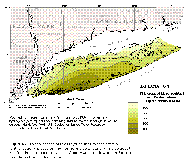
The Lloyd Sand Member of the Raritan Formation consists of fine to coarse sand and gravel commonly within a clayey matrix and forms the Lloyd aquifer, which is the lowermost principal aquifer on Long Island. The Lloyd aquifer is missing in the northwestern part of the island where the Lloyd Sand Member was extensively eroded prior to glaciation. The Lloyd aquifer ranges in thickness from a featheredge in places on the north side of the island to about 500 feet in southeastern Nassau County and southwestern Suffolk County on the south side (fig. 67). The depth to the top of the aquifer ranges from about 200 to about 1,500 feet below sea level.
The clay member of the Raritan Formation has a maximum thickness of about 300 feet and consists of massive silty clay with a few lenses of sand and lignite. The clay member forms a leaky confining unit.
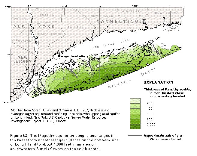
The Magothy Formation, which unconformably overlies the Raritan Formation, is composed of unconsolidated fine to medium quartzose sand with layers and lenses of clay, silt, and coarse sand and gravel. The coarsest material is present in the lower 50 to 100 feet of the formation. The Magothy was extensively eroded prior to glaciation and is missing in the northwestern part of the island. The depth to the top of the Magothy Formation ranges from land surface in isolated outcrop areas on the north shore to about 600 feet below land surface on the south shore. The Magothy Formation comprises the Magothy aquifer, which ranges in thickness from a featheredge in places on the north side of the island to about 1,000 feet in an area of southwestern Suffolk County on the south shore (fig. 68).
Pre-Pleistocene streams eroded several deep channels in the Magothy surface, two of which extend southeastward across the entire island (fig. 68). The channel in Queens County was probably eroded by the ancestral Hudson River. The other channel, which extends from the eastern end of the North Fork of the island southeastward across the South Fork, was probably eroded by the ancestral Connecticut River.
Two other significant channels were eroded in the Magothy Formation surface in Suffolk County. The Huntington buried valley extends northwestward toward Long Island Sound about 5 miles east of the Nassau-Suffolk County line (fig. 68). The other valley, which forms the Ronkonkoma Basin, also extends northwestward toward Long Island Sound about 15 miles east of the Nassau-Suffolk County line.
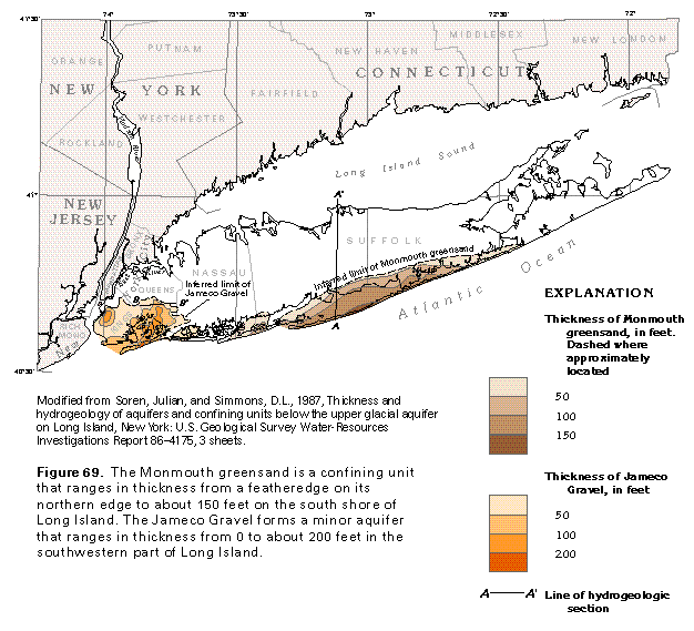
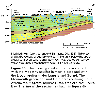
The Monmouth Group (fig. 64) on Long Island is represented by the Monmouth greensand, which is a clayey, glauconitic unit of Cretaceous age similar in hydraulic character to the Raritan confining unit. The Monmouth greensand unconformably overlies the Magothy aquifer along the southern edge of the island (figs. 69, 70) and dips and thickens to the south. The greensand ranges in thickness from a featheredge to about 150 feet (fig. 70). The greensand mostly underlies the bays between the barrier islands and the main part of Long Island and extends from near the Nassau-Suffolk County line eastward to the western part of the South Fork. The Monmouth greensand is a confining unit where it overlies the Magothy aquifer.
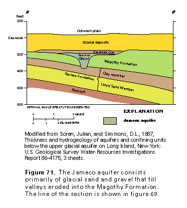
The Jameco Gravel is the basal deposit of Pleistocene age (fig. 64) and underlies parts of Kings and Queens Counties on the western end of Long Island (fig. 69). The Jameco ranges from a fine sand to gravel with some lenses of clay
and silt and, for the most part, fills valleys eroded into the underlying Magothy Formation (fig. 71). The Jameco Gravel ranges in thickness from a featheredge to about 200 feet in south-central Queens County (fig. 69) and forms the local Jameco aquifer.
The Jameco Gravel is overlain by the Gardiners Clay, which is a marine deposit of Pleistocene age that underlies most of Kings County and the southern one-half of Queens County and extends eastward along the south shore area to the middle of the South Fork. The Gardiners Clay ranges in thickness from a featheredge to about 100 feet. The clay is thickest in Queens County and thins to about 50 feet in the remainder of its extent. The Gardiners Clay is clayey and silty in the western one-half of its extent but becomes increasingly sandy to the east. Where present, the clay forms a confining unit that separates the upper glacial aquifer from the Magothy and Jameco aquifers.
Pleistocene glacial deposits blanket Long Island and range in thickness from a featheredge to about 600 feet in the Ronkonkoma Basin. Till, which is composed of unsorted and unstratified clay, silt, sand, gravel, cobbles, and boulders, forms the Harbor Hill and Ronkonkoma Terminal Moraines (fig. 62). Outwash deposits that consist primarily of fine to coarse quartzose sand and gravel are exposed at land surface between and south of the two moraines. Outwash deposits also are interbedded with till in and north of the moraines. Outwash and other coarse-grained materials form the upper glacial aquifer.
Glacial-lake deposits that consist of clay, silt, and some sand and gravel layers are present within the upper glacial aquifer in central and eastern Long Island. Marine clay of Pleistocene age also is present within the upper glacial aquifer in Queens and southern Nassau Counties. These glacial-lake deposits and marine sediments, along with unsorted and unstratified till, form local confining units where they overlie permeable outwash deposits.
Holocene deposits, which are as much as 50 feet thick and consist of salt-marsh deposits, stream alluvium, and beach sands, occur locally throughout the island. Holocene deposits consist of sand, clay, silt, organic muck, and shells. They are at land surface and generally overlie Pleistocene deposits. They are either unsaturated or too thin and discontinuous to form aquifers. In some areas, they form local confining units.
GROUND-WATER FLOW
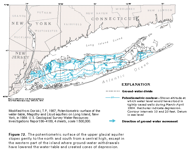
On Long Island, water from precipitation that is not evapotranspired or that does not run off in storm drains or streams infiltrates the permeable soil and moves both downward and horizontally through the porous rocks in response to gravitational or withdrawal-induced gradients. A map of the potentiometric surface of each of the principal aquifers represents the pressure surface to which water will rise in tightly cased wells open to the aquifer and indicates the general direction of ground-water movement, which is down the hydraulic gradient and generally perpendicular to the potentiometric contours.
The potentiometric surfaces of the upper glacial and Magothy aquifers in March and April 1984 and of the Lloyd aquifer in January 1984 are shown in figures 72 , 73, and 74. The potentiometric surface of the unconfined upper glacial aquifer (fig. 72) is the water table, which is the top of the saturated zone. Ground-water divides separate the movement of ground water northward to Long Island Sound and southward to Great South Bay and the Atlantic Ocean.
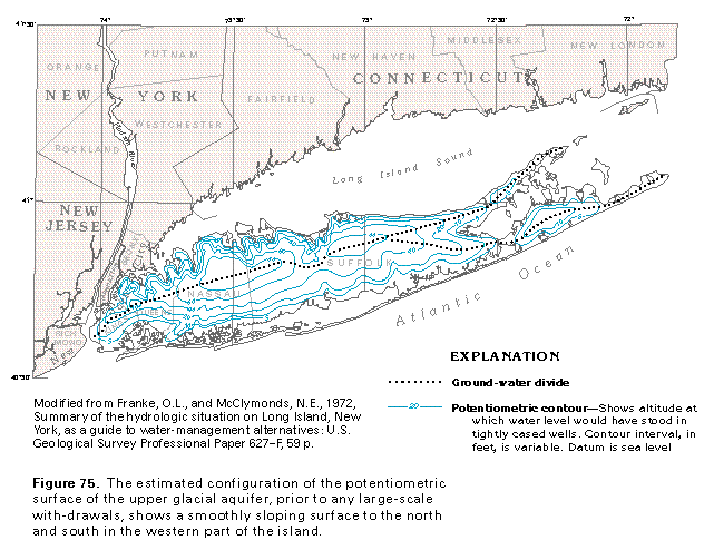
The estimated configuration of the potentiometric surface of the upper glacial aquifer in Kings and Queens Counties under natural (predevelopment) conditions is shown in figure 75. Ground-water withdrawals in these counties have lowered the potentiometric surface, changed its configuration, and produced characteristic circular cones of depression centered around the areas of withdrawal as shown in figure 72.
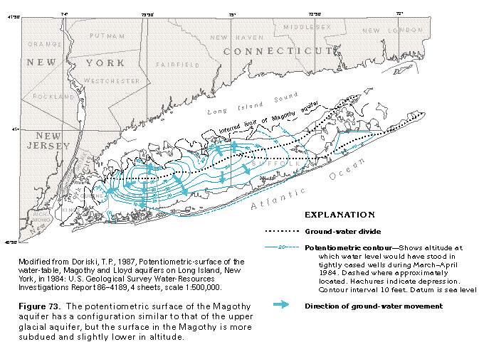
The potentiometric surface of the Magothy aquifer (fig. 73) has a configuration similar to that of the upper glacial aquifer, but is more subdued and slightly lower in altitude. The ground-water divide on the Magothy potentiometric surface nearly coincides with that on the potentiometric surface of the upper glacial aquifer. Ground-water withdrawals from the Magothy aquifer in Kings and Queens Counties also have lowered water levels in the aquifer below natural levels.
The Magothy aquifer is mostly unconfined, as is the upper glacial aquifer, and the two aquifers function hydrau-lically as one aquifer. However, because the potentiometric surface of the Magothy is slightly lower than that of the upper glacial aquifer, the vertical gradient is downward, and water moves downward from the upper glacial aquifer to recharge the Magothy.
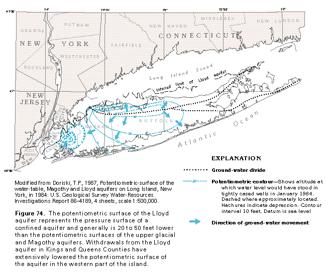
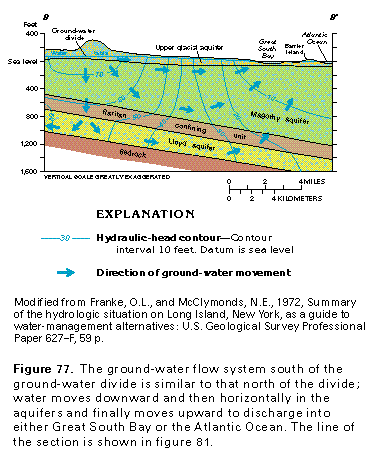
The Lloyd aquifer is confined by the Raritan confining unit (fig. 64), and the potentiometric surface of the aquifer is shown in figure 74. The potentiometric surface is above the base of the confining unit and rises to an altitude of 20 to 50 feet below that of the Magothy potentiometric surface (figs. 76, 77) in Nassau and Suffolk Counties. Thus, the vertical gradient is downward from the Magothy aquifer to the Lloyd aquifer, and water moves downward from the Magothy aquifer to recharge the Lloyd aquifer.
Ground-water withdrawals from the Lloyd aquifer in Kings and Queens Counties have lowered water levels in those two counties and in much of Nassau County. A large cone of depression dominates the potentiometric surface of the Lloyd aquifer in the western part of Long Island (fig. 74); water levels are more than 20 feet below sea level in an area that extends from Kings and Queens Counties into the western and southern parts of Nassau County. The large-scale withdrawals have shifted the ground-water divide in the Lloyd aquifer northward in much of the western part of the island. Elsewhere, the divide is unaffected and is nearly coincident with that of the upper glacial and the Magothy aquifers.
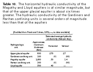
Movement of water through the unconsolidated deposits that underlie Long Island is a function of the hydraulic conductivity (the capacity of the deposits to transmit water). The estimated average hydraulic conductivity in the horizontal and vertical directions of the major hydrogeologic units on Long Island is presented in table 10. The horizontal hydraulic conductivity of the Lloyd and the Magothy aquifers is of a similar magnitude but that of the upper glacial aquifer is about six times greater. The horizontal hydraulic conductivity of the Gardiners and the Raritan confining units is several orders of magnitude less than that of the aquifers, and the vertical hydraulic conductivity of the upper two aquifers and both confining units is an order of magnitude less than their horizontal hydraulic conductivity. The horizontal hydraulic conductivity of the upper two aquifers is 10 to about 36 times that of their vertical hydraulic conductivity. Thus, under an equal hydraulic gradient, ground water moves more rapidly horizontally than vertically through these units, more rapidly horizontally through aquifers than through the confining units, and more rapidly through the upper glacial aquifer than through the Magothy and the Lloyd aquifers.
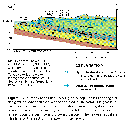
The general pattern of water movement in each of the aquifers, as indicated in figures 72-74, is from the ground-water divides northward to Long Island Sound and southward to Great South Bay and the Atlantic Ocean. The character of the flow system at depth is shown by hydrogeologic sections through northern Nassau (fig. 76) and southwestern Suffolk Counties (fig. 77). The distribution of hydraulic heads in the three aquifers is shown in figures 76 and 77 by hydraulic-head contours. Water movement is perpendicular to the lines and from the highest to the lowest hydraulic head. Water enters the system as recharge at the ground-water divides where the hydraulic head is highest, then moves northward, southward, and downward, all directions of decreasing hydraulic head. Thus, some of the water from precipitation that percolates downward into the upper glacial aquifer continues to move downward into the Magothy aquifer, through the Raritan confining unit, and into the Lloyd aquifer. The ground-water divide of the upper glacial aquifer is reflected in the Magothy and the Lloyd aquifers in figures 76 and 77 along the lines of section that represent natural, predevelopment conditions. Under actual withdrawal conditions, the divide of the Lloyd aquifer would be shifted northward.
The water that reaches each of the aquifers moves horizontally away from the divide toward discharge areas, but there also is a downward component that moves water into the underlying aquifers (figs. 76, 77). At discharge areas, water at depth moves nearly vertically upward either through overlying aquifers and confining units or directly to aquifer subcrop areas where the water is discharged to the peripheral saltwater bodies. Note that hydraulic-head contours are deflected by the Raritan confining unit because its low permeability retards the downward movement of the water. Even though the clay has very low permeability, water does move through this confining unit.
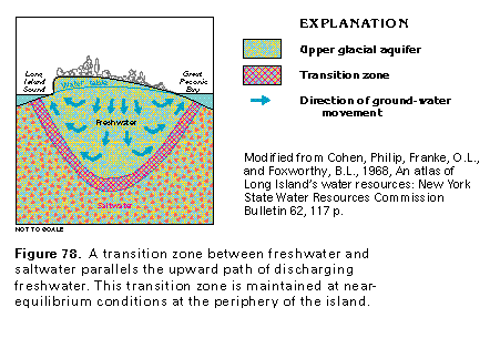
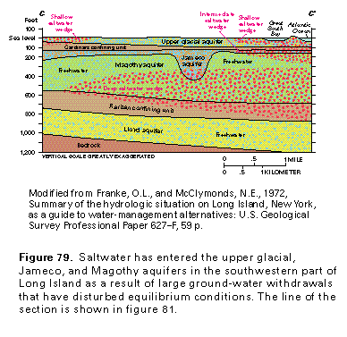
This flow system is present throughout Long Island where natural conditions prevail. Fresh ground water is discharged along most of the periphery of the island. The discharge of freshwater, which is less dense than saltwater, prevents the saltwater from entering the aquifers. A transition zone between freshwater and saltwater is maintained, under equilibrium conditions at the periphery of the island, that parallels the upward curve of the discharging freshwater (fig. 78). Equilibrium con-ditions, however, have been disturbed in Kings, Queens, and part of Nassau Counties where ground-water withdrawals have lowered hydraulic heads in each of the aquifers (figs. 72 -74) and, in some cases, reversed the direction of flow so that water moves toward the pumping wells. As a consequence, wedge-shaped bodies of saltwater have entered the upper glacial, the Jameco, and the Magothy aquifers in the southwestern part of the island, as shown in figure 79. Saltwater also has undoubtedly moved inland in the Lloyd aquifer, but data are not available to locate the present position of the saltwater wedge.
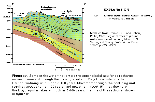
The character of the regional ground-water flow system might be better visualized with a comparative time scale. The estimated time required for water to move through parts of the system is shown in figure 80. Water that moves into the upper glacial aquifer at the ground-water divide will move downward through the upper glacial and the Magothy aquifers to the Raritan confining unit in about 100 years. An additional 100 years is required for the water to move through the confining unit. Movement about 15 miles downdip to the south in the Lloyd aquifer requires as much as 3,000 years.
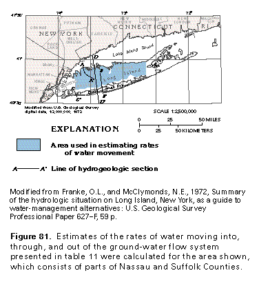
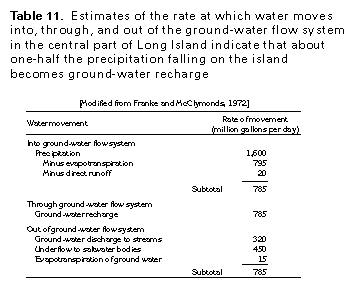
The rate of water moving into, through, and out of the ground-water flow system of Long Island has been estimated for parts of Nassau and Suffolk Counties as indicated on figure 81. The estimated rates at which water moves through the principal parts of the system in that area, in million gallons per day, are listed in table 11. An average of about 1,600 million gallons per day of precipitation falls on Long Island; of that, only about 1.3 percent, or about 20 million gallons per day, runs off directly to streams. Of the remaining water, about 50 percent, or nearly 795 million gallons per day, is returned to the atmosphere by evapotranspiration, and about 49 percent, or nearly 785 million gallons per day, infiltrates the ground as recharge. About 2 percent of the water that enters the ground, or 15 million gallons per day, is returned to the atmosphere as ground-water evapotranspiration. The remaining 770 million gallons per day moves downward to recharge the aquifers. The aquifers discharge freshwater back to the land surface as discharge to streams and to the peripheral saltwater bodies by underflow. Ground-water discharge to streams is about 41 percent of recharge, or about 320 million gallons per day. Underflow accounts for the remaining 57 percent of recharge, or about 450 million gallons per day.
GROUND-WATER QUALITY
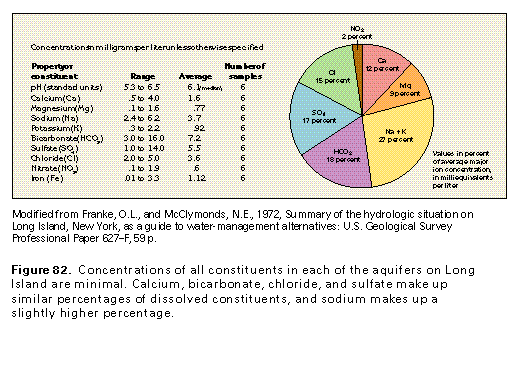
Generally, the chemical quality of water in the aquifers of Long Island is suitable for most uses, including human consumption (fig. 82). Concentrations of dissolved solids in water from each of the aquifers are exceptionally small-less than 40 milligrams per liter. Stream and lake water, which is largely derived from ground-water discharge, reflects these small concentrations, having similar dissolved-solids concentrations of less than 50 milligrams per liter. In places, larger concentra-tions of dissolved solids indicate mixing of freshwater with saltwater or contamination from sources at the land surface. Iron concentrations are locally excessive, and the pH of the water commonly is less than 6.0, which causes the water to be very corrosive to transmission pipes, pumps, and plumbing.
The changes in quality of water as it moves through the hydrologic system on Long Island are described in figure 83. Moisture-laden air that moves over the ocean picks up salty spray. Precipitation removes salt, dust, and gases from the atmosphere as it falls to Earth; the average dissolved-solids concentration of precipitation has been reported to be about 10 milligrams per liter. Evapotranspiration concentrates and increases the dissolved-solids concentration of the water. Natural processes, especially oxidation, modify dissolved-solids concentrations and the chemical character of the water in the zone of aeration. Flow through the saturated zone tends to increase the dissolved-solids concentration in the water but, because aquifer materials are virtually chemically inert, little change occurs.
Thus, the salient features of the natural water chemistry of the island are (1) natural freshwater has a remarkably small dissolved-solids concentration, (2) the chemically inert mate-rials that form the aquifer cause little change in the dissolved-solids concentration of the water as it moves through the ground-water flow system, (3) mixing of freshwater and saltwater in the transition zone results in a sodium-chloride-type water with large concentrations of dissolved solids, and (4) the pH of ground water is commonly less than 6.0, which causes the water to be corrosive.
Ground-water contamination from various sources is a problem of long standing on Long Island. Saltwater encroachment from excessive ground-water withdrawals has rendered much of the ground water in Kings and Queens Counties unpotable. In Nassau and western Suffolk Counties, septic systems, oil and gas spills, and pesticide use have contaminated much of the upper glacial aquifer and forced most users to withdraw water from the Magothy aquifer. In the remainder of Suffolk County, which is not densely populated, contamination generally is not a serious problem. On the eastern end of the island, however, truck farming has introduced some pesticide contaminants into the upper glacial aquifer.
FRESH GROUND-WATER WITHDRAWALS
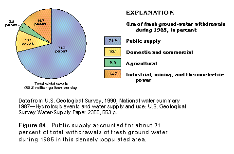
Fresh ground-water withdrawals on this densely populated and urbanized island were about 469 million gallons per day during 1985. Public supply accounted for about 71 per-cent of the withdrawals (fig. 84), and withdrawals for indus-trial, mining, and thermoelectric power were estimated to be about 15 percent. Combined domestic, commercial, and agricultural uses accounted for the remaining 14 percent of total withdrawals.