
INTRODUCTION
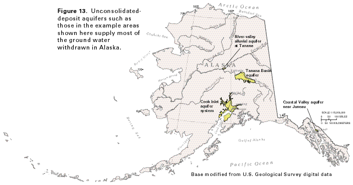
Unconsolidated deposits of sand and gravel that were deposited as alluvium or glacial outwash or both form the most productive aquifers in Alaska. These aquifers are present in lowland areas, primarily in the flood plains of major rivers, but in some places they also underlie low, rolling hills developed on alluvial-fan deposits that separate the flood plains from nearby mountains. In some areas, such as near Anchorage and Fairbanks, the unconsolidated-deposit aquifers are thick and widespread; in other places, they are present as narrow bands of alluvium in, and adjacent to, river channels. Because the State's major population centers and most of the agricultural development are in lowland areas near the rivers, the unconsolidated-deposit aquifers are an important source of water for public supply, domestic and commercial uses, and growing of crops. The geologic and hydrologic characteristics of these aquifers are described in the example areas shown in figure 13 and discussed in the following sections of this report.
COOK INLET AQUIFER SYSTEM
The Cook Inlet aquifer system underlies the lowland areas along
both sides of the northern part of Cook Inlet and the lower reaches
of the Susitna and the Matanuska Rivers which discharge into the
inlet (fig. 13). The aquifer system
provides part of the water supply for Anchorage and for smaller
cities and towns including Palmer, Kenai, and Soldotna. A large
number of domestic wells also obtain water from the aquifer system.
The unconsolidated sediments that make up the aquifer system consist of clay, silt, sand, gravel and boulders that were deposited primarily by glaciers but also by alluvial and colluvial processes. The sediments are complexly interbedded, with lenses and thin beds of sand and gravel interfingering with beds of clay, silt, and till. The stratigraphic complexity and great variability in grain size of the sediments causes discontinuity and variability in their hydraulic characteristics. Low-permeability sedimentary and metamorphic rocks underlie the aquifer system; locally, small volumes of water might move through these rocks and discharge upward to the unconsolidated-deposit aquifers.
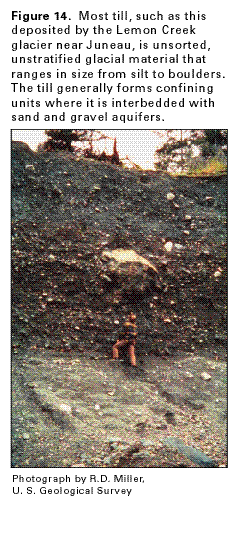
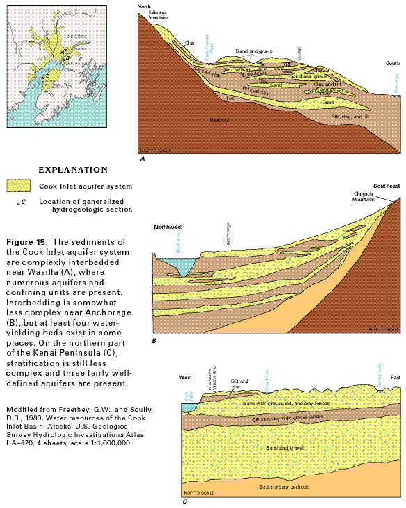
The sand and gravel beds that compose the water-yielding parts of the Cook Inlet aquifer system were deposited mostly as glacial outwash. Locally, alluvial deposits of sand and gravel are present in the upper parts of the aquifer system. Sand and gravel of colluvial origin flank the bedrock hills bordering the sedimentary basin that contains the aquifer system. Poorly sorted, unstratified till (fig. 14) or beds of clay and silt that represent glacial-lake or estuarine deposits are commonly interbedded with the sand and gravel. The till, clay, and silt have minimal permeability and commonly confine water in the unconsolidated-deposit aquifers. The relations of the aquifers and confining units at several places in the Cook Inlet aquifer system are shown in figure 15.
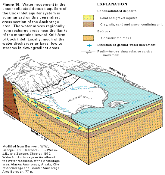
Water in the unconsolidated-deposit aquifers moves from recharge areas near the mountains, down the hydraulic gradient to discharge areas beneath major streams, Cook Inlet, or Knik Arm, the northern fork of the inlet. Where the aquifers are exposed at the land surface, such as the colluvial deposits on the flanks of the mountains or alluvial deposits near streams, they can receive recharge directly from precipitation on outcrop areas. Also, streams that flow from the low-permeability bedrock of the mountains onto sand and gravel deposits (fig. 16) lose water to the unconsolidated-deposit aquifers by leakage through the stream beds. The principal recharge areas for the aquifers are, thus, near the flanks of the mountain ranges. Small amounts of water might leak upward into the aquifers from local permeable zones in the underlying bedrock. Water moves laterally in the unconsolidated-deposit aquifers toward discharge areas, where it moves upward. Some water discharges by evapotranspiration from unconfined aquifers and withdrawals from wells.
The aquifers near Anchorage are the best known part of the Cook Inlet aquifer system. Two principal water-yielding zones contain most of the ground water (fig. 15B); a deep third zone is present in some places but is not well known. The upper zone contains water under unconfined (water table) conditions, whereas a fine-grained unit that underlies it creates confined (artesian) conditions in the lower zone. Hydraulic heads in both zones are sufficiently high to prevent intrusion of saline water from Cook Inlet or Knik Arm. Tidal fluctuations of as much as 37 feet in the inlet produce water-level fluctuations of as much as 4 feet in some wells, as a result of changes in pressure created by the rising and falling tide.
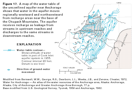
A map of the water table in the shallow, unconfined aquifer in the Anchorage area (fig.17) shows that water in this aquifer moves generally westward and northwestward from recharge areas at the eastern limit of the aquifer system. The configuration of the water table generally corresponds to the configuration of the land surface, but the water table contours are irregular where they cross streams. These irregularities reflect the hydrologic relations between the stream and the aquifer. Ship Creek, north of Anchorage, is a good example of these relations. Eastward from the airstrip at Elmendorf Air Force Base, the water-table contours bend downstream where they cross Ship Creek, indicating that the creek is losing water to the aquifer. Farther westward, the contours point upstream where they cross Ship Creek, indicating that the creek is gaining water from the aquifer in this area. Discharge from the aquifer to other streams is indicated by the shape of the water-table contours where they cross the downstream reaches of Chester Creek and Campbell Creek: the contours bend upstream in both areas.
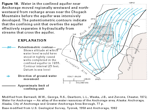
Before large ground-water withdrawals began, water in the confined aquifer near Anchorage moved regionally from recharge areas near the Chugach Mountains toward discharge areas at Cook Inlet and Knik Arm (fig. 18). The regional direction of movement was similar to that of water in the unconfined aquifer (compare figs. 17 and 18). However, the potentiometric surface of the confined aquifer indicates little or no hydraulic connection between the aquifer and streams that cross it. The fine-grained sediments that overlie this aquifer form an effective confining unit that hydraulically separates the aquifer not only from the streams, but also from the overlying unconfined aquifer. The effectiveness of the confining unit is also shown by the difference in altitude between the water table and the potentiometric surface of the confined aquifer. Water levels in the unconfined aquifer are 20 to 30 feet higher than the potentiometric levels of the confined aquifer everywhere the confining unit is present (compare figs. 17 and 18).
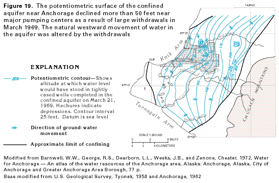
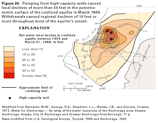
Withdrawal of water from high-capacity wells completed in the confined aquifer causes a decline in artesian pressure in the aquifer that is reflected by depressions on the aquifer's potentiometric surface (fig. 19). Large withdrawals from pumping centers near Elmendorf Air Force Base and the Glenn Highway caused the potentiometric surface of the aquifer to decline more than 50 feet by March 1969. Most of the ground water withdrawn in the Anchorage area is pumped from the confined aquifer. Withdrawals were sufficient to cause declines of 10 feet or more over an area of more than 40 square miles in March 1969 (fig. 20).
RIVER-VALLEY ALLUVIAL AQUIFERS
Alluvial deposits of sand and gravel that are present in the flood
plains and terraces of the major river valleys in Alaska, and
that are not connected to large alluvial fans, are called river-valley
alluvial aquifers in this report. The permeable sand and gravel
contain lenses and beds of silt and clay, rich in organic material
in some places, that retard the movement of ground water. The
alluvial deposits are present mostly in the zone of discontinuous
permafrost but also occur in the parts of the State where permafrost
is absent. Where present, the permafrost acts as an impermeable
barrier to ground-water flow, and creates confined conditions
for water that might be in unfrozen permeable beds beneath it.
Permafrost is absent beneath the beds of the major streams and
in the alluvium adjacent to the streams; thus, the alluvial aquifers
are in hydraulic connection with the streams and the movement
and level of ground water are directly influenced by the direction
of streamflow and the stage of the stream.
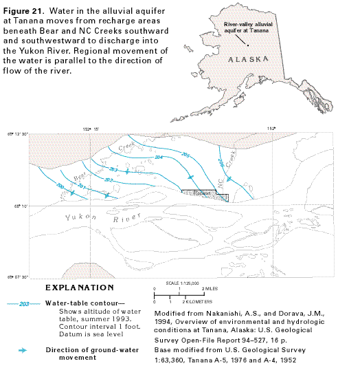
The aquifer in deposits of thick alluvium in the flood plain of the Yukon River at Tanana (fig. 13) is an example of a river-valley alluvial aquifer. The alluvial deposits at Tanana consist of sandy gravel and sandy silt, bordered at the sides of the river valley by silty deposits of colluvium that locally contain poorly sorted sand and gravel. Discontinuous permafrost is present in the alluvium except beneath the bed of the river and the flood plain immediately adjacent to it, where the warming effect of the river prevents permanent freezing of the ground. Adjacent to the river, therefore, ground water can move into and out of the riverbanks and stream bed, depending on the elevation of water in the river relative to the water level in the aquifer. Water levels in the aquifer at Tanana rise and fall in response to rises and falls of river level.
Field observations and computer simulation indicate that the movement of ground water near Tanana is toward the Yukon River from the valley walls of the river (fig. 21). Water recharges the aquifer by seepage through the beds of Bear and NC Creeks, and moves locally southward and southwestward to discharge to the Yukon River. Regionally, ground water moves westward, in the same direction as the flow of the river. The local movement of ground water is probably more complex than that shown in the figure because permafrost was assumed to be absent in the computer simulations; the general movement of the water, however, is thought to be correct.
TANANA BASIN AQUIFER
The water-yielding unconsolidated deposits along the Tanana River
and the flanks of the hills that surround the river basin (fig. 13) are called the Tanana Basin aquifer
in this report. The deposits consist of flood-plain alluvium near
the Tanana River and its tributaries, and alluvial-fan deposits
on the north flanks of the Alaska Range that borders the river
basin to the south. Locally, moraines deposited by glaciers in
valleys of the Alaska Range interfinger with the alluvium and
are considered to be slightly less permeable parts of the aquifer.
Although the alluvial deposits locally comprise several aquifers
separated by leaky confining units of silt and clay or by layers
of permafrost, they are usually treated as a single aquifer whose
permeability varies widely. The bedrock that underlies and surrounds
the alluvial deposits consists primarily of folded, faulted metamorphic
rocks, locally intruded by igneous rocks. The bedrock is generally
dense, compact, and yields little water; locally, however, where
it is fractured it will yield significant quantities of water
to wells. For example, numerous wells completed in bedrock in
the uplands north and northeast of Fairbanks yield sufficient
water for domestic supplies.
The alluvial deposits consist of well-stratified layers and lenses of silt, sand, and gravel. Broad alluvial fans of the large rivers that enter the Tanana drainage basin from the Alaska Range coalesce to form a continuous alluvial apron of coarse, permeable sediments at the base of the range. Permeable flood-plain alluvium is also present as narrow to wide bands along the Tanana River and its larger tributaries. The alluvial deposits are very thick in some places: wells have penetrated more than 600 feet of alluvium near Fairbanks and about 550 feet near the junction of the Delta and Tanana Rivers. Where the alluvium is thick and permeable, it is reported to yield as much as 3,000 gallons per minute to large-capacity wells. Water in these widespread alluvial deposits is mostly unconfined.
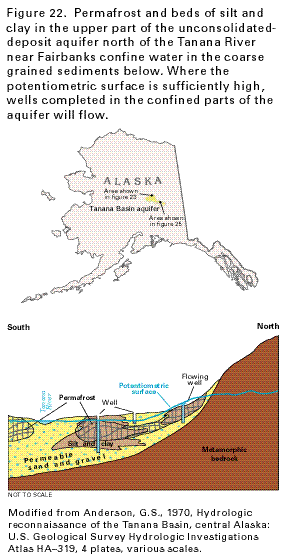
By contrast, water in the alluvial deposits north and east of the Tanana River occurs under unconfined and confined conditions. The sediments that compose the aquifer here are poorly sorted and, because the aquifer is in the zone of discontinuous permafrost, the permanently frozen ground, as well as beds and lenses of silt and clay, create confined conditions (fig. 22). The silt and clay deposits are more likely to be permanently frozen than beds of sand and gravel. Unfrozen alluvium is present beneath the permafrost, however, in most parts of the aquifer. The water is generally unconfined in the higher parts of the alluvial fans and in the alluvial plains near major streams. Artesian conditions are common on the lower slopes of the alluvial fans, and some wells completed in confined parts of the aquifer in these areas flow at the land surface.
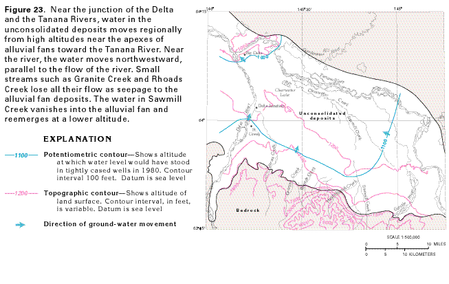
The occurrence and movement of ground water in the Tanana Basin aquifer are directly related to stream levels and streamflow. Most recharge to the aquifer is from seepage through streambeds, rather than from precipitation that falls directly on the aquifer. Water levels in streams that emerge from the bedrock of the Alaska Range onto permeable parts of the alluvial fans at the base of the mountains are much higher than the water table. Much of the flow of the larger streams, and all the flow of some smaller ones, is lost as the water seeps downward to recharge the aquifer. Water in the alluvial fans moves regionally toward the Tanana River and then downstream, in the same direction of flow as the river (fig. 23). Water discharges locally from the aquifer to springs and the lower reaches of Tanana River tributaries and regionally to the Tanana River; a small amount of water discharges to wells.
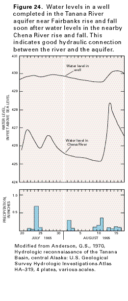
Water levels in wells located near streams fluctuate in direct response to rises and falls in stream water levels. A hydrograph comparing the water level in the Chena River at Fairbanks with that in a nearby well (fig. 24) shows that rises in river level are soon followed by rises in ground-water levels, indicating that the river and the aquifer are hydraulically connected. Both stream and aquifer water levels rise in response to precipitation events and snow melt.
During most of the year, the water level in a reach of the Tanana River near Fairbanks is higher than that of a nearby reach of the Chena River, a tributary of the Tanana. When this condition occurs, the shallower parts of the Tanana Basin aquifer between the two rivers receive recharge from the Tanana River and discharge to the Chena River (fig. 25). Thus, the local direction of shallow ground-water movement varies from the regional direction, which closely corresponds to the direction of stream flow. Deep ground-water flow, however, is thought to move under the Tanana River and toward the Chena River at all times of the year.
The chemical quality of water in the Tanana Basin aquifer is generally suitable for most uses. The water is a calcium bicarbonate or calcium magnesium bicarbonate type, and locally contains concentrations of iron and manganese that are higher than those recommended for drinking water by the U.S. Environmental Protection Agency.
COASTAL VALLEY AQUIFERS
Unconsolidated deposits of silt, sand, and gravel are common along
the lower reaches of streams in coastal valleys. The coastal valley
deposits near Juneau and in the Mendenhall River Valley (fig.
13) comprise a water-yielding unit that is an example of this
type of aquifer. The aquifer consists of alluvial and glacial
deposits of Quaternary age and contains water under unconfined
conditions in its upper parts. Beds of silt and clay that interfinger
with the permeable sand and gravel beds create confined conditions
in the lower parts of the aquifer. The fine-grained confining
units are mostly discontinuous but are effective enough in some
places to create artesian pressures sufficiently high so that
early wells completed in permeable strata beneath them would flow
at the land surface.
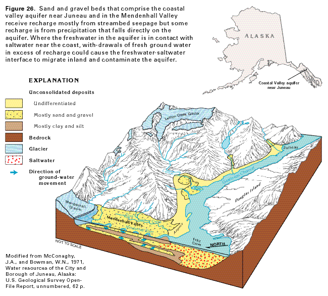
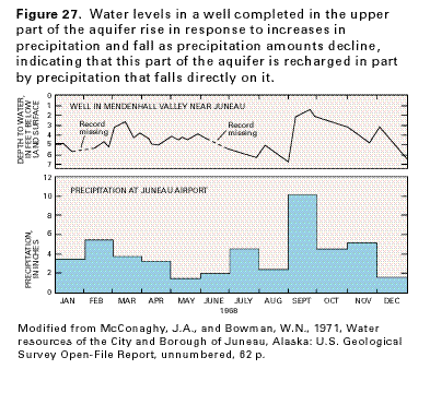
Water enters the aquifer primarily as seepage through the beds of streams such as the Mendenhall River where they flow across deposits of sand and gravel (fig. 26); a smaller amount of recharge to the aquifer is by precipitation that falls directly on permeable strata. Where permeable beds of the aquifer are exposed at the land surface, water levels in wells completed in these beds respond quickly to variations in precipitation (fig. 27). Some of the water stored in glaciers that cap low-permeability bedrock mountains to the north and east of Juneau and the Mendenhall Valley is released as meltwater during the summer months. The meltwater is channeled through bedrock valleys until it emerges onto the alluvial and glacial deposits that comprise the aquifer, where much of the streamflow seeps downward to enter the aquifer. The water subsequently moves coastward, where most of it discharges either to the lower reaches of the streams as base flow or directly into saltwater bodies; however, some of the water discharges by evapotranspiration and some discharges to wells.
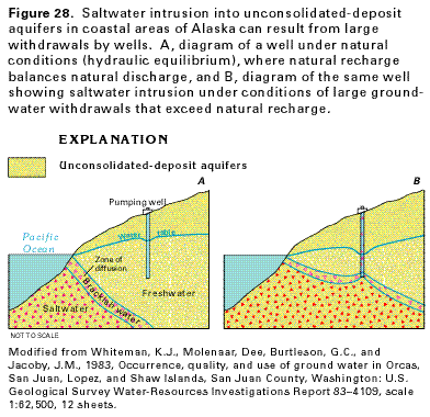
Freshwater in some of the sand and gravel beds of the coastal valley aquifer near Juneau and in the Mendenhall Valley is hydraulically connected to saltwater bodies (fig. 26). Under natural conditions, saltwater in the parts of the aquifer beneath Fritz Cove and Gastineau Channel is in balance with freshwater in the inland parts of the aquifer, a condition known as hydraulic equilibrium. If the freshwater column inland is lowered as a result of withdrawal by wells, however, the saltwater can migrate inland, contaminate some of the freshwater in the aquifer, and render it unfit for use.
The hydraulic conditions that are likely to result in saltwater intrustion are summarized in figure 28. Under natural conditions, saltwater in the offshore parts of an unconsolidated-deposit aquifer is balanced by a thicker column of freshwater onshore (fig. 28A). Large withdrawals from wells completed in the freshwater parts of the aquifer cause the water table to decline and the thickness of the freshwater column to decrease (fig. 28B). The equilibrium between the saltwater and freshwater is, thus, imbalanced, and saltwater moves inland. Eventually, the saltwater might enter the pumping wells and contaminate the water to the extent that it is unsuitable for most uses.