INTRODUCTION
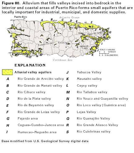
River alluvium that fills bedrock valleys located in the interior and coastal areas of Puerto Rico (fig. 80) forms small aquifers that are locally important sources of water for industrial, municipal, and domestic supplies. The aquifers, which characteristically fill valleys incised into volcaniclastic, igneous intrusive, or limestone bedrock, generally are less than 110 to 150 square miles in area and extend over less than 50 percent of their respective drainage basins. They typically supply less than 15 percent of the total water used in the drainage basin.
Most of the alluvial valley aquifers are located in the generally flat-lying coastal areas of streams that originate on the steep-sided Cordillera Central and other mountain ranges. The seaward extent of these aquifers is bounded in the subsurface by a freshwater-saltwater interface and on the surface by brackish-water wetlands or lagoons. The maximum thickness of the aquifers is about 270 feet on the east coast, 300 feet on the west coast, 300 feet on the north coast, and about 150 feet on the southwestern coast. In the Caguas-Gurabo-Juncos area of the east-central interior (fig. 80), the aquifers are less than 150 feet thick. Aquifer materials are predominantly sand and gravel interlayered with clay and silt.
The natural chemical quality of water in the alluvial valley aquifers generally is suitable for most uses. However, excessive concentrations of dissolved iron and manganese are a problem in the east coast area. Contamination of the aquifers by pollutants that result from human activities is a universal concern because of the high population density.
Although each alluvial aquifer is unique in dimension, hydraulic characteristics, hydrogeology, and water quality, the aquifers generally share a similar setting, origin, composition, and hydrologic character. Thus, because they are too numerous to describe in detail, the aquifer in the Humacao-Naguabo area (I on fig. 80) is presented as a characteristic example of the alluvial valley aquifers.
GENERAL SETTING
The Humacao-Naguabo area, which is made up of six distinct
drainage basins that total about 90 square miles in area, is located
in the southeastern part of the east coast of Puerto Rico (fig. 80). The principal streams that drain
the area are the Río Humacao and the Río Blanco
(fig. 81), which originate in the eastern foothills of the Sierra
de Cayey and the Sierra de Luquillo, respectively. The drainage
basins are divided by sharp, steeply sloping ridges that range
in altitude from 300 to 500 feet above mean sea level.
The alluvial valley aquifer, which extends over approximately 40 percent of the area of the drainage basins, is widest in the broad, flat valley floor near the coast and extends up the river valleys (fig. 81). The top of the alluvium ranges in altitude from sea level to about 160 feet above mean sea level. A mangrove swamp is present along the mouth of the Río Antón Ruiz, and two brackish-water lagoons are in depressions along the coast.
The Humacao-Naguabo area recently has undergone rapid development of light industry that has contributed to a significant population growth and placed large demands on local water supplies. Most of the demand (93 percent) has been met from surface-water sources. Total freshwater use in the area during 1985 was 14.6 million gallons per day, of which fresh ground-water withdrawals were only 0.93 million gallons per day.
GEOLOGY
Extensively faulted and fractured volcaniclastic rocks of Cretaceous
age and intrusive igneous rocks of Tertiary age underlie the alluvial
aquifer (fig. 81). The plutonic rocks
consist mostly of granodiorite and quartz diorite; the volcanic
rocks are a mixture of sandstone, conglomerate, tuff, breccia,
and andesitic lava flows. A weathered zone is characteristically
developed on the bedrock. The thickness of this zone is 20 feet
or more under the alluvial deposits and as much as 40 feet in
bedrock outcrop areas. Where it is covered by alluvium, the weathered
zone forms part of the aquifer. Alluvium-filled valleys, which
were eroded into the bedrock along fault traces at a time when
sea level was much lower than at present, underlie the principal
streams. The bedrock valley near the Río Humacao is incised
to a depth of about 160 feet below mean sea level at the coast
but is less deeply incised inland. Thus, the aquifer, which consists
of poorly sorted sand, silt, and clay, forms a wedge that ranges
from about 160 feet thick at the coast to a featheredge inland.
HYDROLOGY
The alluvial valley aquifer consists of unconsolidated alluvium
and the weathered part of the underlying bedrock. The aquifer
is unconfined and is hydraulically connected to streams. In most
places, water moves readily from the aquifer to the streams to
sustain base flow. The depth to the water table in the alluvium
ranges from 50 to 60 feet in inland areas to less than 5 feet
in coastal areas.
Water enters the aquifer as recharge from multiple sources and reemerges from the aquifer through several avenues of discharge. Some recharge is from the infiltration of part of the precipitation that falls on the surface of the alluvium. Runoff of precipitation that falls on the almost impermeable bedrock hills infiltrates the aquifer at the bedrock/alluvium contact and also provides some recharge. Recharge also is by inflow of water from streams that flow onto the alluvium from bedrock areas in the upstream parts of drainage basins. Streams recharge the aquifer principally in upstream areas as they cross the alluvium, where stream levels are higher than water levels in the aquifer. The aquifer discharges by seepage to streams, wetlands, and lagoons; by withdrawals from wells; by evapotranspiration in areas where the water table is very shallow; and by seepage to the ocean.
The water table in the alluvial aquifer slopes seaward from an altitude of about 80 to 100 feet above sea level in the upstream part of each of the valleys to sea level at the coast (fig. 82). Thus, the hydraulic gradient is seaward and ground-water movement generally is toward the sea. However, in each of the drainage basins, ground-water movement in the upstream parts of the alluvial aquifer is toward the streams where the water is discharged. In the downstream parts of the aquifer, flow is seaward, and discharge is to coastal wetlands, lagoons, and the sea.
Concurrent measurements of streamflow at a number of sites along the Río Humacao during low-flow conditions (fig. 82; table 5) demonstrate the interchange of water between the stream and the alluvial aquifer. A comparison of measurements at the gaging stations (table 5) shows an alternating pattern of losses and gains; principal losses were between sites 1 and 2 where the stream loses water to the aquifer as it flows from its up-basin bedrock channel onto the alluvium and at sites 14 to 17 in the lower reaches of the stream. A principal gaining reach is midstream between sites 9 and 12, where water enters the stream from the aquifer. The water moves to or from the stream along its course in response to the relative altitudes of the water table in the aquifer and the stream surface. Where the water level in the aquifer is higher than that in the stream, water moves from the aquifer to the stream; movement is reversed where the relative altitudes of the stream surface and water table are reversed.
The exchange of water between a stream and the alluvial aquifer can change as hydrologic conditions change (fig. 83). Throughout most of the year, the water table is higher in Arroyo well 1, which is near the Río Blanco (fig. 82), than the water level in the stream, and water moves from the aquifer to the stream. However, during periods of intense rainfall, as indicated by sharp peaks on the graph in figure 83, the stream level and the water table rise. In some instances (for example, early November 1983 and early June 1984), the stream level rises until it is temporarily higher than the water table. Under these conditions, the normal direction of water movement is reversed, and water moves into the aquifer from the stream. Note that ground-water levels in this area fluctuate as much as 8 feet and that stream levels fluctuate as much as 12 feet (fig. 83).
A freshwater-saltwater interface is present at the coast in
the upper part of the alluvial aquifer. In the deeper parts of
the aquifer, the interface extends inland as a wedge-shaped body
of saltwater. The approximate position of the interface in March
1984 is shown in figure 84A. The interface
is maintained because of the difference in the density of freshwater
and saltwater. Because the freshwater is lighter, a 41-foot column
of freshwater is necessary to balance a 40-foot column of seawater.
As a result, for each foot of freshwater above sea level, there
is a 40-foot column of freshwater below sea level. Under natural
(March 1984) conditions, fresh ground water moves toward and up
the sloping interface to discharge to the sea floor. The position
of the interface is maintained by an equilibrium of freshwater
flow toward the sea and saltwater flow toward the land. Saltwater
movement is constant because of constant sea level; however, excessive
ground-water withdrawals would lower the column of freshwater,
reduce freshwater flow, and cause the interface to move landward
(fig. 84B), thus contaminating the
aquifer with saltwater. Progressive landward migration of the
interface would occur if successively larger quantities of water
are withdrawn from the aquifer. If withdrawals in the Río
Humacao Valley were increased 0.72 million
gallons per day beyond 1984 withdrawals (fig.
84C), computer simulation indicates that excessive saltwater
encroachment would occur. If 1984 withdrawals were increased by
1.08 million gallons per day, simulation indicates that saltwater
would occupy almost all of the aquifer (fig.
84D).
HYDRAULIC PROPERTIES
The availability of ground water depends on the ability of an
aquifer to store, transmit, and release water to wells; this ability
can be described by the hydraulic properties of the aquifer. Transmissivity
is a measure of the ability of an aquifer to transmit water. The
greater the transmissivity, the more water the aquifer can yield.
The storage coefficient of an aquifer is a measure of the volume
of water an aquifer can release from or take into storage per
unit surface area per unit change in hydraulic head. Transmissivity
values determined from aquifer tests of the alluvial valley aquifer
in the Humacao-Naguabo area range from 200 to 2,000 feet squared
per day, which are relatively low values. The storage coefficient
of the aquifer is about 0.02, which is a low value for an unconfined
aquifer. With these hydraulic properties, well yields are not
expected to be more than 30 to 100 gallons per minute.
GROUND-WATER QUALITY
The natural quality of ground water in the alluvial valley aquifer
in the Humacao-Naguabo area was determined by analysis for common
anions, cations, trace metals, and properties in water samples
collected from 19 wells (table 6). Dissolved-solids concentrations
in 10 of the 19 samples exceeded 500 milligrams per liter and
were as large as 4,274 milligrams per liter. Iron and manganese
concentrations were similarly elevated in a number of samples;
iron exceeded 0.3 milligram per liter in 10 samples and manganese
exceeded 0.2 milligram per liter in 8 samples. Other properties
and ion concentrations generally are within the normal range of
values for a water-table aquifer in alluvial deposits, except
for sodium and chloride. Sodium and chloride concentrations were
large in water from two areas near the coast-in the vicinity of
the coastal mangrove swamps at the mouth of the Río Antón
Ruiz and the Río Blanco, and at the mouth of the Río
Candelero (fig. 85). The large concentrations
are probably due to seawater contamination of the aquifer, which
apparently results from the seepage of seawater into the aquifer
from large tidal fluctuations in coastal areas. Fresh ground-water
withdrawals have not caused saltwater intrusion into the aquifer.
The large average concentrations of sodium and chloride in the 19 water samples (table 6) result from a few samples that have very large concentrations of these ions. Water in the alluvial valley aquifer, where unaffected by saltwater, generally can be characterized as very hard and as a calcium magnesium bicarbonate type with excessive local concentrations of iron and manganese.
FRESH GROUND-WATER WITHDRAWALS
Fresh ground-water withdrawals from alluvial aquifers throughout
Puerto Rico during 1985 were about 24 million gallons per day,
or nearly 14 percent of the total ground water withdrawn on the
island. Withdrawals from the alluvial valley aquifer in the Humacao-Naguabo
area were 0.93 million gallons per day during 1985. Only one public
supply well withdrew water from the aquifer in 1985; nine other
public supply wells were abandoned because of excessive concentrations
of iron and manganese. Many wells that withdraw water for other
uses have been abandoned for similar reasons. Although many industrial
wells have been constructed, the well yields are often inadequate
and the industries continue to depend largely on public supply
systems for water.
Nearly 68 percent of the ground water withdrawn in the Humacao-Naguabo area was used for industrial supply during 1985 (fig. 86). The remaining withdrawals were roughly equally divided between public-supply, domestic, and agricultural uses. No water was withdrawn for commercial, mining, or thermoelectric power uses.