INTRODUCTION
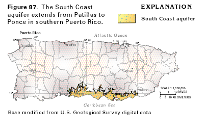
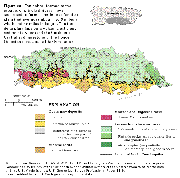
The South Coast aquifer is an alluvial aquifer that underlies the broad coastal plain that extends from Patillas westward to Ponce in southern Puerto Rico (fig. 87). The aquifer averages about 4 to 5 miles in width and extends east-west for about 40 miles. The alluvium that composes the aquifer was deposited mostly in a number of coalescing fan-deltas that built seaward from the mouths of major streams (fig. 88).
The south coastal plain of Puerto Rico is, and historically has been, an important agricultural area and in recent years has been a growing industrial area. Irrigation structures, including an extensive network of canals and reservoirs, were constructed as early as the late 1800's between the Río Jacaquas and Ponce, and smaller structures for diversion of base flow of streams were built in the areas of Santa Isabel, Salinas, and Guayama. In 1914 the first large-scale surface-water irrigation system was completed and included the Canal de Patillas and the Lago Patillas reservoir, the Lago Carite reservoir in the Río de la Plata watershed north of the island's principal surface-water divide and diversion tunnel to the Río Guamaní, the Canal de Juana Díaz, and the Lago Guayabal and Lago Coamo reservoirs. With the completion of the Lago El Guineo and Lago de Matrullas reservoirs in the Río Grande de Manatí watershed north of the principal divide and a diversion tunnel to Río Jacaquas, the system of reservoirs, tunnels, pump stations, and canals conveyed an average of 123 cubic feet per second by 1935.
Ground-water development began in the coastal plain in about 1910 with the construction of wells furnished with steam-operated pumps powered by kerosene. The use of ground water for irrigation expanded greatly in the 1930's with the extension of electrification, installation of generators at several sugar mills, and introduction of deep-well turbine pumps. Large-scale dewatering works were also constructed during the late 1930's to control the spread of malaria and to reclaim additional land for sugar cane cultivation.
The canal network is supplied by surface water and has augmented recharge to the aquifer. Consequently, aquifer discharge, which mainly occurs as ground-water withdrawals and as seepage to local streams and to the sea, has increased. During 1982, water deliveries, used largely for growing sugar cane, were about 40 cubic feet per second through the government-operated irrigation canal network east of Río Jacaquas and about 20 cubic feet per second through a private network west of the river. Total ground-water withdrawals during 1980 averaged approximately 86 cubic feet per second; 62 percent of the water withdrawn was used for irrigation and the remainder was used for public supply.
Water movement through the part of the aquifer from Salinas to Patillas prior to development was estimated to be 43 cubic feet per second. During full development of the canal system in the 1950's and 1960's, water movement in the aquifer in the Salinas to Patillas area increased to an estimated 126 cubic feet per second. With a reduction in sugar production and conversion to a drip irrigation system, there was a reduction of water delivered by the canal system. The amount of water movement in the aquifer during 1986 was estimated to be only about 88 cubic feet per second.
HYDROGEOLOGY
The South Coast aquifer consists of alluvial and fan-delta deposits
derived from erosion of the volcanic and sedimentary rocks of
the Cordillera Central. The alluvium was transported and deposited
by numerous steep-gradient, high-energy, south-flowing streams
that originate at altitudes above 1,000 feet within 15 to 20 miles
of the coast (fig. 88). The alluvial
deposits below an altitude of 100 to 150 feet are of Holocene
age. Above this altitude and extending to the bedrock foothills,
the deposits are of Holocene and Pleistocene (?) age, and erosional
terraces have developed on them.
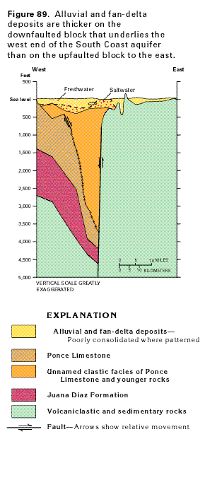
Fan-deltas and alluvial deposits rest on a south-sloping bedrock shelf that has been subject to subaerial erosion and is extensively faulted in a horst and graben, or block-fault, pattern. East of Salinas, the bedrock surface is relatively smooth and alluvial deposits range in thickness from about 90 to 150 feet near the coast to about 250 feet where bedrock is more deeply incised or downfaulted. West of Salinas to Ponce, the alluvium ranges in thickness from about 100 to more than 1,000 feet near the coast. An oil-test well drilled near Santa Isabel is reported to have penetrated more than 2,500 feet of unconsolidated and poorly consolidated Pliocene (?) to Miocene clastic deposits which underlie Quaternary deposits and might indicate a deep basin formed by a graben structure in the bedrock.
Bedrock that underlies the coastal plain consists principally of volcaniclastic and sedimentary rocks of Tertiary and Cretaceous age in areas east of Salinas and sedimentary rocks of Tertiary age in areas west of Salinas (fig. 88). The Tertiary sedimentary rocks consist of the Juana Díaz Formation of Oligocene and Miocene age, which overlies the volcaniclastic and sedimentary rocks, and the Ponce Limestone of Miocene and Pliocene age, which overlies the Juana Díaz Formation. The Juana Díaz Formation and Ponce Limestone are in fault contact with older volcaniclastic and sedimentary rocks in places (fig. 89).
The volcaniclastic and sedimentary rocks consist of massive to thick bedded andesitic tuff, welded tuff, porphyritic basalt, volcanic breccia, sandstone, and siltstone. The Juana Díaz Formation consists of thin-bedded sandy to shaly, fossiliferous limestone interbedded with marl, shale, and conglomerate. The Ponce Limestone unconformably overlies the Juana Díaz Formation and consists of a shallow-marine, fossiliferous limestone that grades to clastic facies in subsurface areas to the east (fig. 89). Total thickness of the formation is uncertain but may exceed 1,000 feet.
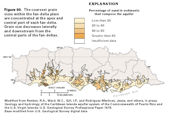
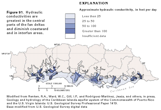
The alluvial material that makes up the South Coast aquifer was largely deposited as a series of fan-deltas (fig. 88), each heading at a stream channel incised into bedrock and some widening downstream to coalesce with neighboring fans from adjacent channels. The downstream parts of the fan- deltas were deposited in the sea. The result is a broad alluvial plain that gently slopes and thickens southward to the Caribbean Sea. The method of deposition of the alluvial sediments has imposed a characteristic grain-size distribution within the alluvium that is significant hydrologically. The coarsest sediments (sand and gravel) were deposited as the streams emerged from their incised channels onto the alluvial plain. Sediment grain size decreases to silt and clay both laterally at the coalescing edges of adjoining fan-deltas and seaward; thus, the percentage of coarse sediment is greatest near the central part of the fan where the streams first diverged and spread out across the coastal plain (fig. 90).
The areas of greatest hydraulic conductivity (fig. 91) coincide with areas where the percentage of sand and gravel is highest. Hydraulic conductivity is a measure of the rate at which water will pass through an aquifer; the greater the hydraulic conductivity, the more water the aquifer will yield to wells. Hydraulic conductivities are highest in plume-shaped areas that head at major stream channels, and diminish laterally and in a downstream direction (fig. 91).
GROUND-WATER FLOW
Ground water in the alluvial deposits generally is under water-table
(unconfined) conditions, except in some areas near the coast where
silt or clay beds locally create confined conditions. A freshwater-saltwater
interface is assumed to be present near the coast in the alluvial
sediments, but the thickness of the freshwater zone generally
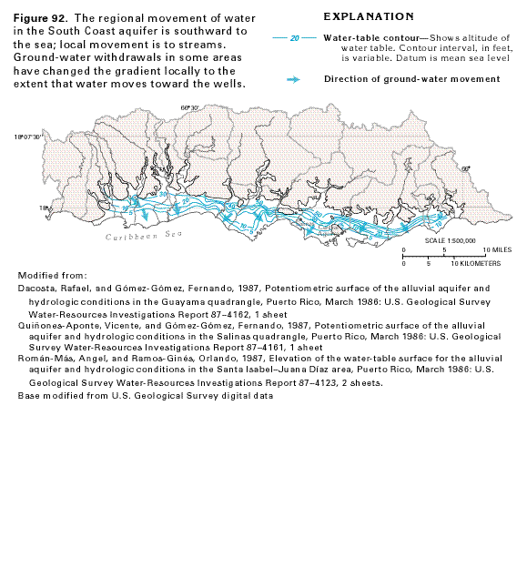
is poorly known. The water table generally slopes southward from
the foothills to the Caribbean Sea (fig.
92).
Before development, regional ground-water movement was from recharge areas southward to the coast; locally, some water moved laterally to major streams, mostly in downstream reaches. Recharge to the aquifer was from infiltration of precipitation that fell directly on the alluvium and from streamflow seepage. Discharge was to streams and the sea and as direct evapotranspiration from the aquifer where the water table was shallow. The long history of construction of drainage ditches and irrigation canals and withdrawal of ground water in this agricultural and industrial area, however, has greatly altered natural ground-water flow. Recharge has been augmented by seepage of surface water transported in the several irrigation canals that cross the alluvium and from the practice of furrow irrigation. During 1985, irrigation deliveries from the canal network operated by the government were approximately 60 million gallons per day, of which an estimated 30 percent recharged the aquifer. Although most ground water moves toward the sea and locally to streams (fig. 92), development has partially altered the direction of flow. For example, some water moves toward well fields, such as the one just north of Central Aguirre near Salinas. Discharge from the aquifer is mainly as ground-water withdrawals; withdrawals during 1985 were about 74 million gallons per day.
GROUND-WATER QUALITY
The natural chemical quality of water in the South Coast aquifer
has changed greatly as a result of human activities during the
last century. Surface water collected in reservoirs in the mountains
and channeled into an extensive canal and furrow irrigation network
has seeped downward into the aquifer and altered the chemical
quality of the ground water. In addition, the intensive use of
the coastal plain for the cultivation of sugar cane throughout
most of the twentieth century required the use of fertilizers
(generally a calcium sulfate substance) and lime (calcium carbonate)
to reclaim saline soils. The direction of predevelopment ground-water
movement also has been changed by large-scale withdrawals. Locally,
these changes in the flow system have moved and mixed waters of
different chemical qualities within the aquifer.
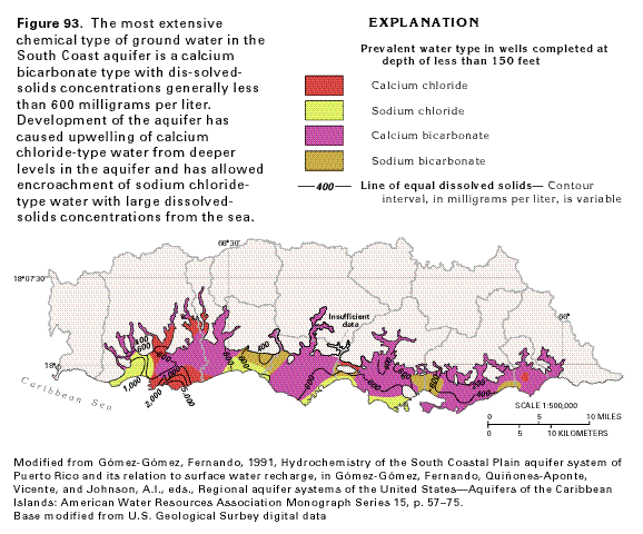
Prior to development of the aquifer, water in the South Coast aquifer was probably a calcium bicarbonate type (fig. 93) with dissolved-solids concentrations generally less than 600 milligrams per liter. Most of the water in the aquifer is still of that chemical type. However, it appears that near the western end of the aquifer the water is undergoing a major chemical change due to withdrawals, capture of streamflow by wells situated inland, and possibly a decrease in recharge. The calcium bicarbonate-type water is being replaced by water moving upward from a deeper level in the aquifer. The deeper water contains larger concentrations of dissolved solids and is a calcium chloride type, possibly because meteoric water enters the aquifer at the higher parts of the alluvial plain where the alluvium is underlain by limestone. Sodium chloride-type water from seawater encroachment is replacing calcium chloride- type water adjacent to the coast at the extreme western end of the coastal plain. Sodium bicarbonate-type water in inter-fluvial areas may result from a high percentage of sodium-rich clay, silt, and volcanic rock particles in the alluvium that composes the aquifer in these areas.
FRESH GROUND-WATER WITHDRAWALS
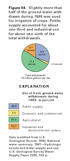
Total fresh ground-water withdrawals from the South Coast aquifer
were about 74 million gallons per day during 1985 (fig.
94). Slightly more than one-half the water withdrawn, or about
38 million gallons per day, was used for agriculture, primarily
irrigation of crops. The other principal use was for public supply,
which amounted to about 31 percent of total withdrawals, or about
23 million gallons per day. About 16 percent, or about 12 million
gallons per day, was withdrawn for industrial use. Domestic and
commercial withdrawals were 2.4 percent, or about 2 million gallons
per day. Thermoelectric power production accounted for the withdrawal
of only a small amount of water. No water was withdrawn for mining.
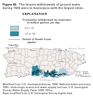
During 1985, most of the water withdrawn was distributed in those municipios with the largest cities (fig. 95). Withdrawals in each of the municipos of Ponce, Santa Isabel, and Salinas, together with agricultural withdrawals, exceeded 15 million gallons per day.