U.S. Geological Survey Miscellaneous Investigations Map I–2362
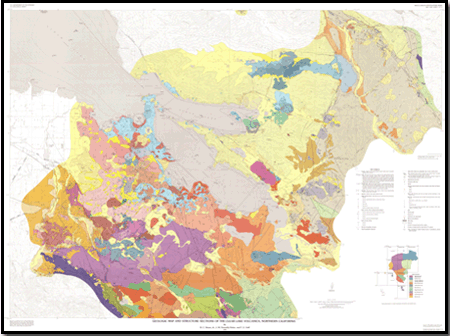
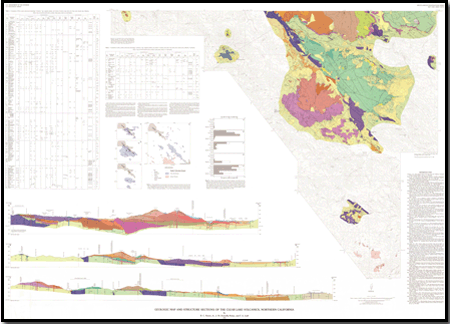
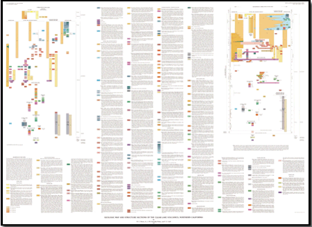
SummaryThe Clear Lake Volcanics are located in the California Coast Ranges about 150 km north of San Francisco. This Quaternary volcanic field has erupted intermittently since 2.1 million years ago. This volcanic field is considered a high-threat volcanic system (Ewert and others, 2005) The adjacent Geysers geothermal field, largest power-producing geothermal field in the world, is powered by the magmatic heat source for the volcanic field. This report consists of three sheets that include the geologic map, one table, two figures, three cross sections, description of map units, charts of standard and diagrammatic correlation of map units, and references. This map supersedes U.S. Geological Survey Open-File Report 76-751. Descriptions of map units are grouped by geographic area. Summaries of the evolution, chemistry, structure, and tectonic setting of the Clear Lake Volcanics are given in Hearn and others (1981) and Donnelly-Nolan and others (1981). The geology of parts of the area underlain by the Cache Formation is based on mapping by Rymer (1981); the geology of parts of the areas underlain by the Sonoma Volcanics, Franciscan assemblage, and Great Valley sequence is based on mapping by McLaughlin (1978). Volcanic compositional map units are basalt, basaltic andesite, andesite, dacite, rhyodacite, and rhyolite, based on SiO2 content. Included in this report are maps showing the distribution of volcanic rocks through time and a chart showing erupted volumes of different lava types through time. A table gives petrographic data for each map unit by mineral type, abundance, and size. Most ages are potassium-argon (K/Ar) ages determined for whole-rock samples and mineral separates by Donnelly-Nolan and others (1981), unless otherwise noted. A few ages are carbon-14 ages or were estimated from geologic relationships. Magnetic polarities are from Mankinen and others (1978; 1981) or were determined in the field by B.C. Hearn, Jr., using a portable fluxgate magnetometer. Thickness for most units is estimated from topographic relief except where drill-hole data were available.
|
Standard resolution
Print resolution
Contact Information
Volcano Science Center - Menlo Park U.S. Geological Survey 345 Middlefield Road, MS 910 Menlo Park, CA 94025 http://volcanoes.usgs.gov/ This report is presented in Portable Document Format (PDF); the latest version of Adobe Reader or similar software is required to view it. Download the latest version of Adobe Reader, free of charge. |
Hearn, B.C., Jr., Donnelly-Nolan, J.M., and Goff, F.E., 1995, Geologic map and structure sections of the Clear Lake Volcanics, northern California: U.S. Geological Survey Miscellaneous Investigations Map I–2362, 3 sheets, scale 1:24,000, available at https://pubs.usgs.gov/imap/2362/.

![]() U.S. Department of the Interior |
U.S. Geological Survey
U.S. Department of the Interior |
U.S. Geological Survey
URL: http://pubsdata.usgs.gov/pubs/imap/2362/index.html
Page Contact Information: GS Pubs Web Contact
Page Last Modified: Wednesday, 19-Aug-2020 15:34:46 EDT