Geologic Investigations Map I-2800: This Dynamic Planet
Third Edition (Published 2006)
Cartography and graphic design by Will R. Stettner,2 with contributions by Antonio Villaseñor,4 and edited by Katharine S. Schindler2
1Smithsonian Institution, 2U.S. Geological Survey, 3U.S. Naval Research Laboratory, 4Institute of Earth Sciences Jaume Almera, Spanish National Research Council
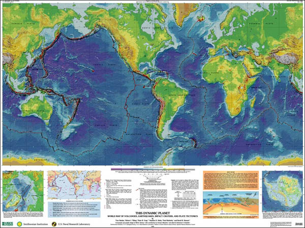
Our Earth is a dynamic planet, as clearly illustrated on the main map by its topography, over 1,500 volcanoes, 44,000 earthquakes, and 170 impact craters. These features largely reflect the movements of Earths major tectonic plates and many smaller plates or fragments of plates (including microplates). Volcanic eruptions and earthquakes are awe-inspiring displays of the powerful forces of nature and can be extraordinarily destructive. On average, about 60 of Earth's 550 historically active volcanoes are in eruption each year. In 2004 alone, over 160 earthquakes were magnitude 6.0 or above, some of which caused casualties and substantial damage.
This map shows many of the features that have shaped--and continue to change--our dynamic planet. Most new crust forms at ocean ridge crests, is carried slowly away by plate movement, and is ultimately recycled deep into the Earth--causing earthquakes and volcanism along the boundaries between moving tectonic plates. Oceans are continually opening (for example, Red Sea, Atlantic Ocean) or closing (for example, Mediterranean Sea). Because continental crust is thicker and less dense than thinner, younger oceanic crust, most does not sink deep enough to be recycled, and remains largely preserved on land. Consequently, most continental bedrock is far older than the oldest oceanic bedrock (see back of map).
The earthquakes and volcanoes that mark plate boundaries are clearly shown on this map, as are craters made by impacts of extraterrestrial objects that punctuate Earth's history, some causing catastrophic ecological changes. Over geologic time, continuing plate movements, together with relentless erosion and redeposition of material, mask or obliterate traces of earlier plate-tectonic or impact processes, making the older chapters of Earth's 4,500-million-year history increasingly difficult to read. The recent activity shown on this map provides only a present-day snapshot of Earth's long history, helping to illustrate how its present surface came to be.
The map is designed to show the most prominent features when viewed from a distance, and more detailed features upon closer inspection. The back of the map zooms in further, highlighting examples of fundamental features, while providing text, timelines, references, and other resources to enhance understanding of this dynamic planet. Both the front and back of this map illustrate the enormous recent growth in our knowledge of planet Earth. Yet, much remains unknown, particularly about the processes operating below the ever-shifting plates and the detailed geological history during all but the most recent stage of Earth's development.
In addition to the paper map, which is available for purchase, the USGS is providing PDF files of the map. These files are very large and should be downloaded and viewed in Adobe Reader.
Below: Thumbnail image of the front of the map, which measures 58 by 45 inches, and a figure representative of the materials on the reverse side of the map.
The two-sided map can be ordered from the USGS Store. On the Map Locator page, enter "This Dynamic Planet" into the Product Name box. A single handling fee is applied to all domestic orders. For international shipping, see the USGS frequently asked questions page. Discounts are available for some groups. For more information call 1-888-ASK-USGS.
The map is also for sale from:
U.S. Geological Survey
Information Services
Box 25286, Federal Center
Denver, CO 80225
New product number 206335.
Please visit the Smithsonian Institution This Dynamic Planet website. This site provides interactive mapping functions (including zoom), contains additional information not shown on the printed paper map, and includes downloadable PDF files of all map components and HTML pages.
See also the USGS booklet This Dynamic Earth: The Story of Plate Tectonics, which gives background information about the theory of plate tectonics and traces its development.
The USGS also has created a website for teachers: This Dynamic Planet: A Teaching Companion.
Any use of trade, product, or firm names in this publication is for descriptive purposes only and does not imply endorsement by the U.S. Government.

![]() U.S. Department of the Interior |
U.S. Geological Survey
U.S. Department of the Interior |
U.S. Geological Survey
URL: pubsdata.usgs.gov /pubs/imap/2800/index.html
Page Contact Information: Katharine S. Schindler
Page Last Modified: Wednesday, 30-Nov-2016 17:39:05 EST