U.S. Geological Survey Geologic Investigations Series I-856-H |
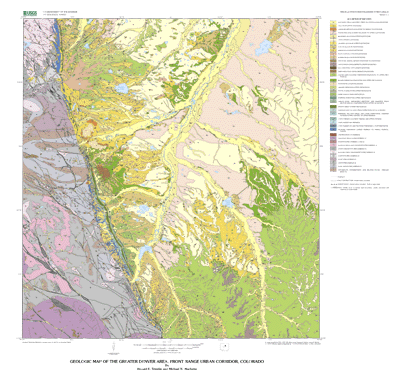
Geologic Map of the Greater Denver Area, Front Range Urban Corridor, Colorado |
By Donald E. Trimble and Michael N. Machette |
Version 1.1 |
 |
| The text of this report is presented here in Portable Document Format. The latest version of Adobe Acrobat Reader® or similar software is required to view it. If you wish to download the latest version of Acrobat Reader® free of charge, click here. |
| I-856-H v1.0 PDF file (86.3 MB) | Print optimized scan of the original printed map **Large File Warning!** |
|
For advice on how to download large files to your hard drive, click here. |
| |
| I-856-H v1.1 PDF file (8.4 MB) | Plot of the current dataset |
| |
| Text-only PDF file (1.21 MB) | (This version of the report is accessible as defined in Section 508.) |
| |
| I-856-H MET file (120 KB) | Metadata file |
For a full description of map units and base map themes, please see: |
|
| OFR-03-025: | A Spatial Database of Bedding Attitudes to Accompany Geologic Map of the Greater Denver Area, Front Range Urban Corridor, Colorado |
Download ArcInfo export, ArcView shapefile, and associated files |
| I-856-H TAR.GZ file (29.3 MB) |
| I-856-H ZIP file (29.3 MB) |
| A high-quality printed edition of this publication is for sale by Information Services, U.S. Geological Survey (1-888-ASK-USGS). |
| AccessibilityFOIAPrivacyPolicies and Notices | |
| |
|