U.S. Geological Survey Geologic Investigations Series I–2686
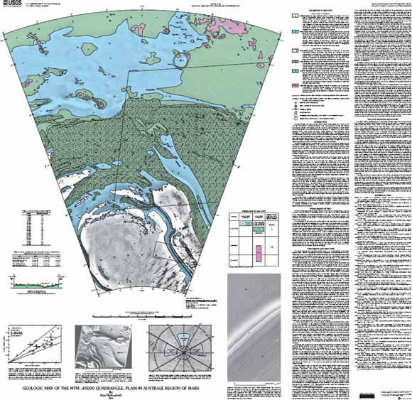
The polar deposits on Mars probably record martian climate history over the last 107 to 109 years (for example, Thomas and others, 1992). The area shown on this map includes layered polar deposits and residual polar ice, as well as some exposures of older terrain. Howard and others (1982) noted that an area (at lat 84.8° S., long 356° W.) near a 23-km diameter impact crater (Plaut and others, 1988) appears to have undergone recent deposition, as evidenced by the partial burial of secondary craters. Herkenhoff and Murray (1990a) mapped this area as a mixture of frost and defrosted ground and suggested that the presence of frost throughout the year stabilizes dust deposited in this area. This quadrangle was mapped using high-resolution Mariner 9 (table 1) and Viking Orbiter images in order to study the relations among erosional, cratering, and depositional processes on the polar layered deposits and to search for further evidence of recent deposition.
Published geologic maps of the south polar region of Mars are based on images acquired by Mariner 9 (Condit and Soderblom, 1978; Scott and Carr, 1978) and the Viking Orbiters (Tanaka and Scott, 1987). The extent of the layered deposits mapped previously from Mariner 9 data is different from that mapped using Viking Orbiter images, and the present map agrees with the map by Tanaka and Scott (1987): the layered deposits extend to the northern boundary of the map area. However, the oldest unit in this area is mapped as undivided material (unit HNu) rather than the hilly unit in the plateau sequence (unit Nplh; Tanaka and Scott, 1987).
The residual polar ice cap, areas of partial frost cover, the layered deposits, and two nonvolatile surface units—the dust mantle and the dark material—were mapped by Herkenhoff and Murray (1990a) at 1:2,000,000 scale using a color mosaic of Viking Orbiter images. This mosaic was used to confirm the identification of the non-volatile Amazonian units for this map and to test hypotheses for their origin and evolution. The colors and albedos of these units, as measured in places both within and outside of this map area, are presented in table 2 and figure 1. The red/violet ratio image was particularly useful in distinguishing the various low-albedo materials, as brightness variations due to topography are essentially removed in such ratio images and color variations are easily seen. Because the resolution of the color mosaics is not sufficient to map these units in detail at 1:500,000 scale, contacts between them were recognized and mapped using higher resolution black and white Viking and Mariner 9 images.
The largest impact crater in the layered deposits, 23 km in diameter at lat 84.5° S., long 359° W., now named "McMurdo," was recognized by Plaut and others (1988). The northern rim of this crater is missing, perhaps due to erosion of the layered deposits in which it was formed (fig. 2). Secondary craters from this impact are not observed north of the crater but are abundant to the south. Although the crater statistics are poor (only 16 likely impact craters found in Viking Orbiter images of the south polar layered deposits), these observations generally support the conclusions that the south polar layered deposits are Late Amazonian in age and that some areas have been exposed for about 120 million years (Plaut and others, 1988; Herkenhoff and Murray, 1992, 1994; Herkenhoff, 1998). However, the recent cratering flux on Mars is poorly constrained, so inferred ages of surface units are uncertain.
The Viking Orbiter 2 images used to construct the base were taken during the southern summer of 1977, with resolutions no better than 130 m/pixel. A digital mosaic of Mariner 9 images also was constructed to aid in mapping. The Mariner 9 images were taken during the southern summer of 1971 and 1972 and have resolutions as high as 85 m/pixel (table 1). However, the usefulness of the Mariner 9 mosaic image is limited by incomplete coverage and high levels of atmospheric dust opacity.
Last modified March 21, 2012
First posted January 8, 2004
For additional information:
Contact Astrogeology Research Program staff
Astrogeology Science Center
U.S. Geological Survey
2255 N. Gemini Dr.
Flagstaff, AZ 86001
http://astrogeology.usgs.gov/
This report is presented in Portable Document Format (PDF); the latest version of Adobe Reader or similar software is required to view it. Download the latest version of Adobe Reader, free of charge.
Herkenhoff, Ken, 2001, Geologic map of the MTM–85000 quadrangle, Planum Australe region of Mars: U.S. Geological Survey Geologic Investigations Series I–2686, available at https://pubs.usgs.gov/imap/i2686/.

![]() U.S. Department of the Interior |
U.S. Geological Survey
U.S. Department of the Interior |
U.S. Geological Survey
URL: http://pubsdata.usgs.gov/pubs/imap/i2686/index.html
Page Contact Information: GS Pubs Web Contact
Page Last Modified: Wednesday, 30-Nov-2016 17:36:26 EST
