Link to USGS home page


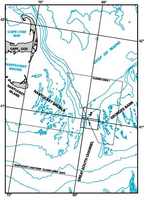
Maps Showing Sea Floor Topography, Sun-Illuminated
Sea Floor Topography, and Backscatter Intensity of
Quadrangles 1 and 2 in the Great South Channel Region,
Western Georges Bank

Page C. Valentine, editor

U.S. GEOLOGICAL SURVEY GEOLOGIC INVESTIGATIONS SERIES MAP I–2698

2002, Version 1.0

Prepared in cooperation with the National Oceanic and Atmospheric Administration


INDEX – LINKS TO FILES ON THIS CD-ROM


HTML file of methods

   • Methods of Acquiring and Displaying
     Sea Floor Data

HTML files of discussions printed on the map sheets

   • Sheet A—Sea Floor Topography of
     Quadrangle 1
   • Sheet B—Sun-Illuminated Sea Floor
     Topography of Quadrangle 1
   • Sheet C—Sea Floor Topography of
     Quadrangle 2
   • Sheet D—Sun-Illuminated Sea Floor
     Topography of Quadrangle 2
   • Sheet E—Backscatter Intensity and
     Sun-Illuminated Sea Floor Topography
     of Quadrangles 1 and 2

PS files of the map sheets
(to download for printing)

   
• Sea Floor Topography of Quadrangle 1
   • Sun-Illuminated Sea Floor Topography
     of Quadrangle 1
   • Sea Floor Topography of Quadrangle 2
   • Sun-Illuminated Sea Floor Topography
     of Quadrangle 2
   • Backscatter Intensity and
     Sun-Illuminated Sea Floor Topography
     of Quadrangles 1 and 2

EPS files of the map sheets
(to download for printing)

   • Sea Floor Topography of Quadrangle 1
   • Sun-Illuminated Sea Floor Topography
     of Quadrangle 1
   • Sea Floor Topography of Quadrangle 2
   • Sun-Illuminated Sea Floor Topography
     of Quadrangle 2
   • Backscatter Intensity and
     Sun-Illuminated Sea Floor Topography
     of Quadrangles 1 and 2

PDF files of the map sheets
(to open for viewing and printing)
   

You must have the most recent version of Adobe Acrobat Reader downloaded in order to view or print the maps.

   • Sea Floor Topography of Quadrangle 1
   • Sun-Illuminated Sea Floor Topography
     of Quadrangle 1
   • Sea Floor Topography of Quadrangle 2
   • Sun-Illuminated Sea Floor Topography
     of Quadrangle 2
   • Backscatter Intensity and
     Sun-Illuminated Sea Floor Topography
     of Quadrangles 1 and 2

Location map showing the two quadrangles in 
     this series
     Location map showing the two quadrangles in
     this series and the areas closed to the ground-
     fishery since 1994.  Bathymetric contours are
     in meters.  Click on a quadrangle to view a
     map of the sun-illuminated topography.

Images found on the map sheets
(TIF and associated TFW to download)


   • Sun-Illuminated Sea Floor Topography
     of Quadrangle 1
   • Quadrangle 1 TIF World File
   • Sun-Illuminated Sea Floor Topography
     of Quadrangle 2
   • Quadrangle 2 TIF World File
   • Backscatter Intensity and
     Sun-Illuminated Sea Floor Topography
     of Quadrangles 1 and 2
   • Quadrangles 1 and 2 TIF World File

Arc Export files of features found on the map sheets (e00 files to download)

   • Quadrangle 1 Boundaries
   • Quadrangle 2 Boundaries
   • Closed Area 1 Boundaries
   • Quadrangle 1 Bathymetry
   • Quadrangle 2 Bathymetry

Recommended citation formats for I–2698 and its component map sheets

   • Maps showing sea floor topography,
      sun-illuminated sea floor topography,
      and backscatter intensity of quadrangles
      1 and 2 in the Great South Channel
      region, western Georges Bank

Metadata

  
• Outline
   • Parseable text

Go back to home page

Go to Home

Go to readme file

Go to Readme


[an error occurred while processing this directive]