U.S. Geological Survey Geologic Investigations Series I–2727
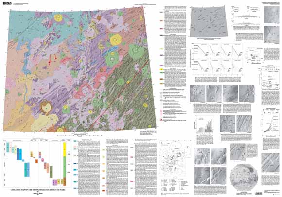
A principal motivation for mapping the Tempe-Mareotis region is to examine the low volcanic shields and lava plains that represent a style of volcanism unlike the styles of volcanism of the vast ridged plains and the large Tharsis Montes volcanoes. The goal is to place the volcanism in a spatial and temporal context with other volcanism on Mars, especially the volcanism that produced the Tharsis Montes volcanic chain (Arsia, Pavonis, and Ascraeus Montes). The Tempe-Mareotis region lies along a great circle that passes through the Tharsis shield volcanoes and Uranius Patera (fig. 1, see map sheet for all figures). Also of interest is the predominantly extensional tectonism that preceded, accompanied, and followed the volcanism. The geologic record of the region is complicated by the interplay of volcanic, tectonic, and fluvial processes.
The Tempe-Mareotis region has been the subject of volcanic (Plescia, 1980, 1981; Hodges, 1980) and tectonic (Scott and Dohm, 1990; Davis and others, 1995; Golombek and others, 1996) studies. The geology of this region has been mapped at 1:25,000,000 (Scott and Carr, 1978), 1:5,000,000 (Wise, 1979), and 1:15,000,000 (Scott and Tanaka, 1986) scales.
Six l:500,000-scale controlled photomosaics (U.S. Geological Survey, 1991a–f) were combined and then reduced to 1:1,000,000 scale to form the base for this map. The 1:500,000-scale photomosaics and Viking Orbiter images were used extensively to prepare this map. Image quality varies because of resolution and, perhaps, atmospheric conditions (in parts of the northwest corner of the region). Two sets of images (448B and 299A) that are not included in the photomosaic have resolutions of 8-12 m/pixel. The 448B images provide useful, but limited, coverage from about lat 34.5° N., long 82.2° W. to about lat 36.9° N., long 81.8° W., but the 299A images are not useful because of hazy atmosphere. Problems with the photomosaic base that do not seriously affect the results of this study include: (1) mismatches of images from different orbits, which result in offsets or even missing topographic features, and (2) adjoining images with differing illumination directions.
Last modified March 21, 2012
First posted January 8, 2004
For additional information:
Contact Astrogeology Research Program staff
Astrogeology Science Center
U.S. Geological Survey
2255 N. Gemini Dr.
Flagstaff, AZ 86001
http://astrogeology.usgs.gov/
This report is presented in Portable Document Format (PDF); the latest version of Adobe Reader or similar software is required to view it. Download the latest version of Adobe Reader, free of charge.
Moore, H.J., 2001, Geologic map of the Tempe-Mareotis region of Mars: U.S. Geological Survey Geologic Investigations Series I–2727, available at https://pubs.usgs.gov/imap/i2727/.

![]() U.S. Department of the Interior |
U.S. Geological Survey
U.S. Department of the Interior |
U.S. Geological Survey
URL: http://pubsdata.usgs.gov/pubs/imap/i2727/index.html
Page Contact Information: GS Pubs Web Contact
Page Last Modified: Wednesday, 30-Nov-2016 17:36:19 EST
