U.S. Geological Survey Geologic Investigations Series I–2730
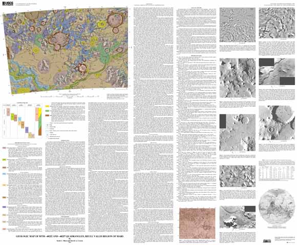
Mars Transverse Mercator (MTM) quadrangles –40252 and –40257 cover a portion of the highlands of Promethei Terra northeast of the Hellas basin. The map area consists of heavily cratered ancient highland materials of moderate to high relief, isolated knobs and massifs of rugged mountainous materials, extensive tracts of smooth and channeled plains, and other surficial deposits. Reull Vallis, an approximately 1,500 km-long outflow channel system, cuts through the southeast corner of the map area. Regional slopes are to the southwest, toward the Hellas basin, as indicated by Martian topographic maps and the orientations of channels along the northeast rim of the Hellas basin. The Martian highlands cover more than 60 percent of the planet‘s surface and are primarily in the southern hemisphere. Most of the highlands consist of rugged, densely cratered terrains believed to represent the final phase of heavy bombardment in the inner solar system about 4.0 billion years ago. Parts of the Martian highlands show evidence of extensive degradation and modification. The map area shows landforms created by numerous geologic processes, including tectonism, fluvial activity, and mass wasting. The occurrence of fluvial features, such as outflow channels and valley networks, has significant implications for past Martian conditions. Determining the geology of the highlands northeast of the Hellas basin provides a better understanding of the role and timing of volatile-driven activity in the evolution of the highlands. Photogeologic mapping at 1:500,000 scale from analysis of Viking Orbiter images complements geomorphic studies of Reull Vallis and other highland outflow systems, of drainage networks, and of highland debris aprons and regional geologic mapping studies of the highlands at the 1:2,000,000 scale and 1:1,000,000 scale. Crater size-frequency distributions have been compiled to constrain the relative ages of geologic units and determine the timing and extents of the observed geologic processes.
Last modified March 21, 2012
First posted May 2, 2003
For additional information:
Contact Astrogeology Research Program staff
Astrogeology Science Center
U.S. Geological Survey
2255 N. Gemini Dr.
Flagstaff, AZ 86001
http://astrogeology.usgs.gov/
This report is presented in Portable Document Format (PDF); the latest version of Adobe Reader or similar software is required to view it. Download the latest version of Adobe Reader, free of charge.
Mest S.C., and Crown, D.A. 2002, Geologic map of MTM–40252 and –40257 quadrangles, Reull Vallis Region, Mars: U.S. Geological Survey Geologic Investigations Series I–2730, available at https://pubs.usgs.gov/imap/i2730/.

![]() U.S. Department of the Interior |
U.S. Geological Survey
U.S. Department of the Interior |
U.S. Geological Survey
URL: http://pubsdata.usgs.gov/pubs/imap/i2730/index.html
Page Contact Information: GS Pubs Web Contact
Page Last Modified: Wednesday, 30-Nov-2016 17:39:24 EST
