
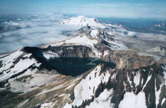
Aerial view along the main volcanic chain from the caldera lake of Mount Katmai across the craggy peaks of Trident Volcano to snow-clad Mount Mageik, a distance of about 20 km. (Photograph by Wes Hildreth and Judy Fierstein)
The Katmai volcanic cluster on the Alaska Peninsula was first brought to national and international attention by the great eruption of June 1912. Although many wilderness travellers and one geological party had previously crossed remote Katmai Pass on foot, the National Geographic Society expeditions of 1915-19 first mapped and reconnoitered the volcanic terrain surrounding the pass in the course of investigating the effects of the 1912 eruption. The explosive ejection of rhyolitic, dacitic, and andesitic magma at Novarupta over an interval of about 60 hr on June 6-8, 1912, was the world's most voluminous 20th century eruption. At least 17 km3 of fall deposits and 11±3 km3 of ash-flow tuff (ignimbrite) were produced, representing a magma volume of about 13 km3. This volume is larger than that erupted by Krakatau (Indonesia) in 1883 and is known to have been exceeded by only four eruptions in the last 1,000 years. Syneruptive caldera collapse at Mount Katmai, 10 km east of the eruption site, and displacements elsewhere in the magmatic plumbing system generated 14 earthquakes in the magnitude range Ms 6 to 7 (extraordinarily energetic for volcanic seismicity) and as many as 100 greater than Ms 5. Within 15 km of the 1912 vent at Novarupta, five andesite-dacite stratovolcanoes have erupted during the Holocene and remain fumarolically active today: Mount Katmai, Trident Volcano, Mount Mageik, Mount Martin, and Mount Griggs. The first four are virtually contiguous along a N.65°E. trend that defines the Quaternary volcanic front, whereas rear-arc Mount Griggs is centered 12 km behind the front. The frontal trend additionally includes Snowy Mountain, likewise active in the Holocene, which consists of a pair of andesite-dacite cones 10-15 km northeast of Mount Katmai; and the extinct Alagogshak Volcano, an andesite-dacite Pleistocene edifice centered 3 km southwest of Mount Martin. We have recently mapped and studied all of the volcanoes named, some of which are compound multi-vent edifices, as portrayed on the geologic map. |
| File
Name |
File
Type and Description |
File
Size |
| | ||
| FILES for VIEWING and PLOTTING (Both tagged and untagged versions follow.) |
||
| PDF file of the 45-page descriptive geologic pamphlet that accompanies the map | 2.8 MB |
|
| for accessibility using assistive technology such as screen readers | 3 MB |
|
| PDF file of 62" x 43" map sheet that can be used for viewing map in a browser, as well as for plotting (geologic map, description of map units, correlation of map units, and photographs) | 25.1
MB |
|
| README |
||
| Text-only readme file that explains the contents of the two data files | 4 KB |
|
| DATA |
||
| Metadata | 328 KB |
|
| Zipped file that contains database for geologic map in ArcInfo-coverage format | 15-MB file that opens into a 41-MB folder |
|
| Zipped file that contains digital photographs of the Katmai Cluster volcanoes | 2.8-MB file that opens into a 3.9-MB folder |
|
For questions about the content of this report, contact Wes Hildreth
Download a current version of Acrobat Reader for free
| Help
| PDF help
| Western reports main page |
| Western Geologic and Miscellaneous Investigation Series Maps |
| Privacy
Statement | Disclaimer
| Accessibility |
| Geologic
Division | Volcano Hazards Program
|
This report is also available from:
USGS Information Services, Box 25286,
Federal Center, Denver, CO 80225
telephone: 303-202-4210; e-mail: infoservices@usgs.gov