
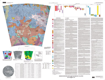
| INTRODUCTION The Aino Planitia quadrangle (V-46) extends from 25º-50º S. latitude, 60º-90º E. longitude. The quadrangle was mapped at 1:5,000,000 scale as part of the NASA Planetary Geologic Mapping Program. Aino Planitia is a lowland region in the southern hemisphere of Venus and is southwest of Thetis Regio in western Aphrodite Terra. It is dominated by low-lying plains units that are characterized by northeast-trending wrinkle ridges and numerous small volcanic edifices, including shields, domes, and cones. The quadrangle contains a major volcano, Kunapipi Mons, and portions of Juno Chasma. A northern extension of the Lada Terra highland is in the southwestern portion of the map. Eight coronae are mapped in the quadrangle, the largest of which is the 500-km-diameter Copia Corona. The region is dominated by plains that are interpreted to be of volcanic origin. Most of the plains units are composites of flow units of differing ages. The overall topography of V-46 consists of low-lying plains slightly below Mean Planetary Radius (MPR, 6051.84 km). The summit of Kunapipi Mons is the highest point in the quadrangle, at about 2.2 km above MPR; the lowest points in rifts and troughs are at about 1.7 km below MPR. The regions that are the roughest at Magellan radar wavelengths in the quadrangle occur along the rim of Copia Corona, with most regions being relatively smooth (roughness comparable to the average Venus surface. Emissivity values in the quadrangle vary from 0.82-0.90. |
Download this map as a PDF document (52 x 40 inches; 13.6 MB)
Download a current version of Acrobat Reader for free
| Help | PDF help | Geopubs main page | Other Planetary Maps |
| Privacy Statement | Disclaimer | Accessibility |
| Geologic Division | Astrogeology Research Program |
This map is also available from:
USGS Information Services, Box 25286,
Federal Center, Denver, CO 80225
telephone: 303-202-4210; e-mail: infoservices@usgs.gov