Geologic Investigations Series I-2781
|
|
|
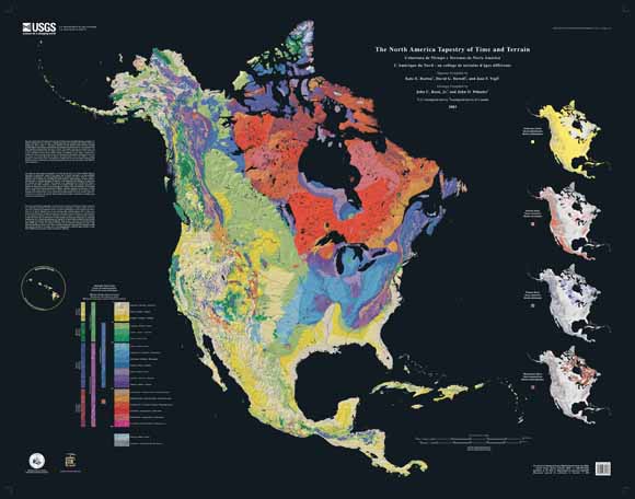
ABSTRACT The North
America Tapestry of Time and Terrain (1:8,000,000 scale) is a product
of the US Geological Survey in the I-map series (I-2781). This map was prepared
in collaboration with the Geological Survey of Canada and the Mexican
Consejo Recursos de Minerales. This cartographic
Tapestry is woven from a geologic map and a shaded relief image. This
digital combination reveals the geologic history of North America through
the interrelation of rock type, topography and time. Regional surface
processes as well as continent-scale tectonic events are exposed in the
three dimensions of space and the fourth dimension, geologic time. The
large map shows the varying age of bedrock underlying North America, while
four smaller maps show the distribution of four principal types of rock:
sedimentary, volcanic, plutonic and metamorphic. This map expands the original concept of the 2000 Tapestry of Time and Terrain, by José F. Vigil, Richard J. Pike and David G. Howell, which covered the conterminous United States. The U.S. Tapestry poster and website have been popular in classrooms, homes, and even the Google office building, and we anticipate the North America Tapestry will have a similarly wide appeal, and to a larger audience. |
These files work best when you download them to your computer's hard disk and viewing them with the regular stand-alone version of Acrobat. To get your computer to download, right-click (PC) or Control click (Mac) on the links below.
Geologic data were compiled by John C. Reed, Jr. (USGS) and John O. Wheeler (Geological Survey of Canada), for the Decade of North American Geology Geologic Map of North America, sponsored by the Geological Society of America. These geologic data were simplified and generalized by David G. Howell (USGS). The shaded relief map was created from 1-km resolution digital elevation data.
For additional information, contact:
Geology, Minerals, Energy, and Geophysics Science Center
Building 19, 350 N. Akron Rd.
P.O. Box 158
Moffett Field, CA 94035
Download a current version of Adobe Acrobat Reader for free
This map is also available from:
USGS Information
Services, Box 25286,
Federal Center, Denver, CO 80225
Telephone: 303-202-4210; e-mail: infoservices@usgs.gov

![]() U.S. Department of the Interior |
U.S. Geological Survey
U.S. Department of the Interior |
U.S. Geological Survey
URL: http://pubsdata.usgs.gov/pubs/imap/i2781/index.html
Page Contact Information: GS Pubs Web Contact
Page Last Modified: Tuesday, 09-Jan-2024 12:31:03 EST