
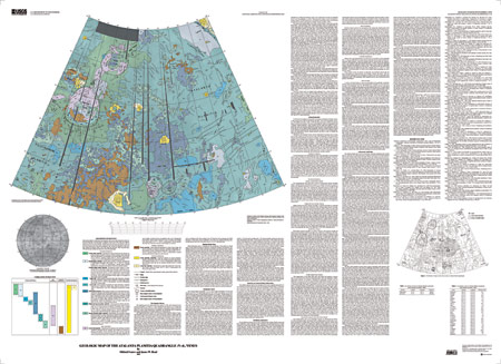
| INTRODUCTION The Atalanta Planitia quadrangle (V-4) is in the northern hemisphere of Venus and extends from 50º to 75º north latitude and from 120º to 180º east longitude. It covers the central and western part of Atalanta Planitia and parts of its margins. Atalanta Planitia consists of a centralized deformed lowland flooded by volcanic deposits and surrounded by Nightingale and Earhart Coronae in Tethus Regio to the wes, Ananke Tessera and Vellamo Planitia to the southwest, an extensive zone of ridge belt to the east , Vellamo and Ganiki Planitiae to the south, Louhi Planitia to the northwest, and Lukelong Dorsa to the northeast. In contrast to more elongate lowland areas on Venus, the Atalanta Planitia area is one of several large, somewhat equidimensional lowlands (basins) and as such is an important region for the analysis of processes of basin formation and volcanic flooding. Before the Magellan mission, Atalanta Planitia was known on the basis of Pioneer Venus altimetry to be a lowland area; Venera 15 and 16 radar images showed that it was surrounded by several coronae and coronalike features from the west and by numerous ridge belts parallel to the basin margin to the east. Venera 15 and 16 data also revealed that the interior was populated with complex patterns of deformational features in the form of belts of ridges and volcanic plains, and several regions along the margins were seen to be the sources of large radar-bright areas, interpreted to be lava flows. Early Magellan results showed that the ridge belts are composed of complex deformational structures interpreted as predominantly of contractional origin and that the complex lava flows along the margins emanated from coronae at western and southwestern edges of Atalanta Planitia. In addition, global analysis of the distribution of volcanic features revealed that the interior of Atalanta Planitia is somewhat deficient in distinctive volcanic sources and coronalike features. Atalanta Planitia gravity and geoid data show that the lowland is characterized by a -35 mGal gravity anomaly and a -55 m geoid anomaly, centered on eastern Atalanta. Indeed, the characteristics and configuration of Atalanta Planitia have been cited as evidence for the region being the site of large-scale mantle downwelling. Thus, this region is a laboratory for the study of the formation of lowlands, the emplacement of volcanic plains, the formation of associated tectonic features, and their relation to mantle processes. These questions and issues are the basis for our geologic mapping analysis. In our analysis we have focused on the geologic mapping of the Atalanta Planitia quadrangle using traditional methods of geologic unit definition and characterization for Earth and planets appropriately modified for radar data (Tanaka, 1994). We defined units and mapped key relations using the full-resolution Magellan synthetic aperture radar (SAR) data (mosaicked full-resolution basic image data records, C1- MIDR's, F-MIDR's, and FMAP's) and transferred these results to the base map compiled at a scale of 1:5 million. In addition to the SAR image data, we incorporated into our analyses digital versions of Magellan altimetry, emissivity, Fresnel reflectivity, and roughness data (root mean square, rms, slope) to characterize the surface properties of the units mapped. |
Download this map as a PDF document (54 x 40 inches; 28.9 MB)
Download a current version of Acrobat Reader for free
| Help | PDF help | Geopubs main page | Other Planetary Maps |
| Privacy Statement | Disclaimer | Accessibility |
| Geologic Division | Astrogeology Research Program |
This map is also available from:
USGS Information Services, Box 25286,
Federal Center, Denver, CO 80225
telephone: 303-202-4210; e-mail: infoservices@usgs.gov