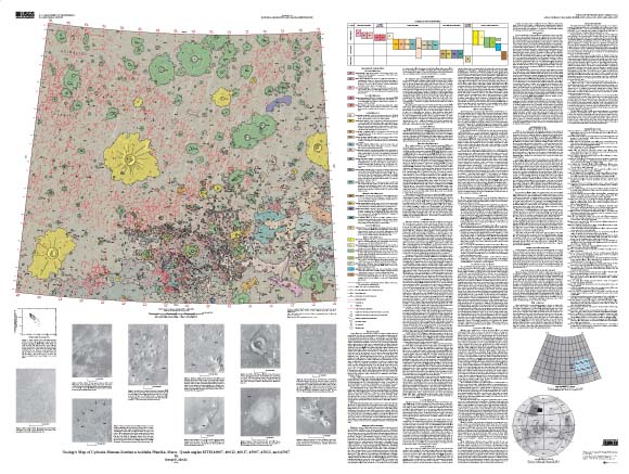
| INTRODUCTION Cydonia Mensae lie adjacent to the boundary separating the highland terrain of western Arabia Terra from the northern lowlands (the dichotomy boundary), where this boundary is gradational rather than abrupt, as is generally the case. Cydonia Mensae are characterized by abundant knobs and mesas, most of which occur in well defined clusters that commonly are long and narrow. The adjacent lowland of Acidalia Planitia contains abundant troughs that define a crude, very large scale polygonal pattern. This pattern, and the troughs, are similar in size and spacing to those in Utopia Planitia (for example, McGill and Hills, 1992; Hiesinger and Head, 2000). The six 1:500,000-scale quadrangles mapped are MTM 40007, 40012, 40017, 45007, 45012, and 45017, which include northern Cydonia Mensae, part of southern Acidalia Planitia, and a small area of Arabia Terra highlands. These six quadrangles are combined into a single map at 1:1,000,000 scale for this publication. Issues of interest addressed by this mapping include the crustal history implied by the knobs and mesas of Cydonia Mensae, the implications of the gradational dichotomy boundary, the age of the Acidalia plains materials, the origin and age of the giant polygons, the validity of putative shorelines inferred to be present in this area, and the origin of the very abundant small cones and domes, specifically if these imply the past presence of water or ice within the plains materials. Earlier maps (Witbeck and Underwood, 1984; Scott and Tanaka, 1986; Tanaka and others, 2003) that included the area mapped for this study addressed some or all of these issues, but these maps were more regional in coverage and were at smaller scales. In addition, new orbital data from Mars Global Surveyor and Mars Odyssey missions were available only to Tanaka and others (2003). The intent of this present study is to address the issues listed by mapping at a scale large enough to permit greater map detail and to better understand the areal distribution of the materials and features of interest. |
Download this map as a PDF document (~55 x 42 inches; 24.6 MB)
For questions about the content of this report, contact Ken Tanaka
Download a current version of Acrobat Reader for free
| Help
| PDF help
| Geopubs main page | Other
Planetary Maps |
| Privacy
Statement | Disclaimer
| Accessibility |
| Geologic Division |
Astrogeology Research Program |
This map is also available from:
USGS Information Services, Box 25286,
Federal Center, Denver, CO 80225
telephone: 303-202-4210; e-mail: infoservices@usgs.gov