
The panels' major recommendations, however, were to develop two new tools as a first priority -- empirical rate-of-occurrence models for important mineral-deposit types (which aid in the subjective assessment of the number of undiscovered deposits in a given area) and economic cost filters.
New Tools and MethodsThe principal elements in a mineral-resource assessment are shown in figure 1. On the left are earth science data on which a mineral-resource assessment is based -- a map of land tracts that may contain particular types of mineral deposits (that is, delineated tracts permissive for a particular mineral), estimates of undiscovered deposits by type, and grade-tonnage models. Resource, economic, and policy analysis tools are shown in the center of the figure, and various assessment results are portrayed on the right. Maps of delineated tracts have traditionally been made by integrating various kinds of geoscience data using descriptive mineral-deposit models. Current research is directed to developing neural network (an empirical data-driven procedure) representations of mineral-deposit models from which maps of delineated tracts can be generated. Figure 2 depicts the basic elements of the neural network representation process. The input (on the left of the figure) includes deposit and occurrence data; geochemical, geophysical, and geologic data; and historical data. These data are integrated empirically (in the center of the figure), and the output (on the right of the figure) is a map of delineated mineral-resource tracts. Figure 3 is a map of delineated tracts permissive for the occurrence of pluton-related deposits. The map was drawn by using neural network representations of mineral-deposit models. The red dots represent deposits classified by the neural model as being pluton related. By placing a 5-kilometer buffer around these deposits, a new map of tracts can be generated automatically. |
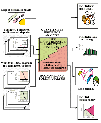
Figure 1. Elements of a mineral-resource assessment. |

Figure 2. Neural network integration of various kinds of earth science data used to delineate mineral-resource tracts. |

Figure 3. Tracts permissive for pluton-related deposits in Nevada. This map was created by using a neural network representation of a mineral-deposit model. |

Figure 4. Example of a target-recognition map. The map shows areas with enhanced probability for occurrence within a larger permissive area created by a strike-slip fault system associated with a collisional orogen. |
Using Economic Cost FiltersThe second recommendation by the review panels was to develop economic cost filters to facilitate the translation of physical resources into societally meaningful measures of those resources. Economic filters define the boundary in grade-tonnage space between deposits that are estimated to be economically producible at a stated rate of return and those that are not. These filters are based on the application of simplified models of mining and milling to deposits used to construct grade-tonnage models. Economic filters are used to estimate the part of the undiscovered mineral resources that may be of interest at stated conditions of price, rate of return, and location. Figure 5 shows the application of an economic cost filter to grade-tonnage data from a collection of porphyry copper deposits. Deposits shown as "Eľ" in this figure are estimated to be economic at a 10-percent internal rate of return (a 10-percent economic cost filter). |

Figure 5. Application of an economic cost filter for porphyry copper deposits in Alaska and in British Columbia and the Yukon Territory, Canada. Deposits shown as "E" are estimated to be economic at a 10-percent internal rate of return; that is, a 10-percent economic cost filter. |
|
For more information, please contact:
Lawrence J. Drew U.S. Geological Survey 954 National Center Reston, VA 20192 |
|
|
E-mail: ldrew@usgs.gov |
|
U.S. Department of the Interior U.S. Geological Survey |
USGS Information Handout July 1998 |