 Summary Summary
Volcanic eruptions and related phenomena can be
expected to occur in the Western United States, and
in some places are potentially hazardous enough to be
considered in longe-range land-use planning. But the
immediate risk from volcanic hazards is low because
eruptions are so infrequent in the conterminous United
States that few, if any, occur during any one person's
lifetime. Furthermore, severely destructive effects
of eruptions, other than extremely rare ones of catastrophic
scale, probably would be limited to areas
within a few tens of kilometers downvalley or downwind
from a volcano. Thus, the area seriously endangered
by any one eruption would be only a very small part of
the Western United States.
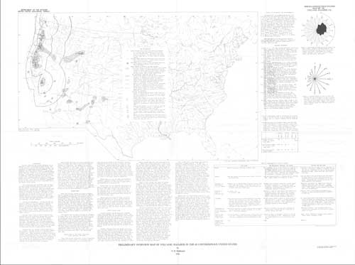
The accompanying map identifies areas in which
volcanic hazards pose some degree of risk, and shows
that the problem is virtually limited to the far western
States. The map also shows the possible areal
distribution of several kinds of dangerous eruptive
events and indicates the relative likelihood of their
occurrence at various volcanoes. The kinds of events
described here as hazards are those that can occur
suddenly and with little or no warning; they do not
include long-term geologic processes. Table 1 summarizes
the origin and some characteristics of potentially
hazardous volcanic phenomena.
The map is diagrammatic. It does not show the
specific location of the next expected eruption , because
such an event cannot be reliably predicted .
Instead, the map shows general areas or zones that,
over a long period of time, are relatively likely to
be affected in one or more places by various kinds
of hazardous volcanic events. However, only a small
part of one of these areas would be affected by any
single eruption.
|
First posted June 20, 2014
- This map is available only on the Web
Part or all of this report is presented in Portable Document Format (PDF). For best results viewing and printing PDF documents, it is recommended that you download the documents to your computer and open them with Adobe Reader. PDF documents opened from your browser may not display or print as intended. Download the latest version of Adobe Reader, free of charge.
|

