Miscellaneous Field Studies Map MF-1186
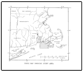
IntroductionThis report presents results of marine studies conducted by the U.S. Geological Survey (USGS) during the summers of 1975 and 1976 in eastern Rhode Island Sound and Vineyard Sound (fig. 1) located off the southeastern coast of Massachusetts. The study was made in cooperation with the Massachusetts Department of Public Works and the New England Division of the U.S. Army Corps of Engineers. It covered an area of the Atlantic Inner Continental Shelf between latitude 41° 12' and 41° 33'N, and between longitude 70° 37' and 71° 15'W (see index map). Major objectives included assessment of sand and gravel resources, environmental impact evaluation both of offshore mining of these resources and of offshore disposal of solid waste and dredge spoil material, identification and mapping of the offshore geology, and determination of the geologic history of this part of the Inner Shelf. A total of 670 kilometers (km) of closely spaced high-resolution seismic-reflection profiles, 224 km of side-scan sonar data, and 16 cores totaling 90 meters (m) of recovered sediment, were collected during the investigation. This report is companion to geologic maps published for Cape Cod Bay (Oldale and O'Hara, 1975) and Buzzards Bay, Mass. (Robb and Oldale, 1977). |
Part or all of this report is presented in Portable Document Format (PDF); the latest version of Adobe Reader or similar software is required to view it. Download the latest version of Adobe Reader, free of charge. |
O'Hara, C.J., and Oldale, R.N., 1980, Maps showing geology and shallow structure of eastern Rhode Island Sound and Vineyard Sound, Massachusetts: U.S. Geological Survey Miscellaneous Field Studies Map MF-1186, 41 p.

![]() U.S. Department of the Interior |
U.S. Geological Survey
U.S. Department of the Interior |
U.S. Geological Survey
[an error occurred while processing this directive]
URL: https://pubsdata.usgs.gov
Page Contact Information: Contact USGS
Page Last Modified: Thursday, 01-Dec-2016 12:10:28 EST
