Miscellaneous Field Studies Map MF-1537
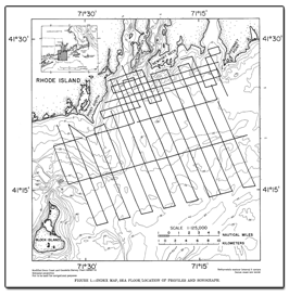
IntroductionThis report presents the results of a high-resolution, seismic-reflection, and sidescan-sonar survey conducted in western Rhode Island Sound south of Narragansett Bay (fig. 1 inset) by the U.S. Geological Survey in 1980. The study defines the geologic framework of the Atlantic Inner Continental Shelf between lat. 41°09' and 41°32'N and long. 71°07' and 71°37'W. A total of 580 kilometers (km) of seismic-reflection profiles and 580 km of sidescan sonographs was collected aboard the RV Neecho. Trackline spacing was 1 to 2 km at the mouth of Narragansett Bay, and dip lines were 2 km apart with widely spaced strike lines in Rhode Island Sound (fig. 1). The maps in this report adjoin those for eastern Rhode Island Sound and Vineyard Sound, Massachusetts, of O'Hara and Oldale (1980). |
Part or all of this report is presented in Portable Document Format (PDF); the latest version of Adobe Reader or similar software is required to view it. Download the latest version of Adobe Reader, free of charge. |
Needell, S.W., O'Hara, C.J., and Knebel, H.J., 1983, Maps showing geology and shallow structure of western Rhode Island Sound, Rhode Island: U.S. Geological Survey Miscellaneous Field Studies Map MF-1537, 34 p.

![]() U.S. Department of the Interior |
U.S. Geological Survey
U.S. Department of the Interior |
U.S. Geological Survey
[an error occurred while processing this directive]
URL: https://pubsdata.usgs.gov
Page Contact Information: Contact USGS
Page Last Modified: Thursday, 01-Dec-2016 12:10:33 EST
