marshallsc - 200-m contours extracted from gridded bathymetric data for the Republic of the Marshall Islands

Metadata also available as - [Outline] - [Parseable text]

Frequently-anticipated questions:


What does this data set describe?

Title:
marshallsc - 200-m contours extracted from gridded bathymetric data for the Republic of the Marshall Islands
Abstract:
200-m contours extracted from gridded bathymetric data for the Republic of the Marshall Islands
  1. How should this data set be cited?

    Wong, Florence L. , 2007, marshallsc - 200-m contours extracted from gridded bathymetric data for the Republic of the Marshall Islands: USGS Miscellaneous Field Studies Map MF 2324.

    Online Links:

  2. What geographic area does the data set cover?

    West_Bounding_Coordinate: 153.000003
    East_Bounding_Coordinate: 174.999401
    North_Bounding_Coordinate: 17.002898
    South_Bounding_Coordinate: 2.999995

  3. What does it look like?

    <https://pubs.usgs.gov/mf/1999/2324/images/marshzoom.jpg> (JPEG)
    preview image of report

  4. Does the data set describe conditions during a particular time period?

    Calendar_Date: 1998
    Currentness_Reference: ground condition

  5. What is the general form of this data set?

    Geospatial_Data_Presentation_Form: vector digital data

  6. How does the data set represent geographic features?

    1. How are geographic features stored in the data set?

      This is a Vector data set. It contains the following vector data types (SDTS terminology):

      • String (6976)

    2. What coordinate system is used to represent geographic features?

      Horizontal positions are specified in geographic coordinates, that is, latitude and longitude. Latitudes are given to the nearest 0.001. Longitudes are given to the nearest 0.001. Latitude and longitude values are specified in Decimal degrees.

      The horizontal datum used is D_WGS_1984.
      The ellipsoid used is WGS_1984.
      The semi-major axis of the ellipsoid used is 6378137.000000.
      The flattening of the ellipsoid used is 1/298.257224.

  7. How does the data set describe geographic features?

    Entity_and_Attribute_Overview:
     CONTOUR integer, water depth
     HATCH   flag for type of contours:
            0 unflagged
            1 contours around depressions
            2 contours around local maximum
            3 unknown, identifies long regional contours
            4 unknown, flags long contour in northwest
    
    Entity_and_Attribute_Detail_Citation: none


Who produced the data set?

  1. Who are the originators of the data set? (may include formal authors, digital compilers, and editors)

  2. Who also contributed to the data set?

  3. To whom should users address questions about the data?

    Florence L. Wong
    U.S. Geological Survey (USGS) Coastal and Marine Geology (CMG)
    Geologist
    345 Middlefield Road, MS 999
    Menlo Park, California 94025-3561
    USA

    650-329-5327 (voice)
    650-329-5190 (FAX)
    fwong@usgs.gov


Why was the data set created?

These data are intended for science researchers, students, policy makers, and the general public. The data can be used with geographic information systems (GIS) software to display geologic and oceanographic information.


How was the data set created?

  1. From what previous works were the data drawn?

  2. How were the data generated, processed, and modified?

    Date: 26-Apr-2007 (process 1 of 2)
    Extracted shapefiles for 200-m contours extracted from Marshall Islands grid.

    Removed depression contours from southern Kwajalien per inspection of latest version of ETOPO2 data <http://www.ngdc.noaa.gov/mgg/fliers/06mgg01.html>. Parent grid unchanged.

    Date: 27-Apr-2007 (process 2 of 2)
    Metadata imported.

  3. What similar or related data should the user be aware of?


How reliable are the data; what problems remain in the data set?

  1. How well have the observations been checked?

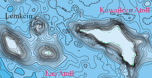
    The bathymetry and coastline data and other line data were merged and edited in ARC/INFO, which caused some edge-matching problems among the data sets. The new USGS-KORDI survey bathymetry data were desampled to a 250-m spacing. A buffer zone 4500 m to either side of the new data was used to mask out the underlying two-minute data. The resulting data sets were combined to construct a surface according to the triangular irregular network (TIN) model supported by ARC/INFO. The data were gridded on 1000-m grid cells with a smoothing (quintic) option. Contours were extracted at 200-m intervals. Final map was compiled and edited in Adobe Illustrator, v. 8.0.1.

  2. How accurate are the geographic locations?

  3. How accurate are the heights or depths?

  4. Where are the gaps in the data? What is missing?

    Complete

  5. How consistent are the relationships among the observations, including topology?

    Chain-node topology present.


How can someone get a copy of the data set?

Are there legal restrictions on access or use of the data?

Access_Constraints: None.
Use_Constraints:
These data are not to be used at scales greater than 1:1,000,000. Not intended for navigation use.

  1. Who distributes the data set? (Distributor 1 of 1)

    U.S. Geological Survey (USGS) and Coastal and Marine Geology (CMG)
    c/o Florence L. Wong
    Geologist
    345 Middlefield Road, MS 999
    Menlo Park, California 94025-3561
    USA

    650-329-5327 (voice)
    650-329-5190 (FAX)
    fwong@usgs.gov

  2. What's the catalog number I need to order this data set?

    Downloadable Data

  3. What legal disclaimers am I supposed to read?

    Please recognize the U.S. Geological Survey (USGS) as the source of this information.

    Although these data have been used by the U.S. Geological Survey, U.S. Department of the Interior, no warranty expressed or implied is made by the U.S. Geological Survey as to the accuracy of the data.

    The act of distribution shall not constitute any such warranty, and no responsibility is assumed by the U.S. Geological Survey in the use of this data, software, or related materials.

  4. How can I download or order the data?


Who wrote the metadata?

Dates:
Last modified: 27-Apr-2007
Metadata author:
United States Geological Survey (USGS)
c/o Florence L. Wong
Geologist, GIS Coordinator
USGS, MailStop 999, 345 Middlefield Road
Menlo Park, CA 94025-3561
USA

(650) 329-5327 (voice)
(650) 329-5190 (FAX)
fwong@usgs.gov

Metadata standard:
FGDC Content Standards for Digital Geospatial Metadata (FGDC-STD-001-1998)
Metadata extensions used:


Generated by mp version 2.8.11 on Fri Apr 27 14:27:50 2007