This bathymetric map of the Republic of the Marshall Islands was constructed from (1) unpublished data collected during recent surveys conducted by the USGS and KORDI (J.W. Moon and K.Y. Lee; Hein and others, in press), (2) the two-minute gridded satellite altimetry data from Smith and Sandwell (1997), and (3) coastline data from the Generic Mapping Tools (GMT) software (Wessel and Smith, 1995) and Chase and others (1984).
The spellings of island, atoll, and seamount names follow the recommendation of the Republic of the Marshall Islands government and are consistent with those in the Marshallese-English dictionary, including the diacritical marks (Abo and others, 1976). We were provided a list of names for the seamounts by Alfred Capelle (Alele Museum and National Archives, now located at the College of the Marshall Islands), who solicited those traditional names from village leaders from the various islands. We applied the appropriate names to seamounts located within specifically defined sectors adjacent to the various atolls and islands. The names are primarily from Marshallese legends and the meaning of each is provided by Hein and others (1990).
Files provided in zipped file-
marsh200c.shp marshalls.txt marshalls.xyz marshallsg.asc marshallsg.prj
Additional information about the field activities from which this data set was derived are available online at <URL:http://walrus.wr.usgs.gov/infobank/f/f1089cp/html/f-10-89-cp.meta.html> <URL:http://walrus.wr.usgs.gov/infobank/f/f1190cp/html/f-11-90-cp.meta.html> <URL:http://walrus.wr.usgs.gov/infobank/o/o198wp/html/o-1-98-wp.meta.html>
Any use of trade, product, or firm names is for descriptive purposes only and does not imply endorsement by the U.S. Government.
Although this Federal Geographic Data Committee-compliant metadata file is intended to document the data set in nonproprietary form, as well as in ArcInfo format, this metadata file may include some ArcInfo-specific terminology.
Wong, Florence L. , Hein, James R. , and Mosier, Dan L. , 1999, Gridded bathymetric data for the Republic of the Marshall Islands: USGS Miscellaneous Field Studies Map MF 2324, U.S. Geological Survey, Menlo Park, CA.Online Links:
This is a Raster data set. It contains the following raster data types:
Horizontal positions are specified in geographic coordinates, that is, latitude and longitude. Latitudes are given to the nearest 0.01. Longitudes are given to the nearest 0.01. Latitude and longitude values are specified in Decimal Degrees.
The horizontal datum used is WGS84.
The ellipsoid used is WGS84.
The semi-major axis of the ellipsoid used is 6378206.4.
The flattening of the ellipsoid used is 1/294.98.
MARSHALLSG.STA:  elevation statistics (meters)

           MIN             MAX            MEAN            STDV
      -6617.944           0.000       -4693.243        1049.956
(650) 329-5327 (voice)
(650) 329-5190 (FAX)
fwong@usgs.gov
These data are intended for science researchers, students, policy makers, and the general public. The data can be used with geographic information systems (GIS) software to display geologic and oceanographic information.
Abo, Takaji, Bender, Byron W., Capelle, Alfred, and Debrum, Tony, 1976, Marshallese-English Dictionary: Honolulu University of Hawaii Press.
Chase, T.E., Seekins, B.A., and Lund, K.E., 1984, Marine physiography of the Marshall Islands: unpublished map.
Hein, J.R., Kang, Jung-Keuk, Schulz, M.S., and Park, Byong-Kwon; Kirschenbaum, Herbert; Yoon, Su, 1990, Geological, geochemical, geophysical, and oceanographic data and interpretations of seamounts and co-rich ferromanganese crusts from the Marshall Islands, KORDI-USGS R.V. Farnella Cruise F10-89-CP: U.S. Geological Survey Open-File Report 90-407.
Hein, J. R.; Moon, Jai-Woon; Lee, Kyeong, Dowling, J. S.; Kim, Ki-Hyune; Burrows, Mal, Park, S. H.; Choi, Youn-ji; Schuetze, A., Jung, H. S.; Kim, Hyun-Sub; Lee, G. C., and Park, Cheong-Kee; Son, S. K.; Park, Chan-Young, 1999, Co-rich Fe-Mn crusts from the Marshall Islands (Leg 1) and hydrothermal and hydrogenetic Fe-Mn deposits from Micronesia (Leg 2), KODOS 98-3 cruise, West Pacific: USGS Open-file Report 99-412, U.S. Geological Survey, Menlo Park, CA.
Smith, W.H.F., and Sandwell, D.T., 1997, Global seafloor topography from satellite altimetry and ship depth soundings: Science v. 277, no. 5334, p. 1956-1962..
Wessel, Paul, and Smith, W.H.F., 1995, The Generic Mapping Tools (GMT), version 3, technical reference and cookbook: Manoa, SOEST, University of Hawaii.
Person who carried out this activity:
(650) 329-5050 (voice)
(650) 329-5190 (FAX)
dmosier@usgs.gov
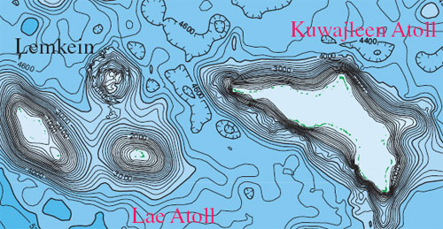
A 2006 version of the ETOPO2 data is currently available, but no update on the grid is planned at this time. Artifacts such as the "crater" in south Kwajalien remain in the grid.
The bathymetry and coastline data and other line data were merged and edited in ARC/INFO, which caused some edge-matching problems among the data sets. The new USGS-KORDI survey bathymetry data were desampled to a 250-m spacing. A buffer zone 4500 m to either side of the new data was used to mask out the underlying two-minute data. The resulting data sets were combined to construct a surface according to the triangular irregular network (TIN) model supported by ARC/INFO. The data were gridded on 1000-m grid cells with a smoothing (quintic) option. Contours were extracted at 200-m intervals. Final map was compiled and edited in Adobe Illustrator, v. 8.0.1.
Not available.
Bathymetry was compiled from unpublished data collected during recent surveys conducted by the USGS and the Korean Ocean Research Development Institute of Hein and others (in press) and published two-minute gridded satellite altimetry data of Smith and Sandwell (1997). Coastline data was compiled from the Generic Mapping Tools software of Wessel and Smith (1995) and Chase and others (1984). Marshallese place names follow the recommendation of the Republic of the Marshall Islands government and are consistent with those in the Marshallese-English dictionary of Abo and others (1976). Seamount names were provided by Alred Capelle of Alele Museum and National Archives, who solicited those traditional names from village leaders from the various islands.
Not applicable for raster data.
Are there legal restrictions on access or use of the data?
- Access_Constraints: None
- Use_Constraints:
- These data are not to be used at scales greater than 1:1,000,000.
(650) 329-5327 (voice)
(650) 329-5190 (FAX)
fwong@usgs.gov
U.S. Geological Survey Miscellaneous Field Studies Map MF 2324
Please recognize the U.S. Geological Survey (USGS) as the source of this information.Although these data have been used by the U.S. Geological Survey, U.S. Department of the Interior, no warranty expressed or implied is made by the U.S. Geological Survey as to the accuracy of the data.
The act of distribution shall not constitute any such warranty, and no responsibility is assumed by the U.S. Geological Survey in the use of this data, software, or related materials.
| Data format: | Compressed file including Arcinfo grid and metadata. (version 7.2) Arcinfo grid Size: 38 MB |
|---|---|
| Network links: |
<https://pubs.usgs.gov/mf/1999/2324/> |
(650) 329-5327 (voice)
(650) 329-5190 (FAX)
fwong@usgs.gov