U.S. Geological Survey Miscellaneous Field Studies MF–2342
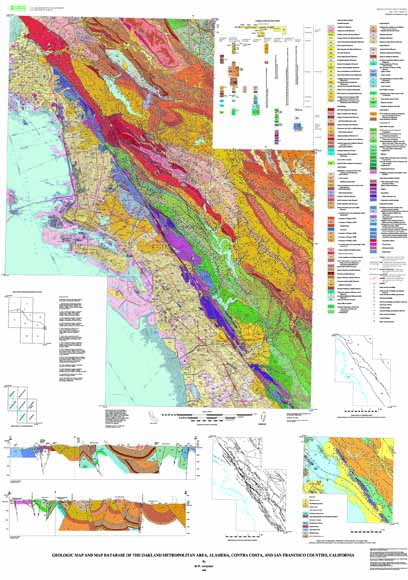
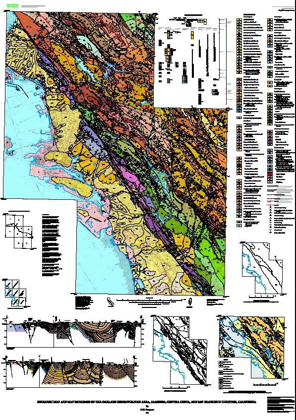
This report contains a new geologic map at 1:50,000 scale, derived from a set of geologic map databases containing information at a resolution associated with 1:24,000 scale, and a new description of geologic map units and structural relationships in the mapped area. The map database represents the integration of previously published reports and new geologic mapping and field checking by the author (see Sources of Data index map on the map sheet or the Arc-Info coverage pi-so and the textfile pi-so.txt). The descriptive text (below) contains new ideas about the Hayward fault and other faults in the East Bay fault system, as well as new ideas about the geologic units and their relations. These new data are released in digital form in conjunction with the Federal Emergency Management Agency Project Impact in Oakland.
The goal of Project Impact is to use geologic information in land-use and emergency services planning to reduce the losses occurring during earthquakes, landslides, and other hazardous geologic events. The USGS, California Division of Mines and Geology, FEMA, California Office of Emergency Services, and City of Oakland participated in the cooperative project. The geologic data in this report were provided in pre-release form to other Project Impact scientists, and served as one of the basic data layers for the analysis of hazard related to earthquake shaking, liquifaction, earthquake induced landsliding, and rainfall induced landsliding. The publication of these data provides an opportunity for regional planners, local, state, and federal agencies, teachers, consultants, and others outside Project Impact who are interested in geologic data to have the new data long before a traditional paper map could be published. Because the database contains information about both the bedrock and surficial deposits, it has practical applications in the study of groundwater and engineering of hillside materials, as well as the study of geologic hazards and the academic research on the geologic history and development of the region.
Files available for viewing
mf2342h.jpg Browse a jpeg graphic of the map (645 kb).
mf2342f.pdf PDF file of map sheet, screen optimized (4 MB).
mf2342g.pdf PDF file of map pamphlet, screen optimized (104 kb).
Files available for downloading as a package
mf2342a.tgz PostScript files of map sheet and pamphlet as a gzip compressed tar file (28 MB).
mf2342b.tgz PDF plotfiles of map and pamphlet as a gzip compressed tar file (16 MB)
Files available for downloading as individual files
mf2342i.pdf PDF file of map sheet, plotter optimized (15 MB).
mf2342j.pdf PDF file of pamphlet, plotter optimized (470 kb).
Database files available for downloading
mf2342e.met.txt ASCII text file, FGDC-compliant metadata (229 kb).
mf2342c.tgz Arc Info Export (.e00) and supporting files as a gzip compressed tar file (3 MB).
For additional information:
Contact Information, Western Region Geology and Geophysics Science Center—Menlo Park
U.S. Geological Survey
345 Middlefield Road, MS-973
Menlo Park, CA 94025-3591
http://geomaps.wr.usgs.gov/
R.W. Graymer, 2000, Geologic map and map database of the Oakland metropolitan area, Alameda, Contra Costa, and San Francisco Counties, California: U.S. Geological Survey Miscellaneous Field Studies MF–2342, scale 1:50,000. (Available at https://pubs.usgs.gov/mf/2000/2342/.)
Part of this report is presented in Portable Document Format (PDF); the latest version of Adobe Reader or similar software is required to view it. Download the latest version of Adobe Reader, free of charge.
Last modified June 27, 2012
First posted July 28, 2000

![]() U.S. Department of the Interior |
U.S. Geological Survey
U.S. Department of the Interior |
U.S. Geological Survey
URL: http://pubsdata.usgs.gov/pubs/mf/2000/2342/index.html
Page Contact Information: GS Pubs Web Contact
Page Last Modified: Thursday, 01-Dec-2016 12:07:25 EST
