
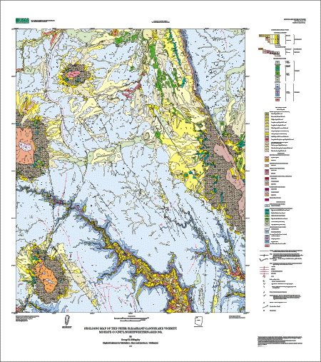
Geological map of the Upper Parashant Canyon area of Mojave county, Arizona.
The geologic map of the upper Parashant Canyon area covers part of the Colorado Plateau and several large tributary canyons that make up the western part of Arizona's Grand Canyon. The map is part of a cooperative U.S. Geological Survey and National Park Service project to provide geologic information for areas within the newly established Grand Canyon/Parashant Canyon National Monument. Most of the Grand Canyon and parts of the adjacent plateaus have been geologically mapped; this map fills in one of the remaining areas where uniform quality geologic mapping was needed. The geologic information presented may be useful in future related studies as to land use management, range management, and flood control programs for federal and state agencies, and private concerns.
The map area is in a remote region of the Arizona Strip, northwestern Arizona about 88 km south of the nearest settlement of St. George, Utah. Elevations range from about 1,097 m (3,600 ft) in Parashant Canyon (south edge of map area) to 2,145 m (7,037 ft) near the east-central edge of the map area. Primary vehicle access is by dirt road locally known as the Mount Trumbull road; unimproved dirt roads and jeep trails traverse various parts of the map area. Travel on the Mount Trumbull road is possible with 2-wheel-drive vehicles except during wet conditions. Extra fuel, two spare tires and extra food and water are highly recommended when traveling in this remote area.
The map area includes about 26 sections of land belonging to the State of Arizona, about 40 sections of private land, and a small strip of the Lake Mead National Recreation Area (southeast edge of the map area). The private land is mainly clustered around the abandoned settlement of Mt. Trumbull, locally known as Bundyville, and a few sections are scattered in the upper Whitmore Canyon area just south of Bundyville.
Lower elevations within the canyons support a sparse growth of sagebrush, cactus, grass, creosote bush, and a variety of desert shrubs. Sagebrush, grass, cactus, cliffrose bush, pinyon pine trees, juniper trees, and some ponderosa pines thrive at higher elevations. Surface runoff in the north half of the map area drains northward towards the Virgin River in Utah via Hurricane Wash. In the south half of the area, it drains towards the Colorado River in Grand Canyon via Parashant and Whitmore Canyons. Upper Parashant and Whitmore Canyons are part of the physiography of the western Grand Canyon, but are not included within Grand Canyon National Park. The entire map area is now within the newly established Grand Canyon/Parashant Canyon National Monument (as of January, 2000), and is jointly managed by the Lake Mead National Recreational Area, Boulder City, Nevada, and the Bureau of Land Management, Arizona Strip District, St. George, Utah.
mf2343.pdf PDF file of the map sheet for viewing onscreen (3.5 MB).
mf2343.eps Encapsulated PostScript (EPS) file of the map sheet designed for plotting on a large format plotter. The map is 40 x 44 inches in size (26 MB).
mf2343p.pdf PDF file of the accompanying pamphlet for viewing and printing (332 kb).
mf2343ps.zip WinZipped file containing two EPS files; the map sheet and the accompanying pamphlet (5.3 MB).
mf2343.met.txt FGDC-compliant metadata for the database. An additional copy of this file is included with the WinZipped compilation of the database (52 kb).
mf2343db.zip WinZipped compilation of all files necessary to recreate the database originally assembled in Arc/Info. Included is an AML called import.aml that will automatically import the Arc export files making up this database package (9 MB).
upperparashant.style ArcMp style for map colors and symbolizing data (560 kB).
Mf2343_shapefiles.zip Shapefiles and readme describing content of each file (8.3 MB).
For questions about the scientific content of this report, contact George Billingsley
Download a free copy of Adobe Reader
This report is available via print on demand.
| Help
| PDF help |
| Publications main page
| Miscellaneous Field Studies Maps |
| Department of the Interior
| U.S. Geological Survey |
| Geologic Division
| Western Earth Surface Processes Team|
| Privacy Statement
| Disclaimer
| Accessibility |
URL of this page is:
https://pubs.usgs.gov/mf/2000/2343/
Please send comments and suggestions, or report problems, to:
Michael Diggles
Created: November 4, 2000 (cad)
Updated: June 4, 2007 (bwr, mfd)