U.S. Geological Survey Miscellaneous Field Studies MF–2349
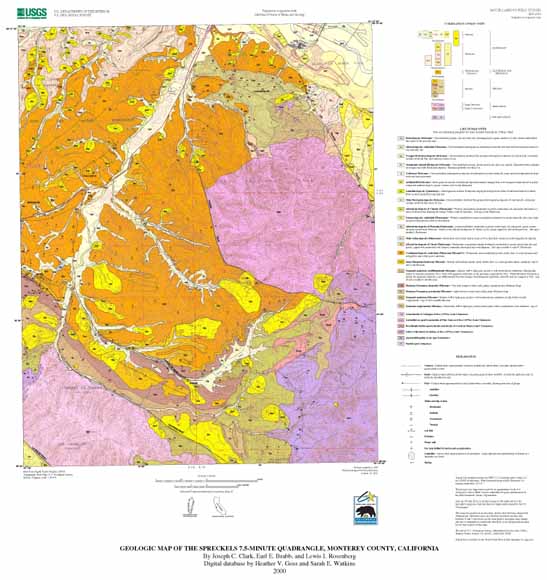
The Spreckels quadrangle lies at the north end of the Sierra de Salinas and extends from the Salinas Valley on the northeast across Los Laurelles Ridge south to Carmel Valley, an intermontane valley that separates the Santa Lucia Range from the Sierra de Salinas. The Toro Regional Park occupies the east-central part of the quadrangle, whereas the former Fort Ord Military Reservation covers the northwestern part of the area and is the probable locus of future development. Subdivisions largely occupy the older floodplain of Toro Creek and the adjacent foothills, with less dense development along the narrower canyons of Corral de Tierra and San Benancio Gulch to the south. The foothills southwest of the Salinas River are the site of active residential development.
Geologically, the study area has a crystalline basement of Upper Cretaceous granitic rocks of the Salinian block and older metasedimentary rocks of the schist of the Sierra de Salinas of probable Cretaceous age. Resting nonconformably upon these basement rocks is a sedimentary section that ranges in age from middle Miocene to Holocene and has a composite thickness of as much as 1,200 m. One of the purposes of the present study was to investigate the apparent lateral variation of the middle to upper Miocene sections from the typical porcelaneous and diatomaceous Monterey Formation of the Monterey and Seaside quadrangles to the west to a thick marine sandstone section in the eastern part of the Spreckels quadrangle.
Liquefaction, which seriously affected the Spreckels area in the 1906 San Francisco earthquake, and landsliding are the two major geological hazards of the area. The landslides consist mainly of older large slides in the southern and younger debris flows in the northern part of the quadrangle.
Files available for downloading:
mf2349a.t.gz A tarred, gzip'd package that contains two PostScript files (skmap.ps and skmf.ps) that make up the map (13.5 MB).
skmap.pdf A PDF file of the map sheet (7.3 MB).
skmf.pdf A PDF file of the accompanying pamphlet for the map (80 kb).
mf2349c.t.gz A tarred, gzip'd package that contains all the Arc/Info coverages that make up the spatial database (including import.aml), a file that describes how to use the database (as both a text-only and PDF file), and the metadata (496 kb).
mf2349d.met.txt An ASCII text file of the FGDC-compliant metadata for this publication (68 kb).
For additional information:
Contact Information, Western Region Geology and Geophysics Science Center—Menlo Park
U.S. Geological Survey
345 Middlefield Road, MS-973
Menlo Park, CA 94025-3591
http://geomaps.wr.usgs.gov/
Clark, J.C., Brabb, E.E., and Rosenberg, L.I. ,2000, Geologic map and map database of the Spreckels 7.5-Minute quadrangle, Monterey County, California: U.S. Geological Survey Miscellaneous Field Studies MF–2349, scale 1:24,000. (Available at https://pubs.usgs.gov/mf/2001/2349/.)
Part of this report is presented in Portable Document Format (PDF); the latest version of Adobe Reader or similar software is required to view it. Download the latest version of Adobe Reader, free of charge.
Last modified June 27, 2012
First posted January 1, 2001

![]() U.S. Department of the Interior |
U.S. Geological Survey
U.S. Department of the Interior |
U.S. Geological Survey
URL: http://pubsdata.usgs.gov/pubs/mf/2001/2349/index.html
Page Contact Information: GS Pubs Web Contact
Page Last Modified: Thursday, 01-Dec-2016 12:07:54 EST
