U.S. Geological Survey Miscellaneous Field Studies MF–2360
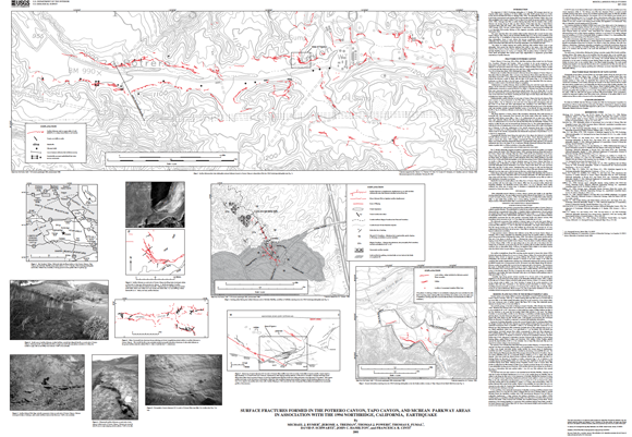
The magnitude 6.7 (M6.7) Northridge earthquake of 17 January 1994 strongly shook the Los Angeles urban region, resulting in 33 direct deaths, more than 20,000 people forced out of their homes, and an estimated $20 billion in damage. The earthquake was caused by slip on a previously unrecognized south-dipping fault buried beneath the San Fernando Valley. Slip on the fault propagated from a depth of about 19 km to about 8 km below the ground surface. Although there was no surface faulting associated with the causative fault, surface fractures did develop along at least one fault (Mission Wells fault) and also in areas without recognized faults. The term “surface fractures” is used herein to describe ground breakage that is not associated with primary faulting or with triggered, secondary, surface faulting on a deep seismogenic fault.
This report describes fault- and nonfault-related surface fractures that occurred at three sites, Potrero Canyon, Tapo Canyon, and the McBean Parkway area, 22 to 28 km north-northwest of the main shock. Investigation of these sites documents far reaching effects of even moderately large earthquakes. Study of such effects has become increasingly important with further urbanization and development. Hecker and others documented the distribution of surface deformation associated with the Northridge earthquake in the Granada Hills area.
The search for surface faulting and surface fracturing was initiated within hours of the earthquake. Both ground and airborne searches were made of the region. After fresh surface fractures were found in Potrero Canyon, aerial photographs were taken of the area (including the McBean Parkway site) by I.K. Curtis, on 21 January 1994, at scales of about 1:2,000 and 1:6,000. These aerial photographs were studied under high magnification to supplement ground-based observations of surface fractures.
For additional information:
Contact Information, Earthquake Science Center, Menlo Park Science Center
U.S. Geological Survey
345 Middlefield Road, MS 977
Menlo Park, CA 94025
http://earthquake.usgs.gov/
Michael J. Rymer, Jerome A. Treiman, Thomas J. Powers, Thomas E. Fumal, David P. Schwartz, John C. Hamilton, and Francesca R. Cintis, 2001, Surface Fractures Formed in the Potrero Canyon, Tapo Canyon, and McBean Parkway Areas in Association with the 1994 Northridge, California Earthquake: U.S. Geological Survey Miscellaneous Field Studies MF–2360, scale 1:4,000. (Available at https://pubs.usgs.gov/mf/2001/2360/.)
Part of this report is presented in Portable Document Format (PDF); the latest version of Adobe Reader or similar software is required to view it. Download the latest version of Adobe Reader, free of charge.
Last modified June 27, 2012
First posted January 9, 2002

![]() U.S. Department of the Interior |
U.S. Geological Survey
U.S. Department of the Interior |
U.S. Geological Survey
URL: http://pubsdata.usgs.gov/pubs/mf/2001/2360/index.html
Page Contact Information: GS Pubs Web Contact
Page Last Modified: Thursday, 01-Dec-2016 12:07:58 EST
