
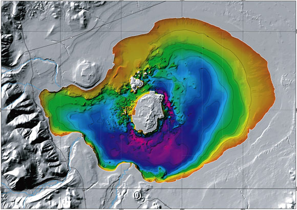
This bathymetric model of Mono Lake shows increasing depths ranging from the shallowest shown in red through shades of orange, green, and blue to the deepest shown in magenta. The surface terrain is shown in tones of gray. The east face of the Sierra Nevada is shown along the left edge of the image. Light blue lines trace the channels of the major creeks providing water form Mono Lake From north to south these are Mill, Lee Vining, Walker, Parker, and Rush Creeks. Larger Paoha (center) and smaller Negit Islands are small dacite volcanoes, as is Black Point (upper left center). Former Ice Age lake shorelines can be seen as irregular, roughly concentric circles surrounding the present shoreline.
In 1986 and 1987, Pelagos Corporation of San Diego (now Racal Pelagos) undertook a bathymetric survey of Mono Lake in eastern California for the Los Angeles Department of Water and Power (DWP). The result of that survey was a series of maps at various scales and contour intervals. From these maps, the DWP hoped to predict consequences of the drop in lake level that resulted from their diversion of streams in the Mono Basin. No digital models, including shaded-relief and perspective-view renderings, were made from the data collected during the survey. With the permission of Pelagos Corporation and DWP, these data are used to produce a digital model of the floor of Mono Lake. The model was created using a geographic information system (GIS) to incorporate these data with new observations and measurements made in the field. This model should prove to be a valuable tool for enhanced visualization and analyses of the floor of Mono Lake.
Files available for download
mf2393.pdf - PDF file containing this report (454 kb).
mf2393.doc - Microsoft Word version of this report (454 kb).
monobathy.zip - Compressed file of bathymetric model in ARC/GRID format (5.2 MB).
monometa.zip - Compressed file of FGDC metadata (13 kb).
mf2393_s1.pdf - PDF file of plottable map, Sheet 1 (15.6 MB).
mf2393_s2.pdf - PDF file of plottable map, Sheet 2 (8.9 MB).
mf2393_s1.zip - Compressed EPS file of plottable map, Sheet 1 (25.1 MB).
mf2393_s2.zip - Compressed EPS file of plottable map, Sheet 2 (61.2 MB).
For questions about the scientific content of this report, contact Christian Raumann (Christian_Raumann@URSCorp.com)
This report is available via print on demand.
| Help
| PDF help |
| Publications main page
| Miscellaneous Field Studies Maps |
| Department of the Interior
| U.S. Geological Survey |
| Geologic Division
| Western Earth Surface Processes Team|
| Privacy Statement
| Disclaimer
| Accessibility |
URL of this page is:
https://pubs.usgs.gov/mf/2002/2393/
Please send comments and suggestions, or report problems, to:
Michael Diggles
Updated: April 24, 2007 (bwr, mfd)