Miscellaneous Field Studies Map 2390
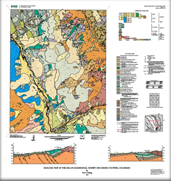 
Abstract New 1:24,000-scale geologic mapping along the Interstate-70 urban corridor in western Colorado, in support of the USGS Central Region State/USGS Cooperative Geologic Mapping Project, is contributing to a more complete understanding of the stratigraphy, structure, tectonic evolution, and hazard potential of this rapidly developing region. The 1:24,000-scale Dillon quadrangle is near the headwaters of the Blue River and straddles features of the Blue River graben (Kellogg, 1999), part of the northernmost reaches of the Rio Grande rift, a major late Oligocene to recent zone of extension that extends from Colorado to Mexico. The Williams Range thrust fault, the western structural margin of the Colorado Front Range, cuts through the center of the quadrangle, although is mostly covered by surficial deposits. The oldest rocks in the quadrangle underlie the Williams Fork Mountains and the ridge immediately east of South Fork Middle Fork River, and include biotite-sillimanite schist and gneiss, amphibolite, and migmatite that are intruded by granite inferred to be part of the 1,667-1,750 Ma Routt Plutonic Suite (Tweto, 1987). The oldest exposed sedimentary unit is the Upper Jurassic Morrison Formation, but Pennsylvanian Maroon Formation, a sequence of red sandstone, conglomerate, and interbedded shale, underlies the southern part of the quadrangle. The thickest sequence of sedimentary rocks is Cretaceous in age and includes at least 500 m of the Upper Cretaceous Pierre Shale. Surficial deposits include (1) an old, deeply dissected landslide deposit, possibly as old as Pliocene, on the west flank of the Williams Fork Mountains, (2) deeply weathered, very coarse gravel deposits underlying a mesa in the southwest part of the quadrangle (the Mesa Cortina subdivision. The gravels are gold bearing and were mined by hydraulic methods in the 1800s), (3) moderately to deeply weathered, widespread, bouldery material that is a combination of till of the Bull Lake glaciation, debris-flow deposits, landslide deposits, and possibly pre-Bull Lake till, (4) glacial deposits of both Bull Lake (middle Pleistocene) and Pinedale (late Pleistocene) glaciations, (5) recent landslide deposits, and (6) extensive colluvial and alluvial deposits. |
Version 1.0 Posted September 2002 This map supersedes Open-File Report 97-738
This text-only version of the map is accessible as defined by Section 508.
|

![]() U.S. Department of the Interior | U.S. Geological Survey
U.S. Department of the Interior | U.S. Geological Survey
URL: http://pubsdata.usgs.gov/pubs/mf/2002/mf-2390/index.html
Questions or Assistance: Contact USGS
Last modified: Thursday, 01-Dec-2016 12:08:21 EST
