By Mark R. Hudson and Kyle E. Murray
Version 1.0
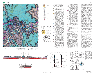
This map summarizes the geology of the Ponca 7.5-minute quadrangle in the Ozark Plateaus region of northern Arkansas.
| The text of this report is presented here in Portable Document Format. Adobe Acrobat Reader™ (5.0 or higher) or similar software is required to view it. If you wish to download the latest version of Acrobat Reader free of charge, click here. |
| MF-2412 PDF file (3.53 MB) | For viewing and printing |
| Text Only PDF file (4.23 MB) | (This version of the report is accessible as defined in Section 508.) |
| |
| Metadata file: | |
| Metadata TXT file (25 KB) | (This version of the report is accessible as defined in Section 508.) |
A high-resolution plot of this map can be purchased from Information Services, U.S. Geological Survey (1-888-ASK-USGS).