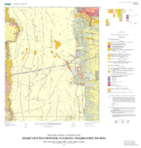
Geologic map of the La Mesita Negra SE quadrangle, Bernalillo County, New Mexico
By Ralph R. Shroba, Ren A. Thompson, Dwight L. Schmidt, Stephen F. Personius, Florian Maldonado and Theodore R. Brandt
Map Sheet 1
Link to PDF (3.5 MB)
Abstract
Geologic mapping, in support of the USGS Middle Rio Grande Basin Geologic Mapping Project, shows the spatial distribution of artificial-fill, alluvial, colluvial, and eolian deposits, lava flows and related sediments of the Albuquerque volcanoes, and upper Santa Fe Group sediments. These deposits are on, beneath, and along the West Mesa (Llano de Albuquerque) just west of Albuquerque, New Mexico. Artificial fill deposits are mapped chiefly beneath and near segments of Interstate 40, in an inactive landfill (or dump) north of Interstate 40 near the eastern boundary of the map area, and in the active Cerro Colorado landfill near the southwestern corner of the map area. Alluvial deposits are mapped in stream channels, beneath treads of terraces, and on hill slopes. They include alluvium in stream channels and beneath treads of low terraces, terrace alluvium, sheetwash deposits, gravelly alluvium, and old alluvium and calcic soils of the Llano de Albuquerque. Alluvial and colluvial deposits are mapped on hill slopes. They include young alluvial-slope deposits, alluvium and colluvium, undivided, and old alluvial-slope deposits. Colluvial deposits are also mapped on hill slopes. They include colluvial deposits, undivided, as well as alluvial deposits, eolian sand, and calcic soils associated with fault scarps. Eolian deposits as well as eolian and alluvial deposits mantle gently slopping surfaces on the Llano de Albuquerque. They include active eolian sand, active and inactive eolian sand and sheetwash deposits, undivided, and inactive eolian sand and sheetwash deposits, undivided. Lava flows and related sediments of the Albuquerque volcanoes were mapped near the southeast corner of the map area. They include five young lava flows, two young cinder deposits, and old lava flows. Upper Santa Fe Group sediments are well exposed and mapped in the western part of the map area. They include a gravel unit, a pebbly sand unit, and a mud and sand unit. Undivided upper Santa Fe Group sediments were mapped in the eastern part of the map area.
Sediments and lava flows in the map area record alluvial, eolian, colluvial, and volcanic processes of the past several million years. The surficial deposits (post-Santa Fe Group sediments) on the map are known or estimated to be at least 1 m thick; most deposits are poorly exposed. Thin (< 50 cm), discontinuous deposits of eolian sand and sheetwash (Qea, Qes, and Qsw) locally are present on gently sloping map units older than the alluvium in stream channels and low terraces (Qa). These thin eolian and sheetwash deposits are...>>MORE
Version 1.0
Posted October 2005
Pamphlet PDF (175 KB) (This version of the report is accessible as defined in Section 508 of the Rehabilitation Act of 1973, Amendments of 1998.)
It is best to download a large file to your hard drive rather than open it inside your browser. A standard click may automatically open the PDF file inside the browser but doing so will result in a very slow load. Downloading the file may take several moments but will be worth the wait. Once it is downloaded, open it from your hard drive—it will open in a fraction of the time it would take to open over the Internet.
ArcInfo export files and ArcView shapefiles (mf-2416); georeferenced topographic base map (mf-2416topo); and the georeferenced shaded-relief base map (mf-2416hlshd). Each are contained in a gzipped tar archive or zip archive.