|
|
Introduction
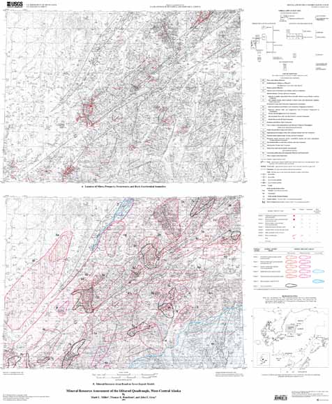
The mineral resource assessment of the Iditarod quadrangle is the final product of a multi-year effort by the U.S. Geological Survey in cooperation with the Alaska Division of Geological and Geophysical Surveys. The report is divided into sections beginning with summaries of the geology, geochemical databases, and available geophysical information. The geology is summarized from Miller and Bundtzen (1994), an earlier product of this cooperative study. The primary geochemical databases considered for this assessment are analyses of rock (McGimsey and others, 1988) and drainage basin samples (stream sediment, heavy-mineral concentrate, and aquatic moss) collected in the course of this study. The drainage basin data are summarized in three maps that show the distribution of samples containing anomalous concentrations of various metallic elements (Gray and others, 1997a, c, and d). No new geophysical data were collected during the course of this cooperative study; however, a summary of available data is provided. A comprehensive, descriptive summary of the mines, prospects, occurrences, and significant rock geochemical anomalies of the Iditarod quadrangle forms a critical component of this report. These descriptions are based on historical information provided in published government reports, unpublished mint records, and documented oral historical accounts given by local miners, supplemented by new geologic and geochemical data from this study. The descriptions are provided in a table format (table 1); locations are given on map A. Also summarized in the table are the new mineral occurrences discovered during the course of this work. The metallic resource assessment, which is based on all the above data, forms the main body of this report. It departs from other resource assessments by presenting the data in two different ways. On map B, forty-six mineral resource areas are outlined on the basis of seven deposit models and assigned high, moderate, or low potential for discovery of additional deposits. This map is the basic tool for evaluating the undiscovered resources of the area and shows which areas are prospective for specific commodities. A detailed description of each of the forty-six areas is provided in the text. Another way to summarize the assessment is in terms of the total mineral endowment, that is, all metallic commodities combined (fig. 3). This view would be more useful in land-planning decisions, as it better predicts where future mining might take place. The final section of the report is a discussion of the non-metallic resources of the quadrangle including oil and gas, coal, sand and gravel, and rip rap; however, no specific resource areas or tracts are outlined. This section includes a summary of new vitrinite data, which confirm that it is unlikely the Iditarod quadrangle holds any oil or gas reserves. |
Download this map as a ~36" x 43" PDF file (mf2219b_map.pdf; 2.8 MB)
Download this accompanying pamphlet as a 100-page PDF file (mf2219b_pamphlet.pdf; 2.3 MB)
For questions about the content of this report, contact Marti Miller
|
Help |
PDF help |
Publications main page |
This report is also available in paper form from:
USGS Information Services, Box 25286,
Federal Center, Denver, CO 80225
telephone: 888-ASK-USGS (888-275-8747); e-mail: infoservices@usgs.gov
ISBN: 1-411-30886-7