Miscellaneous Field Studies Map 2417
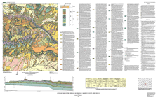 
The 1:24,000-scale geologic map of the Pinedale 7.5' quadrangle lies in the western part of the Grants uranium mineral belt, which was mapped and studied under a cooperative agreement between the USGS and the U.S. Department of Energy. A spectacular panoramic view of the southern half of the Pinedale quadrangle is obtained looking northward from Interstate Highway 40, particularly from the New Mexico State travelers' rest stop near the Shell Oil Company's Ciniza Refinery, 28.5 kilometers (17.8 miles) east of Gallup. A west-trending escarpment, 200 meters high, of massive red sandstone, rises above a broad valley, its continuity broken only by a few deep and picturesque canyons in the western half of the quadrangle. The escarpment is formed by the eolian Entrada Sandstone of Late Jurassic age. The Entrada unconformably overlies the Chinle Formation of Late Triassic age, which occupies the valley below. The Chinle Formation consists of cherty mottled limestone and mudstone of the Owl Rock Member and underlying, poorly consolidated, red to purple fluvial siltstone, mudstone, and sandstone beds of the Petrified Forest Member. The pinyon- and juniper-covered bench that tops the escarpment is underlain by the Todilto Limestone. A quarry operation, located just north of the Indian community of Iyanbito in the southwestern part of the quadrangle, produces crushed limestone aggregate for highway construction and railroad ballast. Beyond the escarpment to the north and rising prominently above it, is the northwest-trending Fallen Timber Ridge. Near the west side of the quadrangle lie the peaks of...>> MORE |
(This text-only PDF (105 KB) version of the report is accessible as defined in Section 508 of the Rehabilitation Act of 1973, Amendments of 1998.)
|
Part or all of this report is presented in Portable Document Format (PDF); the latest version of Adobe Acrobat Reader or similar software is required to view it. Download the latest version of Acrobat Reader, free of charge or go to access.adobe.com for free tools that allow visually impaired users to read PDF files.

