
Core OL-92 from Owens Lake, southeast California
Sediment pore-waters of Owens Lake Drill Hole OL-92
- James L. Bischoff
- Jeffrey P. Fitts
- U.S. Geological Survey, Menlo Park, California
- Kirsten M. Menking
- Earth Sciences Board, University of California, Santa Cruz
Contents:
Abstract
The salinity-depth profile of pore-waters from the Owens Lake drill hole
OL-92 has been drastically smoothed by post-depositional diffusion of
dissolved salts and ground water flow, such that the present pore water
composition bears little relationship to past climate. Water content
varies erratically down the core, generally decreasing from about 60 wt %
at the top to about 20 wt % at 240 m, but water content increases sharply
at levels below 240 m to between 40-60 wt %, indicating significant
undercompaction for the lowermost 100m. The pore waters are alkaline (pH
8-10) with anionic compositions of HCO3»Cl>SO4 which is similar to the
chemistry of the modern lake before diversion of the source waters. The
pore water salinity ranges from 0.4 to 5 wt % TDS. Salinity varies with
depth in a smooth pattern with a minimum at 30 m, gradually increasing to
a single broad maximum at about 150 meters depth, and declining sharply
thereafter to steady low values at 210 meters and below where ground water
is apparently flowing at present.
Introduction
During the spring of 1992, a 323 m core (7.6 -cm diameter) was recovered
from Owens Lake in order to obtain a record of climate history and natural
climate variation. Drilling was carried out in three sub sections: from
the surface to 7.16 m (OL-92-3), from 5.49 to 61.37 m (OL-92-1) and from
61.26 to 322.86 m (OL-92-2), together representing about 800 kyr of
sedimentation (Smith, 1993). Sediments were analyzed for grain size,
major elements, carbonate, organic carbon, cation-exchange capacity,
radiocarbon, and pore-water composition, in order to monitor climatic
changes and place them in a temporal context. We report here on the pore
water content and composition of samples from the core. The companion
article by Friedman et al (1993) reports deuterium/hydrogen ratios on the
same samples. Results for other sediment-parameters are reported in
other companion articles (Bischoff et al 1993a and 1993b; Menking et al
1993a and 1993b)
Sampling procedures
Samples of fresh wet sediment (60 cc) for the determination of water
content and pore water chemistry were taken during the drilling operations
at every 2-3 m from clay-rich horizons for the entire length of the core
(120 samples). The samples were taken in the field from the freshly split
core within minutes of exposure of the fresh sediment. Each sample was
trimmed of disturbed sediment adjacent to the core liner, and immediately
sealed within a 75 ml air tight glass bottle and kept refrigerated at 5°C
until laboratory processing some three months later.
Laboratory Procedures
For the determination of water content, 1 to 2 cc splits of the fresh
sediment were weighed into ceramic crucibles and their weight loss
recorded after heating for two days at 100°C. Water content as weight per
cent is simply the percentage of weight loss of the sediment. The
remaining sample was transferred into a stainless steel cylindrical
squeezer (modified after that of Manheim, 1966) which was then pressurized
with a simple laboratory hydraulic press (12 ton capacity). The pore
water squeezed from the sediment passed through three layers of filter
paper and into a polyethylene syringe. Squeezing for 10 to 30 minutes
yielded from 3 to 25 ml of pore water, depending on the water content of
the sample. The sample was then passed through a swinney-mounted membrane
filter (0.45 µm pore size). Two drops were used for immediate measurement
of refractive index for salinity, a 1 ml aliquot was used for immediate pH
determination by micro electrode, 1-2 ml were injected into a septum-
capped evacuated blood tube for isotopic analyses, and the remainder
stored in a tightly-capped polyethylene bottle for further chemical
analyses. Ct (total dissolved inorganic carbon) was determined by an
infrared CO2-analyzer. Cl was determined by potentiometric titration with
an auto-titrator, and sulfate concentration was determined by ion
chromatography. The remaining sediment cake was retained for analyses of
organic C, carbonate, and grain size as reported in the companion reports
by Menking et al (1993a) and Bischoff et al (1993a).
Data and discussion
Results are presented in Table 1. Water content,
the measure of compaction, varies erratically down the core, generally
decreasing from about 60 wt % at the top to about 20 wt % at 240m
(Table 1, Figure 1). Below 240 meters and to the
bottom of the core the water content sharply increases to between 40 and 60
percent by weight. This zone is characterized by an abundance of sandy units
(Smith, 1993). Salinity varies with depth in a smooth pattern (Table 1,
Fig. 1) with a minimum at 30 m, gradually increasing to a single broad
maximum at about 150 meters depth, and sharply declining thereafter to steady
low values at 210 meters and below. The salinity of the modern lake (1872)
prior to agricultural activity in the water shed, was about 9% (Gale, 1914).
Assuming that similarly elevated salinity characterizes the various
interglacial times when Owens Lake was the terminus, and that fresh waters
must have characterized the glacial periods of intense overflow, one might
expect about 8 salinity oscillations during the 800 kyr time span of the
core. Such cycles are seen in the solid components of the sediments,
particularly for carbonate and organic carbon content (Bischoff et al,
1993a) indicating the lake did indeed experience such changes. The
salinity-depth profile, therefore, has been drastically smoothed by post-
depositional diffusion of dissolved salts. Remnant waters of the last
interglacial are the likely explanation only for the first salinity
minimum seen at 30-40 m depth. The smooth and gradual increase of
salinity in the older sediments below this depth to a maximum at about 150
m is likely the result of diffusional smoothing of older cycles.
Diffusion should have had more than sufficient time, therefore, to smooth
salinity gradients even lower in the core. The abrupt and erratic
decrease of salinity from 150 to 210 m depth, and the erratic and
generally low salinities from 210 to the bottom of the hole points to an
open system for the basal pore fluids. The most likely explanation for
this pattern is that fresher waters are actively moving through the sandy
units below 200 m, diffusionally harvesting salt from the overlaying fine-
grained sediments in the process. This ground water is moving at
different velocities in the varyingly permeable sandy units, and
diffusional steady state and smoothing of the salinity gradients has not
been achieved.
The pre-1872 water of Owens Lake was characterized by an anionic
composition of Cl:Ct:SO4 about 47:47:6 (mole basis), and Na was the only
significant cation (Gale, 1914). With a salinity of about 9% the lake was
alkaline and must have had a pH on the order of 10. The average pore
water of the sediment, on the other hand, has pH between 8 and 10, a
salinity of only 2.7%, and the anionic proportions are Ct:Cl:SO4 of 52:45:3.
The pore water, therefore, is similar in Ct:Cl to the modern lake, but
has a lower salinity and a reduced proportion of SO4, a consequence of the
activity of sulfate reducing bacteria that produce the abundant iron
monosulfides which blacken the fine grained sediments A
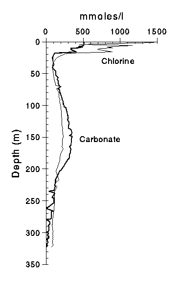
depth plot of Ct and Cl (Fig. 2) shows that the relative proportions of
the two change with depth. The extremely high salinity of the top 20 meters
is not a reflection of the modern (pre-1872) lake. Rather, it is a consequence
of almost complete desiccation of the lake in 1912 and the downward migration
of the more dense residual-brines. As the lake dried Na carbonate
minerals precipitated resulting in the 1 to 2 m thick salt bed at the
surface today, and the residual brine became relatively enriched in Cl.
This residual brine then percolated downward by gravity displacement and
ionic diffusion, affecting the pore water composition down to about 15 m
and explaining the reversal in the Ct/Cl ratio as observed in Fig. 2.
There is neither sedimentological nor mineralogical evidence in the entire
length of the core that such concentrations of brine and precipitation of
saline minerals had been attained before. Below about 50 meters depth
both Ct and Cl increase in a smooth pattern. At 40 m, Ct and Cl are
about equal as they were in the pre-1872 lake. Below this depth the Cl
pattern is more spread out than Ct, and in the region of the salinity
maximum at 150 m, Ct exceeds Cl, while in the low salinity region below
240 m Cl exceeds Ct. The pattern is most readily explained by relative
diffusivity of Cl and HCO3. With a decreasing salinity gradient in both
directions from the maximum at 150 meters, Cl and HCO3 are diffusing from
this maximum both downward and upwards. The coefficient of ionic
diffusion for Cl is twice that for HCO3 (2.3 x10⁻⁵ versus 1.18 x 10⁻⁵ cm2
sec-1; Li and Gregory, 1974) so it is to be expected that Cl transport
away from the salinity maximum will be about twice the rate of HCO3
transport.
The present pore water composition, therefore, bears little relationship
to past climate because depth profile has clearly been smeared by post-
depositional diffusion of dissolved salts, and modern flow of ground
waters. Deuterium/hydrogen ratios in the pore-waters led Friedman et al
(1993) to essentially the same conclusions.
Tables
-
Water content and pore water composition of sediments from OL-92.
Water content and salinity in wt %. Cl, Ct (total dissolved CO2), and SO4
in millimolal (mm). Absence of data entry indicates component was not
analyzed.
Figures
- Sediment water-content and pore-water salinity variation with depth in
Owens Lake drill hole OL-92. (PostScript version)

- Pore-water Cl and Ct (total dissolved carbonate species) concentration
with depth in Owens Lake drill hole OL-92. (PostScript version)
References
- Bischoff, J.L., Fitts, J. P., Fitzpatrick, J.A.. and Menking, K. (1993a) Sediment Geochemistry of Owens Lake Drill Hole OL-92. U.S. Geological Survey Open-File report 93-683
- Bischoff, J.L., Stafford, T. W., and Rubin, M. (1993b) AMS radiocarbon dates on sediments from Owens Lake drill hole OL-92. U.S. Geological Survey Open-File report 93-683
- Friedman, Irving, Johnson, Craig, and Smith, G.I. (1993) Deuterium-hydrogen ratios of interstitial fluids from Owens Lake core OL-92. U.S. Geological Survey Open-File report 93-683
- Gale, H.S. (1914) Salines in the Owens, Searles, and Panammint basins southeastern California. U.S. Geological Survey Bulletin 580-L, p. 251-323.
- Li, Yuan-Hui and Gregory, S. (1974) Diffusion of ions in sea water and in deep-sea sediments. Geochimica et Cosmochimica Acta, v. 38, pp. 703-714
- Manheim F.T (1966) A hydraulic squeezer for obtaining interstitial water from consolidated and unconsolidated sediments: U.S. Geological Survey Prof. Paper 550-C, p. 256-261.
- Menking, K., Musler, H.M., Fitts, J.P., Bischoff, J.L., and Anderson, R.S. (1993a) Sediment size analyses of the Owens Lake core. U.S. Geological Survey Open-File report 93-683
- Menking, K., Musler, H.M., Fitts, J.P., Bischoff, J.L., and Anderson, R.S. (1993b) Clay mineralogical analyses of the Owens Lake core. U.S. Geological Survey Open-File report 93-683
- Smith, G.I. (1993) Core OL-92. U.S. Geological Survey Open-File report 93-683
U.S. Department of Interior, U.S. Geological Survey
URL of this page: https://pubs.usgs.gov/openfile/of93-683/4-geochem/2-pore-water/pore-water.html
Maintained by: Eastern Publications Group Web Team
Last modified: 03.01.01 (krw)