
Exploratory Analysis of Environmental Interactions in Central California
by Lee De Cola and Neil Falcone
United States Geological Survey, 521 National Center, Reston VA 22092
(ldecola@usgs.gov)
United States Geological Survey Open-File Report 95-654
1995/10/23
 DISCLAIMER
Although this electronic document has been carefully developed and edited, it may contain features that your web browser or computer will not be able to display. If you want to check capabilities available to you, click here.
Any use of trade, product, or firm names in this publication is for descriptive purposes only and does not imply endorsement by the U.S. Government.
Contents
As part of its global change research program, the United States Geological Survey (USGS) has produced raster data that describe the land cover of the United States using a consistent format. The data consist of elevations, satellite measurements, computed vegetation indices, land cover classes, and ancillary political, topographic and hydrographic information. This open-file report uses some of these data to explore the environment of a (256-km)² region of central California. We present various visualizations of the data, multiscale correlations between topography and vegetation, a path analysis of more complex statistical interactions, and a map that portrays the influence of agriculture on the region's vegetation. An appendix contains C and Mathematica code used to generate the graphics and some of the analysis.
This Open-File Report is one of the first electronic documents to be produced by the USGS on
Mosaic
(Schatz and Hardin, 1994). Its purpose is to explore the various features of this new communications medium, to introduce a useful data series to the earth science community, and to use some of these data to explore geographic relationships. We suggest that you scan the document now to see what it contains, and select a few of the links that may be of interest to you. Then follow the text by selecting each link as you go along. If you have any comments, please send them to the address above.
For 175 years the USGS has been mapping the Nation's landscape, from topography and geology, to hydrography, land cover and cultural features. But with a growing concern about the environment the USGS has expanded its role by mapping dynamic changes in global land cover (Kineman in Goodchild and others, 1993). The
EROS Data Center
(EDC) distributes much of these data sets on
CD-ROM's
as part of a growing series of discs, each of which contains more than 500,000,000 bytes (1/2 gigabyte) of data (Eidenshink, 1992).
The conterminous United States advanced very high resolution radiometer (AVHRR) data set series describes the land cover of the 48 States. The data use a consistent format of 1-km cells organized into 4,587 columns and 2,889 rows = 13,251,843 cells or more than 13 megabytes. These data sets are on three types of discs:
- Biweekly composite AVHRR data CD-ROM's (five per year for the years 1990-94);
- Companion CD-ROM containing ancillary data (boundaries, elevation, and so forth);
- Prototype
land characterization
CD-ROM presenting land cover images.
Each CD-ROM consists of document files in text format, image data, and labels for the data, all organized in a hierarchical directory structure. The document files contain complete descriptions of the data and specifications to read the data and use them in research. For example, the 3 discs used in this study contain
97 files
totaling more than 1.5 gigabytes of image data alone. These data are coregistered to the same projection so that each pixel corresponds to the same location in space from image to image.
One of the most useful data sets in the land characterization disc is the USGS Level II
land cover
image for the continental United States. This image is the result of taking multiple satellite images over multiple dates and using these data to classify the surface of the Nation into
26 classes
of land cover, ranging from agricultural and forest types to desert and tundra. (This legend will be used again below.) We have used these data to develop multiple views of a study area in California.
The land cover image of the United States reveals that the country is extremely diverse, showing a variety of topographic, climatic, and landscape zones. Perhaps no region manifests this diversity more than the State of
California,
which contains nearly all the ecological zones of the country: desert, savannah, cropland, forest, and wetland (Knox and Scheuring, 1991). In this image we see the State extracted from the
26-class
data set shown earlier for the United States.
Throughout most of the history of the United States the
central California
region has grown in population, but development has been most rapid since World War II. In fact, this region once again (as in the 19th century) rivals southern California in its size and diversity. To understand this changing complexity, researchers at the USGS began a research program investigating human-induced land transformations (HILT) in various parts of the Nation, beginning with the Bay Area of California. The major products of the HILT research program are:
- A geodynamic
animation
of the growth of urbanization in the central California (Acevedo, 1994);
- An interactive
simulation
model that can be used to project current land use patterns into the future;
- An analysis of environmental interactions in the
central California
region (this study).
This research examines correlations among environmental measurements for central California in order to determine causal factors explaining current land use patterns in the region. We have chosen for detailed study a (256-km)² region we call the SanSac geopolitical region because it includes SAN Jose, San Francisco, and SACramento. This region includes not only these urban growth points but also much of the Central Valley, which is also experiencing rapid growth (Teitz, 1991). This region manifests much of the environmental complexity of the State of California and includes the largest concentration of people in the northern part of the State. A
map
of the area shows relief, county boundaries, and major streams. The diversity of the SanSac region makes it an ideal laboratory for large-scale environmental research.
One goal of the USGS global change research program is to facilitate the use of USGS spatial data to monitor, analyze, and predict land cover change in the United States (Kirtland and others, 1994). In particular, this research uses the AVHRR and related data to describe human-induced land cover change within a
feature-space
defined by time, space, and resolution. One challenge of this process is that scientists need to explore ways of managing and analyzing data at multiple
scales
(De Cola and Buttenfield, 1994).
The focus of the AVHRR data acquisition program is the mapping of greenness or normalized difference vegetation index (NDVI) at a continental scale. The satellite measures the reflectivity of the land for 1.1-km pixels at seven wavelengths. Although an image of a large region often appears to be of photographic quality, the discrete nature of such data is apparent when viewed, as here, for
8-km pixels.
When we have mapped and visualized a phenomenon, we become more interested in the underlying physical causes of a given pattern, in this case, of the form vegetative land cover. Two obvious determinants of vegetation are
topography
and climate. We focus here on the nature of the link between elevation and NDVI. One way to visualize this association is by
draping
greenness on elevation. It is also possible to examine the influence of scale on these interactions. By constructing a data
pyramid
in which the
elevation
measurements are successively aggregated, we can look at the topography of the region at different resolution levels.
Multiscale visualization helps us see more clearly the physical scales at which environmental correlations are important. We can also see how such correlation is scale-dependent. Consider, for example, the scatter diagrams of NDVI and the logarithm of elevation change at various resolutions:
- 64-kilometer
data show a very strong positive correlation between elevation and vegetation, from which we conclude that greenness is much stronger at higher altitudes,
- 16-kilometer
data suggest that the correlation is much weaker at larger physical scales,
- 4-kilometer
data reveal interesting nonlinearities in the association, there is at least a third degree process visible, and
- 1-kilometer
data scatter is somewhat confused but does highlight, for example, a cluster at around 100 meters elevation.
This preliminary analysis of the association between elevation and vegetation illustrates that a satisfactory understanding of the determinants of land cover must include some of the additional factors that influence vegetation intensity. The next section explores these ideas.
We have seen that
topography
is an important determinant of vegetation land cover, but also important are other environmental factors such as
climate
(itself influenced by topography) and human
development
(particularly agriculture, forestry, and urbanization). The various elements of this model were assembled into a data
pyramid
by means of a system of various
transformations,
using several tools and techniques so that they all correspond to the same region in space at the same resolution.
These various factors have been organized into a
path
model that interrelates them according to a system of hypothetical
interactions
(De Cola, 1992). This system allows us to estimate several
regression
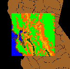
models that predict the influence of each factor on the others. A map of the
residuals
from one of these regression analyses demonstrates the extent to which human activities--and especially agriculture--have profoundly altered vegetation land cover in the region.
We used these data to explore three concepts: multiscale correlation between topography and vegetation; multivariate relationships among topography, climate, human development, and vegetation; and the mapping of human impacts upon the vegetation of the region. We find:
- Interactions among data sets are scale-dependent.
- Topography and climate influence vegetation in a way that corresponds to known environmental processes.
- Human settlement has a nonlinear effect on vegetation (an interpretation of this analysis is that human development in SanSac has generally increased vegetation through agricultural activities, but that intense urbanization diminishes vegetation).
- These statistical patterns can be mapped to visualize, for example, the effect of agriculture on land cover.
This exploration of AVHRR data suggests the breadth of data that are now available to geographic researchers. It also illustrates the application of well-established techniques (data exploration and regression) to the exploration of important regional questions about the impact of human activities on the environment. Finally, it uses the tools of a new technology--networked computers, hypertext, and visualization--to help us understand human-induced land transformations.
 Mapping Information Publications Page
USGS Open-File Reports Page
Mapping Information Publications Page
USGS Open-File Reports Page
URL: http://mac.usgs.gov/mac/isb/pubs/ofrs/95-654/
Maintainer: ldecola@usgs.gov
Last modified: 10SEP96 dec