|
![[ Link to USGS home page ]](images/wrcmgbnr.gif)
Torresan, M.E., Hampton, M.A., Gowen, M.H., Barber, Jr., J.H., Zink,
L.L., Chase, T.E., Wong, F.L., Gann, J.T., and Dartnell, P., 1995, Final
report: acoustic mapping of dredged material disposal sites and deposits
in Mamala Bay, Honolulu, Hawaii: U.S. Geological Survey Open-file Report
95-17.
|
|
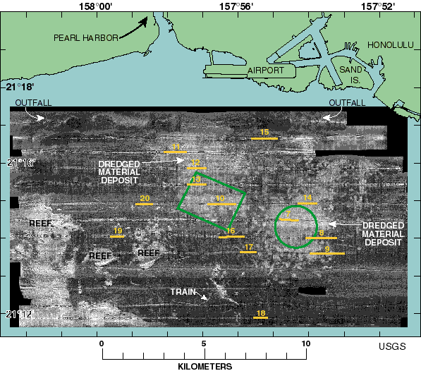
Figure 6. Sidescan sonar mosaic and interpretive map of Mamala Bay. Yellow lines with
numbers over them refer to locations of 3.5-kHz profiles shown in figures 7-20. Note the
circular to subcircular, high-backscatter footprints that coalesce to form two high-
backscatter blankets in the central portion of the mosaic. The deposit located in the upper
central portion of the mosaic, is rectangular in shape, and comprises both the former Pearl
Harbor disposal site and the active South Oahu disposal site. The plume-shape, high-
backscatter deposit located on the east side of the mosaic delimits the former Honolulu
Harbor and 1972 disposal sites. The green, rectangular-shape box in the center of the
mosaic defines the boundary of the active South Oahu disposal site, and the green circle
over the plume-shape deposit on the east side of the map defines the boundary of the
former Honolulu Harbor disposal site. Note how the dredged material deposits extend well
beyond the disposal site boundaries when compared to figures 2-4. The high-backscatter
features located on the southwest side of the mosaic are submerged reefs and not dredged
material deposits.
Click on any yellow line to see a 3.5-kHz profile. (Files are about 100kb.)
URL:
https://pubs.usgs.gov/of/1995/of95-017/fig06.html
Maintained by: Michael Diggles
Author: Florence L. Wong
Last modified: September 13, 2005 (mfd)
|
![[Reports]](images/nav_rprt.gif)
![[Honolulu]](images/nav_hono.gif)
![[Home]](images/nav_home.gif)
![[Search]](images/nav_srch.gif)
