
1U.S. Geological Survey, Flagstaff, Ariz.
2Sedona, Ariz.
3U.S. Geological Survey, Denver, Colo.
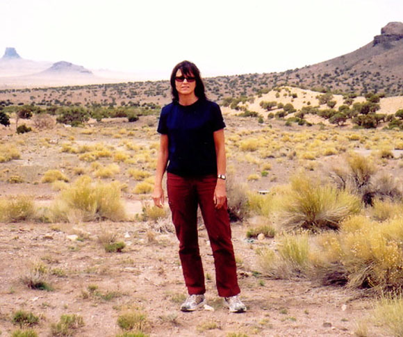
The arid lands surrounding USGS geologist Hiza Redsteer are typical of areas where wind is one of the major erosional forces at work. Note the sand dune behind Dr. Redsteer that is partly stabilized by vegetation. It is an irony that the buttes in the background undergoing wind erosion are composed of fossilized sand dunes nearly a quarter of a billion years old. Photograph by Klara Kelley.
The primary purpose of the Desert Winds Project (DWP) is to obtain high-resolution meteorological data and related surface geological and vegetation data for natural (e.g., uncultivated) desert sites where wind is or has been a major erosive or depositional force. The objectives are twofold: (1) to provide the detailed field measurements needed to carry out quantitative studies of wind as an agent of surface geologic change; and (2) to establish a baseline for defining the "normal" range of climatic conditions that can be expected to occur on a decadal time scale, in areas considered representative of the major American deserts. The Gold Spring locality was selected to represent that part of the Great Basin Desert that extends into northeastern Arizona. The long-term goal for acquiring and analyzing the Desert Winds Project data is to use them to address problems of land resource degradation by wind, whether resulting from climatic variation aridification or human activities (desertification), or both.
Files available for download:
Note: For users who do not have the CD-ROM, the data are available online as described below. This report contains about 48,000 files. The full data set requires over 104 MB of disk space to store. Individual data files are slightly larger than 24 kbytes in size, 242 lines long, and 100 characters (16 data columns) wide.
Documentation (124 kb).
Data folder (104.2 MB).
Software folder (512 kb).
Readme.txt - Details about this report and its directory structure (20 kb).
For questions about the scientific content of this report, contact Paula J. Helm
Download a free copy of Adobe Reader
This report is also available on CD-ROM from:
USGS Information Services
Box 25286 Federal Center
Denver, CO 80225
Telephone: 1-888-ASK-USGS
E-mail: infoservices@usgs.gov
| Help
| PDF help |
| Publications main page
| Open-file Reports for 1995|
| Department of the Interior
| U.S. Geological Survey |
| Geologic Division
| Earth Surface Processes Team |
| Privacy Statement
| Disclaimer
| Accessibility |
URL of this page is:
https://pubs.usgs.gov/of/1995/of95-078/
Please send comments and suggestions, or report problems, to:
Michael Diggles
Created: March 19, 1999
Updated: May 7, 2007 (bwr)