
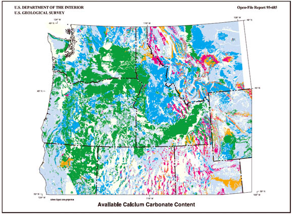
This map shows the availability of calcium carbonate in the rocks of the Pacific Northwest states. The blue and green colors indicate less than average amounts of this compound available while oranges and reds indicate more than average amounts of the chemical available.
The scope and extent of a project area varies depending on the objective. The broad scientific assessment considers all lands, not just those that are federally managed. It is focused on the Columbia River Basin, but is not strictly limited to the actual drainage basin boundaries. Some scientific assessment staff areas have extended their work beyond the formal project area because factors such as wildfires and wildlife migration are not limited to drainage divides or political boundaries. Most staff areas use the Landscape Characterization boundary developed by the Landscape Ecology group. The broad assessment uses information suitable for compilation at a scale of 1:1,000,000.
The rocks of the earth are the ultimate source of all components of living organisms. These components are ultimately chemical elements. Certain chemical elements are required by living organisms, while these same elements can also be poisonous to living organisms. Some elements, such as calcium, are essential to some organisms and can modulate the hazards of other elements, such as heavy metals or acid water. The understanding and application of these processes is complex and not discussed here.
As an example of the maps in this report, the calcium carbonate map (reduced version shown above) was prepared to show the distribution of this important chemical element for fish and their environment. Calcium appears to be important in many ways in the growth and population dynamics of fresh water flora and fauna. A second application of this map is for consideration of potential for buffering acid waters. Calcium carbonate is a primary natural buffering agent for acid drainage from mineralized areas. The major concentrations of calcium carbonate are in areas of limestone, which is a precipitate of calcium carbonate. An additional significant regional source of biologically available calcium carbonate comes from weathering of calcium rich glass, pyroxene, and feldspar in the basalt of the Columbia River Plateau. Basalt in semi-arid environments is characterized by thick accumulations of caliche (calcium carbonate) in the deeper soil horizons. Calcium carbonate is an important factor in the environment and is available in varying amounts from many types of rocks.
Derivative maps produced from state map scale geology are an appropriate first step to providing a regional framework for land management decisions. The applications these maps are intended to address are very general and they should be considered only one component for evaluation of habitat. The scale of the data is appropriate to regional applications concerning the entire Columbia River Basin. Although some of the state geologic maps are as old as the mid-1950's, much of the evolution of geologic knowledge since the 1970's has been concerned with the temporal correlation of rock units, with details of the compositions of the individual units, and with how the existing arrangement of rock units came to exist. These types of information have little bearing on the derivative maps presented here. Thus, the most abundant lithology characteristic of the rock units is well represented in the state geologic maps and the maps are appropriate to regional applications. Similar maps made from more detailed or more up to date geologic information can be prepared at larger scale for watershed analyses projects. Fundamental geologic information is a critical portion of any ecosystem study and should be part of the basis for land management decisions. Future ecosystem monitoring and adaptive management planning within the Columbia River Basin should include improvements in the quality of the geologic database.
Files available for downloading:
View README file: (1.3 kb)
Download Open-File Report 95-685 as a PDF file (5.4 MB).
Download the Primary Datasets in compressed Arc/Info Export format (**.e00.Z):
Base metal data set (19.8 MB download file, 65 MB uncompressed).
Calcium carbonate data set (17.9 MB download file, 59.1 MB uncompressed).
Iron-Magnesium-Aluminum data set (20 MB download file, 66.1 MB uncompressed).
Phosphate data set: (317 kb download file, 1 MB uncompressed).
Potassium data set: (16.7 MB download file, 55.1 MB uncompressed).
Download tables with the description of the map units for the State geologic maps in compressed tar format (*.tar.Z) and includes 8 Arc/Info Export format INFO files (**tbl.e00). The download file is 101 kb, 481 kb uncompressed.
Download Additional Datasets needed to re-create the paper map in a GIS. This file is in UNIX compressed tar format (**.tar.Z) and includes 3 coverages in Arc/Info Export format (study area boundaries, state boundaries within the study area, and 1:2M lat/long corner tics). The download file is 145 kb, 311 kb uncompressed.
Download Text and AML files needed to re-create the paper map in a GIS. This file is in UNIX compressed tar format (**.tar.Z) and includes 12 ASCII files (Arc/Info plot AMLs, key files, and explanatory text). The download file is 13 kb, 28 kb uncompressed.
Download maps prepared from the digital datasets, in compressed (**.hp.Z) HPGL2 format:
Bedrock base-metal content map (2.2 MB download file, 4.2 MB uncompressed HPGL2).
Bedrock calcium carbonate content map (2 MB download file, 3.9 MB uncompressed HPGL2).
Bedrock iron-aluminum-magnesium content map (2.2 MB download file, 4.3 MB uncompressed HPGL2).
Bedrock phosphate content map (92 kb download file, 183 kb uncompressed HPGL2).
Bedrock potassium content map (2 MB download file, 3.7 MB uncompressed HPGL2).
Note: The map scale is 1:2,000,000. Page size is approximately 29 by 38 inches. The maps are oriented with the long axis in the x-direction for plotting. This map was designed to be plotted on a HP Inkjet Plotter (model 650-C), but can be plotted on any full-color (inkjet or electrostatic) plotter which will accept HPGL2 code.
For questions about the scientific content of this report, contact Gary Raines
Download a free copy of Adobe Reader
This report is also available in printed format from:
USGS Information Services
Box 25286 Federal Center
Denver, CO 80225
Telephone: 1-888-ASK-USGS
E-mail: infoservices@usgs.gov
| Help
| PDF help |
| Publications main page
| Open-file reports [on line] |
| Department of the Interior
| U.S. Geological Survey |
| Geologic Division
|Western Mineral Resources|
| Privacy Statement
| Disclaimer
| Accessibility |
The URL for this page is: https://pubs.usgs.gov/of/1995/of95-685/
Please send comments and suggestions, or report problems, to:
Michael Diggles
Updated: May 2, 2007 (bwr, mfd)