National Water-Quality Assessment (NAWQA) Program
The mission of the U.S. Geological Survey (USGS) is to assess the quantity and quality of the earth resources of the Nation and to provide information that will assist resource managers and policymakers at Federal, State, and local levels in making sound decisions. Assessment of water-quality conditions and trends is an important part of this overall mission.
One of the greatest challenges faced by water-resources scientists is acquiring reliable information that will guide the use and protection of the Nation's water resources. That challenge is being addressed by Federal, State, interstate, and local water-resource agencies and by many academic institutions. These organizations are collecting water-quality data for a host of purposes that include: compliance with permits and water-supply standards; development of remediation plans for specific contamination problems; operational decisions on industrial, wastewater, or water-supply facilities; and research on factors that affect water quality. An additional need for water-quality information is to provide a basis on which regional- and national-level policy decisions can be based. Wise decisions must be based on sound information. As a society we need to know whether certain types of water-quality problems are isolated or ubiquitous, whether there are significant differences in conditions among regions, whether the conditions are changing over time, and why these conditions change from place to place and over time. The information can be used to help determine the efficacy of existing water-quality policies and to help analysts determine the need for and likely consequences of new policies.
To address these needs, the U.S. Congress appropriated funds in 1986 for the USGS to begin a pilot program in seven project areas to develop and refine the National Water-Quality Assessment (NAWQA) Program. In 1991, the USGS began full implementation of the program. The NAWQA Program builds upon an existing base of water-quality studies of the USGS, as well as those of other Federal, State, and local agencies. The objectives of the NAWQA Program are to:
This information will help support the development and evaluation of management, regulatory, and monitoring decisions by other Federal, State, and local agencies to protect, use, and enhance water resources.
The goals of the NAWQA Program are being achieved through ongoing and proposed investigations of 60 of the Nation's most important river basins and aquifer systems, which are referred to as study units. These study units are distributed throughout the Nation and cover a diversity of hydrogeologic settings. More than two-thirds of the Nation's freshwater use occurs within the 60 study units and more than two-thirds of the people served by public water-supply systems live within their boundaries.
National synthesis of data analysis, based on aggregation of comparable information obtained from the study units, is a major component of the program. This effort focuses on selected water-quality topics using nationally consistent information. Comparative studies will explain differences and similarities in observed water-quality conditions among study areas and will identify changes and trends and their causes. The first topics addressed by the national synthesis are pesticides, nutrients, volatile organic compounds, and aquatic biology. Discussions on these and other water-quality topics will be published in periodic summaries of the quality of the Nation's ground and surface water as the information becomes available.
This report is an element of the comprehensive body of information developed as part of the NAWQA Program. The program depends heavily on the advice, cooperation, and information from many Federal, State, interstate, Tribal, and local agencies and the public. The assistance and suggestions of all are greatly appreciated.
Robert M. Hirsch
Chief Hydrologist
Protocols for well installation and documentation are included in a 1989 report written for the National Water-Quality Assessment (NAWQA) Pilot Program of the U.S. Geological Survey (USGS). These protocols were reviewed and revised to address the needs of the full-scale implementation of the NAWQA Program that began in 1991. This report, which is a collaborative effort between the National Water-Quality Assessment Program and the Office of Water Quality, is the result of that review and revision.
This report describes protocols and recommended procedures for the collection of data from wells for the NAWQA Program. Protocols and procedures discussed are well selection, installation of monitoring wells, documentation, and the collection of water level and additional hydrogeologic and geologic data.
Although the report Well Installation and Documentation, and Ground-Water Sampling Protocols for the Pilot National Water-Quality Assessment Program (Hardy and others, 1989) was developed for the National Water-Quality Assessment (NAWQA) Pilot Program, it has been circulated widely within the U.S. Geological Survey (USGS). The full-scale implementation of the NAWQA Program in 1991 required updating of the NAWQA Pilot Program pro tocols (Hardy and others, 1989) and more detailed information on recommended procedures for collecting data for the ground-water component of the NAWQA Program. There also has been a need for a broader based report that establishes and documents water-resources data- collection protocols and procedures for the entire USGS. These needs have resulted in collaboration between the Office of Water Quality and the NAWQA Program to produce two com panion reports.
This report describes protocols and recommended procedures for the selection, installation, and documentation of wells and collection of hydrogeologic and geologic data for the full-scale NAWQA Program. The planned companion report will be a broader based reference for the collection of ground-water-quality data throughout the USGS. In addition to updating and expanding the report by Hardy and others (1989), this report complements other reports, including those that describe NAWQA protocols for the collection of ground-water-quality samples and related data (Koterba and others, in press), the NAWQA Program design (Gilliom and others, 1995; Alley and Cohen, 1991), the conceptual framework of the NAWQA Program (Leahy and Wilber, 1991a and b; Hirsch and others, 1988; Cohen and others, 1988), an implementation plan for the NAWQA Program (Leahy and others, 1990), and a description of a quality-assurance plan for the NAWQA Pilot Program (Mattraw and others, 1989).
For the purposes of this report, a protocol identifies a course of action that is mandatory under most circumstances as a consequence of USGS and NAWQA policies. For example, decontaminating equipment according to prescribed methods between uses to avoid cross-contamination of the aquifer is a protocol. A recommended procedure is one that generally is preferred over other procedures that are available or commonly used. A recommended procedure generally conforms to rules for good field practices and is expected to result in reproducible data of desired and defined quality. Recommended procedures are not protocols because they either are too restrictive or possibly inappropriate in some situations. For example, one recommended procedure is to measure the water level in the well before sampling. This is not possible for many water-supply wells.
Although modifications to methods are likely as new technologies evolve, the described protocols and recommended procedures reflect methods of data collection and documentation generally considered capable of reproducing data of known quality that are suitable for assessment, yet feasible to employ given limitations of time and funds. Their use also promotes consis tency and comparability of ground-water data among Study Units in the NAWQA Program.
The USGS began full-scale implementation of the NAWQA Program in 1991. The goals of the NAWQA Program are to: (1) provide a nationally consistent description of current water- quality conditions for a large part of the Nation's water resources; (2) define long-term trends in water quality; and (3) identify, describe, and explain, as possible, the major factors that affect observed water-quality conditions and trends (Hirsch and others, 1988).
The design concepts of the NAWQA Program are based in part on a pilot program that began in 1986. The NAWQA Pilot Program consisted of water-quality assessment in seven study areas. These study areas were distributed geographically throughout the continental United States and represented diverse hydrologic environments and water-quality conditions. Four of the pilot assessments focused on surface water and three focused on ground water. The ground- water pilot study areas were the Carson River Basin in Nevada and California (Welch and Plume, 1987); the Central Oklahoma Aquifer in Oklahoma (Christenson and Parkhurst, 1987); and the Delmarva Peninsula in Delaware, Maryland, and Virginia (Bachman and others, 1987).
The NAWQA Program design that has evolved from the pilot program consists of two major components: (1) Study-Unit Investigations of both surface and ground water and (2) National Synthesis activities. The design provides information on water quality for policy makers and managers at local, State, regional, and national scales.
Investigations of 60 Study Units, which range in area from 1,200 to more than 60,000 square miles, are ongoing or planned. The 60 Study Units include parts of most of the major river basins and aquifer systems in the Nation, and incorporate about 60 to 70 percent of the Nation's water use and population served by public water supply. Investigation in each Study Unit will be conducted on a rotational rather than a continuous basis. One-third of the Study Units will be studied intensively at a given time. For each Study Unit, a 3- to 4-year intensive period of data collection and analysis will be alternated with a 6- to 7-year period of low-intensity assessment activities. The first intensive period of study for 20 of the 60 Study Units began in 1991, and another 20 began in 1994.
During the first cycle of intensive study, Study-Unit Investigations will consist of four components: Retrospective Analysis; Occurrence and Distribution Assessment; Trend and Change Assessment; and Case Studies (Gilliom and others, 1995). The Retrospective Analysis forms the basis for evaluating what is known of water-quality conditions in a Study Unit and what water-quality issues need further investigation. The Occurrence and Distribution Assessment builds on findings of the Retrospective Analysis to complete a broad assessment of current water-quality conditions and to identify important questions about sources, transport, fate, and effects. The Trend and Change Assessment will identify long-term trends and changes in water-quality conditions in each Study Unit. Case Studies will develop an improved under standing of questions about sources, transport, fate, and effects. These four components are interrelated. It is anticipated that results from one component commonly will lead to changes in approaches used in the other three components. The interaction among the four components centers on the Occurrence and Distribution Assessment; therefore, the primary focus of investigations by all Study Units during the first cycle of intensive study is the Occurrence and Distribution Assessment.
The Occurrence and Distribution Assessment will characterize the broad-scale geographic and seasonal distributions of water-quality conditions in relation to major contaminant sources and background conditions (Gilliom and others, 1995). For ground water, the focus of this assessment will be on water-quality conditions of major water-supply or potential water- supply aquifers in each Study Unit. Emphasis is on the chemical quality of ground water associated with current human activities. The chemical quality of older (in excess of several decades) ground water also is studied depending on factors such as environmental and hydro geologic settings, water use, and water-quality issues in a Study Unit.
Currently (1995), the national emphasis in the Occurrence and Distribution Assessment of ground water is on characterizing the occurrence and distribution of nutrients and selected pesticides and volatile organic compounds. In addition, some Study Units are investigating local concerns, such as trace elements and radionuclides.
The primary focus of the Occurrence and Distribution Assessment for ground water is on spatial characterization of ground-water quality at several areal scales within each Study Unit. Consideration of temporal changes in the water quality of the resource are incorporated in sampling design by the Study Unit/Program. This characterization is achieved through three primary components (table 1): (1) Study-Unit Survey; (2) Land-Use Studies; and (3) Flowpath Studies. The Study-Unit Survey will be used, in conjunction with an analysis of available data, to broadly characterize ground-water quality across a Study Unit, and Land-Use and Flowpath Studies will build understanding of causal relations and processes (Gilliom and others, 1995).
[ mi2, square miles; km2, square kilometers]
---------------------------------------------------------------------------------------------------
|                                  Study component                                                |
---------------------------------------------------------------------------------------------------
|Feature  |Study-Unit Survey          |Land-Use Studies                |Flowpath Studies          |
---------------------------------------------------------------------------------------------------
|General  |To supplement existing data|To examine natural and human    |To examine ground-water   |
|objective|in providing broad overview|factors that affect the quality |quality along inferred    |
|         |of ground-water quality    |of shallow ground water that    |flowpaths and interac-    |
|         |within each Study Unit     |underlies key types of land     |tions of ground water     |
|         |                           |use                             |with surface water        |
---------------------------------------------------------------------------------------------------
|Spatial  |Ground-water resource      |Uppermost part of ground-water  |Shallow flow systems in   |
|domain   |throughout Study Unit      |system in specified land-use    |specified settings        |
|         |                           |settings                        |                          |
---------------------------------------------------------------------------------------------------
|Selection|Aquifer system divided     |Typically, 2 -4 Land-Use        |Typically, 1-2 Flowpath   |
|of areas |typically into 3-5 subunits|Studies per Study Unit          |Studies per Study Unit    |
|         |on the basis of physio     |                                |                          |
|         |graphic and hydrogeologic  |Each land-use setting           |Generally, unconsolidated |
|         |features                   |represents a combination        |shallow aquifers          |
|         |                           |of a land-use type and a        |                          |
|         |                           |hydrogeologic subunit           |Upper part of flowpath    |
|         |                           |                                |generally lies within     |
|         |                           |                                |one of land-use settings  |
|         |                           |                                |examined in Land-Use      |
|         |                           |                                |Studies                   |
|         |                           |                                |                          |
|         |                           |                                |Typically, located in     |
|         |                           |                                |indicator basin(1) for    |
|         |                           |                                |surface-water             |
|         |                           |                                |sampling design           |
---------------------------------------------------------------------------------------------------
|Number   |Minimum of 30 wells in     |Minimum of 30 wells in each     |Typically, 10-12 wells    |
|of wells |each subunit               |land-use setting                |along flowpath and        |
|sampled  |                           |                                |10 wells for areal        |
|         |General goal for spatial   |                                |sampling                  |
|         |density is one well per    |                                |                          |
|         |38 mi2 (100 km2)           |                                |                          |
---------------------------------------------------------------------------------------------------
|Well-    |Spatially distributed, with|Spatially distributed, with     |Generally, wells installed|
|selection|random selection of suit   |random selection of suitable    |by the Study Unit that    |
|strategy |able water-supply or       |water-supply wells or of sites  |are distributed at multi- |
|         |monitoring wells within    |where monitoring wells can      |ple depths along flow     |
|         |each subunit               |be installed within each        |path and areally in       |
|         |                           |Land-Use Study area             |vicinity of flowpath      |
---------------------------------------------------------------------------------------------------
|Temporal |Each well typically sampled|Each well typically sampled     |Variable; multiple        |
|sampling |once during an intensive   |once during an intensive        |samples from most         |
|strategy |period                     |period                          |wells                     |
|         |                           |                                |                          |
|         |                           |Additional seasonal sampling    |                          |
|         |                           |at selected wells in some       |                          |
|         |                           |Study Units                     |                          |
---------------------------------------------------------------------------------------------------

1) An indicator basin is a basin with homogeneous land use and physiographic
   conditions.  Basins are chosen to be as large and representative as
   possible while still encompassing primarily one Environmental Setting
   (Gilliom and others, 1995).
Because Study-Unit ground-water components have different objectives, different water-quality constituents could be measured (table 2). Thus, the protocols and procedures for collecting ground-water-quality samples and data also could differ among components. For example, data collection for a Study-Unit Survey generally implies samples are collected for a broad suite of chemical constituents, whereas a Flowpath Study could conceivably focus solely on a narrow category, such as nutrients. In general, however, water-quality constituents to be measured are determined, at least in part, by the water-quality topics of national interest selected for National Assessment. These topics can change over time. Current (1995) topics selected for National Assessment are nutrients, pesticides, and volatile organic compounds.
[Required water-quality constituents to be measured for the Occurrence and Distribution Assessment are determined partly by the water-quality topics of national interest selected for National Assessment. Topics selected for National Assessment (1994) are nutrients, pesticides, and volatile organic compounds. The topics selected can change over time. Quality-control samples also are required - types of quality control samples depend on study component. Req, Required; Rec, Recommended; Opt, Optional; NWQL, National Water Quality Laboratory; SC, Schedule; LC, Laboratory Code]
------------------------------------------------------------------------------------------------
| Water-quality constituent     | Study-Unit | Land-Use     | Flowpath     |                   |
| or constituent class          |            |              |              |                   |
|                               |    Survey  |   Studies    |   Studies(1) | Method(2)         |
------------------------------------------------------------------------------------------------
| Field measurements            |            |              |              |                   |
|                               |            |              |              |                   |
|    - Temperature              | Req        | Req          | Req          | Field             |
------------------------------------------------------------------------------------------------
|    - Specific electrical      |            |              |              |                   |
|        conductance            |            |              |              |                   |
|                               | Req        | Req          | Req          | Field             |
------------------------------------------------------------------------------------------------
|    - pH                       | Req        | Req          | Req          | Field             |
------------------------------------------------------------------------------------------------
|    - Dissolved oxygen         | Req        | Req          | Req          | Field             |
------------------------------------------------------------------------------------------------
|   - Acid neutralizing         |            |              |              | Field             |
|        capacity (ANC)         |            |              |              | incremental       |
|        (unfiltered sample)(3) | Rec        | Rec          | Rec          |                   |
------------------------------------------------------------------------------------------------
|    - Alkalinity               | Req        | Req          | Req          | Field             |
|                               |            |              |              | incremental       |
|       (filtered sample)(3)    |            |              |              |                   |
------------------------------------------------------------------------------------------------
|    - Turbidity(4)             | Rec        | Rec          | Rec          | Field             |
------------------------------------------------------------------------------------------------
| Major inorganics              | Req        | Req          | Req          | NWQL SC2750       |
------------------------------------------------------------------------------------------------
| Nutrients                     | Req        | Req          | Req          | NWQL SC2752       |
------------------------------------------------------------------------------------------------
| Filtered organic carbon       | Req        | Req          | Opt          | NWQL SC2085       |
------------------------------------------------------------------------------------------------
| Pesticides                    | Req        | Req          | Opt          | NWQL SC2001/2010  |
|                               |            |              |              |                   |
|                               |            |              |              | NWQL SC2050/2051  |
------------------------------------------------------------------------------------------------
| Volatile organic              |            |              |              |                   |
|                               |            |              |              |                   |
|   compounds (VOCs)            | Req        | Req or Opt(5)| Req or Opt(6)| NWQL SC 2090      |
------------------------------------------------------------------------------------------------
| Radon                         | Req        | Req or Rec(7)| Req or Rec(6)| NWQL LC 1369      |
------------------------------------------------------------------------------------------------
| Trace elements(4)             | Opt        | Opt          | Opt          | NWQL SC 2703      |
------------------------------------------------------------------------------------------------
| Radium                        | Opt        | Opt          | Opt          | NWQL-Opt          |
------------------------------------------------------------------------------------------------
| Uranium                       | Opt        | Opt          | Opt          | NWQL-Opt          |
------------------------------------------------------------------------------------------------
| Tritium, tritium-helium,      |            |              |              | NWQL LC1565       |
|                               |            |              |              | (tritium)         |
|  chlorofluorocarbons (CFCs)(8)| Rec        | Rec          | Rec          |                   |
------------------------------------------------------------------------------------------------
| Environmental isotopes(9)     | Rec        | Rec          | Rec          | NWQL-Opt          |
------------------------------------------------------------------------------------------------
1) Selection of constituents for measurement in Flowpath Studies is
   determined by Flowpath-Study objectives.  During at least the first
   round of sampling, however, the broad range of constituents measured
   in study-Unit Surveys and Land-Use Studies would be measured.

2) Schedules and laboratory codes listed are required for Study Units
   that began their intensive phase in 1991 or 1994, and apply until
   changed by National Program directive.  Schedules for radium and
   uranium can be selected by the Study Unit, but require NAWQA
   Quality-Assurance Specialist approval.  A detailed discussion is found
   in Koterba and others (in press).

3) ANC (formerly referred to as unfiltered alkalinity) is measured on
   an unfiltered sample.  Alkalinity is measured on a filtered sample.
   Study Unit could have collected ANC, alkalinity, or both to date.

4) Turbidity measurements are required whenever trace-element samples
   are collected to evaluate potential colloidal contributions to
   measured concentrations of iron, manganese, and other elements.

5) VOCs are required at all urban Land-Use Study wells, but optional
   in agricultural Land-Use Studies.  If VOCs are chosen as part of an
   agricultural Land-Use Study, then they should be measured in at
   least 20 of the Land-Use Study wells.

6) VOCs are required at all urban flowpath wells for at least the
   first round of sampling.  If VOCs are measured in an agricultural
   Land-Use Study, then they should be measured at all Flowpath-Study
   wells within that Land-Use Study for at least the first round of
   sampling.

7) Radon is required at any Land-Use or Flowpath Study well if that
   well also is part of a Study-Unit Survey; otherwise, radon
   collection is recommended for Land-Use or Flowpath Study wells
   located in likely source areas.

8) Collection of tritium, tritium-helium, chlorofluorocarbons (CFCs),
   and/or other samples for dating ground water is recommended,
   depending on hydrogeologic setting.  For tritium methods, see NWQL
   catalog; for CFCs, see Office of Water Quality Technical Memorandum
   No. 95.02 (unpublished document located in the USGS Office of Water
   Quality, MS 412, Reston, VA 20192).

9) For a general discussion of the use of environmental isotopes in
   ground-water studies, see Alley (1993).
This report provides to investigators in the NAWQA Program the protocols and recommended procedures for the selection of supply, monitoring, or observation wells; installation of monitoring wells; documentation of the well-selection and well-installation process; and guidance regarding the collection of hydrogeologic and geologic data from wells. Technical information that relates to the collection of ground-water-quality samples and data for NAWQA are described in Koterba and others (in press). Technical information that relates to protocols and recommended procedures described in either of these NAWQA reports are discussed in greater detail in the planned companion reports being prepared to meet broader based needs of the USGS.
The authors gratefully acknowledge the contributions and assistance of many colleagues within the USGS in producing this document. In particular, thorough and thoughtful reviews and discussions were provided by David W. Clark, Dorinda J. Gellenbeck, and W. Brian Hughes for the National Water-Quality Assessment Program of the USGS. Editorial assistance was provided by Iris M. Collies.
General guidance as well as the protocols required or procedures recommended for the selection, installation, and documentation of wells used in the NAWQA Program are provided in this report. For more extensive guidance and explanation of well-selection and well-installation procedures, the reader is referred to the companion report being prepared by the Office of Water Quality (see footnote 1).
Requirements differ for the quality and types of data needed from wells for Study-Unit Surveys, Land-Use Studies, and Flowpath Studies. Most wells selected for a Study-Unit Survey will be water-supply wells. Monitoring wells will be installed for Land-Use Studies and Flowpath Studies because water-supply wells generally will not be suitable for those studies.
In this report, the term "water-supply well" is used to describe wells used for domestic, municipal, commercial, industrial, and irrigation supply. The term "observation well" is used to describe a well in which only water levels are measured. The term "monitoring well" is used to describe a well whose primary purpose is sampling or direct measurement of water quality.
Selection of wells for Study-Unit Investigations involves (1) developing well-selection criteria that address data-collection objectives, and (2) performing an inventory of water-supply, observation, and monitoring wells in the locale of interest. Ultimately the decision to select a well for NAWQA ground-water studies will be based on criteria (table 3) to determine that data collected from the well are suitable for the intended use and from well-inventory information.
[Drains, springs, or seeps will not be used to substitute for wells, but may be sampled as a separate category]
Criteria That Apply For All Three Study Components
 The well is suitably located in relation to the desired spatial and
 depth design.  For example, wells are screened only within the unit
 defined for study.

  - The hydrogeologic unit (units) represented by the water level being
    measured is (are) known.(1)
  - The hydrogeologic unit (units) contributing water to the well is
    (are) known.(1)

 Monitoring or observation wells that were installed to detect a known
 or suspected contaminant are to be avoided.

 Wells located near roads and highways are avoided because of the
 common use of herbicides and road-salt applications along roadsides.
 Where this is not possible, knowledge about road side applications of
 chemicals, especially of herbicides, is documented.

 Wells with filter packs extending over a long interval of the annulus
 of the well as compared to the screened or open interval are to be
 avoided (the long packed interval can lead to uncertainty as to the
 source of water to the well).

 The top of the screen is located at least several feet below the
 lowest anticipated position of the water table (to reduce the chances
 of the well being dry during some periods of the year and to avoid
 problems with interpreting data from partially saturated open
 intervals).

 The integrity of well construction has been verified using
 verification checks where practical, such as depth-to-bottom
 measurements.

 The well construction and pumping equipment in the well are known to
 be of a type that are not likely to affect the water-quality
 constituents of concern.(2)

 Possible biases caused by pumping rate have been considered.

 Selected or installed wells can be pumped at a rate that is adequate
 for sampling: typically, on the order of at least 1 gallon per
 minute.

 The sampling point should be located before any water treatment,
 pressure tanks, or holding tanks.

 For existing wells with pumps, only those with submersible pumps are
 selected.  Wells with water-lubricated pumps are selected in
 preference to wells with oil-lubricated pumps.

 Wells with permanently installed suction-lift or gas-contact pumps
 are not selected.
--------------------------------------------------------------------------------
Documentation Required
 The well-selection process, including criteria used and their order
 of application.

 Map(s) and site description(s) that clearly indicate the location of
 the well.

 Well and aquifer characteristics that must be entered into the Ground
 Water Site Inventory (GWSI) to establish a site file.

 To the extent available, additional well and aquifer data that are
 stored in the Ground Water Site Inventory.

 Site and sampling information required for storage of sample analyses
 in the Water-Quality data base (QWDATA).

 Written permission of the well owner to measure the water level or
 sample the well, and to release the data.

 Land-use/land-cover near the well for each well sampled.  The form is
 updated each time a well is sampled if changes in land use/land cover
 are observed.

 A series of photographs of each well that is sampled and of its
 surrounding area.  The photo graphs serve as a record of the local
 land use and help locate the well and water-level measuring point in
 the future.

 Other information, as available, about the well, such as that listed
 on the well-information check list.
--------------------------------------------------------------------------------
Additional Criteria That Apply For Study-Unit Surveys
 Existing water-supply, observation, or monitoring wells are selected.

 Wells are selected for sampling in a subunit using a grid-based
 random selection approach (Scott, 1990; Alley, 1993).
--------------------------------------------------------------------------------
Additional Criteria Recommended For Study-Unit Surveys
 Select only observation, monitoring, or low-capacity water-supply
 wells to avoid the complexi- ties of determining contributing areas
 to high-capacity wells (such wells can draw water from units other
 than the unit of interest).

 Well-casing material is Polyvinyl Chloride (PVC) or stainless steel.

 Wells that are constructed of PVC have threaded, not glued, joints.

 Well screens are continuous-slot wire-wound screens or
 machine-slotted casing made of PVC or stainless steel.
--------------------------------------------------------------------------------
Additional Criteria That Apply For Land-Use Studies
 Sampling locations are randomly distributed throughout the occurrence
 of the land-use setting (combination of land-use and hydrogeologic
 setting) of interest.  Sampling locations are selected where land use
 has been stable over the past decade.

 With the exception of reference wells, only wells located in recharge
 areas underlying or immediately downgradient from the land use of
 interest are selected.

 Install wells: Wells must be installed for urban Land-Use Studies
 that begin after 1995.  For other Land-Use Studies, existing wells
 might be selected, but only if the Land-Use Study objective (table 1)
 can be met by sampling those wells.  If existing wells are selected,
 select observation, monitoring, or low-capacity water-supply wells to
 avoid the complexities of determining contributing areas to
 high-discharge wells (such wells can draw water from units other than
 the unit of interest).

 Wells that are constructed of PVC have threaded, not glued, joints.

 Wells have short open intervals, generally 10 feet or less in length.
--------------------------------------------------------------------------------
Additional Criteria Recommended For Land-Use Studies3
 Well-casing material is Polyvinyl Chloride (PVC) or stainless steel.

 Well screens are continuous-slot wire-wound screens or
 machine-slotted casing made of PVC or stainless steel.
--------------------------------------------------------------------------------
Additional Criteria That Apply For Flowpath Studies
 Install wells.

 Well-casing material is Polyvinyl Chloride (PVC) or stainless steel.

 Wells that are constructed of PVC have threaded, not glued, joints.

 Well screens are continuous-slot wire-wound screens or
 machine-slotted casing made of PVC or stainless steel.

 Wells have short open intervals, generally ranging from 1 to 5 feet
 in length.
------------------------------------------------------------------------------------------------------
1) Usually determined by field measurements of well depth and borehole
   logs describing the depth to the top and bottom of each open
   interval; the depths of the hydrogeologic unit(s) at the well; and
   checks on the integrity of well construction provided by
   borehole-geophysical logs, the continuous pumping of sediment, and
   slug injection, pressure or partial vacuum tests.

2) Usually determined using information on well construction and
   installation, including the materials used for the casing and
   screen, screen type, length and dimensions, the methods used to
   drill,complete, and develop the well, and, if applicable, the type
   and operation of the pump installed in the well.

3) It might not be possible to always meet these criteria unless wells
   are installed.
Documentation of the well-selection process includes the following: the selection criteria, including their order of application and the reasons for the criteria; the locations of wells considered for selection; the characteristics of each well site, including ownership and access; well design; methods of installation; and water-quality and other ancillary data and information that supported selection or rejection of the well.
Well-selection criteria aid in ensuring that data collected from the wells will meet the respective study-component objective(s) (table 1). These criteria are applied in screening and selecting all or a subset of the inventoried wells.
Table 3 outlines minimum criteria for selecting wells for water-quality monitoring. Table 3 also provides specific criteria that are study-objective driven for wells associated with each of the NAWQA study components. Application of the selection criteria specific to each study component requires that all available information about wells in the study area be collected and in cluded in the well inventory.
As an economical alternative to installing wells, existing monitoring, observation, or water-supply wells can be selected for Study-Unit Surveys, and in some cases for Land-Use Studies and Flowpath Studies. If the entire well network consists of water-supply wells, this can lead to bias in ground-water-quality data. Different types of water-supply wells are likely to lead to different biases (Alley, 1993). Study Units need to consider the bias introduced by the well-selection process. When selecting water-supply wells, well-construction materials, the design of the well, and the method of well installation should be determined. Certain materials, well design, or installation methods can result in the well being unsuitable for either water-level measurements or the sampling of targeted water-quality constituents. For example, organic compounds, such as tetrahydrofuran, methylethylketone, methylisobutylketone, and cyclohex anone can leach from the glue used to bond unthreaded polyvinylchloride casing. Bias also can result from how the well is operated; the location of the well; the depths of screened intervals and depth of well completion; well-construction materials; and the type, construction, and age of a permanently installed pump.
Well construction and the length and depth of well screen(s) are critical factors in well selection. Measurement of hydraulic head is important. It is difficult to determine the hydraulic head attributable to each water-bearing unit and the source of water to a well that is screened in several units, contains multiple screens in different units, or has a long well screen. Wellbore flow, which can occur in wells having long or multiple screens, can cause mixing of waters of different quality. On the other hand, wells with screens that are short in comparison to the total thickness of an aquifer might be screened in intervals that miss major zones of interest, such as zones of high transmissivity or zones of contamination. In general, selecting several wells in proximity that differ in well-screen depth but that each have short screened intervals generally is the preferred means of obtaining depth-averaged water-quality data. Alternatively, a well that is otherwise suitable but with multiple screens can be used if the appropriate screened intervals can be isolated for sampling, for example by using packers.
The well pump also can affect the chemistry of a water-quality sample. Consequently, the type of pump, and the pump and pump-riser-pipe materials are important information to consider during the selection process. For example, oil can leak from the pump casing and contaminate water coming in contact with the pump. Suction-lift pumps can induce loss of oxygen and volatilization of some organic compounds from a sample during withdrawal because of the drop in pressure in the sample line caused by vacuum. Jet pumps use circulation water pumped through a venturi to carry water to the surface. Both the mixing of circulation water with sample water, and the drop in pressure of the circulation water across the venturi can affect sample-water quality. Because of the above, for existing wells with pumps, only those with submersible pumps are selected. Wells with water-lubricated pumps are selected in preference to wells with oil-lubricated pumps.
The accessibility of a sampling point at a well is an important selection criteria, particularly when sampling for volatile organic compounds or trace elements. Many water-supply wells will have an access point for sampling; however, if the only access point is located after an on-site treatment system, a pressure tank, or a holding tank, these systems could change the chemistry of the water sample. At wells where an access point close to the well is not available, it is sometimes possible to have a valve installed at the well head for sample collection.
Oil, grease, and other foreign materials on drilling and associated equipment can be in troduced to water-bearing units during drilling, well completion, and well development if not removed from equipment prior to its use. This potential for contamination needs to be consid ered when gathering and interpreting information about candidate wells.
Selection of low-capacity rather than high-capacity wells is recommended for Study-Unit Surveys, and generally is required for wells selected for Land-Use and Flowpath Studies. Evaluating if a well has a low or high capacity involves consideration of the effect of the pump ing rate on the aquifer in addition to consideration of the pumping rate. For example, pumping a few tens of gallons per minute from a well screened in a poorly transmissive aquifer might induce significant leakage from or through confining beds, whereas pumping a few thousands of gallons per minute from a well screened in a highly transmissive aquifer might not. Pumping rates of domestic wells generally are low, whereas pumping rates of municipal, commercial/industrial, and irrigation wells generally are high. Each has several advantages and disadvantages (table 4) to consider when selecting wells for study components.
HIGH-CAPACITY WATER-SUPPLY WELLS
Advantages:
Disadvantages:
LOW-CAPACITY WATER-SUPPLY WELLS
Advantages:Disadvantages:
The inventory process is used to collect and document all relevant information needed to select wells for use in data collection and begin creating site files for the wells selected. This information is gathered from records and site visits. The basic information compiled for a well inventory is that which is needed to create a Ground-Water Site Inventory file (see "Documentation") and that which is needed to complete a Well Inventory Form (fig. 1). The inventory also includes gathering any information identified as necessary to evaluate the well with respect to well-selection criteria (table 3). Written permission must be obtained to gain site access and to collect and publish data from currently used or abandoned (fig. 2) wells.
Information from records is used to start the well inventory. In addition to the GWSI and well inventory forms, any available records of well installation and development, well maintenance, geophysical logs and surveys, aquifer tests, geological and geochemical data, and land use are compiled, reviewed, and incorporated into the well site file.
Site visits to candidate wells are useful to obtain permission to measure or sample the candidate well, and field verify information about the well. On-site evaluation will help to ensure that data from that well will meet study-component objectives. Well-inventory visits prior to sampling might seem impractical, particularly on a large scale for the Study-Unit Surveys, but field verification prior to sampling can save time, money, and effort in the long run. During the inventory visit, well identification and location are verified, along with access to the site, to the well, and to the apertures needed for making measurements and collecting samples. A site sketch indicating well location, surface-water bodies, and major landmarks is drawn. Well depth and depth to water are measured. Potential point and nonpoint sources of ground-water contamination are identified. During the inventory visit(s), it is recommended that Study Units schedule collection of preliminary data to help plan for sample collection, such as purge volume and purge time, routine field measurements (for example, pH, conductivity, dissolved oxygen), and any appropriate analyte screening (for example, for VOCs).
In some cases, it may not be possible to locate a well in the area of interest that meets all of the well-selection criteria for a study component and installation of a new well is not an option. In these cases, one option is to use an existing well that does not meet all the selection criteria, with the knowledge that the results might be biased in some way. Another option is to reduce the scope of the Study-Unit Investigation. In this case, discussion with appropriate NAWQA Regional, Headquarters, and National Synthesis staff is required.
The field verification includes checking the construction integrity of the wells being considered for selection. Checking construction integrity helps evaluate if there is a good hydraulic connection between the well screen and the aquifer and whether or not the well screen and casing are damaged. At a minimum, this includes a depth-to-bottom measurement in the well, if possible. USGS standard procedure is to check the depth to well bottom annually or the next time the well is visited for data collection if that occurs less than annually (USGS, 1980). Other means of testing well integrity include the use of borehole-geophysical logs, comparison of water-level fluctuations over time, and periodic determination of barometric efficiency, and short-term slug, injection, pressure or partial vacuum tests (W. Lapham, U.S. Geological Survey, written commun., 1995--see footnote 1; Bedinger and Reed, 1988; Driscoll, 1986; U.S. Geological Survey, 1980; Lohman, 1972; and Stallman, 1971). Well-integrity tests should not be limited to a well-inventory site visit. If run periodically, well-integrity tests can indicate changes in well response that might be attributable to changes in well-construction integrity.
Monitoring wells that are selected by the NAWQA Study Unit must be constructed to meet the specific objectives (table 1), water-quality-data requirements (table 2), and well-design criteria (table 3) of that study component.
Requirements for selection of wells for NAWQA Land-Use Studies and Flowpath Studies are sufficiently restrictive that wells meeting those requirements generally will not be available. Consequently, some wells will need to be installed. Before wells are installed it is important to take the following steps: (1) make site visits to assess conditions; (2) acquire the necessary well-drilling permits and approvals from site owners and Federal, State, and local regulatory authorities (figs. 2 and 3); and (3) obtain utility right-of-ways.
Well installation requires: (1) preparation, (2) well drilling, (3) well completion, and (4) well development. Overall, it is important to recognize that the intended use of the well largely dictates the possible choices of methods and materials used during each of these steps.
Factors considered for well installation include the nature of materials that make up and overlie the aquifer (for example, unconsolidated or consolidated materials; if consolidated materials are fractured or have openings caused by dissolution); the depth to water, to the top of the aquifer of interest, and to the zone in the aquifer to be monitored; the type of drilling equipment available; access to the site; well casing and screen materials, length, and diameter, and cost. In unconsolidated deposits, a common monitoring-well design (fig. 4) consists of a well screen and casing installed in a well bore with an annular space backfilled with filter packs and annular and surface seals. Specific aspects of NAWQA-design monitoring wells, however, can vary depending on requirements to meet specific data-collection objectives, site conditions encountered, and the drilling method used. For example, some Flowpath Studies will include investigation of ground-water quality as ground-water discharges to surface water, which might require installation of streambed piezometers that are steel, wire-wound well screens attached to the bottom of steel casing that are hand driven to the desired depth into the aquifer beneath the stream. In another situation, an aquifer might contain fine-grained sediment, which in order to prevent silting in of the screen, would require attachment of a riser pipe to the bottom of the well screen to serve as a collection area.
Study Units that select or install wells in semiconsolidated deposits and rock must ensure that the wells meet the design criteria for the study component (table 3). Three possible designs consist of (1) an open borehole at the interval of interest, with well casing installed in the borehole above this interval (the annular spacing between the casing and borehole wall is sealed with grout) (fig. 5a); packers installed in the open borehole above and below the interval of interest to isolate part of the borehole for water-quality sampling (fig. 5b); or a well screen with filter pack installed at the interval of interest, with an annular seal installed above this interval (fig. 5c). Generally, all three of these designs meet the design criteria for Land-Use and Flowpath Studies (table 3) but have advantages and disadvantages that must be evaluated when selecting one of these three designs, a modification of one of these designs, or an alternative design (W. Lapham, U.S. Geological Survey, written commun., 1995--see footnote 1).
For Flowpath Studies, clusters of monitoring wells usually will be installed. Clusters of monitoring wells are used when one well is considered inadequate in terms of characterizing the vertical distribution of hydraulic head or water quality. Several designs of well clusters suitable for water-level measurements and water-quality sampling are illustrated in figure 6 and include (1) monitoring wells with short screens, each installed in its own borehole (fig. 6a); (2) multiple monitoring wells, each with a short screen, installed in a single borehole, with an annular seal between each screened interval (fig. 6b); and (3) a single well, which contains a series of multiport samplers, installed in a single borehole, with each port separated by an annular seal, or by a packer (fig. 6c). The decision to use one design over another depends on a number of factors related to the objective of the Flowpath Study; the advantages of given well-cluster designs are discussed in another document (W. Lapham, U.S. Geological Survey, written commun., 1995--see footnote 1), and their use is described in greater detail in Jelinski (1990); LeBlanc and others (1991); Stites and Chambers (1991); Pickens and others (1978). Short-screened wells installed in separate boreholes (fig. 6a) is the design recommended for NAWQA studies. Spacing wells about 5 to 10 ft apart in a cluster generally maintains well integrity without comprising the intent of collecting data at a well cluster.
It is important to select the appropriate materials, and type, diameter, and length of casing and screen, as these can affect the quality of a ground-water sample. Biased water-quality data can arise from chemical and physical interaction between ground water and materials used to construct monitoring wells (tables 5 and 6). These biases can result from leaching, sorption desorption, or volatilization. Leaching and sorption/desorption studies that examined casing materials are described by Hewitt (1994a and b, 1992); Parker and Ranney (1994); Ranney and Parker (1994); Parker, Hewitt, and Jenkins (1990); Parker and Jenkins (1986); Gillham and O'Hannesin (1990); Reynolds and others (1990); Reynolds and Gillham (1986); Cowgill (1988); Barcelona and others (1983); Sosebee and others (1983); and Curran and Tomson (1983). Parker (1992) provides a recent summary of the findings of several of these and other studies.
The well screen potentially can alter water quality because of the large surface area exposed to ground water. The screen is the part of the monitoring well most susceptible to corrosion and (or) chemical degradation, and provides the highest potential for sorption or leaching of contaminants (Aller and others, 1989, p. 192). Thus, when selecting the screen materials, resistance to leaching or sorption/desorption for the broad suite of NAWQA constituents is a major consideration (table 5). Therefore, PVC is the material of choice for well casing screens installed for NAWQA ground-water studies. In cases where the well will be used only for sampling one class of chemical constituents, casing and screen materials can be selected to minimize bias caused by that material (table 5).
[Applies in general to classes of compounds indicated. Actual amounts and rates of leaching or sorption/desorption of individual constituents can differ within each major constituent class. The tendency of a material to leach compounds can differ from the ability of the materials to sorb constituents or compounds. 1, least leaching or sorptive/desorptive; 5, most leaching or sorptive/desorptive; PTFE, polytetrafluoroethylene; PVC, polyvinylchloride]
-----------------------------------------------------------------------------------
|                               |     Water-quality constituent class(a)          |
===================================================================================
|    |                          |                                    |            |
|    |                          |                                    |            |
|    |                          | Inorganic                          | Organic    |
|    |                          | constituents                       | compounds  |
|    | Material                 |                                    |            |
-----------------------------------------------------------------------------------
|    | PTFE                     | 1                                  | 2-4(b)     |
-----------------------------------------------------------------------------------
|    | PVC(c)                   |                                    |            |
-----------------------------------------------------------------------------------
|    | - Flush-threaded joints  | 1-2                                | 2          |
-----------------------------------------------------------------------------------
|    | - Glued joints(d)        | 3                                  | 5          |
-----------------------------------------------------------------------------------
|    | Stainless steel(e)       | 4                                  | 1-2        |
-----------------------------------------------------------------------------------
|    | Galvanized steel         | 5                                  | 4          |
-----------------------------------------------------------------------------------
|    | Carbon steel             | 5                                  | 4          |
-----------------------------------------------------------------------------------

a) Includes constituents to be analyzed according to the laboratory
   schedules shown on table 2.

b) PTFE can be highly sorptive of some organic compounds, although
   these losses might diminish as equilibrium of casing with ground
   water is approached (Parker and Ranney, 1994; Ranney and Parker,
   1994).

c) PVC is the best compromise choice if measuring all constituent
   classes in table 2.

d) Volatile organic compounds leached from glue can include THF
   (tetrahydrofuran), MEK (methylethylketone), MIBK
   (methylisobutylketone) and cyclohexanone (Sosebee and others,
   1983).

e) Generally, stainless steel 316 is more resistant to corrosion than
   stainless steel 304.
The PVC casing selected should be National Sanitary Foundation-approved schedule 40 (or 80) and flush jointed and threaded. In low-yielding materials, such as till and loess, leakage of water through improperly sealed PVC joints can contribute a significant amount of water to a well compared to the amount of water contributed through the well screen (van der Kamp and Keller, 1993). Under such circumstances, O-rings or Teflon tape on threaded joints below the water table helps prevent this leakage, as does a properly installed annular seal.
Joints of PVC or other plastic casing used for NAWQA-installed wells must be threaded and not glued. Organic compounds that leach from PVC primer or adhesive can compromise sample integrity (Sosebee and others, 1983). Compounds listed as ingredients in one or more of six PVC adhesives and one primer included THF (tetrahydrofuran), MEK (2-butanone or meth ylethylketone), MIBK (methylisobutylketone), cyclohexanone, and DMF (N, N-dimethylformamide). In addition to sample contamination, such compounds can mask or made the identification of other VOCs difficult by co-eluting with other VOCs during sample analysis.
The length of a well screen is determined on the basis of the scale and objectives of the investigation. The length of a well screen is important in relation to the vertical interval of in vestigation. In terms of water-level and water-quality measurements, a short screen generally provides measurements of hydraulic head and ground-water quality that more closely represent point measurements in the aquifer than measurements provided by a long screen. Ground-water-quality samples also reflect an integrated measurement of water quality vertically throughout the screened (or open) interval. Pumping a well with a long screen is more likely to induce mixing of waters of different chemistry than pumping the same well with a short screen. Thus, concentrations of constituents in samples obtained from wells with long screens are less likely to reflect the maximum concentrations of those constituents at any point within the screened interval than samples obtained from wells with short screens.
[PTFE, polytetrafluoroethylene; PVC, polyvinylchloride; SS, stainless steel]
PTFEa,b
 - Virgin PTFE readily sorbs some organic solutes (Parker and Ranney, 1994).

 - Ideal material in corrosive environments where inorganic compounds
   are of interest.

 - Useful where pure product (organic compound) or high concentrations
   of PVC solvents exist.

 - Potential structural problems because of its low tensile and
   compressive strengths, low wear resistance, and the extreme
   flexibility of the casing string as compared to other engineering
   plastics (Driscoll, 1986, table 21.6; Dablow and others, 1988;
   Aller and others, 1989, table 25).

 - Potential problems with obtaining a seal between the casing and the
   annular sealant because of PTFEs low coefficient of friction and
   antistick properties as compared to other engineering plastics
   (Aller and others, 1989, p, 151).

 - Maximum string length of 2 inch schedule 40 PTFE casing should not
   exceed about 375 feet (Nielsen and Schalla, 1991, p. 262).

 - Expensive.
--------------------------------------------------------------------------------
PVCa,b
 - Leaching of compounds of tin or antimony, which are contained in
   original heat stabilizers during formulation could occur after long
   exposure.

 - When used in conjunction with glued joints, leaching of volatile
   organic compounds from PVC primer and glues, such as THF
   (tetrahydrofuran), MEK (methylethylketone), MIBK
   (methylisobutylketone) and cyclohexanone could leach into ground
   water.  Therefore, threaded joints below the water table, sealed
   with o-rings or Teflon tape, are preferred.

 - Cannot be used where pure product or high concentrations of a PVC
   solvent exist.

 - Maximum string length of 2 inch threaded PVC casing should not
   exceed 1,200 to 2,000 feet (Nielsen and Schalla, 1991, p. 250).

 - Easy to cut, assemble, and place in the borehole.

 - Inexpensive
--------------------------------------------------------------------------------
STAINLESS STEELa
 - Generally has high corrosion resistance, but varies with type.

 - Corrosion can occur under acidic and oxidizing conditions.

 - Corrosion products are mostly iron compounds, with some trace
   elements (see below).

 - Primarily two common types:

 (1) Stainless steel 304 (SS304): Iron alloyed with the following
   elements (percentages approximate): chromium (18-20 percent),
   nickel (8-11 percent), manganese (2 percent), silicon (0.75
   percent), carbon (0.08 percent), phosphorus (0.04 percent), sulfur
   (0.03 percent).

 (2) Stainless steel 316 (SS316): Iron alloyed with the following
   elements (percentages approximate): chromium (16-18 percent),
   nickel (10-14 percent), manganese (2 percent), molybdenum (2-3
   percent), silicon (1 percent), carbon (0.08 percent), phosphorus
   (0.04 percent), sulfur (0.03 percent).

 - Corrosion resistance is good for SS304 and excellent for SS316.

 - Expensive.
--------------------------------------------------------------------------------
GALVANIZED STEELa
 - Less corrosion resistance than SS304 or SS316 and more resistance
   to corrosion than carbon steel (below).

 - Oxide coating could dissolve under chemically reduced conditions
   releasing zinc and cadmium.

 - Weathered or corroded surfaces present active adsorption sites for
   organic and inorganic constituents.

 - Inexpensive.
--------------------------------------------------------------------------------
CARBON STEELa
 - Corrosion products (for example, iron and manganese oxides, metal
   sulfides, and dissolved metal species) can occur.

 - Sorption of organic compounds onto metal corrosion products is possible.

 - Weathered surfaces present active adsorption sites for organic and
   inorganic constituents.

 - Inexpensive.
--------------------------------------------------------------------------------
a) Residues, such as threading lubricants used in production or
   contamination during shipping, require that all materials be
   cleaned inside and out prior to installation.

b) Possible construction alternative is to use a PTFE screen with
   threaded PVC casing.
Screen lengths for monitoring wells installed by NAWQA for Land-Use and Flowpath Studies typically should range from 2 to 10 ft. The actual length used should reflect study objectives and aquifer conditions. For example, a screen length of 5 ft might be too long for a well used in a NAWQA Flowpath Study, if information suggests that marked vertical differences in the distribution of hydraulic head or water quality occur on the order of a few feet or less. A 5-ft screen placed immediately below the water table, however, probably is appropriate for most NAWQA Land-Use Studies. As a general rule, screen lengths of 10 ft or less generally are appropriate for most NAWQA Land-Use Studies and screen lengths of 1 to 5 ft in length generally are appropriate for most NAWQA Flowpath Studies (table 3).
The diameter of monitoring wells for water quality typically range from one-half to 6 in, with the 2-in diameter well being the USGS and industry norm. Ideally, the preferred well-casing diameter would be suitable for running aquifer tests as well as for collecting water-quality data. Typically, wells for an aquifer test consist of one large-diameter pumping well (4-in diameter or greater) that is associated with wells that can be of smaller diameter in which drawdown is measured as pumping proceeds. The larger diameter normally is required for the pumping well to ensure that the well can be pumped at a rate sufficient to cause measurable drawdown in the observation wells. Therefore, a well with small diameter (2 in or less) generally is not suitable as the pumping well for aquifer testing. The hydraulic data acquired from aquifer tests are particularly important to meet objectives of the Flowpath Studies. Therefore, plans for Flowpath Studies should include installation of at least one larger diameter well per well cluster along the flowpath that will be suitable for aquifer testing, if (1) a larger diameter well is needed to obtain hydraulic data, (2) if a suitable well does not already exist, or (3) if the hydraulic data required are not available.
It is not always possible to select the optimum construction material and screen design. For example, for a Flowpath Study of trace-element concentrations in ground water in an area inaccessible to a drill rig, a hand-driven monitoring well constructed of steel casing and drive point might be the only alternative. The quality of data obtained from such a monitoring well may be difficult to interpret. Where a less-than-optimum well design is used, the increased risk of data bias needs to be considered and any potential bias must be explicitly identified, defined, and reported.
Decontamination of well-installation equipment prior to use reduces contamination of drill holes, aquifers, pore water at the screened interval, and cross-contamination between wells. Procedures for decontamination of equipment, casing and screens, and other materials used for well installation are provided in table 7 and in greater detail in Aller and others (1989), U.S. Environmental Protection Agency (1987), Moberly (1985), and Richter and Collentine (1983), and in W. Lapham, U.S. Geological Survey, written commun., 1995--see footnote 1.
Decontamination of equipment and materials and documenting decontamination procedures and quality-control data is to be a standard operating procedure for NAWQA Study Units. The frequency of decontamination depends on subsurface conditions at the drill site and objectives of the sample collection. Decontamination of equipment between drill sites also is an important precaution to prevent possible cross-contamination between sites. At sites where well clusters are being installed, decontamination of equipment between drill holes will help prevent cross-contamination between boreholes. The degree to which each step of the six-step protocol that follows must be completed, however, depends on the Study-Unit data-collection requirements, including target contaminants and concentrations in ambient samples; the confidence level needed for the data; and the contaminants expected to be contributed by the equipment and methods used for installation and completion of the well.
1.   Select a location for decontamination procedures:

     o Avoid spilling decontamination fluids at drilling site;
     o Prepare clean area for cleaned equipment.

2.   Select equipment requiring decontamination.

3.   Determine the frequency of decontamination of the equipment.

4.  Select the cleaning technique and type of cleaning solutions
    to be used for decontamination.  The routine procedure for NAWQA
    for cleaning well-installation equipment and materials is:

     o Wash outside (and inside where applicable--for example, well
       casing and screen) of equipment and materials used during well
       installation using a low-sudsing, non-phosphate detergent;

     o Complete decontamination procedure with high-pressure steam
       cleaning using potable tap water.

5.  Contain residual contaminants and cleaning solutions, if
    necessary, and dispose according to regulations.

6.  Plan to collect some quality-control samples to evaluate the
    effectiveness of decontamination procedure (for example, a sample
    of the rinse water that was used to steam clean or remove all
    residues and additional samples of rinse water taken from the
    equipment after it has been decontaminated).
Selection of a drilling method from among the methods available requires consideration of the study objectives, as well as site conditions and economics (tables 8 and 9). Because a primary purpose of installing the wells for NAWQA Land-Use and Flowpath Studies is for water-quality sampling, a drilling method that has minimal effect on ground-water chemistry should be a primary consideration during selection of a method.
For installation of wells for sampling ground-water quality, preferred drilling methods are those that minimize (1) the possibility of contamination of aquifers and aquifer pore water by foreign drilling fluids, and (2) cross-contamination between aquifers by drilling fluid, pore water, and drill cuttings. Given that the primary objective of installing wells for NAWQA studies is for water-quality sampling, the selection of a drilling method that minimizes the potential for subsurface contamination by the drilling process should be of primary concern, and well-installation needs should be budgeted accordingly. Use of other drilling methods must be done with the knowledge that increased time and cost might have to be committed to adequately develop and purge the well prior to sampling.
In some cases, a method of drilling that minimizes the potential for subsurface contamination by the drilling process might severely limit collection of other data at the well that are also important to meeting the study-component objectives. For example, many of the most useful borehole-geophysical logs must be run in uncased, fluid-filled boreholes. This requirement is at odds with the most preferred methods of drilling for installing wells for water-quality sampling. Study Units must weigh the cost benefit of data desired against the practical constraints of the drilling methods being considered and the primary objective of collecting ground-water-quality samples that accurately represent ground-water chemistry.
Well-construction information must be documented at the time of well installation, as discussed in the section "Documentation."
Logistical considerations
Drilling considerations
Economic considerations
[The relations given in this table generally apply; there are exceptions in some cases depending on specific techniques employed during drilling1]
1 Good formation samples obtained only when a sample tube is added to cable tool; otherwise samples are disaggregated.
Well completion ensures that the hydraulic head measured in the well is that of the aquifer(s) of interest, ensures that only the aquifer(s) of interest contribute(s) water to the well, and prevents the annular space from being a vertical conduit for water and contaminants. Such completion steps are critical to the long-term goals of NAWQA, which dictate that many of the wells installed by the program are to be used for water-quality sampling for decades. Well completion in unconsolidated deposits for the NAWQA Program consists of installing the well casing and screen, and filling and sealing the annular space between the well casing and borehole wall, and completing the documentation required, as discussed on page 43 in the section "Documentation." Compliance with State regulations for well completion, as for well drilling, is mandatory.
Specific details of well completion require consideration of several hydrogeologic factors, including (1) the depth to water, to the top of the aquifer of interest, and to the zone in the aquifer to be monitored; (2) the nature of materials that make up the aquifer to be monitored and that overlie the aquifer--for example, whether the materials are consolidated or unconsolidated; (3) expected water-level fluctuations; (4) expected direction of the vertical head gradient--down ward, upward, or fairly uniform with depth; (5) whether the aquifer is confined or unconfined; and (6) the design of the monitoring well(s) (figs. 4-6). Completion requirements and practices can differ considerably among wells (W. Lapham, U.S. Geological Survey, written commun., 1995--see footnote 1).
In most cases, wells installed for NAWQA Land-Use or Flowpath Studies will consist of flush-threaded PVC pipe with short (2- to 10-ft) well screens (table 3). Installation of a filter pack around the well screen and sealing of the annular space between the well casing and the borehole wall also will be necessary for those installations in which the annular space could remain open after well installation. Each major element of well completion has specific design objectives, which are discussed briefly here. A more detailed discussion of the major elements of well completion has been written (W. Lapham, U.S. Geological Survey, written commun., 1995--see footnote 1), and additional information related to completion procedures is given in ASTM (1992) and Driscoll (1986).
The well casing and/or screen is installed in the borehole as the first step in well completion. After installation of the well casing and, if needed, the well screen, the major elements of well completion consist of the following:
1. If a well screen is used and a filter pack is required, the primary filter pack is installed around the well screen.
2. A secondary filter pack is installed above the primary filter pack.
3. Annular seals are installed to about frost level.
4. A surface seal is installed.
5. A protective casing is installed around the well at land surface.
An example of these major elements of well completion, in this case for a shallow well with a filter-packed well screen installed in unconsolidated materials, is provided in figure 4. This is a typical design for wells for Land-Use and Flowpath Studies.
The primary filter pack (also commonly called a sand or gravel pack) is material that fills the annulus around and just above the well screen to retain and stabilize material from the adjacent screened unit (fig. 4). A filter pack has a greater grain size than that of the aquifer material in the vicinity of the screen. Filter-pack grain size and gradation are designed to stabilize the hydrologic unit adjacent to the screen and permit only the finest grains to enter the screen during development, resulting in relatively sediment-free water for sampling after development. The primary filter pack should consist of relatively inert material such as quartz, contain no limestone or other calcareous materials such as shell fragments, and contain no organic material such as wood fragments or lignite. Alternatively, filter-pack material of known chemistry (ASTM, 1992) can be used, such as glass beads.
The primary filter pack commonly is extended up the annulus to a minimum of 5 ft above the top of the screen (Hardy and others, 1989), if a secondary filter pack is impractical. The primary filter pack must not intersect multiple water-bearing units, nor cross confining units that otherwise would not be screened (table 3). Intersection of such units can result in an artificial, vertical, hydraulic connection along the annulus between these units, and can affect the chemistry of the ground water being sampled.
The secondary filter pack (fig. 4) is a finer grained material than the primary filter pack, placed in the annulus between the primary filter pack and the overlying annular seal, or be tween different types of annular seals (ASTM, 1992, p. 124). The purpose of the secondary filter pack is to prevent material used for the annular seal from infiltrating and clogging the filter pack and from affecting ambient water chemistry. The secondary filter pack should consist of inert material, consistent with that of the primary filter pack. A length of secondary filter pack of about 1 to 2 ft is recommended (Hardy and others, 1989, p. 16; ASTM, 1992, p. 129, figs. 2 and 3).
Annular seal(s) are installed from above the secondary filter pack or the extended primary filter pack to near land surface, in order to seal the annular space between the casing and borehole wall (fig. 4). These seals prohibit vertical flow of water between aquifers and prevent cross-contamination of aquifers by contaminants. They also protect against infiltration of water and contaminants from the surface.
A 3- to 5-ft plug should be placed above the extended primary or secondary filter pack (ASTM, 1992). The plug is formed from a hydrated material such as bentonite or cement that acts as a sealant. The choice of a sealant material must minimize possible effects on the constituents to be analyzed from the well (table 10). Penetration of the sealant into the underlying filter pack should be limited to less than a few inches (Hardy and others, 1989).
[Information from ASTM (1992), Aller and others (1989), Hardy and others (1989), Driscoll (1986), Gillham and others (1983), and Claassen (1982)]
BENTONITE(A hydrous aluminum silicate composed primarily of montmorillonite)
Advantages:
Disadvantages:
(Composed of calcium carbonate, alumina, silica, magnesia, ferric oxide, and sulfur trioxide with pH ranges from 10 to 12)
Advantages:
Disadvantages:
The remaining upper part of the annulus is grouted to below the frost line. The grout prevents movement of ground water and surface water within the annular space between the well casing and borehole wall. It also maintains the structural integrity and alignment of the well casing.
Drill cuttings removed from the borehole sometimes are used as grout instead of bentonite or cement, but the effectiveness of these materials as a sealant needs careful evaluation and is not to be used for NAWQA wells. For NAWQA, bentonite, cement, or mixtures of bentonite and cement probably are the most common grout materials that will be used. Generally bentonite is recommended for grout if the well is used for water-quality sampling. However, as in the case of the underlying seal, the choice of a material depends on the purpose of the well. Detailed discussions of characteristics of annular seals and methods of placement can be found in ASTM (1992) and Driscoll (1986).
The surface seal prevents surface runoff down the annulus of the well and, in situations in which a protective casing around the well is needed, holds the protective casing in place. The depth of installation of a surface seal can range from several feet to several tens of feet below land surface. Local regulatory agencies might specify a minimum depth of installation. Because of likely desiccation of bentonite, a cement surface seal is recommended.
A protective casing should be installed around the well to prevent unauthorized access to the well and to protect the well from damage. The protective casing is installed at the same time as the surface seal and should extend to below the frost line (ASTM, 1992). One design for protective casing is a steel casing with vented locking protective cover and weep hole, which permits condensation to drain out of the annular space between the protective casing and well casings (fig. 4). ASTM (1992, p. 132) also calls for coarse sand or pea gravel or both to be placed in the annular space between the protective casing and the well to prevent entry of insects. A second design is a steel casing with bolted or locked manhole cover enclosing a well that is flush with the land surface.
Wells drilled for the NAWQA Program should be developed to enhance flow of water to the well, to remove sediments that are artifacts of well installation, and to provide water representative of the unit being sampled. Developing a well mitigates artifacts associated with drilling, such as changes in aquifer permeability, sediment distribution, and ground-water chemistry. Redevelopment of a well can be necessary because of sedimentation in the well casing, or clogging of the aquifer or well screen.
Development of a well is to be documented as discussed in the section "Documentation." Documentation includes: (1) the method of development; (2) equipment being used; (3) the volume of water removed; (4) a measure of the clarity of water removed from the well over time, such as turbidity, or at a minimum, the visual appearance of the discharge water; and (5) information about well characteristics, such as the total depth of the well, the well diameter, the depth(s) to the screened or open intervals, and the water level in the well.
Information collected during development can be used to evaluate requirements for sam pling. Estimates of the recovery rate and recovery time of the water level in the well after pump ing can be used to estimate the time required for purging the well prior to sampling. If the recovery rate of the water level in the well is slow even after development, it might be necessary to plan purging of the well on one day and sampling the well on the following day. The recovery time can be used to determine the pumping rates to purge and sample the well and to determine if an alternative method of pumping the well is required.
Factors that affect the well development and the effort required depend on aquifer characteristics, the drilling method used to install the well, and well characteristics. Traditionally, methods of well development are selected to optimize on the capacity of a well. Because a primary objective for wells used in the NAWQA Program is water-quality sampling, methods for developing wells must be evaluated and selected on the basis of the probable effect on ground-water chemistry. The best development techniques to restore the chemical quality of aquifer pore water to its predrilled condition are those that avoid the introduction of air, foreign water, and other foreign fluids into the aquifer during the development process. This reduces well-development options, but is critical to ensuring that the effect of development on ground-water chemistry is minimized. The following methods for well development in the NAWQA Program, in the order of recommended use, are: bailing; mechanical surging; pumping or overpumping, and backwashing; indirect eduction jetting; backwashing; and jetting and surging with water or air (W. Lapham, U.S. Geological Survey, written commun., 1995--see footnote 1; U.S. Bureau of Reclamation, 1977; Anderson, 1984; Driscoll, 1986; Aller and others, 1989; and Shuter and Teasdale, 1989).
The criteria for well selection and information about wells selected for sampling are to be documented in permanent files. Careful and complete documentation aids in interpretation of ground-water data and provides historical reference for future use of the well. In addition, doc umentation of network-design information for each Study-Unit Survey, Land-Use Study, and Flowpath Study is required. Types of network-design information include network identifica tion, personnel involved, well selection and installation information, and field activities. An example form is provided in an internal document entitled "gw.network.documentation" (P. Leahy, U.S. Geological Survey, written commun., February 4, 1994).
A paper or electronic well site file should be maintained for each well sampled by NAWQA Study Units. Information in this file begins with a well-information check list (fig. 7). As information about the well site is collected, it is added to the site file.
It is USGS policy that all of the routine ground-water data collected must be stored in the computer files of the National Water Information System. The USGS, Office of Ground Water, interprets "routine" data collection of the USGS to include "all ground-water data collected by WRD basic-data programs and district projects" (Office of Ground Water Technical Memorandum No. 93-03, written commun., 1993).
In NWIS-I, water-quality-related data are stored in two data bases: GWSI (Ground-Water Site Inventory), where, for example, well-location and well-construction information are stored; and QWDATA (Quality of Water data), where results of water-quality analyses are stored. Specific minimum information (table 11) is required for creation of a site file and for storage of data in these data bases. Specific minimum information also is required to be recorded on the USGS NWQL (National Water Quality Laboratory) ASR (Analytical Services Request) form for acceptance of a sample for laboratory analysis by the NWQL. Replacement of NWIS-I by NWIS-II might change some of the data-entry requirements currently mandated. In addition to specific minimum information required for creation of a site file and for storage of data in the GWSI and QWDATA data bases, other site and well-related information should be collected to the extent possible by NAWQA Study Units.
Documentation of the methods and materials used for well installation is required for each new well installed and for each existing well selected to the extent that the information is available (fig. 8). Documentation of newly installed wells is to be completed at the time of or directly after well completion and development. Documentation includes lithologic, driller's, and well-construction logs (U.S. Geological Survey, 1980, p. 2-80 to 2-81); and a record of well development (fig. 9). A record should be kept of other logs collected during and after drilling, such as drilling-rate and fluid-loss logs (U.S. Geological Survey, 1980, p. 2-80), bore hole-geophysical logs, and field and laboratory analyses of aquifer materials and water samples, results of tests to determine construction integrity of the well, water-level measurements, and aquifer tests.
Also in the well file are location map(s) and site sketches (see for example fig. 10). The location map(s) and site sketch need to be of sufficient detail and scale to enable field location of a well by field personnel unfamiliar with the site. Information on the location map(s) typically includes roads, topography, water bodies, and cultural features. Compass directions or latitude/longitude and a horizontal scale need to be indicated on the location map(s). Distances from milepost markers or other permanent cultural features to the well site also are useful in formation. The site sketch identifies the well location in relation to nearby features such as roads, railroad lines, fences, houses, barns, and out buildings. Compass directions need to be indicated on the sketch, and distances between features and the well typically are included on the sketch. A sketch of the well head identifies features of the well such as the height of the top of the casing in relation to land surface, the locations of measuring and sampling points, and general characteristics of the protective casing. Written descriptions of the site and well characteristics compliment the site and well-head sketches with other useful information, such as site access, whether or not the well is locked, whether or not owner notification is required prior to sampling, tools required, difficulties that might be encountered in locating the well, measuring the water level, or sampling the well, and the possible presence of animals.
Well records must identify the location of the well and describe the point from which water level is measured (the "measuring point"). The locations and altitudes of wells sampled as part of Study-Unit Surveys and most Land-Use Studies will be determined from Geological Survey 7 1/2-minute quadrangle maps. For some Land-Use Studies and for Flowpath Studies, greater accuracy in locations and altitudes of wells will be required than can be determined from 7 1/2-minute quadrangle maps. In these cases, standard second-order ground-surveying techniques (Davis and others, 1966) generally are to be used. An alternative to ground surveying is to use a global-positioning system. In addition, the records should show if a vertical reference point has been established near the well that can be used to check the measuring point and to re-establish a measuring point that has been changed or destroyed.
Data required for creation of a site file in the Ground-Water Site Inventory data base1 (GWSI)
-----------------------------------------------------------------------------------
|                                       | Component number for| Example code      |
|                                       | data entry into GWSI| (Description of   |
| Data description                      |                     | code)             |
-----------------------------------------------------------------------------------
| Agency Code                           | C4                  | USGS              |
| Site (Station) Identification         | C1                  | 394224075340501   |
|      (Latitude/longitude/sequence no.)|                     |                   |
| Station Name                          | C12                 | Alpha             |
| Latitude                              | C9                  | 394224            |
| Longitude                             | C10                 | 753405            |
| Station locator sequence              |                     |                   |
|      number                           | C815                | 01                |
| District/User                         | C6                  | 24 (Maryland)     |
| State                                 | C7                  | 10 (Delaware)     |
| County Code                           | C8                  | 003 (Sussex)      |
| Agency Use                            | C803                | A (Active)        |
| Station Type                          | C802                | Y (Well)          |
| Data Reliability                      | C3                  | C (Field Checked) |
| Site Type                             | C2                  | W (Well)          |
| Use of site                           | C23                 | O (Observation)   |
-----------------------------------------------------------------------------------
Data required for storage of sample analyses in the Water-Quality data base (QWDATA)
------------------------------------------------------------------------------------
|                                                 |   Example code                 |
|                                                 |   (Description of code)        |
| Data description                                |                                |
------------------------------------------------------------------------------------
| Agency Code                                     | USGS                           |
| Station Identification                          | 394224075340501                |
| Sample Medium                                   | 6 (ground water)               |
| Sample Type                                     | 2 (blank sample)               |
| Hydrologic ("Hydro") Event                      | 9 (routine sample)             |
| Hydrologic ("Hydro") Condition                  | 9 (stable, normal stage)       |
| Begin Date and Time (month/day/year,            | 090988, 1530 hrs               |
|       standard military time)                   |                                |
| Analysis Status                                 | H (initial entry)              |
| Analysis Source                                 | 9 (USGS laboratory and field)  |
------------------------------------------------------------------------------------
 1) From Ground-Water Site Schedule Form No. 9-1904-A, February, 1987.
Photographs of each well sampled and features in the vicinity of those wells are required. The purpose of the chronological series of documentary photographs of each well site is to provide a visual record of land use near the well, which can aid in the explanation and interpretation of analytical results, and can aid in locating the well in the future. When changes occur at or near the well that might affect hydrologic interpretation of data from the well, a new set of photographs is required to document those changes. For example, changes in the reference datum of the well or changes in land use near the well might warrant a new set of photographs. A new set of photographs also would be appropriate if they will aid in locating the well in the future. The set of photographs are (1) one photograph of the well and surrounding area as seen when approaching the well; (2) one close-up photograph of the well and water-level measuring point; (3) four photographs that show the area near the well--one each to the north, east, south, and west; and (4) any additional photographs to document features that might influence the chemistry of water collected from the well. General information and the identification of important features shown on the photographs need to be recorded. The minimum general information includes the date of the photographs, and location and identification of the well (site identification number or station name, latitude and longitude, written description). Features identified on the photographs will include at least the measuring point used for water-level measurements and the sampling point used for water-supply wells.
A field sheet (fig. 11) that documents land use and land cover and other site characteristics in the vicinity of each well is to be completed in its entirety the first time a well is sampled. This information must be rechecked each time a well is sampled and, if any changes have occurred, the changes must be noted on a new sheet. This information is especially important documentation for wells sampled in Land-Use and Flowpath Studies, but also may help explain water-quality results from wells sampled for the Study-Unit Survey, particularly if those wells are resampled at a later time. The land-use and land-cover field sheet filled out by 1991 Study-Unit staff (fig. 11) was modified slightly from the form used in the pilot NAWQA Program (Hardy and others, 1989; Scott, 1989) based on experience with its use during that program. The form in figure 11 currently is being evaluated for use by the 1994 Study Units.
Collecting water levels and additional hydrogeologic and geologic data at wells is crucial to characterization of the ground-water system and for interpretation of ground-water quality in all three NAWQA ground-water study components. In-depth description of the methods to collect these data is beyond the scope of this report. Nevertheless, the importance of collecting these data for NAWQA studies must be emphasized. The user is referred to the references cited for the additional information needed.
The degree of detail of hydrogeologic and geologic characterization needed differs among the three study components. In general, conducting a Study-Unit Survey first requires identifying all the aquifers in a Study Unit, selecting aquifers for study, characterizing the ground-water system of the aquifers selected for study, and selecting and sampling wells in those aquifers. Land-Use Study areas are selected, in part, to reflect distinct hydrogeologic and land-use settings with in Study-Unit Survey subunits. A primary objective of Flowpath Studies is to characterize ground-water quality in relation to ground-water flow. Each study component generally will gather enough information to determine: the geometry, boundary conditions, lithologic and hydraulic properties of aquifers and confining units; the rates and directions of ground-water flow; and the general mineralogy of the aquifers investigated.
Water-level measurements are required each time before a well is sampled, unless the well construction makes measurement impossible. Acquisition of additional hydrogeologic and geologic data from aquifer tests, sampling of geologic materials, and geophysical surveys, including borehole geophysical logging, is recommended and may be required for certain Land-Use and Flowpath Studies.
Water levels in wells are measured in all NAWQA ground-water studies to help determine hydraulic gradients and rates and directions of ground-water flow and to aid interpretation of ground-water-quality data. For Flowpath Studies, a local-scale water-table map is necessary for determining the location and trend of the transect or flowpath selected. Water levels also help determine locations of ground-water recharge and discharge, the amount of water in storage in an aquifer, the change in storage over time, and aquifer hydraulic characteristics. Repeated measurements of water levels over time provide a chronology of water-level fluctuations that can aid interpretation of water-quality data.
A water level is measured and recorded prior to purging the well from which samples will be collected. The form in figure 12, or a similar form such as Form 9-1904-E (revised September 1980), can be used to record these water-level measurements. For wells that allow direct access for making downhole water-level measurements, discrete water levels commonly are measured with a steel or electric tape and continuous measurements are made using a digital recorder or pressure transducer. In supply wells, water levels commonly must be measured indirectly using an air line. Standard USGS practice (U.S. Geological Survey, 1980, p. 2-8) for measuring a static water level in a well is to make two consecutive measurements to an accuracy of 0.01 ft. If the two measurements do not agree within a precision of about 0.02 ft., measurements are repeated until the reason for the lack of agreement is determined or until the results are shown to be reliable.
Traditionally, lead weights have been used on tapes and electric sounders in order to keep the tape taut and plumb. Concern regarding the loss of a lead weight in a well and the possible effects of lead dissolution on water quality with respect to US Environmental Protection Agency contamination standards has resulted in a USGS policy that prohibits the use of lead weights in wells. In selecting an alternative weight, the bias introduced to concentrations of constituents measured in the water sample if the weight is lost in the well, along with potential breach of health standards also must be considered. The currently recommended material for weights is stainless steel.
In general, water levels in wells sampled by NAWQA will be measured using a chalked, steel tape. However, selection of a method for measuring a water level depends on accessibility, depth to water, frequency of measurements, and the intended use of the data. For wells in which direct measurement of water level is not possible, a pressure or head gage could be considered as an alternative method. In smaller scale studies, such as a Flowpath Study, specialized equipment and methods might be considered. For example, electrical pressure-sensitive transducers linked to a data logger can be used to record water levels over time in wells along a flow path or in selected Land-Use Study wells. Transducers require periodic calibration. Several methods of measuring water levels in wells are discussed in Hollett and others (1994), Latkovich, (1993), Driscoll (1986), Ritchey (1986), U.S. Geological Survey (1980), Garber and Koopman (1968), Mogg (1977), and Sanders (1984).
A measuring point must be established at each well to ensure comparability of water-level measurements taken in the same well and between wells in each study component. The measuring point is established in reference to land-surface datum. It is selected as the most convenient place from which to measure water level, and must be clearly and permanently marked. If a point at the top edge of the casing is selected as the measuring point, the casing should be notched, if possible, to produce a permanent reference mark.
It is recommended that a vertical reference point also be established near each well. This reference point is an arbitrary vertical datum established to periodically check the measuring point and to re-establish a measuring point that has been changed or destroyed.
Collection of hydrogeologic and geologic data are especially critical for the Land-Use and Flowpath Studies, for which it is necessary that the geologic framework and hydrology of the area be well defined (Gilliom and others, 1995). Generally, conducting Land-Use or Flow path Studies will require installing wells at predetermined sites. This installation process provides Study Units with the opportunity to collect samples of geologic materials during drilling, run borehole-geophysical logs, and conduct aquifer or slug tests after installation.
Hydrogeologic and geologic data also can aid in selection of additional well-installation sites and in design of wells installed for the Land-Use or Flowpath Studies. For example, in Land-Use Studies, selected borehole-geophysical logs could provide a preliminary indication of water-quality variation with depth, and thereby provide a preliminary areal assessment of the distribution of water-quality constituents in recently recharged ground water. These data also can aid in identifying and mapping local hydrogeologic conditions, including areal extent, thickness, and lithologic and hydraulic properties of hydrogeologic units.
Analyses of data from aquifer tests provide estimates of hydraulic properties of the aquifers being investigated (Lohman, 1972; U.S. Geological Survey, 1980, p. 2-115 to 2-149). The Study Unit should compile and analyze aquifer-test data that may be already available for water-supply wells in the subunits of interest. In addition, the Study Unit should plan to conduct some type of aquifer tests for the Flowpath Studies if hydraulic data are not available or inadequate. Large-scale, long-term aquifer tests may not be practical for NAWQA studies. However, small-scale, short-term aquifer tests, such as slug tests, can be run to estimate hydraulic conductivity and storage of the aquifer in the immediate vicinities of the screened intervals of Land-Use and Flowpath Study wells. Estimates of hydraulic conductivity and transmissivity also can be determined from the ratio of well discharge to drawdown (specific capacity). Such data are needed for computer modeling of the aquifer system. Preliminary two-dimensional ground-water cross-sectional modeling that reflects a typical range of geometries for the shallow flow system at possible flowpath sites is recommended as a valuable aid in designing the spacing and screen depth of flowpath wells.
Samples of geologic materials are collected as cores or cuttings. Cores are obtained in situ using downhole samplers and are relatively undisturbed representations of the subsurface materials. Cuttings generally are transported through the well bore and are disturbed samples. Methods of collection of cores and cuttings range widely in complexity. The quality and in tended use of data determine the method of sample collection (table 12). Frequently, there is inadequate recognition that the sampling method must be compatible with the intended use of the sample (Shuter and Teasdale, 1989, p. 80). Guidance on proper field techniques for sample collection are provided in Acker (1974), ASTM (1983, 1984), Aller and others (1989), and Shuter and Teasdale (1989).
Samples of geologic material can provide data on lithology, stratigraphy, mineralogy, chemistry, structure, grain-size distribution, dry and wet-bulk density, moisture content, porosity, and permeability to aid interpretation of ground-water quality. The mineralogical and chemical composition of the aquifer can provide data critical to rock-water interactions in an aquifer; the mobilization of naturally occurring elements into ground water; the geochemical evolution of ground water along flowpath; zones of contamination; the exchange or partitioning of a substance between solid and liquid phases; and possible sources of contamination, evolutionary reaction paths, and adsorption or desorption of a contaminant moving with the water phase. Selected references that describe such studies have been compiled (W. Lapham, U.S. Geological Survey, written commun., 1995--see footnote 1). Pore water also can be extracted from core samples for analysis of its chemical composition (Patterson and others, 1978; Munch and Killey, 1985).
[E=Excellent; G= Good; F=Fair; P= Poor; NA= Not Applicable]
1)The relations given in this table generally apply; there are exceptions depending on specific techniques employed during drilling or coring. For example, return of cuttings in drilling fluid during rotary drilling can yield information relating samples to depth that varies considerably depending on specific drilling techniques used.
2)From laboratory permeameter tests. Indirect estimates of hydraulic properties can be made from the properties of cuttings from a borehole.
Qualitative information about subsurface geology also is obtained during drilling by observing and recording drilling-equipment response, drilling rate, borehole stability, and loss or gain of drilling fluid (Driscoll, 1986; Shuter and Teasdale; 1989); and by applying cone-penetration tests (Chiang and others, 1992; Smolley and Kappmeyer, 1991; and Robertson and Campanella, 1986) and borehole-geophysical logs (Keys, 1990).
The NAWQA Program recommends that geophysical data be obtained from NAWQA wells to the extent possible. The drilling method selected may preclude use of some borehole-geophysical methods (table 13), as many borehole-geophysical logs must be run in uncased, mud-filled boreholes.
Borehole-geophysical logs can provide information on borehole and well-casing characteristics, and on aquifer and confining-unit properties (Keys, 1990). Because the chemical constituents of water affect the responses of nearly all borehole-geophysical logs, these logs also contain information that represents water chemistry (Jorgensen, D.G., 1990). Repetitive logging at a site can provide information on temporal variations of water chemistry. Several types of logs often enable interpretation that would not be achieved from a single log.
Principles and instrumentation, calibration and standardization, quality control, and interpretation and application of most borehole-geophysical methods to ground-water investigations are described in detail in Keys (1990). References also are available that describe considerations related to drilling methods in planning and performing borehole-geophysical logging for ground-water studies (Hodges and Teasdale, 1991) and information on calibration and standardization of geophysical well-logging equipment for hydrologic applications (Hodges, 1988). A bibliography compiled by Taylor and Dey (1985) of borehole geophysics as applied to ground water lists references by subject heading relevant to application of bore hole-geophysical logging to ground-water hydrology.
Acker, W.L., III, 1974, Basic procedures for soil sampling and core drilling: Scranton, Pa., Acker Drill Co., Inc., 246 p.
Aller, Linda, Bennett, T.W., Hackett, Glen, Petty, R.J., Lehr, J.H., Sedoris, Helen, Nielson, D.M., and Denne, J.E., 1989, Handbook of suggested practices for the design and installa tion of ground-water monitoring wells: Dublin, Ohio, National Water Well Association, 398 p.
Alley, W.M., ed., 1993, Regional ground-water quality: Van Nostrand Reinhold, New York, 634 p.
Alley, W.M., and Cohen, P., 1991, A scientifically based nationwide assessment of groundwater quality in the United States: Environmental Geology and Water Science, v. 17, no 1., p. 17- 22.
Anderson, J.R., Hardy, E.E., Roach, J.T., and Witmer, R.E., 1976, A land use and land cover classification system for use with remote sensor data: Geological Survey Professional Paper 964, 28 p.
Anderson, K.E., 1984, Water well handbook: Missouri Water Well and Pump Contractors Association, Inc., 5th ed., 281 p.
American Society for Testing and Materials (ASTM), 1983, Standard practice for thin-wall tube sampling of soils, D1587, in 1986 Annual book of ASTM standards: Philadelphia, ASTM, p. 305-307.
American Society for Testing and Materials (ASTM), 1984, Standard method for penetration test and split barrel sampling of soils, D1586, in 1986 Annual book of ASTM standards: Philadelphia, ASTM, p. 298-303.
American Society for Testing and Materials (ASTM), 1992, Standard practice for design and installation of ground water monitoring wells in aquifers, D 5092-90, in ASTM standards on ground water and vadose zone investigations: Philadelphia, ASTM, p. 122-133.
Bachman, L.J., Shedlock, R.J., and Phillips, P.J., 1987, Ground-water-quality assessment of the the Delmarva Peninsula, Delaware, Maryland, and Virginia: Project Description: U.S. Geological Survey Open-File Report 87-112, 18 p.
Barcelona, M.J., Gibb, J.P., and Miller, R.A., 1983, A guide to the selection of materials for monitoring well construction and ground-water sampling: Illinois State Water Survey Contract Report 327, Champagne, Department of Energy and Natural Resources, 78 p.
Bedinger, M.S., and Reed, J.E., 1988, Practical guide to aquifer-test analysis: Las Vegas, Nev., U.S. Environmental Protection Agency, Environmental Monitoring Systems Laboratory, Office of Research and Development, 81 p.
Chiang, C.Y., Loos, K.R., and Klopp, R.A., 1992, Field determination of geological/chemical properties of an aquifer by cone penetrometry and headspace analysis: Ground Water, v. 30, no. 3, p. 428-436.
Christenson, S.C., and Parkhurst, D.L., 1987, Ground-water-quality assessment of the Central Oklahoma aquifer, Oklahoma: Project Description: U.S. Geological Survey Open-File Report 87-235, 30 p.
Claassen, H.C., 1982, Guidelines and techniques for obtaining water samples that accurately represent the water chemistry of an aquifer: U.S. Geological Survey Open-File Report 82-1024, 49 p.
Cohen, P., Alley, W.M., and Wilber, W.G., 1988, National water-quality assessment: future directions of the U.S. Geological Survey: American Water Resources Association, Water Resources Bulletin, v. 24, no. 6, p. 1147-1151.
Cowgill, U.M., 1988, The chemical composition of leachate from a two-week dwell-time study of PVC well casing and a three-week dwell-time study of fiberglass reinforced epoxy well casing: Ground-Water Contamination--Field Methods, ASTM STP 963, A.G. Collins and A.I. Johnson, eds., American Society for Testing and Materials, Philadelphia, p. 172-184.
Curran, C.M., and Tomson, M.B., 1983, Leaching of trace organics into water from five common plastics: Ground Water Monitoring Review, v. 3, no. 3, p. 68-71.
Dablow, J.S. III, Walker, G., and Persico, D., 1988, Design considerations and installation techniques for monitoring wells cased with 'Teflon' PTFE: in Ground-Water Contamination Field Methods, ATSM Special Technical Publication 963, Collins and Johnson, eds., ASTM Publication Code Number 04-963000-38, p. 199-205.
Davis, R.E., Foote, F.S., and Kelly, J.W., 1966, Surveying - Theory and practice: New York, McGraw-Hill, 1,096 p.
Driscoll, F.G., 1986, Groundwater and wells (2d ed.): St. Paul, Johnson Division, 1,089 p.\
Garber, M.S., and Koopman, F.C., 1968, Methods of measuring water levels in deep wells: Techniques of Water-Resources Investigations of the U.S. Geological Survey, book 8, chap. A1, 23 p.
Gillham, R.W., and O'Hannesin, S.F., 1990, Sorption of aromatic hydrocarbons by materials used in construction of ground-water sampling wells in Ground Water and Vadose Zone Monitoring, ASTM STP 1053, D.M. Nielsen and A.J. Johnson, eds., American Society for Testing and Materials, Philadelphia, p. 108-122.
Gillham, R.W., Robin, M.J.L., Barker, J.F., and Cherry, J.A., 1983, Ground water sampling bias: American Petroleum Institute, American Petroleum Institute Publication 4367, Washington, D.C., June, 1983, 206 p.
Gilliom, R.J., Alley, W.M., and Gurtz, M.E., 1995, Design of the National Water-Quality Assessment Program: occurrence and distribution of water-quality conditions: U.S. Geological Survey Circular 1112, 33 p.
Hardy, M.A., Leahy, P.P., and Alley, W.M., 1989, Well installation and documentation, and ground-water sampling protocols for the pilot National Water-Quality Assessment Program: U.S. Geological Survey Open-File Report 98-396, 36 p.
Hewitt, A.D., 1992, Potential of common well casing materials to influence aqueous metal concentrations: Ground Water Monitoring Review, v. 12, no. 2, p. 131-136.
Hewitt, A.D., 1994a, Dynamic study of common well screen materials: Ground Water Monitor ing Review, v. 14, no. 1, p. 87-94.
Hewitt, A.D., 1994b, Leaching of metal pollutants from four well casings used for ground-water monitoring: U.S. Army Corps of Engineers Special Report 89-32, Hanover, New Hamp shire, 11 p.
Hirsch, R.M., Alley, W.M., and Wilber, W.G., 1988, Concepts for a national water-quality assessment program: U.S. Geological Survey Circular 1021, 42 p.
Hodges, R.E., 1988, Calibration and standardization of geophysical well-logging equipment for hydrologic applications: U.S. Geological Survey Water-Resources Investigations Report 88-4058, 25 p.
Hodges, R.E., and Teasdale, W.E., 1991, Considerations related to drilling methods in planning and performing borehole-geophysical logging for ground-water studies: U.S Geological Survey Water-Resources Investigations Report 91-4090, 17 p.
Hollett, K.J., Wilbourn, S.L., and Latkovich, V.J., (compilers), 1994, Proceedings of a U.S. Geological Survey workshop on the application and needs of submersible pressure sensors, Denver, Colorado, June 7-10, 1994: U.S. Geological Survey Open-File Report 94-531, 53 p.
Jelinski, J.C., 1990, Drive-point sampler: U.S. Geological Survey, WRD, Hydrologic Instrumentation Facility, Instrument News, Stennis Space Center, Mississippi, no. 51, December, 1990, p. 12.
Jorgenson, D.G.,1990, Estimating water quality from geophysical logs, in Paillet, F.L., and Sanders, W.R., eds., ASTM STP 1101: American Society for Testing and Materials, Philadelphia, p. 47-64.
Keys, W.S., 1990, Borehole geophysics applied to ground-water investigations: U.S. Geological Survey Techniques of Water-Resources Investigations, book. 2, chap. E2, 150 p.
Koterba, M.T., Wilde, F.D., and Lapham, W.W., in press, Ground-water data-collection protocols and procedures for the National Water-Quality Assessment Program--Collection and documentation of water-quality samples and related data: U.S. Geological Survey Open- File Report 95-399.
Latkovich, V.J., 1993, Proceedings of a pressure tranducer-packer workshop, June 25-28, 1991: U.S. Geological Survey Open-File Report 93-71, 49.
Leahy, P.P. and W. G. Wilber, 1991a, National Water-Quality Assessment Program: U.S. Geological Survey Open-File Report 91-54, 2 p.
Leahy, P.P., and Wilber, W.G., 1991b, The National Water-Quality Assessment (NAWQA) Program--A basis for water-resource policy development: Irrigation and Drainage Proceedings, July 22-26, 1991, IR Div/ASCE, Honolulu, HI, p 711-717.
Leahy, P.P., Rosenshein, J.S., and Knopman, D.S., 1990, Implementation plan for the National Water-Quality Assessment Program: U.S. Geological Survey Open-File Report 90-174, 10 p.
LeBlanc, D.R., Garabedian, S.P., Hess, K.M., Gelhar, L.W., Quadri, R.D., Stollenwerk, K.G., and Wood, W.W., 1991, Large-scale natural gradient tracer test in sand and gravel, Cape Cod, Massachusetts: 1. Experimental design and observed tracer movement: Water Resources Research, v. 27, no. 5, pp. 895-910.
Lohman, S.W., 1972, Ground-water hydraulics: U.S. Geological Survey Professional Paper 708, 70 p.
Mattraw, H.C., Jr., Wilber, W.G., and Alley, W.M., 1989, Quality-assurance plan for the pilot National Water-Quality Assessment Program: U.S. Geological Survey Open-File Report 89-726, 21 p.
Moberly, R.L., 1985, Equipment decontamination: Ground Water Age, v. 19, no. 8, p. 36-39.
Mogg, J.L., 1977, New instrument expands water well technology: Johnson Drillers' Journal, v. 49, no. 3, p. 1-7.
Munch, J.H., and Killey, R.W.D., 1985, Equipment and methodology for sampling and testing cohesionless sediments: Ground Water Monitoring Review, v. 5, no. 1, p. 38-42.
Nielsen, D.M., and Schalla, Ronald, 1991, Design and installation of ground-water monitoring wells in Nielsen, D.M., ed., Practical handbook of ground-water monitoring: Chelsea, Michigan, p. 239-331.
Parker, L.V., 1992, Suggested guidelines for the use of PTFE, PVC and stainless steel in sam plers and well casings in Nielsen, D.M., and Sara, M.N., eds., Current practices in ground water and vadose zone investigations, ASTM STP 1118: Philadelphia, American Society for Testing and Materials, p. 217-229.
Parker, L.V., Hewitt, A.D., and Jenkins, T.F., 1990, Influence of casing materials on trace-level chemicals in well water: Ground Water Monitoring Review, v. 10, no. 2, p. 146- 156.
Parker, L.V., and Jenkins, T.F., 1986, Suitability of polyvinyl chloride well casings for monitoring munitions in ground water: Ground Water Monitoring Review, v. 6, no. 3, p. 92- 98.
Parker, L.V., and Ranney, T.A., 1994, Effect of concentration of sorption of dissolved organics by PVC, PTFE, and stainless steel well casings: Ground Water Monitoring Review, v. 14, no. 3, p. 139-149.
Patterson, R.J., Frape, S.K., Dykes, L.S., and McLeod, R.A., 1978, A coring and squeezing technique for the detailed study of subsurface water chemistry: Canadian Journal of Earth Science, v. 15, p. 162-169.
Pickens, J.F., Cherry, J.A., Grisak, G.E., Merritt, W.F., and Risto, B.A., 1978, A multilevel device for ground-water samping and piezometric monitoring: Ground Water, v. 16, no. 5, pp. 322-327.
Ranney, T.A., and Parker, L.V., 1994, Sorption of trace-level organics by ABS, FEP, FRE and FRP well casings: U.S. Army Corps of Engineers CRREL Special Report 94-15, Hanover, New Hampshire, 31 p.
Rea, A.H., in press. Factors related to water quality in the Central Oklahoma aquifer, In: Christenson, Scott and J.S. Havens (eds.) Ground-water-quality assessment of the Central Oklahoma aquifer: Results of Investigations. U.S. Geological Survey Open-File Report 93-441.
Reynolds, G.W., and Gillham, R.W., 1986, Absorption of halogenated organic compounds by polymer materials commonly used in ground water monitors in Proceedings Second Canadian/American Conference on Hydrogeology, Hazardous Wastes in Ground Water--a soluble dilemma, Banff, Alberta, Canada, June 25-29, 1985: Dublin Ohio, National Water Well Association, p. 125-132.
Reynolds, G.W., Hoff, J.T., and Gillham, R.W., 1990. Sampling bias caused by materials used to monitor halocarbons in ground water, Envrion. Sci. Technol. 24(1):135-142.
Richter, H.R., and Collentine, M.G., 1983, Will my monitoring well survive down there? - Design installation techniques for hazardous waste studies, in Nielsen, D.M., ed., 1983, Proceedings of the Third National Symposium on Aquifer Restoration and Ground-Water Monitoring: Worthington, Ohio, National Water Well Association, 461 p.
Ritchey, J.D., 1986, Electronics sensing devices used for in situ ground water monitoring: Ground Water Monitoring Review, v. 6, no. 2, p. 108-113.
Robertson, P.K., and Campanella, R.G., 1986, Guidelines for use, and interpretation of the electronic cone penetration test, (3d ed.): Vancouver, University of British Columbia, Department of Civil Engineering, [175 p.].
Sanders, P.J., 1984, New tape for ground water measurements: Ground Water Monitoring Review, v. 4, no. 1, p. 38-42.
Scott, J.C., 1989, A computerized data-base system for land-use and land-cover data collected at ground-water sampling sites in the pilot National Water-Quality Assessment Program: U.S. Geological Survey Water-Resources Investigations Report 89-4172, 139 p.
Scott, J.C., 1990, Computerized stratified random site-selection approaches for design of a ground-water-quality sampling network: U.S. Geological Survey Water-Resources Investigations Report 90-4101, 109 p.
Shuter, Eugene, and Teasdale, W.E., 1989, Application of drilling, coring, and sampling techniques to test holes and wells: U.S. Geological Survey Techniques of Water-Resources Investigations, book 2, chap. F1, 97 p.
Smolley, Mark, and Kappmeyer, J.C., 1991, Cone penetrometer tests and hydropunch sampling - a screening technique for plume definition: Ground Water Monitoring Review, v. 11, no. 2, p. 101-106.
Sosebee, J.B., Jr., Geiszler, P.C., Winegardner, D.L., and Fisher, C.R., 1983, Contamination of Groundwater samples with poly(vinyl chloride) adhesives and poly(vinyl chloride) primer from monitor wells: Hazardous and Industrial Solid Waste Testing: Second Symposium, ASTM STP 805, R.A. Conway and W.P. Gulledge, eds., American Society for Testing and Materials, p. 38-50.
Stallman, R.W., 1971, Aquifer-test design, observation, and data analysis: U.S. Geological Survey Techniques of Water-Resources Investigations, book 3, chap. B1, 26 p.
Stites, W. and Chambers, L.W., 1991, A method for installing minature multilevel sampling wells: Ground Water, v. 29, no. 3, pp. 430-432.
Taylor, T.A., and Dey, J.A., 1985, Bibliography of borehole geophysics as applied to ground-water hydrology: U.S. Geological Survey Circular 926, 62 p.
U.S. Bureau of Reclamation, 1977, Ground Water Manual: U.S. Department of Interior, Bureau of Reclamation, United States Government Printing Office, Denver, CO., 480 p.
U.S. Environmental Protection Agency, 1987, Handbook on ground-water: EPA/625/6/87/ 016, 211 p.
U.S. Geological Survey, 1980, Ground water, chapter 2 of National handbook of recommended methods for water-data acquisition: Office of Water Data Coordination, 149 p.
van der Kamp, G., and Keller, C.K., 1993, Casing leakage in monitoring wells: detection, confirmation, and prevention: Ground Water Monitoring & Remediation, v. 13, no. 4, 136- 141.
Welch, A.H., and Plume, R.W., 1987, Water-quality assessment of the Carson River ground-water basin, Nevada and California: Project Description: U.S. Geological Survey Open- File Report 87-104, 27 p.
Corrections to OFR 95-398 are:

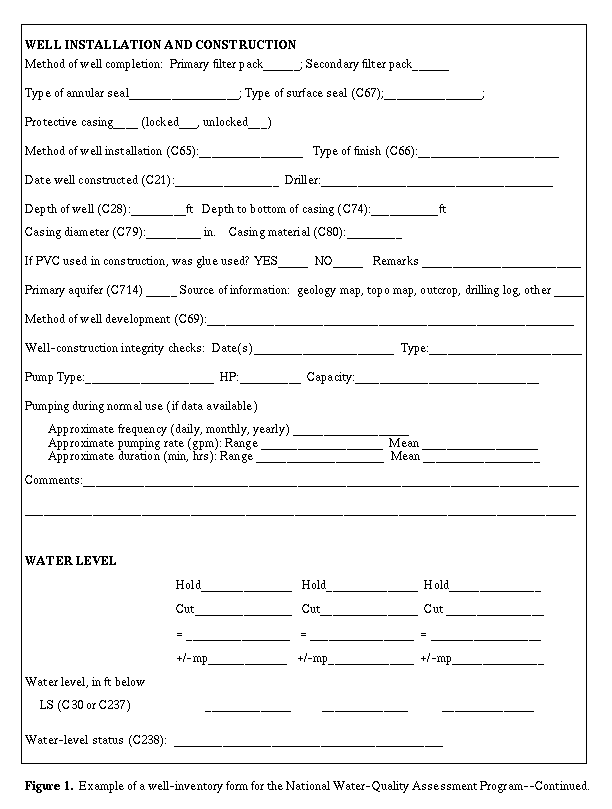
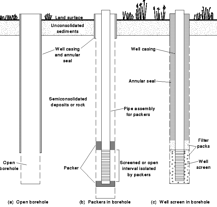
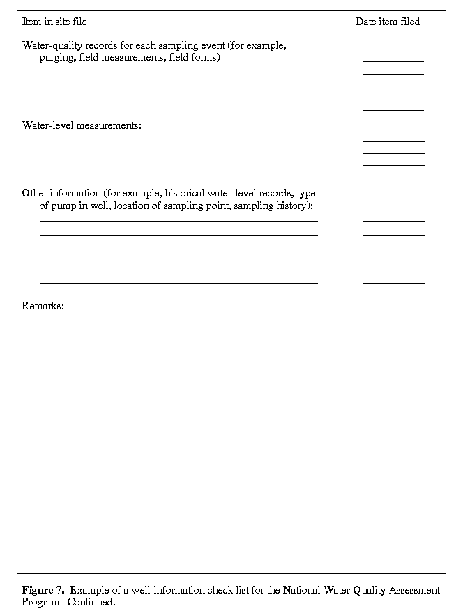
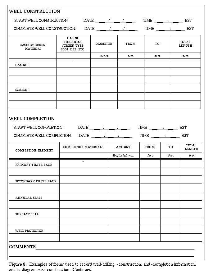
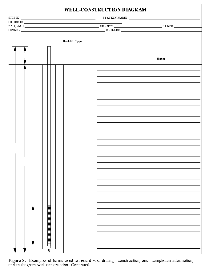
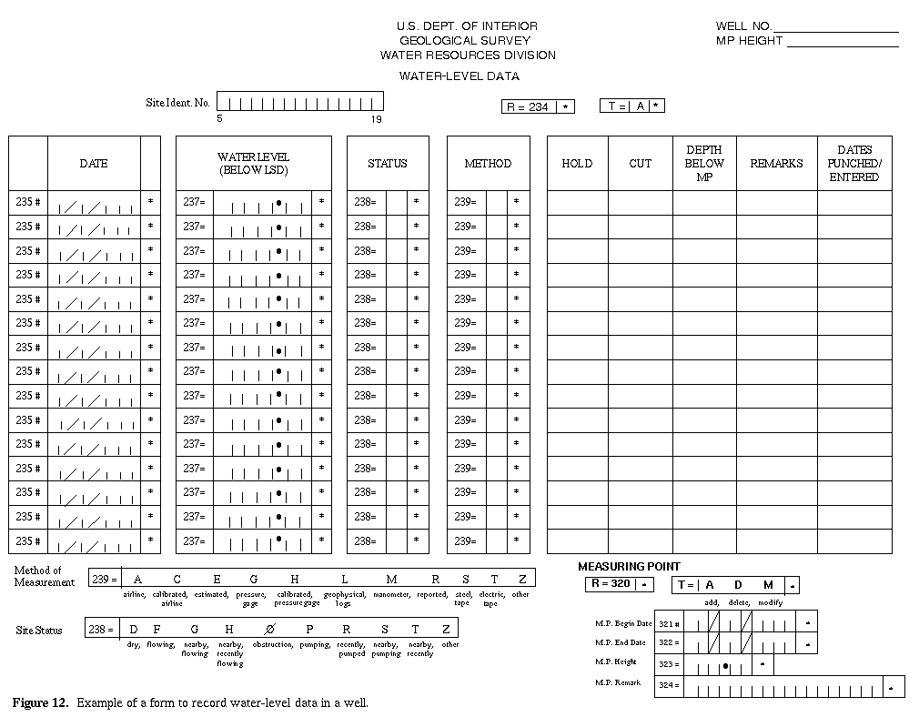
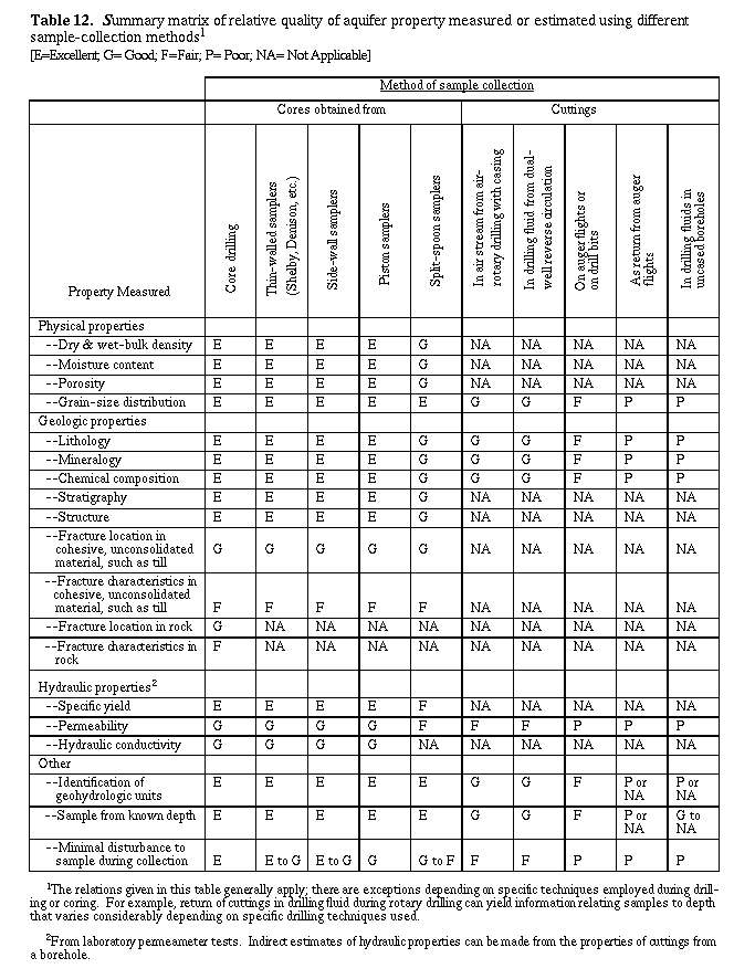